Roxbury Historical Marker Photos


More like Roxbury Historical Marker
Recommended Reviews - Roxbury Historical Marker
Start your review...

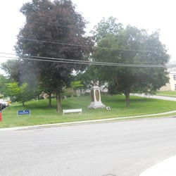
Stars for location - the sign is posted by the main road going into the center of town, in front of the firehouse and across from the deli. It's very easy to park and go observe the sign in person as long as there's no calamity at the firehouse. However, upkeep is questionable. The paint is flaking off, particularly at the top, and definitely needs a touch up. read more
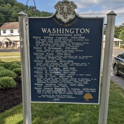
The Roxbury Marker is a real Dr. Jekyll and Mr. Hyde of a marker. The side facing the street is in pretty good condition. But, of Lord, is the side facing away from the street in deplorable condition, with sections of faded, blurred, and plain old missing paint. This is a 2 sided marker from the CT Historical Commission in the familiar white lettering on a blue background. The same inscription is on both sides. It's located on North Street, right in front of the Roxbury Volunteer Fire Department. The marker is more of a "just the facts, ma'am" chronology than the informational description on most of the other markers I've seen. One cool thing I learned was that Ethan Allen was born here! Here's the inscription. 1713 - First structure by white settlers built near Shepaug River. 1732 - 33 - First meeting house erected. Old Roxbury Road. 1743 - Roxbury parish established by Connecticut General Assembly. Birthplace of three cousins of Revolutionary war fame: Captain Remember Baker 1737-1775 Colonel Ethan Allen 1738 - 1789 General Seth Warner 1743 - 1784 1796 - Town of Roxbury incorporated, separating from Woodbury. General Ephraim Hinman of the Connecticut Militia, a Legislator, spearheaded this achievement. Mid-18800's - Mostly a farming town, but with ten sawmills and five hat-making shops. Mine Hill famous for various mineral ores, mainly iron. Garnet, now the State Mineral, was mined and granite quarried for buildings throughout New England and in New York City and transported by Shepaug Railroad. Erected by the Town of Roxbury the Roxbury American Revolution Bicentennial Committee and the Connecticut Historical Commission 1977 read more


More info about Roxbury Historical Marker


Roxbury Historical Marker - landmarks - Updated July 2026
Best of Roxbury
People found Roxbury Historical Marker by searching for…
Browse Nearby
BEST of Roxbury, Connecticut Restaurants near Roxbury Historical Marker
BEST of Roxbury, Connecticut Museums near Roxbury Historical Marker
BEST of Roxbury, Connecticut Parks near Roxbury Historical Marker
BEST of Roxbury, Connecticut Coffee near Roxbury Historical Marker
BEST of Roxbury, Connecticut Things to Do near Roxbury Historical Marker
BEST of Roxbury, Connecticut Breakfast near Roxbury Historical Marker
BEST of Roxbury, Connecticut Campgrounds near Roxbury Historical Marker
BEST of Roxbury, Connecticut Ski Resorts near Roxbury Historical Marker
BEST of Roxbury, Connecticut Hotels near Roxbury Historical Marker


