Cancel

    Open app

    Search

    Alstrom Point

    4.8 (5 reviews)

    Alstrom Point Photos

    You might also consider

    Recommended Reviews - Alstrom Point

    Your trust is our priority, so businesses can't pay to alter or remove their reviews. Learn more about reviews.
    Yelp app icon
    Browse more easily on the app
    Review Feed Illustration

    Reviews With Photos

    Sunset view from the top. Gunsight Butte
    Chris G.

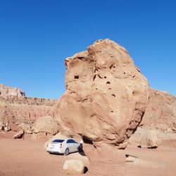
    This is one of those places I'm hesitant to review, as to keep it one of those "hidden gems" of America. Thankfully, it's such a grueling journey to get to this overlook, I'm not too worried about blowing up this spot. I'm very fortunate in that I get to travel for work. I always try and make the most of those opportunities, by finding local excursions and such, wherever I am. In doing so, I've encountered some of the most breathtaking views/vistas in the US; Alstrom Point is easily in the top 5. As I mentioned, it isn't an easy task to get to Alstrom Point. The address listed, is basically just the cross street that leads to the drive up to AP. The actual address is (37.0589° N, 111.3647° W) but you'd do best to not follow your GPS, and go to the website for detailed directions. I tried to use my GPS, as it was basically the same as the web's directions, but it lead me to some areas that were unpassable, and I had to turn around and backtrack. The drive is recommended for 4wd (or high clearance vehicle) but is accessible to 2wd up to a point (3 miles from the top). Having said that, I did the entire thing in my rental KIA Soul (a wannabe SUV), but I grew up in the country off-roading and such, and there were still times where I had to move rocks to fill holes/gaps, turn around and back track; I also bottomed out as well as being uncertain as to whether I'd get stuck- so probably best to follow instructions. The drive from Big Water to the Point is long, at about 23 miles to the 2wd stop, and then another 3 to the top. For the most part, the road is not maintained, so you're lucky to average even 20mph for the trip; expect to give yourself a good 1.5 hours, just for the one-way drive up. But the drive up has incredible beauty in and of itself, with numerous stops worth taking in and photographing. Once you get to the peak, there are numerous vantages. You can see a huge portion of Lake Powell, Gunsight Butte, as well as Warm Creek Bay. The views are absolutely spectacular! I came to watch sunset, but made sure to leave before it got too dark, as the unmarked (only small cairns mark the last little bit) road is difficult to follow.

    See all

    8 years ago

    Helpful 2
    Thanks 0
    Love this 1
    Oh no 1
    Photo of Nina Y.
    168
    165
    26

    8 years ago

    Helpful 0
    Thanks 1
    Love this 0
    Oh no 0
    Photo of T A.
    0
    98
    6

    6 years ago

    Helpful 0
    Thanks 0
    Love this 0
    Oh no 0

    9 years ago

    Helpful 2
    Thanks 1
    Love this 1
    Oh no 0

    8 years ago

    Helpful 0
    Thanks 0
    Love this 0
    Oh no 0

    Verify this business for free

    People searched for Hiking 243 times last month within 15 miles of this business.

    Verify this business

    The Wave at Coyote Buttes - Not crowded but some people hog this area for hours

    The Wave at Coyote Buttes

    4.8(31 reviews)
    18.4 mi

    After years of trying to apply for a permit, our group finally got picked! Highly recommend hiking…read moreat least once. I wouldn't do it again though, mainly because of how hard it was to get a permit. We visited in April and the weather was fantastic. It was actually freezing in the morning but as the sun rose, it warmed up to the point where we would sweat a little when hiking. I can't even imagine doing this in the summer but if you win the lottery then, make sure everyone brings plenty of water. To get to the trailhead, I'd recommend having a high-clearance vehicle, especially if it just recently rained. The road off of the freeway becomes unpaved and there are some ditches that can be flooded. Download an offline map of the trail and area for when you lose service. It gets spotty but you'll find reception every now and then. At the beginning, there are a couple of vault toilets. The trail itself is difficult to follow without an offline map. There's only a handful of signs pointing in a general direction. And until the Wave, we were pretty much the only people around. Considering only about 60 people are approved each day, it wasn't surprising, and honestly, kind of nice to be alone in nature. The Wave was everything we hoped for. We had clear, blue skies and that contrast with the red and orange rocks was beautiful. It looked exactly like the Windows background! There was even a pond further up with a ton of tadpoles. Besides the Wave, there's other neat waypoints to stop by but because we were tired, we didn't try for many of them. The only one we went out of our way for was the dinosaur tracks but it was anti-climatic. They just looked like larger chicken feet prints. Despite this hike being only about 6 miles round trip, it took pretty much the entire day. We stopped a lot to take pictures but also the landscape was difficult to hike. Lots of sand to walk through and lots of weird inclines to walk across, which kept our feet, knees, and legs at weird angles. There might have been easier pathways but as I said earlier, there's no clear indications of a trail. There was also a BLM worker at the Wave asking for the permit holders. If you hike without one and get caught, you'll get slapped with some steep fines. Drones are also not allowed!

    My friend won the online lottery for the permit 4 months in advance but after talking to the…read moreranger, it seems that there's a good chance you can win the daily lottery since a lot of people cancel every day. It's easier if you have less people (like two people). Anyways, the orientation the day before was useful for weather and road conditions. The hike wasn't too bad, can be a bit steep in some parts but for the most part, not too much incline. It's moderate for the novice hiker but easy for an experienced hiker. For experienced hikers, probably can get to the Wave in 1 to 1.5 hours. For the inexperienced, it might take 2.5 to 3 hours. Either way, if you're planning to spend a lot of time at the Wave (some people take 2-3 hours for their extensive Instagram photoshoots haha), definitely go there early and spend all day there. I would definitely come back if I win the lottery!

    Photos
    The Wave at Coyote Buttes
    The Wave at Coyote Buttes
    The Wave at Coyote Buttes

    See all

    Vermilion Cliffs and Chinle Badlands - Attack (Escalante, afternoon sun) - PeterN

    Vermilion Cliffs and Chinle Badlands

    5.0(1 review)
    0.2 mi

    Spend a month here, an hour at a time. Morning light,…read moremidday sun and the sundown hour each change the colors and shapes surrounding you in this eroded and haunting wilderness. Take Highway 89 to Big Water and turn right: the road into the badlands is not marked but it's the only one. It runs ENE along the cliffs at a distance of a mile or so. Occasionally, the dirt road jogs around large boulders that broke away from the cliffs and tumbled out to where you are now. Go there in the early morning. The rising sun finds shadows among the blue seamed cliff faces and the chinle mounds. The attached photograph "Monks" is one of those scenes I captured in the month of May. As the cliffs turn facing the sunrise, direct light outlines sharper shapes and brighter colors, even yellow desert flowers-- as you may see in the attached photo "Stealthfighters." Carbonates in leached clay show a strong green cast in the morning light, see "Peek." Colors in the same clay change in the midday sun, like that in the"Moby Dick" photograph in July. Late afternoon colors emerge in the rocks, as you see in "Attack." Toward sunset the golden hour reveals even more subtle colors in the rocks and clays. These pictures are of the badlands and the lower cliffs. If you get here from anywhere in time for sunrise, you will need to hangout in 100F heat for about 15 hours -- when the colors are least interesting. Or you can go on. Dont try to climb the cliffs or you risk landing under a rock slide -- and become another ghost of the Escalante. There are two roads up to the Kaiparowits plateau. One is mostly narrow switchbacks cut into the sheer face of the 1500-foot Vermilion cliff. When I look over the side, ghosts are waiting.

    Photos
    Vermilion Cliffs and Chinle Badlands - Turning Point (Escalante, sunset) - PeterN

    Turning Point (Escalante, sunset) - PeterN

    Vermilion Cliffs and Chinle Badlands - Entrada (Escalante, sunset) - PeterN

    Entrada (Escalante, sunset) - PeterN

    Vermilion Cliffs and Chinle Badlands - Monks (Escalante, sunrise) - PeterN

    See all

    Monks (Escalante, sunrise) - PeterN

    The Wave - 4/9/2022 (top) compared to 4/20/2025 (bottom).  Not much has changed, including where the shrubs grow.

    The Wave

    4.9(15 reviews)
    19.9 mi

    I've heard the lottery permit for The Wave is one of the hardest to win. I had previously missed…read moreout on the advanced lottery for 3 dates I submitted for mid-May and sorta planned out my 9-day roadtrip in AZ without visiting here. I really only had 1 day to fit in a trip to The Wave while I was staying in Page for 4 days and took a shot with the daily lottery permit and won! I was super pumped when I got the email notification! The 2-day advance daily lottery permit can only be applied for while you are in a nearby geofenced area and you have to pick up the permit and go through orientation/training at either Page, AZ or Kanab, UT. One tricky thing about the permit application hours is that it is based on UT and Navajo time, not AZ time. If you are in Page, you'll have to ignore the local time and make sure you are 1 hour ahead of the daily application closing time. Anyways, this was one of the most jaw-dropping other-worldy places I've hiked. The journey to reach The Wave features some of the most unique terrains and landscapes I've seen. There are geologic features all around, everywhere you look. Once you reach The Wave area, you almost can't believe what you are seeing. Some areas look like the rings of Saturn. Some areas look like huge ocean waves. I was in awe the entire time I was there. I can't even explain everything I saw, as words can't describe the scenery. Just look at the pictures. I didn't really explore past the main area because I was on a tight schedule and needed to head back. I would have to say this hike may be too challenging if you only rely on the paper map provided during orientation. I would highly recommend GPS tracking app, I used AllTrails to track my hike and even then I went off trail a few times, as this is definitely not a straight forward hike. Not a long hike at about 3.3 mile each way, but I would start early as it can get quite hot in this area. Also, there was a gentleman from BLM that was checking for permits at The Wave, if you were curious about enforcement.

    Everyone raves about this place, we hike a lot have done Angels and Half dome so gotta "Wave" right…read more? Took us 3 tries and scored hit early summer, bummer as you do need to plan your hydration carefully as it is dangerous out there when in the 90s We live close enough about a 4 hour drive to Page and overnight and early start to the trail head. Get a rental, you don't want to put your car thru the 9 rough miles and don't even think of doing it if it rains! Higher ground clearance is nice but not necessary but saw mostly SUV, drive your sedan at your own risk, we rented a compact SUV. Watch the weather carefully as for the two days we were there saw afternoon thunderstorms come in and the area did get a little rain the past day, saw some mud and standing water. As to the hike - summer is brutal! Start early, we did at 6am and did 8 miles but not all the attractions as we had to get back to Phoenix. Would it be worth the exhausting 13 miles to see it all, personal decision and gotta have the time. We've done 13 miles but wouldn't consider it here in summer or winter unless you are an Ironman Of course The Wave and Second Wave are amazing as does the arches and others look. We climbed past the second wave and ran outta time Must do, AllTrails or other offline map, the provided map and pictures are not enough. Consider a guide if you are a novice, but the guided tours were grouped and held back by what looked like the older crowd, YMMV. Four stars as between the difficulty with weather the slog the beauty not like Delicate Arch, Half Dome or Angels IMHO

    Photos
    The Wave
    The Wave
    The Wave - Beautiful scenery

    See all

    Beautiful scenery

    Peek-a-boo & Spooky Slot Canyon - Desert Skies

    Peek-a-boo & Spooky Slot Canyon

    4.7(17 reviews)
    25.1 mi

    Peek-a-boo is tight, fun and fairly easy with amazing colors and really interesting rock…read moreformations. Spooky is a lot harder. We had a guide, Gary, from Roam outdoor adventures and glad we did. His help in navigating how to get down from spots through the rocks/boulders that can be rather daunting and dangerous. Though the slots aren't really long, navigating through them is not a quick pass through. They take time. The site could use some signs to get people to start at the right side. Some start at the wrong end and there is no place in these slots for anyone to pass by you. It can get really hot in the summer so 2 liters of water is recommended along with snacks. The ruts in the road can be passed by in a regular car but you will wind up with loose bolts. The road is partially paved there and dirt the rest of the way. Very dusty. Excellent experience. No fee required but donations at the parking lot and restrooms appreciated. Please pack out what you packed in and leave no trace. Some have started writing on the walls of these areas and it's not only awful to have to see but ruins these old sights for everyone. Very disappointing.

    Let me set the record straight, slot canyons are my jam! I will go anywhere there is an opportunity…read moreto walk, shimmy, or rappel into a slot canyon. I just think they are the most interesting Mother Nature created places to explore. We came here on a July 4th holiday with some friends of my husbands. The road out here can be rough in spots and does require a 4X4 to get out here, but we made it safely to the canyon. These slot canyons are located within the Grand Staircase-Escalante National Monument in the beautiful state of Utah. This land is run by the BLM. Talk about beautiful! The canyon walls with their orange/red colored Navajo sandstone just envelopes you as you walk through this slot canyons. So many twists and turns with lots of crevices to peer or climb into. Be sure to pack plenty of water, sunscreen, good trail shoes (not Skechers HA! HA!), a hat and a small pack so you can move through the slot canyons comfortably. Both of these canyons are so worth the drive and the time. Most of all remember to Leave No Trace. Happy Adventuring!

    Photos
    Peek-a-boo & Spooky Slot Canyon - Peek-a-boo

    Peek-a-boo

    Peek-a-boo & Spooky Slot Canyon - Spooky slot canyon

    Spooky slot canyon

    Peek-a-boo & Spooky Slot Canyon - Ancient Moqui Steps in the sandstone

    See all

    Ancient Moqui Steps in the sandstone

    Grand Staircase - Escalante National Monument - Willis Creek Narrows

    Grand Staircase - Escalante National Monument

    4.8(32 reviews)
    21.6 mi

    The Toadstool Hoodoos are cool rock formations formed by differential erosion. They look like…read moremushrooms, as the harder rock caps and protects the softer rock underneath. The hike is an easy 1.5 miles. The views at the end are worth it, and you can get close to the rock formations as you like (although don't topple the rocks!). It's suitable for families with small children. If you don't mind driving on an unpaved road (I did it in a 2WD sedan), check out House Rock Valley Road for unparalleled views of the landscape with swirling sandstone, painted hills, and other cool rock formations. Check out the Wire Pass Trail for amazing slot canyons, although check the weather. If there's any chance for rain, do not enter the slot canyons since the formations channel water and form deadly floods in the canyon.

    This feels like a review in progress because the area is so large - but was pleasantly surprised by…read morehow much more I want to explore this region. We did Willis Creek Narrows and Lower Calf Creek Falls - both incredible. Now adding to the wish list for return trips. The drive along US 12 is just spectacular. Definitely recommend a high clearance vehicle with 4WD to access some of the more remote locations. Be prepared to adventure and bring what you need as this is not a manicured national park, but more a haven for those looking for an off-grid escape.

    Photos
    Grand Staircase - Escalante National Monument - Visitor center

    Visitor center

    Grand Staircase - Escalante National Monument - Visitor center

    Visitor center

    Grand Staircase - Escalante National Monument

    See all

    Horseshoe Bend - Walking Trail

    Horseshoe Bend

    4.7(872 reviews)
    16.1 mi

    I've visited both in June and Sept/October. Both times it's been hot as hell! The wind DOES NOT…read moreHELP AT ALL! BUY the cold water at the entrance if you don't have any! You're gonna need it. Bathrooms available in the parking lot.... NOT along path to nor at the viewing area. Don't get me wrong, the scenery is beyond beautiful and worth every bit of discomfort! This landmark is NOT ADA compliant! One would need an adult stroller or someone to carry anyone who cannot walk the distance across soft dirt/gravel road to get to the viewpoint!

    I hate to give a natural feature such a bad rating, but hear me out. So Horseshoe Bend is in Glen…read moreCanyon National Recreational Area which is free, but the parking lot belongs to the city of Page and you have to pay for it. HOWEVER, the parking lot is also pretty aggressive about shaking you down for money, meaning that there are staffed toll booths, and also one way traffic spikes so that if you drive the wrong way your tires get shredded. Like yes, it is important that people should pay, but it is also very unwelcoming. Also, even though they have brought in over $20 million from the fees so far, they can't even bother to stock their vault toilets with hand sanitizer even at the start of the day. Since there's so many visitors, I can only shudder to think of how many people are walking around with fecal hands. Otherwise, a short stroll leads to a cool view point of the canyon, although the water is lower in the canyon.

    Photos
    Horseshoe Bend - Sand storm!

    Sand storm!

    Horseshoe Bend - My babe and the feral horses

    My babe and the feral horses

    Horseshoe Bend - Watching

    See all

    Watching

    Vermilion Cliffs National Monument

    Vermilion Cliffs National Monument

    4.7(3 reviews)
    18.4 mi

    This place is so underrated on social media--I only discovered it while randomly exploring the map…read more When I checked the Bureau of Land Management's website, I got even more confused because it mentioned that the dirt road requires an AWD and a high-clearance vehicle. As a national monument, I expected there to be an entrance ticket booth. I was traveling from Zion to Flagstaff. but this place was nowhere to be found the yelp map pointer we are taking you to a vista spot where later I realized you can see the whole vermillion from there in the distance. So how did I find it? I want to keep driving. And all the sudden I saw something stunning from the window... if there wasn't and a car parked there selling tribe souvenirs I wouldn't even know I could drive in there... It was a weekday and barely anyone there . The lady that was supposed to be selling the souvenirs was probably sleeping in the car and didn't bother to come out. I don't have high clearance vehicle , so I tried to park at a more flat area... but if you have high clearance vehicle, I think you can drive around all the rock formations without any problem. If not, you can also explore on foot!

    Holy smokes, 280,000 acres! So much to see including a growing number of endangered California…read moreCondors. A lot of the condors are hatched and raised in a breeding program and then released. Although you can get some great shots from the main highway, most of the trails/roads you do need a high clearance vehicle/four wheel drive due to sand being so deep. Most of the roads are all dirt so be cautious if raining etc. if venturing in Coyote Buttes (the wave) you need a permit. Camping is allowed. While you could spend literal days here backpacking etc you still won't see it all. Take your time. I'm bummed we didn't see a condor or two. Maybe on our next trip.

    Photos
    Vermilion Cliffs National Monument - We got to touch California Condor feathers! They're huge! This was part of the 2025 California Condor release event.

    We got to touch California Condor feathers! They're huge! This was part of the 2025 California Condor release event.

    Vermilion Cliffs National Monument - Posing as a California Condor

    Posing as a California Condor

    Vermilion Cliffs National Monument

    See all

    Willis Creek

    Willis Creek

    4.7(3 reviews)
    36.6 mi

    This review is for the Willis Creek Slot Canyon Trail. I've heard of them but never been to one,…read moreand we decided to stop here on the way home to our rental. To get to the trail head, you have to drive in on an unpaved five or so mile road which is scary at times. Make sure you have clearance for your car like the sign says before coming. Our Toyota 4Runner made it through without any problems. After what seems like an eternity because you can't go fast, we got to the head. There's a sign-in book for names, where you're from, and if you're a day or evening/overnight group. Now off to the Slot Canyon! This trail is marked as easy. It's mostly gravel rocks and little steps. My son the adventurous one wanted and did make his own excursion from what others surely have done before. Since it was late afternoon, we decided on a half hour in and then a turn around. The major slot canyon is pretty close to the start of the trail, and it's rather epic. The rocks are so smooth and it can be peaceful in there. I believe because of the remoteness of the canyon, it never seems to be crowded. I would recommend honking shoes, not sneakers, and appropriate clothing for the sun that will bear down on you. Bring lots of water. Watch out for the horse poop! If we weren't so exhausted after a long day, we probably would have hiked along the trail much longer than a half hour, but we definitely got the flavor we were looking for. Have you ever been to an amusement park like Disney where they create mountains and rocks? I can say I've been to the real deal and it's much better.

    Beautiful and special place. Watch out for horse poop up and down the creek. Hike is short and…read moreeasy. The drive up was sketchy, I wouldn't attempt in a 2 wheel drive. We drove an all wheel drive suv and made it. We loved it.

    Photos
    Willis Creek - Instagram: @telephonesmoothie

    Instagram: @telephonesmoothie

    Willis Creek - A natural hole to stick your arm through.

    A natural hole to stick your arm through.

    Willis Creek - Instagram: @telephonesmoothie

    See all

    Instagram: @telephonesmoothie

    Alstrom Point - hiking - Updated July 2026

    Loading...
    Loading...
    Loading...