Wounded Warrior Trail Photos


You might also consider
More like Wounded Warrior Trail
Recommended Reviews - Wounded Warrior Trail
Start your review...

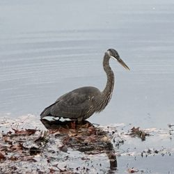
3 months ago
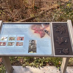
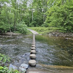
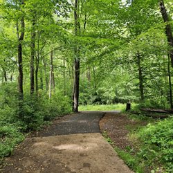
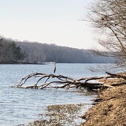
Small trail among many hiking trails in Fort Belvoir. Rarely used and easy trail to hike in Fort Belvoir. It has the most eagles sightings in the area. I discovered this trail in 2023 when I moved here in the summer and found out there were 14 miles of trails to walk & hike in Fort Belvoir. This is the easiest trail to walk and the most peaceful. Many bird & eagle sightings here. It is by an old inactive nuclear plant in Ft. Belvoir. read more


More info about Wounded Warrior Trail
Fort Belvoir, VA 22060
Directions
Hours
Outdoor Amenities
You might also consider


Wounded Warrior Trail - hiking - Updated May 2026
Best of Fort Belvoir
People found Wounded Warrior Trail by searching for…
Things to Do in Fort Belvoir, VA
Hiking Trails in Fort Belvoir, VA
Walking Trails in Fort Belvoir, VA
Running Trails in Fort Belvoir, VA
Easy Hikes in Fort Belvoir, VA
Tourist Attractions in Fort Belvoir, VA
Off Leash Dog Hikes in Fort Belvoir, VA
Places to Take Pictures in Fort Belvoir, VA
Waterfalls and Swimming Holes in Fort Belvoir, VA
Running Tracks Open to the Public in Fort Belvoir, VA
Things to Do This Weekend in Fort Belvoir, VA
Off Road Trails in Fort Belvoir, VA
Hiking Trails Kid Friendly in Fort Belvoir, VA
Walking Groups in Fort Belvoir, VA
Trending Searches in Fort Belvoir, VA
Boat Rental near Wounded Warrior Trail
Botanical Gardens near Wounded Warrior Trail
Bounce House Rentals near Wounded Warrior Trail
Campgrounds near Wounded Warrior Trail
Cherry Picking near Wounded Warrior Trail
Cliff Jumping near Wounded Warrior Trail
Dog Friendly Things To Do near Wounded Warrior Trail
Flower Fields near Wounded Warrior Trail
Flower Shop near Wounded Warrior Trail
Garage Sales near Wounded Warrior Trail
Hair near Wounded Warrior Trail
Lakes & Ponds near Wounded Warrior Trail
Nurseries & Gardening near Wounded Warrior Trail
Outdoor Activities near Wounded Warrior Trail
Outdoor Furniture Stores near Wounded Warrior Trail
Parks near Wounded Warrior Trail
Party Equipment Rentals near Wounded Warrior Trail
Pedicure near Wounded Warrior Trail
Pick Your Own Farms near Wounded Warrior Trail
Picnic Areas near Wounded Warrior Trail
Places To Take Pictures near Wounded Warrior Trail
Running Trails near Wounded Warrior Trail
Scenic Drive near Wounded Warrior Trail
Secret Spots near Wounded Warrior Trail
Strawberry Picking near Wounded Warrior Trail
Sunrise View near Wounded Warrior Trail
Swimming Holes near Wounded Warrior Trail
Table And Chair Rentals near Wounded Warrior Trail
Browse Articles
Browse Nearby
BEST of Fort Belvoir, Virginia Restaurants near Wounded Warrior Trail
BEST of Fort Belvoir, Virginia Coffee near Wounded Warrior Trail
BEST of Fort Belvoir, Virginia Things to Do near Wounded Warrior Trail
BEST of Fort Belvoir, Virginia Parks near Wounded Warrior Trail
BEST of Fort Belvoir, Virginia Breakfast near Wounded Warrior Trail
BEST of Fort Belvoir, Virginia Campgrounds near Wounded Warrior Trail
BEST of Fort Belvoir, Virginia Swimming Holes near Wounded Warrior Trail
BEST of Fort Belvoir, Virginia Hotels near Wounded Warrior Trail
BEST of Fort Belvoir, Virginia Day Trips near Wounded Warrior Trail
Browse Brands
Related Searches in Fort Belvoir, VA
Affordable Kayak Rental Services in Fort Belvoir, Virginia
Best Fishing Locations and Guides in Fort Belvoir, Virginia
Best Nature Trails for Hiking in Fort Belvoir, Virginia
Best Places for Horseback Riding in Fort Belvoir, Virginia
Best Waterfalls and Swimming Holes in Fort Belvoir, Virginia
Check Out Off Road Trails in Fort Belvoir, Virginia
Discover Dog Friendly Trails to Explore in Fort Belvoir, Virginia
Discover Scenic Mountain Bike Trails Near Fort Belvoir, Virginia
Discover Top Nature Parks to Visit in Fort Belvoir, Virginia
Discover a Hiking Trail in Fort Belvoir, Virginia
Discover the Best Night Hike Trails in Fort Belvoir, Virginia
Dog-Friendly Hikes With Dogs in Fort Belvoir, Virginia
Enjoy Camping Adventures Around Fort Belvoir, Virginia
Enjoy Exciting Mountain Biking Adventures in Fort Belvoir, Virginia
Enjoy Kayaking Adventures in Fort Belvoir, Virginia
Enjoy Tent Camping Spots Around Fort Belvoir, Virginia
Enjoy a Beautiful Waterfall Hike in Fort Belvoir, Virginia
Enjoy a Peaceful Nature Walk in Fort Belvoir, Virginia
Enjoy the Best Picnic Spots and Ideas in Fort Belvoir, Virginia
Enjoy the Best Walking Trails in Fort Belvoir, Virginia
Exciting Cliff Jumping Spots in Fort Belvoir, Virginia
Explore Beautiful Parks and Green Spaces in Fort Belvoir, Virginia
Explore Easy Hikes Perfect for All in Fort Belvoir, Virginia
Explore Fun Activities to Do in Fort Belvoir, Virginia
Explore Popular Campgrounds Near Fort Belvoir, Virginia
Explore the Best Beach Spots in Fort Belvoir, Virginia
Explore the Best Swimming Holes Around Fort Belvoir, Virginia
Explore the Best Trail Options in Fort Belvoir, Virginia
Family Friendly Hiking With Kids in Fort Belvoir, Virginia
Find Beautiful Views in Fort Belvoir, Virginia
Find Parks and Recreation Activities in Fort Belvoir, Virginia
Find Popular Ziplining Spots Around Fort Belvoir, Virginia
Find the Best Parks for Picnics in Fort Belvoir, Virginia
Find the Best Scenic View Locations in Fort Belvoir, Virginia
Hiking Trails With Waterfalls in Fort Belvoir, Virginia
Off Leash Dog Hiking Trails in Fort Belvoir, Virginia
Plan Nature Center Visits in Fort Belvoir, Virginia
Plan a Scenic Drive Route Near Fort Belvoir, Virginia
Popular Fishing Spots to Explore in Fort Belvoir, Virginia
Popular Outdoor Activities to Try in Fort Belvoir, Virginia
Popular Picnic Spots to Visit in Fort Belvoir, Virginia
Safe River Swimming Areas in Fort Belvoir, Virginia
Safe and Fun Parks for Kids in Fort Belvoir, Virginia
Top Climbing Spots and Gyms in Fort Belvoir, Virginia
Top Paddleboarding Activities in Fort Belvoir, Virginia
Top Places for Snorkeling in Fort Belvoir, Virginia
Top Running Trails to Explore in Fort Belvoir, Virginia
Top Swimming Lakes to Enjoy in Fort Belvoir, Virginia
People who viewed Wounded Warrior Trail also viewed
Dogue Creek Blue Park
1 review
Valleycrest Park
3 reviews
Shaw Heritage Trail
1 review
Shaw
Fort Totten Park
4 reviews
Fort Totten
Worthy Ambition
1 review
Bloomingdale, Edgewood
Melvin C Hazen Park
8 reviews
Cleveland Park
Manassas National Battlefield Park
177 reviews
Pershing Square Park
8 reviews
Fairfax Ruins Trail
1 review
Shipyard Park
2 reviews