Wedgwood Rock Photos


More like Wedgwood Rock
Recommended Reviews - Wedgwood Rock
Start your review...



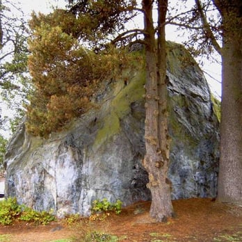
It's a famous line from a mediocre movie: "That's not a knife, THAT'S a knife!" The movie of course is Crocodile Dundee staring Paul Hogan. It is utterly forgettable and in fact, I have forgotten everything about it, except when I visit my neighborhood's biggest tourist draw, the Wedgwood Rock. "That's not a rock, THAT'S a rock!" Standing 19 feet tall and deposited by glacial ice sheets tens of thousands of years ago, the Wedgwood Rock is a humbling reminder of just how little control we humans have over our grand Mother Earth. According to Dr. Terry W. Swanson, of the UW Department of Geological Sciences, the Wedgwood Rock has its origins on Fidalgo Island, near Anacortes, about 75 miles north of Seattle. It was carried 75 miles and by ice sheets and then deposited in little old Wedgwood as the most recent ice age ended (source: http://bit.ly/WcjCNQ). Admittedly, the Wedgwood Rock doesn't quite rank up there with Seattle's top tourist draws, but it's always a lot of fun to take visitors on a drive by and watch their eyes bulge as we round the corner to 28th Ave NE and the rock comes into view. Kudos to the neighbors of the Wedgwood Rock who have assumed the role of caretakers for the iconic boulder, from enforcing the climbing ban, to gardening around it, to making sure graffiti gets cleaned up promptly. It's a bit ironic, of course, that the Wedgwood Rock isn't actually in the Wedgwood neighborhood, which is widely considered to encompass the boundaries of NE 95th St to NE 75th St, between 45th Ave NE on the east to a combination of Lake City Way, Ravenna Ave NE, and 25th Ave NE on the west (Source: http://bit.ly/Wcm6vI). Technically I suppose it would be the Ravenna neighborhood that the rock actually resides in. Still, that bit of trivia doesn't detract from the neighborhood's love for its most famous attraction, nor its appeal to young and old alike. Tip: While the Wedgwood Rock may be the neighborhood's largest and most famous glacial erratic, it is hardly the only one. Check out the Wedgwood Rock's modest sibling located in a tiny park known as Wedgwood Square at the corner of 31st Ave NE and NE 82nd Street. read more


I love "The Rock". There is something magical about cruising through a cute residential community and seeing a gigantic boulder sitting in the middle of a sidewalk. I'm so happy they didn't blast this landmark to pieces. It's the definition of local flavor. A lot of people make special trips to come gawk at the natural wonder. I personally think it's worth a side trip if you are out in the area. And so do a lot of other people. You'll even see the climbing ropes hanging from the branches, of course you aren't supposed to climb it. ($100 fine if you are caught!) The neighbors in the area keep the rock tidy and clean of graffiti and back in the day used to decorate the rock for the holidays! There are plenty of school groups from elementary to university that come to check out the rock too. It reminds you that, you are sort of insignificant in the natural history of the world. And I appreciate that. read more


10 years ago