Virgin Falls Pocket Wilderness Photos


More like Virgin Falls Pocket Wilderness
Recommended Reviews - Virgin Falls Pocket Wilderness
Start your review...


6 years ago
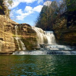
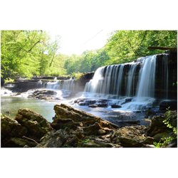
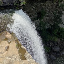
Absolutely beautiful!! I went with my neighbors and we had a great time! The virgin falls is huge and it's stunning, we are going back and camping nearby. Can't get enough! read more


13 years ago
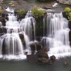
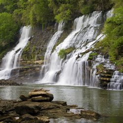
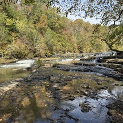
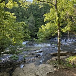
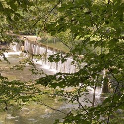
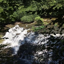
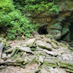
This is hands-down my favorite hiking trail in the area. Virgin Falls is 1,157-acre natural area located adjacent to the Bridgestone Firestone Centennial Wilderness in White County (Sparta, TN). The hike is to the falls is about 5-9 hours round-trip depending on your pace. There are fire pits for overnight camping, located at the falls. My favorite part: About 3 hours into your hike... there is a place dubbed 'Blue Hole' by the older residents of Sparta, in which the algae creates a blue-green effect in the water. It is perfectly safe to swim in, and deep enough to provide an effective "swimming hole". On hot summer days it's perfect. There is a copse of trees that follows the river/creek that are wavy for no apparent reason, but the overall effect is an Alice-in-wonderland kind of look. I'm uploading a few photos, but I was obsessed with darkening photos back then. read more

More info about Virgin Falls Pocket Wilderness
Scott & Gulf Road
Fl 7, Lc Annex
Sparta, TN 38583
Directions
(615) 532-0431
Call Now
Hours
Outdoor Amenities


Why does Yelp recommend reviews?
Virgin Falls Pocket Wilderness - parks - Updated May 2026
Best of Sparta
People found Virgin Falls Pocket Wilderness by searching for…
Things to Do in Sparta, Tennessee
Swimming Holes in Sparta, Tennessee
Campgrounds in Sparta, Tennessee
Hiking Trails With Waterfalls in Sparta, Tennessee
Places to Swim in Sparta, Tennessee
Scenic Drive in Sparta, Tennessee
River Swimming in Sparta, Tennessee
Waterfalls in Sparta, Tennessee
Places to Take Pictures in Sparta, Tennessee
Swimming Lakes in Sparta, Tennessee
Photo Spots in Sparta, Tennessee
Walking Trails in Sparta, Tennessee
Running Trails in Sparta, Tennessee
Scenic Views in Sparta, Tennessee
Beautiful Views in Sparta, Tennessee
Easy Hikes in Sparta, Tennessee
View Points in Sparta, Tennessee
Camping Sites in Sparta, Tennessee
State Park in Sparta, Tennessee
Trending Searches in Sparta, TN
Baseball Fields near Virgin Falls Pocket Wilderness
Bird Sanctuary near Virgin Falls Pocket Wilderness
Boat Rental near Virgin Falls Pocket Wilderness
Botanical Gardens near Virgin Falls Pocket Wilderness
Bounce House Rentals near Virgin Falls Pocket Wilderness
Campgrounds near Virgin Falls Pocket Wilderness
Cheap Plants near Virgin Falls Pocket Wilderness
Dog Friendly Trails near Virgin Falls Pocket Wilderness
Floral Designers near Virgin Falls Pocket Wilderness
Flower Shop near Virgin Falls Pocket Wilderness
Garage Sales near Virgin Falls Pocket Wilderness
Garden Center near Virgin Falls Pocket Wilderness
Lakes near Virgin Falls Pocket Wilderness
Nurseries & Gardening near Virgin Falls Pocket Wilderness
Outdoor Furniture Stores near Virgin Falls Pocket Wilderness
Party Equipment Rentals near Virgin Falls Pocket Wilderness
Pedicure near Virgin Falls Pocket Wilderness
Photo Spots near Virgin Falls Pocket Wilderness
Picnic Areas near Virgin Falls Pocket Wilderness
Playgrounds near Virgin Falls Pocket Wilderness
Public Shower near Virgin Falls Pocket Wilderness
Rock Quarry near Virgin Falls Pocket Wilderness
Rv Rental near Virgin Falls Pocket Wilderness
Browse Articles
Browse Brands
Related Searches in Sparta, TN
Best Water Parks for Kids in Sparta, Tennessee
Best Waterfalls and Swimming Holes in Sparta, Tennessee
Check Out Great Playgrounds in Sparta, Tennessee
Check Out Off Road Trails in Sparta, Tennessee
Discover Baseball Fields Around Sparta, Tennessee
Discover Fun Activities to Do in Sparta, Tennessee
Discover Popular Photo Spots in Sparta, Tennessee
Discover Top Nature Parks to Visit in Sparta, Tennessee
Discover the Best Beaches in Sparta, Tennessee
Discover the Best Fishing Lake in Sparta, Tennessee
Enjoy the Best Walking Trails in Sparta, Tennessee
Explore Easy Hikes Perfect for All in Sparta, Tennessee
Explore Family-Friendly Zoos and Wildlife in Sparta, Tennessee
Explore Fun Activities to Do in Sparta, Tennessee
Explore Landmarks & Historical Buildings in Sparta, Tennessee
Explore Parks With Pull Up Bars in Sparta, Tennessee
Explore Popular Campgrounds Near Sparta, Tennessee
Explore Popular Picnic Areas Around Sparta, Tennessee
Explore Popular RV Parks Around Sparta, Tennessee
Explore Popular Recreation Centers Around Sparta, Tennessee
Explore Popular Scenic Overlook Points in Sparta, Tennessee
Explore Popular Scenic Views Near Sparta, Tennessee
Explore Scenic Lakes to Visit in Sparta, Tennessee
Explore Top Dog Parks in Sparta, Tennessee Near You
Explore Top Gyms in Sparta, Tennessee Now
Explore Top Water Parks in Sparta, Tennessee Today
Explore the Best Swimming Holes Around Sparta, Tennessee
Find Beautiful Views in Sparta, Tennessee
Find Parks and Recreation Activities in Sparta, Tennessee
Find Top Dog Friendly Parks to Visit in Sparta, Tennessee
Find Top Skate Parks in Sparta, Tennessee for All Skill Levels
Find Top Skating Rinks in Sparta, Tennessee for All Ages
Find Top-Rated Waterfalls in Sparta, Tennessee Now
Find the Best Parks for Picnics in Sparta, Tennessee
Find the Best Swimming Pools in Sparta, Tennessee Today
Fun Things for Kids in Sparta, Tennessee
Great Places to Swim in Sparta, Tennessee
Have Fun at a Splash Pad in Sparta, Tennessee
Hiking Trails With Waterfalls in Sparta, Tennessee
Indoor Playgrounds to Explore in Sparta, Tennessee
Plan a Scenic Drive Route Near Sparta, Tennessee
Popular Kids Activities in Sparta, Tennessee
Popular Places to Take Pictures in Sparta, Tennessee
Popular Things to Do in Sparta, Tennessee
Top Hiking Trails to Explore in Sparta, Tennessee
Top Running Trails to Explore in Sparta, Tennessee
Top Swimming Lakes to Enjoy in Sparta, Tennessee
Top-Rated Basketball Courts to Play at in Sparta, Tennessee
People who viewed Virgin Falls Pocket Wilderness also viewed
Ozone Falls
39 reviews
Cumberland Mountain State Park
34 reviews
Ozone Falls
6 reviews
Burgess Falls State Park
80 reviews
Millikan's Overlook and Buzzard's Roost
1 review
Kayaking Adventures of Tennessee
12 reviews
Central Trails Paved Paths Nature Trails
1 review
Fall Creek Falls Riding Stables
8 reviews
Rhea Harbor
2 reviews
Tennessee Hills Golf Course
3 reviews