Tynehead Regional Park Photos


You might also consider
More like Tynehead Regional Park
Recommended Reviews - Tynehead Regional Park
Start your review...

Reviews With Photos

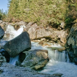
First time at this park! It is very big with looping trails - a perfect long walk in the Fall. Was lucky enough to see a few salmon swimming upstream! It was really exciting to watch the power of their tails. The viewpoints are easier while watching over top the bridges. Lots of maps in the area and at most forks in the road - you really can't get lost. Beautiful and relatively quiet!!


While in town for a business trip (end of October 2015), I decided to get out for a walk in the late afternoon between rain showers. I used my iPhone to Google nearby parks and Tynehead popped up. I was nearby, so I decided to give it a closer look. Upon entering one of the parking lots, I saw a trail map and other info posted and checked it all out. I was thrilled to see a loop trail and thought that could give me a nice :45 minute walk - it worked perfectly! I loved the wooded areas and old barn. The only down side was being right next to the highway along one stretch - quite noisy and distracting from the wooded beauty. Luckily, that portion ended quickly and I was back amongst the amazing foliage. A perfect spot for an afternoon walk (or a nice bike ride on a wide path.) 4 stars!


Beautiful park in north eastern Surrey that is very dog friendly (verrry large off leash area), outdoor picnic tables, hot coal bin for barbecues, hatchery, several creeks, restrooms and a few parking lots. The paths are almost all flat, easy, wide and well marked. Can be a quite deserted/quiet on weekdays. One thing I don't like about this park is how isolated the main parking lot feels on weekdays. Signs indicate car break-ins are an issue. I don't think I'd feel safe coming alone as a female if it was a weekday or if it wasn't bright. But a very nice and walkable park on bright, sunny days w friends/family. read more


3 years ago
Trail Series, Part 23 "Love is in the air. Everywhere I look around. Love is in the air. Every sight and every sound." John Paul Young When some members of our Review Team set off to explore during our afternoon run, I can assure you that none of us intended to...um, interrupt anything, but that is kind of how we felt when we happened upon significant groups of spawning salmon. While enjoying the natural beauty of "Tynehead Regional Park" located in Surrey (just outside of Vancouver) we noticed small numbers of fellow outdoor enthusiasts peering into the various creeks and rivers along the paths and felt privileged to witness this process. For those not able to visit this time of year, or for those who's thoughts first land on images of their four legged friends after the term "love" is uttered, this park also offers the largest "leash optional area" for dogs that I've ever encountered. We ran through literally acres of space for your friend to stretch his/her legs and do a little mingling, if desired. And that's...Henry's Take. #canadiansalmon #urbanspawningadventures read more


First time at this park! It is very big with looping trails - a perfect long walk in the Fall. Was lucky enough to see a few salmon swimming upstream! It was really exciting to watch the power of their tails. The viewpoints are easier while watching over top the bridges. Lots of maps in the area and at most forks in the road - you really can't get lost. Beautiful and relatively quiet!! read more


6 years ago
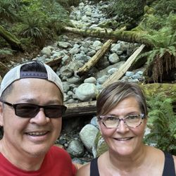
I love this park. Great for cyclists and pedestrians with lots of room to keep social distancing. It's about a 6km walk around and also a separate dog park to let your fur babies run around. Not too busy from 1-3pm during the week. Lots of parking. read more


10 years ago
While in town for a business trip (end of October 2015), I decided to get out for a walk in the late afternoon between rain showers. I used my iPhone to Google nearby parks and Tynehead popped up. I was nearby, so I decided to give it a closer look. Upon entering one of the parking lots, I saw a trail map and other info posted and checked it all out. I was thrilled to see a loop trail and thought that could give me a nice :45 minute walk - it worked perfectly! I loved the wooded areas and old barn. The only down side was being right next to the highway along one stretch - quite noisy and distracting from the wooded beauty. Luckily, that portion ended quickly and I was back amongst the amazing foliage. A perfect spot for an afternoon walk (or a nice bike ride on a wide path.) 4 stars! read more


8 years ago
Nice park with paved walkways, won't have to worry getting the shoes dirty. Lots of parking and well maintained picnic area. About 5 km walk loop is just right read more


12 years ago
9 years ago
More info about Tynehead Regional Park
Surrey, BC
Canada
Directions
Hours
Outdoor Amenities


Why does Yelp recommend reviews?
1 review that is not currently recommended
The reviews below are not factored into the business's overall star rating.
12 years ago
Tynehead Regional Park - hiking - Updated May 2026
People found Tynehead Regional Park by searching for…
Fishing in Surrey, British Columbia
Views in Surrey, British Columbia
Playgrounds in Surrey, British Columbia
Hiking Trails in Surrey, British Columbia
Dog Swimming in Surrey, British Columbia
Picnic Areas in Surrey, British Columbia
Off Leash Dog Parks in Surrey, British Columbia
Picnic Parks in Surrey, British Columbia
Tourist Attractions in Surrey, British Columbia
Places to Take Pictures in Surrey, British Columbia
Walking Trails in Surrey, British Columbia
Fishing Spots in Surrey, British Columbia
Scenic View in Surrey, British Columbia
Running Trails in Surrey, British Columbia
Scenic Drive in Surrey, British Columbia
Picnic Spots in Surrey, British Columbia
Night View in Surrey, British Columbia
Off Road Trails in Surrey, British Columbia
Parks for Kids in Surrey, British Columbia
Secluded Spots in Surrey, British Columbia
BBQ Park in Surrey, British Columbia
Flower Fields in Surrey, British Columbia
Browse Articles
Browse Brands
Related Searches in Surrey, BC
Affordable Kayak Rental Services in Surrey, British Columbia
Best Fishing Locations and Guides in Surrey, British Columbia
Best Off Leash Dog Parks in Surrey, British Columbia
Best Places for Horseback Riding in Surrey, British Columbia
Best Water Parks for Kids in Surrey, British Columbia
Check Out Great Playgrounds in Surrey, British Columbia
Check Out Off Road Trails in Surrey, British Columbia
Discover Baseball Fields Around Surrey, British Columbia
Discover Beautiful Garden Spots in Surrey, British Columbia
Discover Free Parking Options in Surrey, British Columbia
Discover Fun Toddler Parks in Surrey, British Columbia for Your Little One
Discover Kid Friendly Hiking Trails in Surrey, British Columbia
Discover Lakes & Ponds to Explore in Surrey, British Columbia
Discover Popular Photo Spots in Surrey, British Columbia
Discover Scenic Mountain Bike Trails Near Surrey, British Columbia
Discover Scenic Waterfall Spots in Surrey, British Columbia
Discover Soccer Fields in Surrey, British Columbia Near You
Discover the Best Beaches in Surrey, British Columbia
Discover the Best Kids Park Spots in Surrey, British Columbia
Discover the Best Night Hike Trails in Surrey, British Columbia
Discover the Best Running Track in Surrey, British Columbia
Enjoy Camping Adventures Around Surrey, British Columbia
Enjoy Exciting Mountain Biking Adventures in Surrey, British Columbia
Enjoy Kayaking Adventures in Surrey, British Columbia
Enjoy Tent Camping Spots Around Surrey, British Columbia
Enjoy Water Activities and Fun in Surrey, British Columbia
Enjoy a Beautiful Waterfall Hike in Surrey, British Columbia
Enjoy the Best Family Activities in Surrey, British Columbia
Enjoy the Best Picnic Spots and Ideas in Surrey, British Columbia
Enjoy the Best Walking Trails in Surrey, British Columbia
Exciting Cliff Jumping Spots in Surrey, British Columbia
Experience Thrilling White Water Rafting in Surrey, British Columbia
Explore Beautiful Botanical Gardens in Surrey, British Columbia
Explore Beautiful Parks and Green Spaces in Surrey, British Columbia
Explore Family-Friendly Zoos and Wildlife in Surrey, British Columbia
Explore Free Picnic Areas Around Surrey, British Columbia
Explore Fun Activities to Do in Surrey, British Columbia
Explore Parks With Pull Up Bars in Surrey, British Columbia
Explore Popular Campgrounds Near Surrey, British Columbia
Explore Popular Picnic Areas Around Surrey, British Columbia
Explore Popular RV Parks Around Surrey, British Columbia
Explore Popular Recreation Centers Around Surrey, British Columbia
Explore Scenic Lakes to Visit in Surrey, British Columbia
Explore Top Dog Parks in Surrey, British Columbia Near You
Explore Top Water Parks in Surrey, British Columbia Today
Explore the Best Beach Spots in Surrey, British Columbia
Explore the Best Boating Spots in Surrey, British Columbia
Explore the Best Swimming Holes Around Surrey, British Columbia
People who viewed Tynehead Regional Park also viewed
Mundy Park
18 reviews
Green Timbers Urban Forest
7 reviews
Watershed Park
12 reviews
Deas Island Regional Park
11 reviews
Pacific Spirit Regional Park
52 reviews
UBC
Lynn Canyon Park
71 reviews
Lynn Valley
Byrne Creek Ravine Park
5 reviews
Lions Park
5 reviews
Como Lake Park
11 reviews
Stanley Park
1207 reviews
Coal Harbour