Tupancy Links Photos


 - Hiking Near Me - Nantucket, Massachusetts")
You might also consider
More like Tupancy Links
Recommended Reviews - Tupancy Links
Start your review...

12 years ago
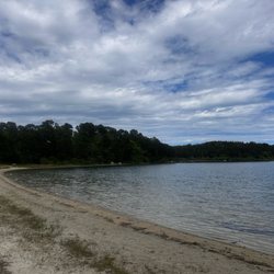
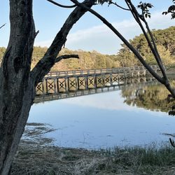
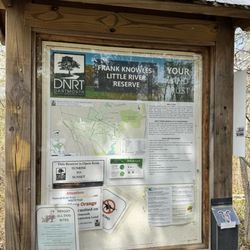
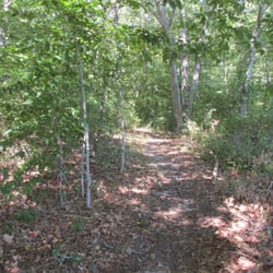
A great little trail for you and your pup maintained by the Nantucket Conservation Foundation. It's a little over a mile up from Cliff Road to the cliff. Enjoy breathtaking views and watch the boats come in to Nantucket harbor. The area used to be an old golf course, called Tupancy Links. Today, it is dog heaven - there's plenty of space to for your dog to run, and it's encouraged. Walk, bike, or drive there- there's plenty of parking as well. read more


More info about Tupancy Links


Tupancy Links - hiking - Updated June 2026
Best of Nantucket
People found Tupancy Links by searching for…
Walking Trails in Nantucket, Massachusetts
Hiking Trails in Nantucket, Massachusetts
Running Trails in Nantucket, Massachusetts
Things to Do in Nantucket, Massachusetts
Sunrise View in Nantucket, Massachusetts
Secluded Spots in Nantucket, Massachusetts
Scenic Overlook in Nantucket, Massachusetts
Sand Dunes in Nantucket, Massachusetts
Off Leash Dog Hikes in Nantucket, Massachusetts
Lookout Points in Nantucket, Massachusetts
Playground in Nantucket, Massachusetts
Waterfall Hike in Nantucket, Massachusetts
Waterfalls in Nantucket, Massachusetts
Picnic Areas in Nantucket, Massachusetts
Dog Friendly Trails in Nantucket, Massachusetts
Duck in Nantucket, Massachusetts
Easy Hikes in Nantucket, Massachusetts
Scenic Night View in Nantucket, Massachusetts
Flower Fields in Nantucket, Massachusetts
Kid Friendly in Nantucket, Massachusetts
Places to Walk Around in Nantucket, Massachusetts
Trail in Nantucket, Massachusetts
Trending Searches in Nantucket, MA
Amusement Parks near Tupancy Links
Bait And Tackle Shop near Tupancy Links
Black Owned Nail Salons near Tupancy Links
Boat Rental near Tupancy Links
Cliff Jumping near Tupancy Links
Fishing Spots near Tupancy Links
Jet Ski Rental near Tupancy Links
Kayak Rental near Tupancy Links
Pick Your Own Farms near Tupancy Links
Public Shower near Tupancy Links
Running Trails near Tupancy Links
Scenic Drive near Tupancy Links
Secluded Spots near Tupancy Links
Strawberry Picking near Tupancy Links
Sunrise View near Tupancy Links
Swimming Holes near Tupancy Links
Swimming Lakes near Tupancy Links
Swimming Pools near Tupancy Links
Watch Sunset near Tupancy Links
Browse Articles
Browse Nearby
BEST of Nantucket, Massachusetts Restaurants near Tupancy Links
BEST of Nantucket, Massachusetts Things to Do near Tupancy Links
BEST of Nantucket, Massachusetts Coffee near Tupancy Links
BEST of Nantucket, Massachusetts Parks near Tupancy Links
BEST of Nantucket, Massachusetts Campgrounds near Tupancy Links
BEST of Nantucket, Massachusetts Lakes near Tupancy Links
BEST of Nantucket, Massachusetts Breakfast near Tupancy Links
BEST of Nantucket, Massachusetts Visitor Centers near Tupancy Links
Browse Brands
Related Searches in Nantucket, MA
Affordable Kayak Rental Services in Nantucket, Massachusetts
Best Fishing Locations and Guides in Nantucket, Massachusetts
Best Places for Horseback Riding in Nantucket, Massachusetts
Best Spots for Star Gazing in Nantucket, Massachusetts
Check Out Off Road Trails in Nantucket, Massachusetts
Discover Dog Friendly Trails to Explore in Nantucket, Massachusetts
Discover Popular Photo Spots in Nantucket, Massachusetts
Discover Scenic Mountain Bike Trails Near Nantucket, Massachusetts
Discover Top Boat Tours in Nantucket, Massachusetts for All Ages
Discover a Hiking Trail in Nantucket, Massachusetts
Discover the Best Night Hike Trails in Nantucket, Massachusetts
Discover the Best Running Track in Nantucket, Massachusetts
Dog-Friendly Hikes With Dogs in Nantucket, Massachusetts
Enjoy Exciting Mountain Biking Adventures in Nantucket, Massachusetts
Enjoy Kayaking Adventures in Nantucket, Massachusetts
Enjoy the Best Tubing Experiences in Nantucket, Massachusetts
Enjoy the Best Walking Trails in Nantucket, Massachusetts
Exciting Cliff Jumping Spots in Nantucket, Massachusetts
Experience Stunning Sunset Views in Nantucket, Massachusetts
Explore Beautiful Botanical Gardens in Nantucket, Massachusetts
Explore Beautiful Parks and Green Spaces in Nantucket, Massachusetts
Explore Bike Rentals Throughout Nantucket, Massachusetts
Explore Easy Hikes Perfect for All in Nantucket, Massachusetts
Explore Fun Activities to Do in Nantucket, Massachusetts
Explore Popular Campgrounds Near Nantucket, Massachusetts
Explore Popular RV Parks Around Nantucket, Massachusetts
Explore Scenic Lakes to Visit in Nantucket, Massachusetts
Explore Top Dog Parks in Nantucket, Massachusetts Near You
Explore Top Water Parks in Nantucket, Massachusetts Today
Explore Whale Watching Tours in Nantucket, Massachusetts
Explore the Best Beach Spots in Nantucket, Massachusetts
Explore the Best Boating Spots in Nantucket, Massachusetts
Family Friendly Hiking With Kids in Nantucket, Massachusetts
Find Popular Ziplining Spots Around Nantucket, Massachusetts
Find the Best Playgrounds to Visit in Nantucket, Massachusetts
Off Leash Dog Hiking Trails in Nantucket, Massachusetts
Plan a Scenic Drive Route Near Nantucket, Massachusetts
Popular Fishing Spots to Explore in Nantucket, Massachusetts
Popular Kids Activities in Nantucket, Massachusetts
Popular Places to Take Pictures in Nantucket, Massachusetts
Popular Things to Do in Nantucket, Massachusetts
Safe and Fun Parks for Kids in Nantucket, Massachusetts
Top Climbing Spots and Gyms in Nantucket, Massachusetts
Top Fishing Charter Experiences in Nantucket, Massachusetts
Top Places for Snorkeling in Nantucket, Massachusetts
Top Playgrounds for Kids to Enjoy in Nantucket, Massachusetts
Top Running Trails to Explore in Nantucket, Massachusetts
Top Things to Do With Kids in Nantucket, Massachusetts