Trans Mountain Road Photos


More like Trans Mountain Road
Recommended Reviews - Trans Mountain Road
Start your review...

Reviews With Photos

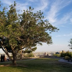
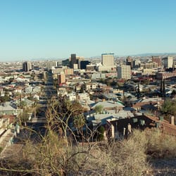
Since the Summer of 1969 Woodrow Bean Trans Mountain Highway has been a top of the line engineering and excavation work featuring a lovely drive through the mountains from west to east or east to west in El Paso, Texas. Depending on your destination driving through it can significantly cut your drive time down to 20 minutes less. It has breathtaking views and access to different hiking trails. Sadly not all people feel comfortable driving it and it shows making it dangerous specially for truck drivers. You may also stop and park to enjoy the majestic views covering Texas, New Mexico and Mexico. Given the time when it was built I am amazed at the ambitious and successful project. It took some genius calculations to get it done with dynamite. Every time I drive through the magnitude of its engineering blows my mind.


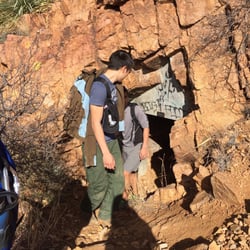
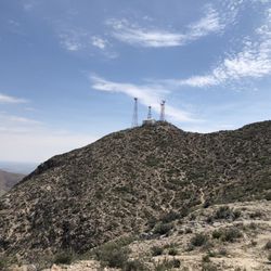
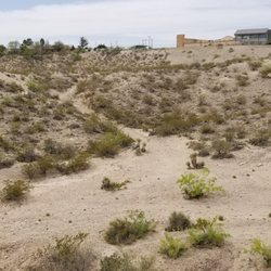
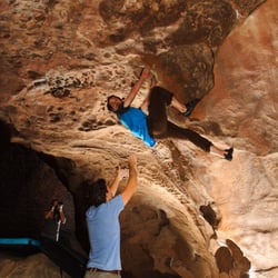
This is a must do for any visitor - doesn't matter which side of the mountain you start on, both sides have gorgeous scenery of the city and the mountains. Look out for falling rocks - thats not just something they say - they really do fall - just look at the ones in the median for an idea. There are also snakes and deer to watch for, as well as mountain lions and the occasional bear. After all, it IS part of a mountain range, right? If you decide to hike - please note that part is government property with its own set of hazards - and not for public use. There are several places to pull off the road and check out the views and enjoy picnics under the awnings on the tables. Its really nice.

9 months ago


Scenic drives are kind of my thing, and the drive up Trans Mountain Road was completely satisfying. Not only is the drive an adrenaline rush (albeit a tad bit scary too), the city views are quite astounding at the top. It's also an excellent way to skip the traffic when traveling from New Mexico to El Paso (and probably visa versa but can't confidently confirm that part). I was leaving New Mexico after having a wonderful dinner and saw that there was a ton of traffic getting back to El Paso on my GPS. It suggested an alternate route; Trans Mountain Road. Normally, I'd probably just sit in traffic when I'm in an unfamiliar place. I'm from the Bay Area (California), and I am no stranger to horrible traffic. But who the hell wants to sit in traffic while they're on vacation?! I already deal with that 5 days out of the week, so spare me. It was still daylight so I decided to do it. I've driven on many windy roads, but I'll admit that this one was kind of nerve racking. Mostly because some of you Texans just don't know how to drive (sorry, not sorry). But once I got to the top of the hill and those views started to appear, it became enjoyable. I saw a vista point with a few cars parked in the distance and immediately pulled off to park there. Yep, this was it. I hit the jackpot. The pictures of the vista point doesn't do it justice. The views are outstanding! Panoramic beauty and lots of it. There's even a cute little lookout point and some picnic tables up there. It was windy as hell though, so not sure if I'd sit out there and eat something for fear of being blown over. Maybe in the summer when the weather is warmer and the winds are milder, but still. Fantastic city views of El Paso and some nice views of the New Mexican desert hills. This is definitely a hidden chill spot. I can only imagine how gorgeous the sunrises and sunsets are, but I'm sure it's even gnarlier to drive this road when it's dark. In any event, it's a lovely vista with an adventurous drive and a nice escape from traffic. read more


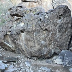
TransMountain will always hold a special place in my heart... When COVID hit, I had just met my current gf. We weren't able to do normal couple stuff like going to the movies or going out to dinner so we spent countless hours sitting on this mountain looking at the city lights and talking. This is also the place I asked my gf to be my gf. If you want to do a could mountain hike, this is a good place. If you want to sit and have a picnic, this is also a good place. If you just want to go out for a drive and enjoy the scenery, definitely recommend through here and don't miss the giant rock that looks like an elephant read more


Since the Summer of 1969 Woodrow Bean Trans Mountain Highway has been a top of the line engineering and excavation work featuring a lovely drive through the mountains from west to east or east to west in El Paso, Texas. Depending on your destination driving through it can significantly cut your drive time down to 20 minutes less. It has breathtaking views and access to different hiking trails. Sadly not all people feel comfortable driving it and it shows making it dangerous specially for truck drivers. You may also stop and park to enjoy the majestic views covering Texas, New Mexico and Mexico. Given the time when it was built I am amazed at the ambitious and successful project. It took some genius calculations to get it done with dynamite. Every time I drive through the magnitude of its engineering blows my mind. read more


6 years ago
Great place to get away and enjoy the views and our sister country Mexico. The scenery is beautiful the wind chill was awesome it must see. read more

This is a must do for any visitor - doesn't matter which side of the mountain you start on, both sides have gorgeous scenery of the city and the mountains. Look out for falling rocks - thats not just something they say - they really do fall - just look at the ones in the median for an idea. There are also snakes and deer to watch for, as well as mountain lions and the occasional bear. After all, it IS part of a mountain range, right? If you decide to hike - please note that part is government property with its own set of hazards - and not for public use. There are several places to pull off the road and check out the views and enjoy picnics under the awnings on the tables. Its really nice. read more


17 years ago
What an awesome drive! Straight from the outlets, bypass El Paso to the east side. We stopped a few times on the picnic turn offs to take in the scenery. The speed limit is reasonable and you won't have to use the gas much driving from west to east because it's a steady decline. read more


14 years ago
13 years ago
More info about Trans Mountain Road
Franklin Mountains
El Paso, TX 79928
Directions
Hours
Outdoor Amenities
Ask the Community - Trans Mountain Road
Review Highlights - Trans Mountain Road


Why does Yelp recommend reviews?
1 review that is not currently recommended
The reviews below are not factored into the business's overall star rating.
8 months ago
Trans Mountain Road - hiking - Updated July 2026
Best of El Paso
People found Trans Mountain Road by searching for…
Places to Take Pictures in El Paso, Texas
Scenic Drive in El Paso, Texas
Hiking Trails With Waterfalls in El Paso, Texas
Off Road Trails in El Paso, Texas
Picnic Areas in El Paso, Texas
Walking Trails in El Paso, Texas
Parks for Kids in El Paso, Texas
Sunrise View in El Paso, Texas
Free Things to Do in El Paso, Texas
Things to Do Alone in El Paso, Texas
Scenic Overlook in El Paso, Texas
Running Trails in El Paso, Texas
Beautiful Views in El Paso, Texas
Places to Visit in El Paso, Texas
Trending Searches in El Paso, TX
Day Trips near Trans Mountain Road
Fireworks near Trans Mountain Road
Lakes & Ponds near Trans Mountain Road
Outdoor Activities near Trans Mountain Road
Places To Swim near Trans Mountain Road
Public Pools near Trans Mountain Road
Public Shower near Trans Mountain Road
River Swimming near Trans Mountain Road
Rock Quarry near Trans Mountain Road
Running Trails near Trans Mountain Road
Scenic Overlook near Trans Mountain Road
Soccer Store near Trans Mountain Road
Splash Pad near Trans Mountain Road
Sunrise View near Trans Mountain Road
Swimming Lakes near Trans Mountain Road
Swimming Pools near Trans Mountain Road
Watch Sunset near Trans Mountain Road
Water Parks near Trans Mountain Road
Browse Articles
Browse Nearby
Browse Brands
Related Searches in El Paso, TX
Best Fishing Locations and Guides in El Paso, Texas
Best Places for Horseback Riding in El Paso, Texas
Check Out Off Road Trails in El Paso, Texas
Discover Dog Friendly Trails to Explore in El Paso, Texas
Discover Kid Friendly Hiking Trails in El Paso, Texas
Discover Lakes & Ponds to Explore in El Paso, Texas
Discover Popular Photo Spots in El Paso, Texas
Discover a Hiking Trail in El Paso, Texas
Discover the Best Night Hike Trails in El Paso, Texas
Discover the Best Running Track in El Paso, Texas
Enjoy Camping Adventures Around El Paso, Texas
Enjoy Exciting Mountain Biking Adventures in El Paso, Texas
Enjoy Kayaking Adventures in El Paso, Texas
Enjoy Tent Camping Spots Around El Paso, Texas
Enjoy the Best Walking Trails in El Paso, Texas
Explore Beautiful Parks and Green Spaces in El Paso, Texas
Explore Easy Hikes Perfect for All in El Paso, Texas
Explore Free Things to Do Around El Paso, Texas
Explore Fun Activities to Do in El Paso, Texas
Explore Popular Campgrounds Near El Paso, Texas
Explore Popular RV Parks Around El Paso, Texas
Explore Popular Scenic Overlook Points in El Paso, Texas
Explore Scenic Lakes to Visit in El Paso, Texas
Explore Top Dog Parks in El Paso, Texas Near You
Explore Top Water Parks in El Paso, Texas Today
Explore the Best Boating Spots in El Paso, Texas
Family Friendly Hiking With Kids in El Paso, Texas
Find Beautiful Views in El Paso, Texas
Find Parks and Recreation Activities in El Paso, Texas
Find Top Dog Swimming Spots in El Paso, Texas
Find the Best Parks for Picnics in El Paso, Texas
Find the Best Playgrounds to Visit in El Paso, Texas
Find the Best Scenic View Locations in El Paso, Texas
Off Leash Dog Hiking Trails in El Paso, Texas
Perfect Spots to Watch Sunset in El Paso, Texas
Picnic Areas With BBQ Pits Available in El Paso, Texas
Plan a Scenic Drive Route Near El Paso, Texas
Popular Kids Activities in El Paso, Texas
Popular Outdoor Activities to Try in El Paso, Texas
Popular Picnic Spots to Visit in El Paso, Texas
Popular Things to Do in El Paso, Texas
Popular Things to See in El Paso, Texas
Safe River Swimming Areas in El Paso, Texas
Safe and Fun Parks for Kids in El Paso, Texas
Top Climbing Spots and Gyms in El Paso, Texas
Top Playgrounds for Kids to Enjoy in El Paso, Texas
Top Running Trails to Explore in El Paso, Texas
Top Swimming Spots and Pools in El Paso, Texas