Cancel

    Open app

    Search

    Spanish Moss Trail

    5.0 (1 review)

    Spanish Moss Trail Photos

    You might also consider

    Recommended Reviews - Spanish Moss Trail

    Your trust is our priority, so businesses can't pay to alter or remove their reviews. Learn more about reviews.
    Yelp app icon
    Browse more easily on the app
    Review Feed Illustration

    2 years ago

    Helpful 2
    Thanks 2
    Love this 1
    Oh no 0

    Verify this business for free

    People searched for Parks 211 times last month within 15 miles of this business.

    Verify this business

    DeVaul Henderson Lake Loop - Morning walk. Sun's up!

    DeVaul Henderson Lake Loop

    5.0(3 reviews)
    47.8 mi

    Little One and I have been cooped up in the house because she has been sick, so I took her out to…read moreget some fresh air. The DeVaul Henderson Lake Loop (DHLL) seemed to be the best bet due to length of the trail. When you are on Hwy 144 and you get to the roundabout, turn in on Veterans Memorial Parkway, where the Bryan County Administrative Complex is. The trail is located right next to it. You can't miss it. Parking - You can pretty much park anywhere on the grass along Veterans Memorial Parkway. I like to park toward the other end, by the elementary school, where you see the 4 wooden posts. Trail Description - From the 4 wooden posts, down to the paved path, the ground is dirt and a mix of sand and pine needles, and not paved, but that distance is minimal. It is surround by tall trees. Once you get down to the paved part, the signs indicate that it's a 0.5 mile loop. This loop has 3 different connection points to other parts of DeVaul Henderson Recreation Park (to soccer fields and restrooms) and I believe to the side of the Bryan County Administrative Complex. The connection points are located on the opposite side of Veterans Memorial Parkway. There are park benches all around the lake, as well as flotation devices in case someone gets in and needs some saving. There was a unique bench (kind of like one of those stone benches you see in gardens) and it had a sign "The Murphy Bench" that was placed there in memory of an infant boy. How tragic, but so touching. Difficulty Level - Easy for all ages. It is stroller and wheelchair friendly too, but might experience some bumpiness when going down that first small stretch to the paved path. Beware - There are signs that say "Beware of Wildlife". I am assuming they mean alligators, because that is what they always seem to warn you about around these parts, but we did not personally see any. But do we ever really see them when they are around? Unless they decide to come out of the water. However, we did see a lot of ducks swimming in the lake, as well as a beautiful white one just sitting on the side in the grass. This is a great place to run, walk, speed walk, scoot (my Little One took her scooter) and I saw some people fishing too. It's a great pit stop if you happen to be in the area. You can fill up on gas at the Shell Station and stretch those legs before you go on the next leg of your trip. Get outside, People!

    This lake loop is 1/2 mile. The path is paved and stroller friendly. It also connects to other…read morepaved pathways leading past the soccer fields, baseball fields, softball fields, dog park and finally into the Green Creek trails. There are restrooms available.

    Photos
    DeVaul Henderson Lake Loop - 03/22/2021

    03/22/2021

    DeVaul Henderson Lake Loop - One of few benches along the trail.

    One of few benches along the trail.

    DeVaul Henderson Lake Loop - Two little visitors

    See all

    Two little visitors

    Chatham County Wetlands Preserve

    Chatham County Wetlands Preserve

    4.3(4 reviews)
    44.4 mi

    Near some botanical gardens, this separate tract of land was not particularly happening when I…read morebriefly dropped in, but it is free. A lake with a small bridge is the main attraction, with some areas around it to walk and a picnic enclosure. The highway is nearby and audible to some extent. There are some short trails, but signs caution against swimming in the water (which is true pretty much anywhere in the region given the robust reptile population).

    It was a beautiful day last Friday and my youngest and I had been cooped up in the house most of…read morethe week, so for Adventure Friday, we decided to explore Chatham County Wetlands Preserve. This 494-acre wetland preserve and park is another piece of property purchased by Chatham County. They created a 20-acre lake and have planted more than 20,000 trees. This park is tucked away on Highway 17, on Chief of Love Road. Parking - When you turn off on Hwy 17, you just have to continue driving until you get to a fork in the road. I stayed to the left and then we found ourselves in a huge gravel lot where it seemed the most appropriate to park the car. Trail Description - Once I parked the car, we walked to the fork where I could see the barrier and hiking sign (I saw it on the drive in). We started there and kept to the left. It started out as a pretty well marked path, under the trees. Once you get out of the shaded part, it's just grassy. It will bring you around the lake, and it's wide open, so there is no way you would get lost. We opted to take a shortcut and cut through on the bridge. There was a man there fishing. He said some days the fish bite like crazy and other says, nothing, so just a tip to anyone who likes to go fishing. There are picnic tables and a covered picnic area in the middle by the bridge that are great spots for meal and snack breaks. There were beautiful flowers along the way and also a patch of what I think are called Cypress Trees at one end of the lake. They are pretty much dead, but I thought they were pretty to look at the cluster of them. The reflection of the trees on the sunny day was just perfect. My Fitbit clocked the portion we did as about 1 mile. Kid-Friendly - Absolutely! Very flat trail, however not paved. Unless you have a B.O.B or a jogging stroller with bike-like tires, I would just use a baby carrier. Thankful that Chatham County is very nature focused and is committed to providing green space in the area for its residents. There seemed to be another trail by the park sign, so we will have to come back to explore that portion!

    Photos
    Chatham County Wetlands Preserve
    Chatham County Wetlands Preserve
    Chatham County Wetlands Preserve

    See all

    Francis Marion National Forest

    Francis Marion National Forest

    4.5(6 reviews)
    72.3 mi

    Realistically, a five star rating is more a reflection of the fact that I want the space to remain…read moreas it is rather than an endorsement of the amenities provided. The worst parts of South Carolina are the overdeveloped ones. This area, being quite undeveloped, has many interesting sights, but also dirt roads, limited parking, and while I visited in the winter I expect the conditions can get quite hostile with the peak season bugs. I took the I'on swamp trail. I could not figure out what the name meant through a cursory online search, nor did any of the signage there clarify it for me. The trail takes one through a wooded area that used to be rice paddies; the organization of the ponds is still evident, but it's fascinating watching natural forces take over the area. There are a number of other interesting stops for outdoorsy types, most notably part of the majestic Palmetto Trail, but the most important thing is that it's not a golf course. Then again, it would be hard to build anything under the conditions in these swamps, and exploring the areas certainly makes one think about their history.

    Palmetto Trail is a really nice trail, admittedly! You can tell that park management makes sure…read morethat the foot path is kept up really nice and that its wilderness is proactively cared for by volunteers and park service personnel, and not left for dead like I've seen in some remote state forests. I was really happy to be camping in a forest where there were no bears (YAY!) so that I could relax a bit and focus on the hike without one hand constantly on a can of bear spray. My initial plan was to hike the whole of the trail after having applied for a permit to hike and camp there, and having the permit signed and approved by the park service before I ever even boarded my flight to SC. So the only people who knew that I was there hiking on those dates were the park administrators who approved the permit. :) Yet about 4 days into my hike, at mile marker 10, around 1 o'clock in the afternoon, two hillbillies walked onto the trail carrying guns. It was 1 o'clock in the afternoon. Hunters don't generally start their day to hunt game at 1 o'clock on a sunny afternoon, and since I wasn't born last Tuesday I knew something in the water wasn't clean. Those damn city people, always glass half empty! So I went off trail into a dense thicket to just sit and relax, perhaps even camp overnight until I felt safe enough to move forward on the path of the trail that I was on (since I was alone). Because hunters with guns and recreational hiking trails go together like pet pooches and chocolate treats. Well, that relaxation didn't last long. Long story short, after somehow hunting and finding me in the thicket where I had gone off of the trail, then tapping on trees and instruments and whatever else they could find to make menacing noises (to terrorize me), those same two hillbillies then began to shoot rounds at me, chasing me back onto the foot path, where I then had the opportunity to take a photo of their Silverado "Hail the Confederacy" truck parked on the forest service road at the mile marker. So Tweedle Dee and Tweedle Dumb chased me RIGHT to where they were parked out in the open so that I could get documentation of who it was that was CHASING ME THROUGH THE WOODS AND SHOOTING AT ME IN BROAD DAYLIGHT! (those pesky city folks always thinking all quick! aw shucks! thought all northerners was on cocaine!) They seemed to have really thought all of it through, for sure. Oh but THERE'S MORE! They then came bursting out of the treeline with both of their guns drawn, looking like "Yippie Kay-Yay MF!" as they ran all their jiggly x 2 to that confederate truck, peeling off like the final episode of the Dukes of Hazzard. I immediately dialed 911 as soon as they were finished doing doughnuts on the dirt road (ok the doughnuts in the dirt part is an exaggeration for the theater of it, but they should have just gone ahead and finished off with this move) and I immediately filed a report with the local Sheriff, though I ultimately ended up having to file a Hate Crime complaint with the DOJ since this incident occurred in a federal park. Additionally, I made an amateur short film about the experience HERE. youtu.be/8DqzB-1NNYU Please enjoy at my expense :)

    Photos
    Francis Marion National Forest
    Francis Marion National Forest
    Francis Marion National Forest

    See all

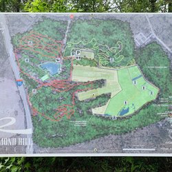
    Sterling Creek Park - Park map.

    Sterling Creek Park

    4.3(6 reviews)
    48.8 mi

    A great place to unwind! Beautiful lake & trails! Please mark trails & have a map of the area!read more

    Sterling Creek Park (SCP) is tucked away in the very back of a neighborhood called Sterling Creek…read morePlantation in Richmond Hill. You'll see signs to the park from Harris Trail Road when you turn in to the neighborhood. Keep going straight through the neighborhood until you get to the entrance to the park. SCP is the most unusual park that I have come across in this area, reason being that it shares space with the Police training grounds and gun range, as well as an active water treatment plant. See what I mean? That being said, I'll take trails and green space anywhere I can get it! - Background Info - There isn't too much info on this park online, but from what I could find, it seems that the city of Richmond Hill purchased this property back in 2012 with the intention of converting it into a park and the plan is to include running trails, nature trails, mountain bike paths, a fishing pond, restrooms, parking and camping. The property is about 187 acres of forests, wetlands, ponds, and grassland habitats. The most recent article I found was dated January of this year (2019) and it looks like they celebrated the opening of Phase 2 with a Relay Race. - Parking - Once you drive past the park entrance, just go straight until you get to a white-ish building. It looks like it's had better days and definitely does not look brand new. This building also has the restrooms (we didn't use them, so I don't know for sure, but the male/female signs are outside the doors) and the big space around it that seems to be the parking. - What we did - The Little One and I set out for a quick adventure, as we had to get back for her sister's event at school. We parked the car by the restrooms and behind it, you will see a large sign (the map of the park) and a trash can in the distance, by the woods, and that is where the beginning of the trail is. Now, keep in mind, don't go in the woods just yet right there, just walk alongside the fence of the water treatment plant, to the right. You will come to a dead end and there will be a well worn path into the woods which will be the only part in the forest). The path in the woods isn't very long and the day we went, it must have rained heavily there because part of the road was super muddy and there were tons of truck tracks. Once you get out of the woods and into the clearing, there is another well worn path/road that runs along the fence again of the water treatment plant. Walk down and keep walking down and don't lost hope, because you will finally get to the wetlands and ponds area. This area has more signs. I think we did parts of the yellow line and parts of the blue line (refer to pic). There is also a Youtube video that gives you a quick aerial view of the park to give you a general idea of what it is like. - My thoughts - The park is secluded, especially it being inside a neighborhood. I don't even think many of the residents of RH know about it. We saw one person along the trail, but at the same time, it was the weekday also. I read the article of the Relay Race that they held by the lake, after we walked the trail, and looking at the photos and videos posted online, I am still confused as to which lake they were running around, because it does not look anything close to the lakes and ponds we saw. I am going back to explore more when we have more time. All in all, the area is a bit confusing and I think they just need more signs at the beginning of the trail almost all the way until you pass the fencing of the water treatment plant. The presence of the water treatment plant gives you this sense that you shouldn't be there. The lake and ponds areas were my favorite part and they are clearly marked in that area, probably because it's the newest phase. I will update this review once I find the lake in the article!

    Photos
    Sterling Creek Park - Restrooms.

    Restrooms.

    Sterling Creek Park - Part of the trail in the forest. Just before you get out in the clearing, Super muddy there that day.

    Part of the trail in the forest. Just before you get out in the clearing, Super muddy there that day.

    Sterling Creek Park

    See all

    Dungannon Heritage Preserve - An alligator seen from the boardwalk

    Dungannon Heritage Preserve

    4.8(6 reviews)
    38.5 mi

    This is a beautiful nature preserve with several miles of trails through gorgeous woods and a…read morecypress swamp. We've found so many different birds here, including prothonotary warblers, northern parulas, hairy woodpeckers, and more. There is a boardwalk over a pond where wood storks nest - it's off limits a few months a year. It's a peaceful and quiet place to hike. I wish there were bathrooms though.

    Beautiful fall weather in Charleston, so decided to get some sunshine and fresh air while being one…read morewith nature at Dungannon Heritage nature preserve. The preserve is located off of SC highway #162 near Hollywood. Entrance to the preserve is free. This is a dog friendly park, so feel free to bring your fur babies! This is a beautiful park spanning 643- acres. There are several scenic trails that wander along the property. Bring your camera as there is a lot to see. The preserve has been set up to provide feeding and roosting areas for a variety of birds, Wood storks, Great Egrets and Blue Herons. You may also see alligators, deer and squirrels along the way. The trails are well maintained and clearly marked. There is not a restroom or picnic tables at this park. However, there is a gorgeous 300- foot boardwalk with an observation deck overlooking the swamp/pond. I had a picnic lunch here as I watched an alligator sun bathe and fish jump. It was so peaceful. If you are looking for a few hours to get back to nature and see beautiful views and some wildlife, you need to add Dungannon to your "Must See" list.

    Photos
    Dungannon Heritage Preserve - Breath taking view from the boardwalk

    Breath taking view from the boardwalk

    Dungannon Heritage Preserve
    Dungannon Heritage Preserve - Cedar swamp

    See all

    Cedar swamp

    Spanish Moss Trail - parks - Updated October 2026

    Loading...
    Loading...
    Loading...