Sleeping Bear Point Trail Photos


You might also consider
More like Sleeping Bear Point Trail
Recommended Reviews - Sleeping Bear Point Trail
Start your review...

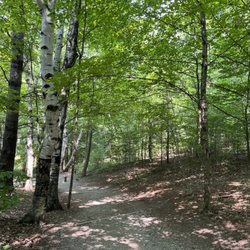
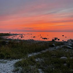
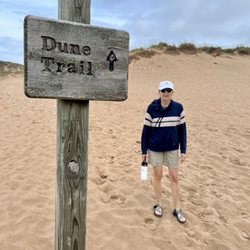
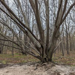
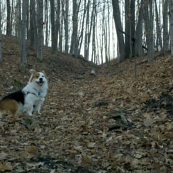
Great hike! Came here specifically hoping to get a glimpse of the nesting piper plovers in the area, and it did not disappoint! Afterwards, nice 2.8 mile loop that is a gentler dune hike than the classic dune trek to Lake Michigan, with some very nice views, a "ghost forest", much less people, and an ending that goes through a nice forested area. read more
More info about Sleeping Bear Point Trail


Sleeping Bear Point Trail - hiking - Updated August 2026
Best of Glen Arbor
People found Sleeping Bear Point Trail by searching for…
Hiking Trails in Glen Arbor, MI
Scenic Overlook in Glen Arbor, MI
Secret Spots in Glen Arbor, MI
Walking Trails in Glen Arbor, MI
Things to Do in Glen Arbor, MI
Lakes & Ponds in Glen Arbor, MI
Running Trails in Glen Arbor, MI
Dog Friendly Hiking Trails in Glen Arbor, MI
Playgrounds for Kids in Glen Arbor, MI
Swimming Lakes in Glen Arbor, MI
Things to Do on a Rainy Day in Glen Arbor, MI
Scenic Views in Glen Arbor, MI
Tent Camping in Glen Arbor, MI
Places to Take Pictures in Glen Arbor, MI
Lookout Points in Glen Arbor, MI
Trending Searches in Glen Arbor, MI
Blueberry Picking near Sleeping Bear Point Trail
Boating near Sleeping Bear Point Trail
Cinema near Sleeping Bear Point Trail
Day Trips near Sleeping Bear Point Trail
Dog Friendly Things To Do near Sleeping Bear Point Trail
Dog Swimming near Sleeping Bear Point Trail
Indoor Mini Golf near Sleeping Bear Point Trail
Jet Skis near Sleeping Bear Point Trail
Kayak Rental near Sleeping Bear Point Trail
Lakes near Sleeping Bear Point Trail
Outdoor Activities near Sleeping Bear Point Trail
Parks near Sleeping Bear Point Trail
Rainy Day Activities near Sleeping Bear Point Trail
River Tubing near Sleeping Bear Point Trail
Scenic Drive near Sleeping Bear Point Trail
Sunflower Field near Sleeping Bear Point Trail
Sunrise View near Sleeping Bear Point Trail
Surf Shop near Sleeping Bear Point Trail
Swimming Holes near Sleeping Bear Point Trail
Things To Do On A Rainy Day near Sleeping Bear Point Trail
Browse Articles
Browse Nearby
BEST of Glen Arbor, Michigan Restaurants near Sleeping Bear Point Trail
BEST of Glen Arbor, Michigan Coffee near Sleeping Bear Point Trail
BEST of Glen Arbor, Michigan Things to Do near Sleeping Bear Point Trail
BEST of Glen Arbor, Michigan Breakfast near Sleeping Bear Point Trail
BEST of Glen Arbor, Michigan Shopping near Sleeping Bear Point Trail
BEST of Glen Arbor, Michigan Wineries near Sleeping Bear Point Trail
Browse Brands
Related Searches in Glen Arbor, MI
Affordable Kayak Rental Services in Glen Arbor, Michigan
Affordable Paddle Board Rental in Glen Arbor, Michigan
Best Dog Hiking Trails Around Glen Arbor, Michigan
Best Fishing Locations and Guides in Glen Arbor, Michigan
Best Places for Horseback Riding in Glen Arbor, Michigan
Best Sightseeing Experiences Available in Glen Arbor, Michigan
Check Out Off Road Trails in Glen Arbor, Michigan
Discover Dog Friendly Trails to Explore in Glen Arbor, Michigan
Discover Popular Bike Trails in Glen Arbor, Michigan
Discover Top Boat Tours in Glen Arbor, Michigan for All Ages
Discover a Hiking Trail in Glen Arbor, Michigan
Discover the Best Beaches in Glen Arbor, Michigan
Discover the Best Night Hike Trails in Glen Arbor, Michigan
Dog-Friendly Hikes With Dogs in Glen Arbor, Michigan
Enjoy Camping Adventures Around Glen Arbor, Michigan
Enjoy Kayaking Adventures in Glen Arbor, Michigan
Enjoy Off Leash Dog Hikes in Glen Arbor, Michigan
Enjoy River Tubing Adventures in Glen Arbor, Michigan
Enjoy Tent Camping Spots Around Glen Arbor, Michigan
Enjoy the Best Walking Trails in Glen Arbor, Michigan
Explore Beautiful Parks and Green Spaces in Glen Arbor, Michigan
Explore Bike Rentals Throughout Glen Arbor, Michigan
Explore Easy Hikes Perfect for All in Glen Arbor, Michigan
Explore Fun Activities to Do in Glen Arbor, Michigan
Explore Popular Campgrounds Near Glen Arbor, Michigan
Explore Top Dog Parks in Glen Arbor, Michigan Near You
Explore the Best Beach Spots in Glen Arbor, Michigan
Family Friendly Hiking With Kids in Glen Arbor, Michigan
Find Cozy Camping Cabins in Glen Arbor, Michigan
Find Top Dog Friendly Parks to Visit in Glen Arbor, Michigan
Find the Best Playgrounds to Visit in Glen Arbor, Michigan
Must-See Tourist Attractions Around Glen Arbor, Michigan
Off Leash Dog Hiking Trails in Glen Arbor, Michigan
Plan a Scenic Drive Route Near Glen Arbor, Michigan
Popular Kids Activities in Glen Arbor, Michigan
Popular Outdoor Activities to Try in Glen Arbor, Michigan
Popular Picnic Spots to Visit in Glen Arbor, Michigan
Popular Things to Do in Glen Arbor, Michigan
Top Fishing Charter Experiences in Glen Arbor, Michigan
Top Hiking Trails to Explore in Glen Arbor, Michigan
Top Paddleboarding Activities in Glen Arbor, Michigan
Top RV Campgrounds to Visit in Glen Arbor, Michigan
Top Running Trails to Explore in Glen Arbor, Michigan
Top Swimming Lakes to Enjoy in Glen Arbor, Michigan
Top Things to Do With Kids in Glen Arbor, Michigan


