Silver Brook Trail Photos


You might also consider
More like Silver Brook Trail
Recommended Reviews - Silver Brook Trail
Start your review...

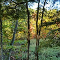
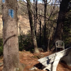
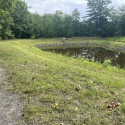
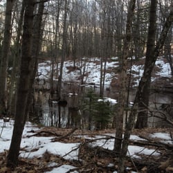
You know those magical places in the world that catch you off guard? You weren't expecting it, or looking for it maybe, you just stumbled upon it and thought... "this place - however long I stay here, whether I'm just passing through or stop to sit and soak it in - will always sit in my heart." That's how I felt about the brook off Broadturn Farm Trail. Broadturn Farm is this big, beautiful organic farm that invites visitors for a self-guided tour of the farmstead and their fields. Just behind their outhouses, though, lies Silver Brook Trail from the Scarborough Land Trust. It's maybe just a mile loop through former woods (really it feels like you're walking a wide path cut through enormous brambles). There's nothing exciting about it, but it's charming mostly because: a) You could be walking through the geography of a dozen different fables... will you end up at Snow White's cottage, the Shire, Albion, FernGully, or back at Broadturn Farm? b) There's a sign for a "Very Old Pine Tree" (and if that doesn't make you smile, then you're dead inside). Veer off the path to visit her. What IS so special about the place is... once you go down the little hill behind the outhouses you can choose to go right to the path or left to the brook. Go left. You will find yourself at a bench overlooking what I'm positive actually does come straight out of a fairy tale: if you're going in the summer, think hundreds of shades of green, moss covered rocks with water tumbling down them, a babbling brook, streams of golden sun shining through the canopy of trees. It feels absolutely enchanted or otherwordly (and I imagine it's just as glorious in the autumn). It's like a shot of everything perfect about nature right into the soul. And that it's just hidden-in-plain-sight enough, makes it feel extaordinarily special. read more


More info about Silver Brook Trail


Silver Brook Trail - hiking - Updated July 2026
Best of Scarborough
People found Silver Brook Trail by searching for…
Things to Do in Scarborough, Maine
Playgrounds in Scarborough, Maine
Hiking Trails in Scarborough, Maine
Things to Do on a Rainy Day in Scarborough, Maine
Attractions in Scarborough, Maine
Walking Trails in Scarborough, Maine
Secret Spots in Scarborough, Maine
Places to Take Pictures in Scarborough, Maine
Waterfalls in Scarborough, Maine
Swimming in Scarborough, Maine
Sunrise View in Scarborough, Maine
Sunset View in Scarborough, Maine
Lakes & Ponds in Scarborough, Maine
Swimming Lakes in Scarborough, Maine
Boardwalk in Scarborough, Maine
Waterfalls and Swimming Holes in Scarborough, Maine
Scenic Overlook in Scarborough, Maine
Photo Spots in Scarborough, Maine
Scenic View in Scarborough, Maine
Beautiful Views in Scarborough, Maine
Off Leash Dog Hiking Trails in Scarborough, Maine
Browse Articles
Browse Nearby
Browse Brands
Trending Searches in Scarborough, ME
Boat Rental near Silver Brook Trail
Cliff Jumping near Silver Brook Trail
Day Trips near Silver Brook Trail
Dog Friendly Trails near Silver Brook Trail
Fireworks near Silver Brook Trail
Jet Ski Rental near Silver Brook Trail
Kayak Rental near Silver Brook Trail
Lakes & Ponds near Silver Brook Trail
Off Road Trails near Silver Brook Trail
Outdoor Activities near Silver Brook Trail
Places To Swim near Silver Brook Trail
Pool Day Pass near Silver Brook Trail
Public Pools near Silver Brook Trail
Public Shower near Silver Brook Trail
River Swimming near Silver Brook Trail
Running Trails near Silver Brook Trail
Scenic Night View near Silver Brook Trail
Scenic Overlook near Silver Brook Trail
Secluded Spots near Silver Brook Trail
Soccer Store near Silver Brook Trail
Splash Pad near Silver Brook Trail
Strawberry Picking near Silver Brook Trail
Sunrise View near Silver Brook Trail
Swimming Holes near Silver Brook Trail
Swimming Lakes near Silver Brook Trail
Watch Sunset near Silver Brook Trail