There is, perhaps, no better way to truly appreciate urban life than riding down a bicycle path…read more There are many in SoCal--some nicer, some prettier, some cleaner--but none like this one. I have ridden the entire thing numerous times, both in sections and as a single long ride. Over time, you begin to notice themes and trends... When the flowers are in bloom, when the water runs in the river, when the clouds of gnats gather, and when the locals are active. There are times when it is scary, serene, scenic, scented, but always satisfying.
AZUSA CYN TO ARROW HIGHWAY:
Starting from the northernmost point, there is a turn-around dead-end where the trail enters Azusa canyon. Most folks don't start here, but for the purpose of explanation, this is the top of the trail. Nestled well in the foothills of the San Gabriels and adjacent to some upper end gated track housing, the trail here is relatively clean, save for the occasional pile of sand or gravel.
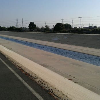
Heading south, the trail runs along the east side of the San Gabriel "river"-- an historic watershed that is largely concreted on its way to the ocean. This stretch is one of the more natural areas, with chaparral and semi-arid plants like yucca, sage, buckwheat, willow, prickly pear and cholla cactus growing amidst the rocky soil and Boulder-strewn expanse of the flat river bed. It is here that many enter the river trail at Lario or by parking near Encanto park and riding across the bridge.
This desert beauty, interrupted by the 210 freeway and the occasional kid on a big wheel, continues down past the Miller brewing plant into the Santa Fe Dam area (see my review for more information!)-- in summary, many recreational opportunities, a nature center or two, and a beautiful desert plant path to walk... Rabbits, roadrunners, coyotes, snakes, lizards, and ground squirrels frequent the area. The trail continues along the top of the dam for a couple of miles, then crosses Arrow Hwy.
ARROW HWY TO PICO RIVERA GOLF COURSE:
The trail switches to the west side of the river below Arrow Hwy. starting with one of several rest stops for bikers. This first one is a concrete area with some benches, a shaded area, and a map or two of the area. Heading south, the scene is mostly industrial for a mile or so. Passing behind neighborhoods and schools, the homeless population starts to show up under bridges and road overpasses. Graffiti becomes common. Occasional broken glass and garbage keeps your eyes on the path. There are a few places where it seems water collects most of the year; local subsistence fishermen ply the waters here for carp, and the occasional catfish or stocked trout that got trapped here when the waters recede seasonally. There are several horse and livestock properties along the last few miles above the Pico Rivera golf course/dam area. Watch for the roosters in cages-- I'm sure they're just part of a breeding program, and couldn't possibly be involved in any kind of cock fighting operation....
Just above the Pico dam, the SGR trail meets the terminus of the Rio Hondo trail, which heads essentially north back to Arcadia via Whittier Narrows regional park and past El Monte Airport.
Pico Rivera Golf Course is biker-friendly, and has restrooms, a snack bar, and a parking lot that seems to be used by many cyclists as an endpoint.
PICO RIVERA GOLF COURSE TO I-5 FWY
Just south of the golf course, you switch back to the east side of the river. This stretch prompted me to make a pepper spray purchase, and rig a holder for it in my handlebars. It is also good motivation to keep pedaling! Shoals of people-- some homeless, some harmless, and some homeys--wandering about or living under the bridges in communities. I once had a guy try to stop me holding a broomstick that I was sure was going in my front wheel as I sped by. If you time your ride when other cyclists are in the area or go with a group... And don't go looking for trouble... You just get through here. Backyard farms, horses, some illegal dumping, and urban rattle-can art highlight this stretch. Keep moving. Rest stops and small parks are overrun by homeless and weirdos. Respeto, Papi.
I-5 TO SEAL BEACH
As if someone hit a switch or waved a magic wand, the trail improves, and the scenery changes. Two big parks-- Wilderness Park and Liberty Park-- are decent rest stops with relative safety. Things continue to improve the closer you get to the ocean, but the crowds increase. Watch for kids, joggers, and pedestrians! Use your voice to let people know you're behind them.
Within a few miles of the beach, the river is filled with water year-round, and you can see mullet jumping out of the water near the power plant warm water outfalls. Anglers try to snag mullet and tilapia here. Numerous waterfowl and wading birds can be seen here. Prettier and prettier...
In Seal Beach, the last stretch heads down to the River's End cafe, and some beach restrooms, and a short ride to downtown and the pier.
Happy cycling!