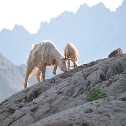
Salmon La Sac Campground Photos


More like Salmon La Sac Campground
Recommended Reviews - Salmon La Sac Campground
Start your review...

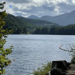
This was our first camping experience! We had heard there were some spots where you could just drive in and see if there was some camping space available, but since this was our first time we didn't really want to risk it and reseved spot 044 online through recreation.gov. When we got there our spot was ready to go! It was a great area right next to the creek so we had some amazing soothing sounds at night, the very clean restrooms were just a 3 minute walk away, and we had some lovely neighbors. One of the main things for us was: we needed working toilets, water, and a dog-friendly space. Salmon la Sac was a great fit in all of these areas. The one thing I'll say is our spot (044) was hit HARD by the sun most of the day, and since we went there in early August it got real hot real fast. The guys who were camping right next to us (I believe they must've been either 042 or 046) had literally the best spot since it still had the creek right in front of them, but they also were in a shaded area, so if you go there, try to get that one! read more


12 years ago
15 years ago
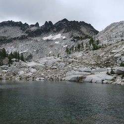
We love this campground, beautiful river, great hiking and breathtaking views. The only drawback is the configuration of the individual campsites. If you are camping with a camper, the sites are situated backwards. The campsite drive is angled so the front door of your camper faces the road, not your picnic table or fire pit. Plus the fire pits were set in so if you want to face the fire, your back is to the view, in our case the river and you are facing the road. I wonder who planned this campground. read more
10 years ago
9 years ago
9 years ago
More info about Salmon La Sac Campground
30160 Salmon La Sac Rd
Ronald, WA 98940
Directions
(509) 656-0366
Call Now
Hours
Outdoor Amenities
Ask the Community - Salmon La Sac Campground


Salmon La Sac Campground - hiking - Updated May 2026
Best of Ronald
People found Salmon La Sac Campground by searching for…
Trending Searches in Ronald, WA
Campgrounds near Salmon La Sac Campground
Cliff Jumping near Salmon La Sac Campground
Nurseries & Gardening near Salmon La Sac Campground
Parks near Salmon La Sac Campground
Party Equipment Rentals near Salmon La Sac Campground
Pedicure near Salmon La Sac Campground
Photo Spots near Salmon La Sac Campground
Places To Take Pictures near Salmon La Sac Campground
Spray Tanning near Salmon La Sac Campground
Browse Articles
Browse Nearby
Browse Brands
Related Searches in Ronald, WA
Affordable Jet Ski Rental Options in Ronald, Washington
Affordable Kayak Rental Services in Ronald, Washington
Best Fishing Locations and Guides in Ronald, Washington
Best Lookout Points to Visit in Ronald, Washington
Best Places for Horseback Riding in Ronald, Washington
Best Sledding Spots and Fun in Ronald, Washington
Discover Dog Friendly Trails to Explore in Ronald, Washington
Discover Top Boat Tours in Ronald, Washington for All Ages
Discover a Hiking Trail in Ronald, Washington
Discover the Best Night Hike Trails in Ronald, Washington
Dog-Friendly Hikes With Dogs in Ronald, Washington
Enjoy Camping Adventures Around Ronald, Washington
Enjoy Exciting Mountain Biking Adventures in Ronald, Washington
Enjoy the Best Tubing Experiences in Ronald, Washington
Enjoy the Best Walking Trails in Ronald, Washington
Exciting Cliff Jumping Spots in Ronald, Washington
Experience Thrilling White Water Rafting in Ronald, Washington
Explore Beautiful Parks and Green Spaces in Ronald, Washington
Explore Bike Rentals Throughout Ronald, Washington
Explore Easy Hikes Perfect for All in Ronald, Washington
Explore Family-Friendly Zoos and Wildlife in Ronald, Washington
Explore Free Things to Do Around Ronald, Washington
Explore Fun Activities to Do in Ronald, Washington
Explore Jet Skis for Sale or Rent in Ronald, Washington
Explore Popular Campgrounds Near Ronald, Washington
Explore Popular RV Parks Around Ronald, Washington
Explore Scenic Lakes to Visit in Ronald, Washington
Explore Top Dog Parks in Ronald, Washington Near You
Explore the Best Boating Spots in Ronald, Washington
Explore the Best Swimming Holes Around Ronald, Washington
Family Friendly Hiking With Kids in Ronald, Washington
Find Beautiful Views in Ronald, Washington
Find Popular Ziplining Spots Around Ronald, Washington
Find Top-Rated Disc Golf in Ronald, Washington
Find the Best Playgrounds to Visit in Ronald, Washington
Find the Best Swimming Pools in Ronald, Washington Today
Hiking Trails With Waterfalls in Ronald, Washington
Locate a Public Shower Facility in Ronald, Washington
Off Leash Dog Hiking Trails in Ronald, Washington
Perfect Spots to Watch Sunset in Ronald, Washington
Popular Kids Activities in Ronald, Washington
Popular Picnic Spots to Visit in Ronald, Washington
Popular Things to Do in Ronald, Washington
Relax at Natural Hot Springs Near Ronald, Washington
Top Climbing Spots and Gyms in Ronald, Washington
Top Paddleboarding Activities in Ronald, Washington
Top Swimming Lakes to Enjoy in Ronald, Washington
Top Things to Do With Kids in Ronald, Washington