Cancel

    Open app

    Search

    Ram Head Trail

    4.8 (8 reviews)

    Ram Head Trail Photos

    Recommended Reviews - Ram Head Trail

    Your trust is our priority, so businesses can't pay to alter or remove their reviews. Learn more about reviews.
    Yelp app icon
    Browse more easily on the app
    Review Feed Illustration

    Reviews With Photos

    Brian F.

    I hiked this trail with my older son. We went very early to avoid the heat. The trail was easy, a couple of challenging parts, but not difficult in any way. The views are amazing and well worth the drive out. Park at the salt pond parking lot but get there early because there are limited spots and you want to beat the full sun.

    Start here
    Jim R.

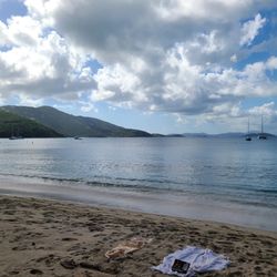
    A great hike with some unique scenery and beautiful vistas on the far end of the island. This is much more of a true hiking trail-uneven rocky terrain requiring good shoes. Things to know: -drive to far side of the island and park at the sign for salt pond beach -walk downhill across rocky ground to the nice beach -follow the beach all the way around to the trail -trail goes up and down over rocky ground but with proper shoes, anyone reasonably healthy can do it -arrive at cool beach with smooth blue rocks-skip a few stones and remember being 11 -go left following the beach until the end then just follow the trail up hill to the summit -this section is the steepest and quite rocky and of moderate difficulty -about 45-60 min up from the parking spot -great 360 degree views up on the windswept summit -much drier with lots of interesting cacti throughout -1-2 bottles of water per person should do it - consider a swim at the beach after as a reward -much of the trail is in the sun so plan accordingly Highly recommended

    Made it to the top!!
    Kat M.

    Wear a hat, make sure you have enough bug spray (if you are opposed to using DEET, you are cautioned! I started with some natural spray that didn't work at all, once I sprayed some Repel, I noticed a huge difference), bring a water bottle, and lather on the sunscreen! Fairly short hike, a little under 1.5 miles starting from the parking lot at Salt Pond. The beginning of the hike was moderately shaded through the trees and bush, but the mosquitos were terrible! They were swarming us all through the denser areas, then once we made it to Pebble beach, the hike became more open and the gets very hot as you get closer to the top. Parts of the hike are inclined enough to give you a good sweat, but nothing overbearing. You can count on direct sunlight for the latter part of your hike, but the view at the top is pretty remarkable and you get some solid wind flow up there that helps a lot! When you're finished drive over to Cruz Bay for a well deserved lunch!

    View of St. John's terrain from the end of the trail

    See all

    Photo of Lisa S.
    406
    1702
    5474

    4 months ago

    Helpful 2
    Thanks 0
    Love this 1
    Oh no 0

    1 year ago

    Helpful 0
    Thanks 0
    Love this 0
    Oh no 0
    Photo of Suzanne D.
    5
    116
    481

    3 years ago

    Helpful 1
    Thanks 1
    Love this 1
    Oh no 0

    3 years ago

    Helpful 1
    Thanks 0
    Love this 0
    Oh no 0
    Photo of Jim R.
    50
    1821
    5837

    9 years ago

    Helpful 2
    Thanks 0
    Love this 1
    Oh no 1
    Photo of Jess C.
    265
    1147
    851

    6 years ago

    Helpful 0
    Thanks 0
    Love this 1
    Oh no 0

    10 years ago

    Helpful 9
    Thanks 0
    Love this 5
    Oh no 0

    10 years ago

    Helpful 2
    Thanks 0
    Love this 0
    Oh no 0

    Verify this business for free

    Get access to customer & competitor insights.

    Verify this business

    Reef Bay Trail - Sugar mill ruins close to Reef Bay beach.

    Reef Bay Trail

    4.4(5 reviews)
    5.1 km

    One of the best hikes we did while in the Virgin Islands National Park. Absolutely beautiful, and…read morethe hike ends at some sugar mill ruins and a breath-taking beach. It's about a 5 mile round trip moderate hike - the way down isn't bad at all, but the way up can get pretty steep in places. Still completely doable, you'll probably just have to take some breaks during it. Make sure to bring water! And some snacks. You can take a detour off the main trail to see the petroglyphs - they're worth a see. If you're lucky, there might be a waterfall (we were hoping to see one, but no such luck when we were there). It can get pretty crowded there as it's a smaller space, so just a heads up. The beach at the bottom is very beautiful, but the beach is very rocky. We saw some people snorkeling there. A nice break before starting the hike back up. We got there around 10:30, and while the sun was up, you're hiking through jungle so there's pretty much always coverage from the sun. Surprisingly, it wasn't as crowded as we expected, and there's parking on the side of the road. Don't recommend getting here by taxi because it would be very difficult to get a ride back. Highly recommend this hike.

    2.5 miles down and 100 miles back. ;)…read more Our watch-app said 13,000 steps and close to 6 miles including exploring the petroglyphs and some of the beach area. We loved this hike. Native walls and ruins, the historic sugar mill, hermit crabs, giant spiders, land turtles, centipedes, beach mangroves, wasp nests and wild pineapple bushes. The trail is very well maintained by NPS conservatory groups and volunteers. Regarding the wasps - huge nests around the ruins - however they seem disinterested if you stay back / on trail and avoid rustling anything near them. It's interesting to note that while the beach here is very pretty -it's not the top highlight of the hike. The return hike definitely gets your attention and heart rate up, but while the trail is steep - most of the elevation challenge is within the last half-mile. Our total time with extensive exploration at petroglyphs, ruins, the beach plus reading each NPS description sign was a bit over 3 hours. Awesome hike!

    Photos
    Reef Bay Trail - Sign to the Petroglyph Trail spur off the main hiking path.

    Sign to the Petroglyph Trail spur off the main hiking path.

    Reef Bay Trail - Reef Bay Beach.

    Reef Bay Beach.

    Reef Bay Trail - The return is somewhat steeply hill for the last 1/3 of the trail.

    See all

    The return is somewhat steeply hill for the last 1/3 of the trail.

    Lind Point Trail - The Upper Lind Point Trail leads to various little secluded beaches in St. John.

    Lind Point Trail

    4.0(4 reviews)
    9.9 km

    The Lind Point Trail was just okay for me (well, sort of...). Yet...for anyone visiting St. John…read moreand Virgin Islands National Park, I at least highly recommend trekking up to the overlook. Beyond that....I found the trail to be mediocre. So....in all, I'd give 4 stars for the walk up to the overlook, and 3 stars the rest of the way. I had my rental car with me for exploring this island and the park. And...the start of the hike is located right behind the Virgin Islands Park Visitor's Center. Parking is pretty difficult overall while I ventured around. But, for this Lind Point Trail, there were literally 4 parking spaces available at the Visitor's Center where you can leave your car for a 1 hour time limit. I arrived early in the morning about 9am, and was fortunate enough to grab one of those spots. After venturing inside the Visitor's Center....I then hiked up the trail. Making my way to the overlook, it was simple. Yeah granted it's uphill, but the distance towards it was 1/3 of a mile. The Lind Point Overlook was great. It's a pleasant panoramic vista of all the town and island of Cruz Bay, St. John. I truly appreciated the views. Though....for me being a perfectionist, when I visited in morning during both days that I explored here, one morning the clouds were out in full force that tainted the clear blue waters of the bay, and the other morning I came here again and the sun faced right into my eyes in my direction while I peered out onto the waters. The surroundings were blinded by the light. Grrrr....so I never got the ideal photographs I was anticipating of beautiful Cruz Bay. I'd recommend to those out there who hike this trail....come on by in the afternoons! Yes...and hopefully when there's no clouds. Still, the views here were worth it and are the absolute highlight to this Lind Point Trail. Now...I did venture further along exploring the hike. There are 2 sections of the trail you can traverse. The Upper and Lower Trails. Yet....both lead exactly to the same spots around the island. So....there's really no difference either or which path you choose. I found out....might as well take the other Lower Lind Point Trail as it was shorter to gain access to the beaches. So....upon continuing past the overlook, I had researched ahead of time that Salomon and Honeymoon Beaches contained white sands and were quite picturesque. I was intrigued to find out if that was true. Yet though....upon arriving at both of these beaches, I was disappointed. One thing...from the overlook, it was maybe another third or half mile more to get to Salomon and Honeymoon Beaches. Not much more of a scamper. Both Salomon and Honeymoon Beaches were virtually identical. They were both real small, secluded and quiet. I was the only person on both beaches during my time there. And...although it may have been cloudy, I couldn't tell if there were white sands or not. Also, the waters certainly were not turquoise blue either. I honestly felt like visiting those two beaches were a waste of time. And now I understand why I was the only person among them. Because....they don't nearly hold a candle to the more famous and iconic Virgin Island beaches like Hawksnest, Trunk Bay and Cinnamon Bay. These recognizable areas absolutely had the magnificent and colorful waters. But, not Salomon or Honeymoon. They can be skipped. Also, this Lind Point Trail lead to Caneel Bay Beach, but since I was trekking all the way in the same area/general direction and I was letdown to begin with.....I actually skipped checking out Caneel Bay. Otherwise, there was really not much else to see on Lind Point Trail. Yeah...the trek around lead me through forest and lush tropical vegetation, but it wasn't anymore special whatsoever. Finally, my advice to tourists and travelers....at least make it to Lind Point Overlook and you'll then be okay to leave and continue on exploring the rest of St. John and Virgin Islands National Park. For me, from here I started my travels along North Shore Drive...(the main attraction road to get around)....where I ultimately continued along on my journey. If anyone cares to know, the only other short hike I'd recommend on the island is Peace Hill. Absolutely do this...another simple little saunter up a hill leading to wonderful scenery of the Trunk Bay waters.

    A great hike through the national park and/or a fun adventure to get to a couple beaches depending…read moreon how far you're willing to hike. A short walk from the ferry is the USVI National Park visitor center where you can find maps (and people) that point you to the beginning of the trail. Instead of taking a taxi for $6 per person, per way, I highly recommend hiking to several of the beaches instead! Solomon beach was the nearest beach and was about a 30 minute walk. Honeymoon beach is a bit further. You can wear flip flops since the terrain isn't awful, but I would recommend sneakers or sturdy sandals. How often do you get to hike to beautiful beaches, especially on vacation? Just do it. You won't regret it.

    Photos
    Lind Point Trail - There's even a Lower Lind Point Trail to hike but you're not afforded the observation scenery the Upper Trail provides.

    There's even a Lower Lind Point Trail to hike but you're not afforded the observation scenery the Upper Trail provides.

    Lind Point Trail - Trail signs and guide posts leading to all sorts of beaches in St. John.

    Trail signs and guide posts leading to all sorts of beaches in St. John.

    Lind Point Trail - Appreciating the scenery at Lind Point Overlook.

    See all

    Appreciating the scenery at Lind Point Overlook.

    Ham's Bluff Lighthouse

    Ham's Bluff Lighthouse

    4.3(6 reviews)
    62.1 km

    Ham's Bluff Lighthouse Trail is a fun and fairly easy hike. It's mostly uphill but manageable, and…read moreyou can complete it in about 20-25 minutes. Great option if you're looking for a quick hike with rewarding views at the top!"

    Calling all adventurers, calling all adventurers. This Lighthouse is an historic one that dates…read moreback to 1915, when the Island was under the rule of the Danish Government. It has severely deteriorated over the years, but is still a sight to see. The lighthouse is rusted out, has pieces that have fallen off and is severely corroded. Getting back to the lighthouse is slightly challenging. There are some huge potholes, which only get more challenging when it rains because they fill up with water and it becomes impossible to measure their depth. The closer you get to the lighthouse, the worse the road gets. There is tons of parking at the trail head located at the perimeter gate of the old abandoned National Guard complex. It is marked by a bright blue pallet. One thing to keep in mind is that this parking is known for vehicle break-ins, so do not leave any valuables in your vehicle Now the trail is all accent, heading towards the lighthouse. And there are some very steep points. I took me about 15 minutes to get up to the lighthouse. I would suggest wearing a hat and bringing some water with you on the hike, even though it is not long. It is very, very, very steep. The view from the lighthouse is very nice. It does get a little breezy up there, which I welcomed with open arms. You can go inside of the lighthouse and take two ladders up to the top. That was awesome. If you do that though, be very careful. The inside, including the stairs and floor, have corroded through and are very weak. They were strong enough to support my 250 pound frame, but I will admit, I was very scared. There are a few trails past the lighthouse that you can take to keep the party going. But I had no idea where they led and was not feeling dangerous that morning. Of course the way back was easier, since it was all down hill. But not as easy as I thought. I could imagine the trail being very tricky after a rain, making it very slippery and difficult to navigate both ways. This attraction has a lot to offer. You get a decent hill workout, you get some history, you get a miraculous view of the island's coast. I spent about 30 minutes at the lighthouse and enjoyed every minute of it. I highly recommend checking this site out.

    Photos
    Ham's Bluff Lighthouse
    Ham's Bluff Lighthouse
    Ham's Bluff Lighthouse

    See all

    Annaly Bay Tide Pools - Tree along trail

    Annaly Bay Tide Pools

    3.6(5 reviews)
    62.1 km

    The hike from Carambola was an adventure for sure. The initial steep climb up the hill is not for…read morethe faint of heart, but once you conquer that first incline, the trail becomes much more manageable. Keep your eyes sharp--there's an abundance of hermit snails along the way, a small reward for your effort. Be careful what you touch, though! I grabbed a tree and ended up with hairlike quills stuck in my hand for the rest of the afternoon--a small price to pay for the experience. Once the trail opens up, you're greeted by a stunning black stone beach. The waves are hypnotically relaxing, and the rocks seem to sing as the water flows back. The tide pools aren't the easiest to reach, requiring a bit of climbing over wet rocks, but the effort is more than worth it. This hike isn't just a walk--it's an adventure that leaves lasting memories.

    The pools are a series of large, naturally formed pools in a very secluded area on the island's…read moreNorth Shore. They are formed by waves and tide pushing seawater through a small crevice into a basin and trapping it there, thus forming swimming pool-sized tidal pool. But don't worry, the water is not stagnant. You can either walk here via a trail or drive there. Both are a bit challenging, but it is recommend to have an off road vehicle to drive there. I did not have one so, I would have to hoof it. I parked at the Carambola Beach Resort at started on my journey. They have a little area outside of the gate where you can park. The trail as a lot more arduous than I expected. There are some very, very steep inclines and declines, which become like ice after a rain. In some points it gets very narrow and overgrown. Some legs are right off of a step embankment and other have low hanging obstacles. The trail is not very well marked so be sure to take the one for walkers and not vehicles. I hear that it is a lot further. FYI, you do get an awesome view of the Resort along the trail. I recommend bringing a couple of bottles of water and some music, if you plan on making this trek. Also, good comfortable hiking shoes with some traction are a must. It took me about 40 minutes an I was at the pools. I was pretty beat when I got there and welcomed a dip in the nice cool water. Now I will apologize in advance, but here is my public service announcement. You will gain a respect for not only the pools beauty, but its power as well. Tide pools, especially this one are no joke. It can suck you into the ocean and good luck. You are at the mercy of the tides, who are undefeated. Water shoes are an absolute must here. The rocks in this area are like knives. You well definitely leave here with some little cuts. I got my hand and leg pretty good. They are also very uneven a slick, so, take your time. The final thing that I recommend is the buddy system. There were many times along the trail and in the pools, that I thought to myself that if something happened to me, no one would know for a long time. The way the trail is, it would be very difficult to get help to me. Vehicles can only get but so far near the pool area and boats would have a had time with the rocks and waves. If you don't have a buddy then at least let some one know where you are going and what time you plan on coming back. Don't get me wrong, this place is amazing. I was in aww of the waves crashing down, the clear water and the little pools. I highly recommend checking this place out, even though it may be difficult to do for many. I cannot stress enough that if you do visit, to please respect the water's power.

    Photos
    Annaly Bay Tide Pools - Taking a rest along the beach

    Taking a rest along the beach

    Annaly Bay Tide Pools - The start of our adventures

    The start of our adventures

    Annaly Bay Tide Pools - Easy walk so it starts

    See all

    Easy walk so it starts

    Cinnamon Bay Beach - Clean bathrooms!!

    Cinnamon Bay Beach

    4.9(60 reviews)
    7.8 km

    Such a BEAUTIFUL BEACH - highly recommended beach... also with a gift shop with souvenirs and…read moresnacks and more   - - -   June, 2025 Visit   - - -   Short Review,   Cinnamon Bay Beach...   ... has an island you can swim / snorkel to... many fish to see closer to the island   ... has a view of Great Thatch, British Virgin Islands   ... has indoor facilities... gift shop, snack bar (indoors and outside), campsites   ... not crowded       - - - Additional information: - - -   My wonderful wife planned a relaxing trip for us to St. John's, US Virgin Islands (just east of Puerto Rico), in June, 2025; we had a great time... such a beautiful island!     We snorkeled two beaches on St. John, and we enjoyed them both.   Cinnamon Bay Beach stuns you with its beautiful colors... the beach has light tan sand, helping make the water is a light green-blue color... stunningly beautiful!!     - - - Why Cinnamon Bay Beach - - -   Most of St. John is a National Park and most of the northern part of the island provides a nearly continuous beach... nearly continuous because peninsulas that extend into the water separate each beach from the other.    We looked at the map and read the reviews and picked Hawksnest and Cinnamon Bay beaches  because they looked more likely to have slightly smaller crowds, as cruise ships apparently visit other beaches (at least when we visited).  When we visited we were not alone and it was also not crowded.   Both are within a couple miles of each other, so while they are similar in overall look and feel - similar color of the water and sand, similar plants, etc., they are unique in what you can see underwater when you're snorkeling, and unique in the views from the beach.     - - - Taxis to and from - - -   To get to and from Cinnamon Bay Beach, you can drive or take a taxi.  The taxis on St. John, at least the ones we saw, are all trucks, with the driver in the cab, and the passengers sitting, open air, in the back... on benches with a roof over our heads.  The taxis run all day and will stop at multiple beaches to drop off and pick up passengers along the way.      - - - Cell / Mobile service - - -   Cell phone service is present, but the signal is a bit weak - 1 to 2 bars of signal strength.      - - - The beach - - -   Even if you never get in the water, the scene is beautiful... the water color is such a beautiful shade of blue...   Enya's "Caribbean Blue" (from 1991 album "Shepherd Moons") was playing in our heads, and was surely inspired by waters like these...   The sand is light and soft   Beautiful green trees and plants along the beach.     - - - The view from the beach - - -   Cinnamon Bay Beach is a beautiful beach and view of the British Virgin Islands' (BVI's) Jost Van Dyke in the distance and Great Thatch island closer... both BVI; St. John's Whistling Cay is visible, closer to the left, and Mary Point, closer to the right; Cinnamon Brach curbs east, and out into the water to a point that becomes Maho Bay and we stayed within Cinnamon Cay..     - - - The water... snorkeling - - -   On any given day, the water quality and aquatic life are things you cannot control.  The day we visited water quality and aquatic life were both goo -  the water was so clear and we saw so many fish, especially as we snorkeled out toward the island... which is much closer than it looks.. 5-10 minutes of calm to quicker leg kicking should get you there.     - - - Snorkeling - what we saw - - -   While snorkeling we were blessed to see: ⁃            a stingray swam by right as we started out !! ⁃            many more parrotfish-like blue-green-purplish fish and others ⁃            on the way back in, two squid!!     - - - Back on the beach - - -   We enjoy laying back and relaxing... and taking photos of our feet as they point toward the sand + surf... and we captured another one here on Cinnamon Bay Beach.   What a great afternoon!     - - - The surf, the lack of on St. John - - -   We have been blessed to visit the Caribbean a couple times and have noticed that there is not much surf, not many waves. On an early trip someone explained that the Caribbean is just at a position in the ocean that the rides are not small; brief internet searches suggest the tide only varies a few inches to a foot or so... such small changes don't lead to many waves. You'll likely see and enjoy hearing waves "lapping at the shore," but you're not likely to do much body surfing... if you have a boogie board, while you could bring it on your flight, you'll likely be better off leaving it at home. - - - Gift Shop - t-shirts, hat pins and more - - - - - - Thank you - - - Thank you to all the park team members who maintain Cinnamon Bay Beach, and to the taxi drivers getting us visitors to and from the beach! ----- ----- -----

    Full disclosure I didn't actually swim at this beach but I spent an hour or so here because it's…read moreactually a huge beach! The internet says it's one of the most famous ones and I can see why - the water is crystal clear, bright blue (as are most of the other national park beaches lol). It's spacious though, and in addition to the beach itself, there is a snack vendor area where you can buy lunch (like sandwiches and drinks), and a gear rental place for snorkeling etc. They also have a small restaurant adjacent to the campground cafeteria area which does breakfast and dinner (but not lunch). They have pretty clean bathrooms and showers too, and the most parking of all the beaches that I went to. They even had an info booth; the lady there was fairly knowledgeable about the park although I don't think she was an actual ranger (she wasn't in the ranger outfit). There's also a little area right at the entrance to the beach that is part of some ruins, it's a nice photo op spot. Overall this is a great beach! Def recommend.

    Photos
    Cinnamon Bay Beach - Beach

    Beach

    Cinnamon Bay Beach
    Cinnamon Bay Beach

    See all

    Ram Head Trail - hiking - Updated May 2026

    Loading...
    Loading...
    Loading...