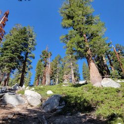
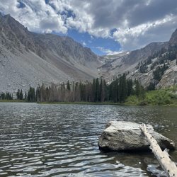
Pothole Dome Photos


 - Hiking Near Me")

You might also consider
More like Pothole Dome
Recommended Reviews - Pothole Dome
Start your review...

2 years ago


8 years ago
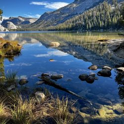
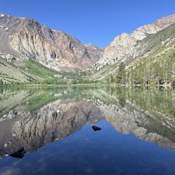
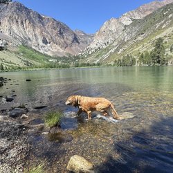
This is a fun hike for the family just outside of Tuolumne Meadows. You can park right next to the trailhead and even scramble up the dome if you're feeling the "vibe". Or you can walk around the meadows on the trail, which is what 98% of most people do. You can walk around to the lip and start to climb up the dome where you will be able to view the mountains, Tuolumne Meadows, and the Tuolumne River. As you reach the top of Pothole Dome, the scenery gets better and better. Picture time! If you keep hiking on the mountaintop (Northward) you can walk all the way to the top of another mountain, which is even taller and has better views. Most only hike to the top of Pothole Dome, but there are other mountains and areas to explore. You can even make your way down to the river. I will definitely do this again with family! read more
More info about Pothole Dome


Pothole Dome - hiking - Updated May 2026
Best of LEE VINING
People found Pothole Dome by searching for…
Parks in Lee Vining, California
Hiking Trails in Lee Vining, California
Redwood Trees in Lee Vining, California
Sunset View in Lee Vining, California
Things to Do in Lee Vining, California
Scenic Overlook in Lee Vining, California
Kids Fishing in Lee Vining, California
Dog Friendly Trails in Lee Vining, California
Trending Searches in LEE VINING, CA
Browse Articles
Browse Nearby
BEST of LEE VINING, California Horseback Riding near Pothole Dome
BEST of LEE VINING, California Restaurants near Pothole Dome
BEST of LEE VINING, California Campgrounds near Pothole Dome
BEST of LEE VINING, California Bike Rentals near Pothole Dome
BEST of LEE VINING, California Lunch near Pothole Dome
BEST of LEE VINING, California Hotels near Pothole Dome
Browse Brands
Related Searches in LEE VINING, CA
Affordable Kayak Rental Services in Lee Vining, California
Best Fishing Locations and Guides in Lee Vining, California
Best Nature Trails for Hiking in Lee Vining, California
Best Places for Horseback Riding in Lee Vining, California
Best Sledding Spots and Fun in Lee Vining, California
Discover Dog Friendly Trails to Explore in Lee Vining, California
Discover Popular Bike Trails in Lee Vining, California
Discover Scenic Mountain Bike Trails Near Lee Vining, California
Discover Scenic Waterfall Spots in Lee Vining, California
Discover Top Nature Parks to Visit in Lee Vining, California
Discover a Hiking Trail in Lee Vining, California
Discover the Best Night Hike Trails in Lee Vining, California
Dog-Friendly Hikes With Dogs in Lee Vining, California
Effective Stairs Workout Spots in Lee Vining, California
Enjoy Camping Adventures Around Lee Vining, California
Enjoy Kayaking Adventures in Lee Vining, California
Enjoy Tent Camping Spots Around Lee Vining, California
Enjoy the Best Tubing Experiences in Lee Vining, California
Enjoy the Best Walking Trails in Lee Vining, California
Exciting Cliff Jumping Spots in Lee Vining, California
Experience Thrilling White Water Rafting in Lee Vining, California
Explore Beautiful Parks and Green Spaces in Lee Vining, California
Explore Bike Rentals Throughout Lee Vining, California
Explore Easy Hikes Perfect for All in Lee Vining, California
Explore Fun Activities to Do in Lee Vining, California
Explore Popular Campgrounds Near Lee Vining, California
Explore Popular RV Parks Around Lee Vining, California
Explore Scenic Lakes to Visit in Lee Vining, California
Explore the Best Boating Spots in Lee Vining, California
Explore the Best Swimming Holes Around Lee Vining, California
Family Friendly Hiking With Kids in Lee Vining, California
Find Popular Ziplining Spots Around Lee Vining, California
Find the Best Parks for Picnics in Lee Vining, California
Find the Best Swimming Pools in Lee Vining, California Today
Hiking Trails With Waterfalls in Lee Vining, California
Locate a Public Shower Facility in Lee Vining, California
Must-See Tourist Attractions Around Lee Vining, California
Off Leash Dog Hiking Trails in Lee Vining, California
Plan a Scenic Drive Route Near Lee Vining, California
Popular Fishing Spots to Explore in Lee Vining, California
Popular Kids Activities in Lee Vining, California
Popular Outdoor Activities to Try in Lee Vining, California
Popular Picnic Spots to Visit in Lee Vining, California
Popular Things to Do in Lee Vining, California
Relax at Natural Hot Springs Near Lee Vining, California
Safe and Fun Parks for Kids in Lee Vining, California
Top Climbing Spots and Gyms in Lee Vining, California
Top Paddleboarding Activities in Lee Vining, California