Cancel

Open app

Search

Pettinger Point Trail

5.0 (1 review)

Pettinger Point Trail Photos

Recommended Reviews - Pettinger Point Trail

Your trust is our priority, so businesses can't pay to alter or remove their reviews. Learn more about reviews.
Yelp app icon
Browse more easily on the app
Review Feed Illustration
Photo of M C.
0
3
4

3 years ago

Helpful 1
Thanks 0
Love this 0
Oh no 0

Verify this business for free

Get access to customer & competitor insights.

Verify this business

Pacific Rim National Park Reserve

Pacific Rim National Park Reserve

4.9(7 reviews)
63.0 km

If you love nature, you will absolutely love coming here. It's worth the ferry ride and drive from…read moreVancouver. It's stunning, we did a few hikes, and they were all so different. They have the Forrest side, as well as the beach, so the variety of hikes are fantastic. Unfortunately we didn't have time to do the longer ones, but we were very satisfied with the ones we did. The boys enjoyed them, we didn't do hard ones, all were easy to moderate. We recommend the rainforest trail, radar hill (if it's clear), and south beach. I really recommend all if you have time.

If you are looking for the true West Coast Experience, this is it…read more The park consists of 3 Units: The Long Beach Unit 
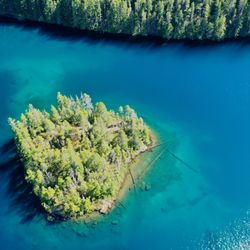
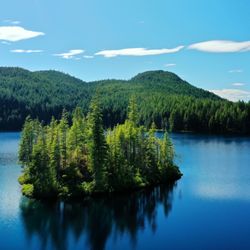
The Broken Islands Unit The West Coast Trail Unit I have been to the Long Beach and West Coast Trail units, and plan to one day kayak the Broken Islands. 
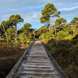
Long Beach is a popular spot for those going to Tofino or Ucluelet, and is a pretty amazing beach. Even if you aren't into surfing, just watching the waves roll in and strolling the sandy beach is worth the trip. 
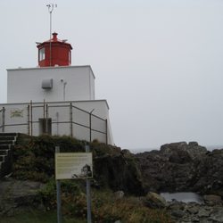
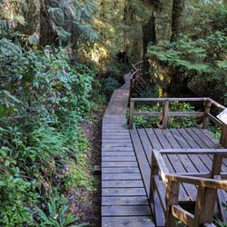
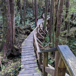
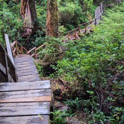
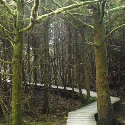
The West Coast Trail is a truly amazing experience. I have been twice now, and it's a tough, but rewarding right of passage. The trail is a 75 km trek across beach, up and down ladders, across rivers and trails through bog, forest and stunning scenery. Some people are so in love with the trail they do it every year. Despite the mud, roots, logs, and ladders! Or maybe because of them. It takes planning and money, though, so not for those who like to do things on a whim. The peak season is June 15th to September 15th, but the trail is open as early as May 1st and goes to September 30th. You won't ever catch me out there that early. I don't care if there are less people on the trail, the weather can be downright nasty! Reservations during the peak season are highly recommended, though there are limited spots available at each trail head for standby spots on the trail. The WCT is NOT for those with: A fear of heights Knee or back injuries Limited mobility Big egos and no experience Children accompanying The inability to clean up after themselves My only complaints about the WCT are the lack of info regarding parking areas at the trail heads, and ignorant people that do the trail with their kids (min age of 12 is still too young for this trail. 15 should be the minimum), or those who leave their garbage around (pack it in, pack it out, and burning your plastic food bags is not cool). Tips: Parking at the Pachena Bay trail head is not recommended, as there are many break-ins to vehicles that occur, despite being able to park on Parks Canada land. Parking in Port Renfrew for the Gordon River trail head is not on park land, and you either go to the Port Renfrew hotel in town, or the Gordon River Campground 1 min up the road from the trail head. This spot is also called Soft River (very confusing at 7:45 am). There are some places on the reserve (some guy's yard) that offer parking, too, but aren't open that early. Book the Trail Bus early to get to your trail head starting position. Park at the end you intend to finish, take the shuttle to your start. Hike back to your car. The shuttle picks up at the Port Renfrew Hotel (and trail head and Gordon River campground) and if you park there you can get a free ride back to your car from the trail head when you finish. This is your cheapest option. I parked at the Gordon River campground since it is closer to the trail head, not knowing you get the free ride back to the hotel. Despite being more expensive, it was safe. I accidentally left a window fully open, with all my friend's belongings in the trunk, and not a thing was touched. The bears didn't even take the half empty bag of Tostitos under the open window. Bonus! We ate these when we got back to the car.

Photos
Pacific Rim National Park Reserve - Carmanah Lighthouse

Carmanah Lighthouse

Pacific Rim National Park Reserve - Welcome sign at Gordon River

Welcome sign at Gordon River

Pacific Rim National Park Reserve

See all

Rainforest  Trail A & B

Rainforest Trail A & B

3.5(2 reviews)
15.7 km

Walked the trail this week (December/winter). Overall, a pretty cool hike composed of two loops…read moreunder a canopy of trees surrounded by ferns, bushes, and fallen tree trunks. Quick notes: -There are two loop trails (A & B), one on each side of the main road. -Parking and bathrooms (outhouse with no sink) are located on the route B side. -You do need to pay park admission (machines located in parking lot, paid less than $8 for one adult). -Each trail loop is about 1km. -The entire trail (besides the initial dirt path) is along a wooden boardwalk (about 2.5 ft wide). -On cold or rainy days, the wooden path can be slippery. I slipped numerous times, but luckily didn't fall. -It took me about 30 minutes to walk each loop (one hour total). I did walk a bit more slowly as the boardwalk was slippery. -While most of the trail is shaded, there are some parts where sun would shine through (bring sunglasses).

Among my favored trails in the Pacific Rim National Park, and one of few that doesn't end at a…read morebeach. It's nice and short (about 1km for each loop), a relatively easy hike, with many many beautiful things to look at throughout. The canopy also makes it a relatively drier hike in Tofino's generally wet weather. Loop A, on the east side of the highway, is a wooden boardwalk that meanders through a forest of primarily western red cedar and hemlock. This is also the older section of the forest. There are nurse logs (fallen trees with new trees growing on top of them) all over the place. Loop B, on the west side of the highway, is wooden boardwalk and stairs. Interpretive signs on the trail are full of all sorts of useful and interesting information. While the boardwalks are well-maintained, the only caution I have is that if the weather is rainy, the boardwalks can get a bit slippery, which can be a challenge for those with mobility issues. (I'd also imagine they can get icy in cooler weather.) Also, while they were quiet enough during our visit (April 2017,) they can get pretty busy during the high season, and the narrowness of the boardwalks makes passing other hikers a bit difficult.

Photos
Rainforest  Trail A & B

See all

Shorepine Bog Trail

Shorepine Bog Trail

4.0(2 reviews)
63.0 km

I couldn't believe it when I was one of the few people who was walking through this extremely…read moreamazing and unique bog trail. Everyone else was probably spending their time whale watching, beachcombing, or kayaking. Just think about it, who the heck would even imagine a bog in a wet and rainy place like Tofino? Shorepine Bog Trail is part of Pacific Rim National Park, so expect good things. The entire trail is made of a wooden boardwalk and it's circles around a 800 metre loop. Once I hit the trail, I was awed by the "Out of Africa" landscape. My brain was like, woah, where are the lions, tigers, and giraffes? Unfortunately, the only animals that roam this trail are cougars and bears and they were plenty of warning signs. While I was walking the boardwalk, I was surrounded by dwarfed and twisted trees. They were like big bonzai trees and my head was just spinning with confusion. I wasn't prepared to see anything like it in Tofino. Luckily, there were enough green covered trees and plants to make this trail very photo friendly. This trail is a GEM!

This trail is part of the Pacific Rim National Park so there is a fee for parking, but there is pay…read morestation in the parking lot. The trail that meanders via a continuous boardwalk for 0.8 km through an area that receives 300 cm, 118 inches, of rain per year. The bonsai-like shore pines in the bog grow only meters tall in century due to the acidity in the soil. We spotted a few warblers flitting from bush to bush. An enjoyable short walk for young and old.

Photos
Shorepine Bog Trail
Shorepine Bog Trail
Shorepine Bog Trail

See all

Pettinger Point Trail - hiking - Updated May 2026

Loading...
Loading...
Loading...