Perrine Coulee Falls Photos


More like Perrine Coulee Falls
Recommended Reviews - Perrine Coulee Falls
Start your review...

Reviews With Photos

After being somewhat disappointed with Shoshone Falls down canyon/river, I am thankful for a fellow Yelper who gave me a local insiders tip about this roadside attraction. When I say roadside, I'm being literal... Get to Canyon Springs Road going down into the Snake River Canyon toward Canyon Springs Golf Course and Centennial Waterfront Park. When you hit the first switchback in the road, pull off to the left side against the canyon wall where there's space for about seven vehicles. From the road's curved edge you can see Perrine Coulee Falls, however, I highly recommend you take the few feet climb down some rocks to access the very short trail that ventures behind the falls. It's spectacular and refreshing to be misted by the falls as it splashes over the canyon ledge while you can access it from underneath! If you can't get enough of this view, enjoy a meal at Redhawk Gastropub afterwards.

After viewing Shoshone Falls (which were in full flow, so quite spectacular to see), we visited Perrine Coulee for a chance to walk behind a waterfall. We loved it! We visited early on a Friday afternoon, arrived just as another group was leaving, and enjoyed 15 minutes of great views and refreshing mist behind a gorgeous waterfall. Another group arrived just as we left. The path to the falls is at the first switchback on the way down the road. It's an easy walk along the road up from the parking area at the second switchback, and a short walk from the opening at the rail to the waterfall.

When driving through the area on a road trip last week we wanted to check out Shoshone Falls. While researching it online I noticed Perrine Coulee and decided to find it too. Taking advice of a reviewer online, we chose to take in the falls from the paved rim trail behind the Canyon Crest Dining and Event Center. Great advice! The view from there was amazing...the Perrine Bridge and everything in the gorge below. The falls were pretty, from above we could see the parking below the falls, as well as the trail that leads you up to and behind the actual falls. Fun quick stop.

When in Twin Falls, everyone says to go to Shoshone Falls. We liked this waterfall so much more. It's not crowded here at all. There were only a couple other people around. Shoshone Falls is much more touristy/crowded. You can walk behind the falls which is awesome. You can also walk down and get great views of the bridge and even get a few of the waterfall from further away. This is a quick stop that's definitely worth making when in Twin Falls!

So beautiful!! We parked on the side of the road in the few parking spots available there. We walked less than a minute to the waterfall. It was so beautiful. Then we walked behind the waterfall as well. It was a simple walk all throughout but a bit rocky. Good view of the Perrine Bridge as well.

This is Twin Falls' only year-round waterfalls, and in my opinion it is far more spectacular than Shoshone Falls if it's not at peak water level. This waterfall is located just outside of town, only a two-minute drive or 10-minute hike from the commercial center of Twin Falls with hotels, shops, and restaurants. If you're staying in the area (most hotels are located around here), you absolutely should check it out! There is a scenic overlook on the drive to Centennial Park, but due to construction there is currently no parking allowed. But, if you park at the base of it, there's a gentle trail up the side of the Snake River Gorge that takes you right next to (and behind) Perrine Coulee Falls! Not to mention you get a great view of the canyon and the city's famous bridge. Or, there's a nice walking/biking trail above the falls that has a nice overlook spot too. If you're staying in Twin Falls, or just driving through and only have time to see one thing, make it this waterfall! A word of war

2 months ago
Amazing views from the trails and awesome asphalt trail. Definitely worth checking out !!! read more


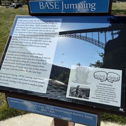
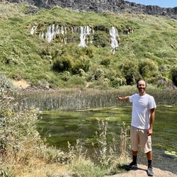
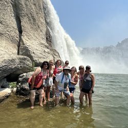
Wow!!! Perrine Coulee Falls is simply majestic. I can't rave about it enough! So cool. A natural wonder that is a sight to behold! Perrine Coulee Falls is located right in the heart of town in Twin Falls, Idaho. One afternoon I was grabbing lunch at McDonalds, and next I was driving 1 mile away and witnessing this 200 foot waterfall plunge. It's that easy. There are about 6 - 7 spaces for cars to pull off Canyon Springs Road to park. If they are all filled up, you can drive lower down the road near Twin Falls Waterfront Park and leave your car there and then walk back up to the waterfall. Once here, there's a circular pathway going around and underneath the falls. So, you have multiple opportunities from different angles to admire the views no matter where you may be standing. Perrine Coulee Falls splashes down into a corner of the Snake River Canyon. It's this tucked away waterfall, but on display for everyone to see, and free of charge. Looking up at the waterfall, it's like an action packed adrenaline punch hitting you in the face. The free fall drop can be inspiring. Extra Notes... - The waterfall flows year round but is more forceful in spring and summer times with snow melting. - There's nowhere to swim. - The backdrop looking away from the waterfall is impressive. There's a beautiful golf course located right beside the falls. In fact, while you're teeing off at one of the holes, you can easily view Perrine Coulee Falls. - Down at the base of Canyon Springs Road is Twin Falls Waterfront Park where you can do rafting, kayaking or paddle boarding along the Snake River. Also, Perrine Memorial Bridge is nearby where brave souls base jump, free fall and parachute down from the top of the 486 foot bridge. It's an incredible setting for getting a firsthand glimpse into base jumping. - You only need 20 - 25 minutes here at Perrine Coulee Falls. It's such a pleasant and easy stop. - I came on by at the end of July around 3pm and there were just a few people here. It never got too busy at any single moment and there was enough spacing between myself and others to grab undisturbed pictures. But, don't quote me on when people decide to visit, lol. Overall, what else can I say? If you are a waterfall enthusiast, you will love checking out Perrine Coulee Falls. And not only that, it's the entire state of Idaho. Not many people I know of explore this under the radar state, but there are some mighty dramatic waterfalls located throughout and if you have the time, you'll appreciate what the "potato state" has to offer :) read more


2 months ago
After being somewhat disappointed with Shoshone Falls down canyon/river, I am thankful for a fellow Yelper who gave me a local insiders tip about this roadside attraction. When I say roadside, I'm being literal... Get to Canyon Springs Road going down into the Snake River Canyon toward Canyon Springs Golf Course and Centennial Waterfront Park. When you hit the first switchback in the road, pull off to the left side against the canyon wall where there's space for about seven vehicles. From the road's curved edge you can see Perrine Coulee Falls, however, I highly recommend you take the few feet climb down some rocks to access the very short trail that ventures behind the falls. It's spectacular and refreshing to be misted by the falls as it splashes over the canyon ledge while you can access it from underneath! If you can't get enough of this view, enjoy a meal at Redhawk Gastropub afterwards. read more


4 years ago
After viewing Shoshone Falls (which were in full flow, so quite spectacular to see), we visited Perrine Coulee for a chance to walk behind a waterfall. We loved it! We visited early on a Friday afternoon, arrived just as another group was leaving, and enjoyed 15 minutes of great views and refreshing mist behind a gorgeous waterfall. Another group arrived just as we left. The path to the falls is at the first switchback on the way down the road. It's an easy walk along the road up from the parking area at the second switchback, and a short walk from the opening at the rail to the waterfall. read more


When driving through the area on a road trip last week we wanted to check out Shoshone Falls. While researching it online I noticed Perrine Coulee and decided to find it too. Taking advice of a reviewer online, we chose to take in the falls from the paved rim trail behind the Canyon Crest Dining and Event Center. Great advice! The view from there was amazing...the Perrine Bridge and everything in the gorge below. The falls were pretty, from above we could see the parking below the falls, as well as the trail that leads you up to and behind the actual falls. Fun quick stop. read more


5 years ago
When in Twin Falls, everyone says to go to Shoshone Falls. We liked this waterfall so much more. It's not crowded here at all. There were only a couple other people around. Shoshone Falls is much more touristy/crowded. You can walk behind the falls which is awesome. You can also walk down and get great views of the bridge and even get a few of the waterfall from further away. This is a quick stop that's definitely worth making when in Twin Falls! read more


So beautiful!! We parked on the side of the road in the few parking spots available there. We walked less than a minute to the waterfall. It was so beautiful. Then we walked behind the waterfall as well. It was a simple walk all throughout but a bit rocky. Good view of the Perrine Bridge as well. read more


This is Twin Falls' only year-round waterfalls, and in my opinion it is far more spectacular than Shoshone Falls if it's not at peak water level. This waterfall is located just outside of town, only a two-minute drive or 10-minute hike from the commercial center of Twin Falls with hotels, shops, and restaurants. If you're staying in the area (most hotels are located around here), you absolutely should check it out! There is a scenic overlook on the drive to Centennial Park, but due to construction there is currently no parking allowed. But, if you park at the base of it, there's a gentle trail up the side of the Snake River Gorge that takes you right next to (and behind) Perrine Coulee Falls! Not to mention you get a great view of the canyon and the city's famous bridge. Or, there's a nice walking/biking trail above the falls that has a nice overlook spot too. If you're staying in Twin Falls, or just driving through and only have time to see one thing, make it this waterfall! A word of war read more


3 years ago
5 years ago
Beautiful falls! Enjoyed the short hike up to the falls. It was fun to walk behind the falls and feel the mist from the falls. 5/5 would recommend. read more

More info about Perrine Coulee Falls
Canyon Springs Rd
Twin Falls, ID 83301
Directions
Hours
Outdoor Amenities
Ask the Community - Perrine Coulee Falls
Review Highlights - Perrine Coulee Falls


Perrine Coulee Falls - hiking - Updated July 2026
Best of Twin Falls
People found Perrine Coulee Falls by searching for…
Things to Do in Twin Falls, ID
Places to Take Pictures in Twin Falls, ID
Swimming Lakes in Twin Falls, ID
Beautiful Views in Twin Falls, ID
Natural Hot Springs in Twin Falls, ID
Hiking Trails in Twin Falls, ID
Restaurants With a View in Twin Falls, ID
Walking Trails in Twin Falls, ID
Fishing Spots in Twin Falls, ID
Tourist Attractions in Twin Falls, ID
Off Road Trails in Twin Falls, ID
Secret Spots in Twin Falls, ID
River Swimming in Twin Falls, ID
Scenic Views in Twin Falls, ID
Mountain Biking in Twin Falls, ID
Scenic Overlook in Twin Falls, ID
Trending Searches in Twin Falls, ID
Cliff Jumping near Perrine Coulee Falls
Day Trips near Perrine Coulee Falls
Dog Friendly Things To Do near Perrine Coulee Falls
Kayak Rental near Perrine Coulee Falls
Lakes near Perrine Coulee Falls
Public Shower near Perrine Coulee Falls
Public Swimming Pools near Perrine Coulee Falls
River Swimming near Perrine Coulee Falls
Swimming Holes near Perrine Coulee Falls
Browse Articles
Browse Nearby
BEST of Twin Falls, Idaho Coffee near Perrine Coulee Falls
BEST of Twin Falls, Idaho Things to Do near Perrine Coulee Falls
BEST of Twin Falls, Idaho Restaurants near Perrine Coulee Falls
BEST of Twin Falls, Idaho Parks near Perrine Coulee Falls
BEST of Twin Falls, Idaho Waterfalls near Perrine Coulee Falls
BEST of Twin Falls, Idaho Breakfast near Perrine Coulee Falls
BEST of Twin Falls, Idaho Visitor Centers near Perrine Coulee Falls
Browse Brands
Related Searches in Twin Falls, ID
Affordable Kayak Rental Services in Twin Falls, Idaho
Best Fishing Locations and Guides in Twin Falls, Idaho
Best Fun Things to Do in Twin Falls, Idaho
Best Places for Horseback Riding in Twin Falls, Idaho
Best Sightseeing Experiences Available in Twin Falls, Idaho
Check Out Off Road Trails in Twin Falls, Idaho
Discover Dog Friendly Trails to Explore in Twin Falls, Idaho
Discover a Hiking Trail in Twin Falls, Idaho
Discover the Best Beaches in Twin Falls, Idaho
Enjoy Camping Adventures Around Twin Falls, Idaho
Enjoy Kayaking Adventures in Twin Falls, Idaho
Enjoy Tent Camping Spots Around Twin Falls, Idaho
Experience Stunning Sunset Views in Twin Falls, Idaho
Explore Beautiful Parks and Green Spaces in Twin Falls, Idaho
Explore Free Things to Do Around Twin Falls, Idaho
Explore Fun Activities to Do in Twin Falls, Idaho
Explore Popular Campgrounds Near Twin Falls, Idaho
Explore Popular RV Parks Around Twin Falls, Idaho
Explore Popular Scenic Views Near Twin Falls, Idaho
Explore Scenic Lakes to Visit in Twin Falls, Idaho
Explore the Best Swimming Holes Around Twin Falls, Idaho
Family Friendly Hiking With Kids in Twin Falls, Idaho
Find Beautiful Views in Twin Falls, Idaho
Find Cozy Camping Cabins in Twin Falls, Idaho
Find Exciting Tours to Take in Twin Falls, Idaho
Find Fun Things to Do With Kids in Twin Falls, Idaho
Find Top-Rated Waterfalls in Twin Falls, Idaho Now
Find the Best Playgrounds to Visit in Twin Falls, Idaho
Must-See Tourist Attractions Around Twin Falls, Idaho
Perfect Spots to Watch Sunset in Twin Falls, Idaho
Popular Fishing Spots to Explore in Twin Falls, Idaho
Popular Kids Activities in Twin Falls, Idaho
Popular Outdoor Activities to Try in Twin Falls, Idaho
Popular Things to Do in Twin Falls, Idaho
Popular Things to See in Twin Falls, Idaho
Relax at Natural Hot Springs Near Twin Falls, Idaho
Safe River Swimming Areas in Twin Falls, Idaho
Safe and Fun Parks for Kids in Twin Falls, Idaho
Top Dog Friendly Things to Do in Twin Falls, Idaho
Top Hiking Trails to Explore in Twin Falls, Idaho
Top Paddleboarding Activities in Twin Falls, Idaho
Top Playgrounds for Kids to Enjoy in Twin Falls, Idaho
Top RV Campgrounds to Visit in Twin Falls, Idaho
Top Swimming Lakes to Enjoy in Twin Falls, Idaho
Top Swimming Spots and Pools in Twin Falls, Idaho
Top Things to Do With Kids in Twin Falls, Idaho
People who viewed Perrine Coulee Falls also viewed
Shoshone Falls Park
214 reviews
Earl M Hardy Box Canyon Springs Nature Preserve
3 reviews
Niagara Springs State Park
2 reviews
Malad Gorge State Park
10 reviews
Balanced Rock & Balanced Rock Park
7 reviews
Blue Heart Kayaking
16 reviews
Perrine Memorial Bridge
8 reviews
Miracle Hot Springs
84 reviews
$
Bearded Axe
6 reviews
Twin Falls Escape Rooms
11 reviews