Balanced Rock & Balanced Rock Park Photos


More like Balanced Rock & Balanced Rock Park
Recommended Reviews - Balanced Rock & Balanced Rock Park
Start your review...

Reviews With Photos

OK, at first I thought "there is one I can miss." when I was told about the things to see around Twin Falls. I am glad I went during the spring of 2020 as there was little else to do in Twin Falls during quarantine. The drive out is rural farming roads that are as flat as can be and just when you start to think "where is this rock at?" You turn one corner and drop down into a canyon. In the canyon is not just the rock, but beauty that resembles the canyons of the Grand Canyon, a charming day use park, a stream, people fishing, and hills to ride ATV's in. The hike to the rock is steep and requires good shoe traction. It just take 15-20 minutes to climb to where you can touch the rock. Only 10 minutes to slide down. The rock is quite amazing up close up.

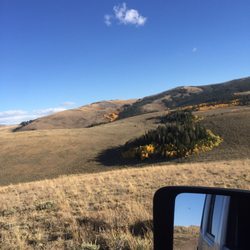
Great place for hiking and adventure. This place is in the middle of nowhere! You will pass through small farm towns and see nothing but farmlands, but if you continue to smell cow and sheep poop, soured milk and see cornfields; you're going the right way. I enjoyed the smells and ride finding this place! Great ride to explore!


1 year ago
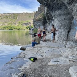
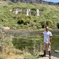
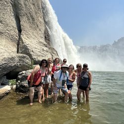
This park is such a hidden gem! On the hunt for balanced rock, we drove right past the park without even seeing it. Luckily we spotted it on the drive out. It's a quiet, gem in the bottom of a canyon with shaded (and not) picnic and camping areas along a flowing stream. It was beautiful, grassy, with bathrooms, bbq's, fire pits, swings, and ample nature surrounding you. According to Google, this area is open 24/7 and camping is free. The signs posted say max 7 days. This would be a perfect place for a picnic or relaxed afternoon to hang out with your family, Just be prepared that there is no cell phone reception. Satellite was available intermittently. If nothing else, it's worth the drive out here to soak in the beautiful views and spot a few yellow bellied marmots. read more


7 months ago
Loved it! The beauty, mystery of Balanced Rock is awe inspiring! It's a must see! Welcome to Southern Idaho! Gods Country read more


1 year ago
Really cool spot to stop by and hike up to! Small hike and totally worth it! What a beautiful view too. read more


OK, at first I thought "there is one I can miss." when I was told about the things to see around Twin Falls. I am glad I went during the spring of 2020 as there was little else to do in Twin Falls during quarantine. The drive out is rural farming roads that are as flat as can be and just when you start to think "where is this rock at?" You turn one corner and drop down into a canyon. In the canyon is not just the rock, but beauty that resembles the canyons of the Grand Canyon, a charming day use park, a stream, people fishing, and hills to ride ATV's in. The hike to the rock is steep and requires good shoe traction. It just take 15-20 minutes to climb to where you can touch the rock. Only 10 minutes to slide down. The rock is quite amazing up close up. read more


8 years ago
Great place for hiking and adventure. This place is in the middle of nowhere! You will pass through small farm towns and see nothing but farmlands, but if you continue to smell cow and sheep poop, soured milk and see cornfields; you're going the right way. I enjoyed the smells and ride finding this place! Great ride to explore! read more


7 years ago
The little trailer had just been groomed prior to our visit. A good easy little hike with kids up to the rock with nice views. There are port-a-potty's in the parking area. A bit of a drive and not for those who are looking for a challenging climb but we enjoyed our visit. read more


7 years ago
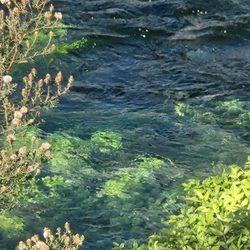
We stopped here to camp for the night, and it was great for what it is. A small little park in a canyon that follows a stream. It has shade shelters, picnic tables, grills, pit toilets and swing sets. It is a great free place to camp or a great place to have a Bar-B-Que. read more


More info about Balanced Rock & Balanced Rock Park
Ask the Community - Balanced Rock & Balanced Rock Park


Balanced Rock & Balanced Rock Park - hiking - Updated May 2026
Best of Buhl
Browse Brands
Related Searches in Buhl, ID
Best Fishing Locations and Guides in Buhl, Idaho
Best Fun Things to Do in Buhl, Idaho
Best Places for Horseback Riding in Buhl, Idaho
Enjoy Kayaking Adventures in Buhl, Idaho
Enjoy Tent Camping Spots Around Buhl, Idaho
Enjoy the Best Family Activities in Buhl, Idaho
Enjoy the Best Picnic Spots and Ideas in Buhl, Idaho
Explore Beautiful Parks and Green Spaces in Buhl, Idaho
Explore Popular Campgrounds Near Buhl, Idaho
Explore Popular RV Parks Around Buhl, Idaho
Explore Scenic Lakes to Visit in Buhl, Idaho
Find Beautiful Views in Buhl, Idaho
Find Cozy Camping Cabins in Buhl, Idaho
Find the Best Playgrounds to Visit in Buhl, Idaho
Must-See Tourist Attractions Around Buhl, Idaho
Popular Kids Activities in Buhl, Idaho
Popular Outdoor Activities to Try in Buhl, Idaho
Popular Places to Take Pictures in Buhl, Idaho
Popular Things to Do in Buhl, Idaho
Popular Things to See in Buhl, Idaho
Relax at Natural Hot Springs Near Buhl, Idaho
Browse Articles
People found Balanced Rock & Balanced Rock Park by searching for…
Trending Searches in Buhl, ID
Campgrounds near Balanced Rock & Balanced Rock Park
Cliff Jumping near Balanced Rock & Balanced Rock Park
Dog Friendly Things To Do near Balanced Rock & Balanced Rock Park
Floral Designers near Balanced Rock & Balanced Rock Park
Flower Shop near Balanced Rock & Balanced Rock Park
Garden Center near Balanced Rock & Balanced Rock Park
Hair near Balanced Rock & Balanced Rock Park
Nurseries & Gardening near Balanced Rock & Balanced Rock Park
Outdoor Furniture Stores near Balanced Rock & Balanced Rock Park
Party Equipment Rentals near Balanced Rock & Balanced Rock Park
Pedicure near Balanced Rock & Balanced Rock Park
Picnic Areas near Balanced Rock & Balanced Rock Park
Places To Take Pictures near Balanced Rock & Balanced Rock Park