Opossum Lake Photos


More like Opossum Lake
Recommended Reviews - Opossum Lake
Start your review...

5 months ago
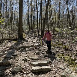
'Possum Lake is a great place to go for a quick hike or paddle. My favorite thing is to hike around the lake in the evening then head out in the kayak. The distance around the lake is, I think, about 3 or 3 1/2 miles and there are some small hills, steps, and mostly dirt or pine-needle-covered terrain. In terms of kayaking, I can paddle around all areas in about an hour. It's a convenient, easy-to-get-to location and it's open until 10pm. read more


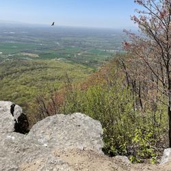
We sat by the lake and walked along the water, taking in the beautiful mountain views. Families were enjoying the playground with their kids and having picnics under the available shelters. The lake itself was amazing, perfect for fishing, swimming, and boating. The surrounding trails offered a great way to fully enjoy the outdoors. read more

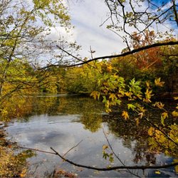
Opossum Lake is a 59 acres lake owned by the Pennsylvania Fish & Boat Commission. It is a great spot for kayaking, fishing and picnicng. Theres a nice new playground and several pavilliond and a walking path that has the be at leat 2 miles ling. A favorite of oue families. We plan to spend much more time here. Ample parking, multiple launches. read more


More info about Opossum Lake


Why does Yelp recommend reviews?
1 review that is not currently recommended
The reviews below are not factored into the business's overall star rating.
7 years ago
Opossum Lake - hiking - Updated May 2026
Best of Carlisle
People found Opossum Lake by searching for…
Swimming Lakes in Carlisle, PA
Fun Things to Do in Carlisle, PA
Scenic Overlook in Carlisle, PA
Walking Trails in Carlisle, PA
Beautiful Views in Carlisle, PA
Free Things to Do in Carlisle, PA
Running Trails in Carlisle, PA
Fishing With Kids in Carlisle, PA
Crabbing Location in Carlisle, PA
Trending Searches in Carlisle, PA
Botanical Gardens near Opossum Lake
Bounce House Rentals near Opossum Lake
Canoe Rental near Opossum Lake
Cheap Plants near Opossum Lake
Cherry Picking near Opossum Lake
Cliff Jumping near Opossum Lake
Dinner Cruise near Opossum Lake
Fishing Ponds near Opossum Lake
Flower Fields near Opossum Lake
Garage Sales near Opossum Lake
Garden Center near Opossum Lake
Lakes & Ponds near Opossum Lake
Nurseries & Gardening near Opossum Lake
Outdoor Activities near Opossum Lake
Outdoor Furniture Stores near Opossum Lake
Party Equipment Rentals near Opossum Lake
Picnic Areas near Opossum Lake
Picnic Spots near Opossum Lake
Places To Take Pictures near Opossum Lake
Pontoon Boat Rentals near Opossum Lake
Running Trails near Opossum Lake
Scenic Drive near Opossum Lake
Sunrise View near Opossum Lake
Swimming Holes near Opossum Lake
Table And Chair Rentals near Opossum Lake
Browse Nearby
Browse Brands
Related Searches in Carlisle, PA
Affordable Canoe Rental Options in Carlisle, Pennsylvania
Affordable Fishing Rental Services in Carlisle, Pennsylvania
Best Boat Launch Spots in Carlisle, Pennsylvania
Best Fishing Locations and Guides in Carlisle, Pennsylvania
Best Fun Things to Do in Carlisle, Pennsylvania
Best Places for Horseback Riding in Carlisle, Pennsylvania
Best Pontoon Boat Rentals Near Carlisle, Pennsylvania
Best Sightseeing Experiences Available in Carlisle, Pennsylvania
Best Spots for Star Gazing in Carlisle, Pennsylvania
Best Waterfalls and Swimming Holes in Carlisle, Pennsylvania
Book Top Fishing Trips in Carlisle, Pennsylvania Today
Check Out Off Road Trails in Carlisle, Pennsylvania
Discover Dog Friendly Trails to Explore in Carlisle, Pennsylvania
Discover Fun Activities to Do in Carlisle, Pennsylvania
Discover Lakes & Ponds to Explore in Carlisle, Pennsylvania
Discover Scenic Mountain Bike Trails Near Carlisle, Pennsylvania
Discover Top Boat Tours in Carlisle, Pennsylvania for All Ages
Discover Top Nature Parks to Visit in Carlisle, Pennsylvania
Discover a Hiking Trail in Carlisle, Pennsylvania
Discover the Best Fishing Lake in Carlisle, Pennsylvania
Discover the Best Kayak Tour Options in Carlisle, Pennsylvania
Discover the Best Night Hike Trails in Carlisle, Pennsylvania
Dog-Friendly Hikes With Dogs in Carlisle, Pennsylvania
Enjoy Camping Adventures Around Carlisle, Pennsylvania
Enjoy Exciting Mountain Biking Adventures in Carlisle, Pennsylvania
Enjoy Fishing Pier Spots in Carlisle, Pennsylvania With Scenic Views
Enjoy Fishing With Kids in Carlisle, Pennsylvania Safely
Enjoy Hiking Adventures in Carlisle, Pennsylvania
Enjoy River Tubing Adventures in Carlisle, Pennsylvania
Enjoy Sailing Adventures in Carlisle, Pennsylvania
Enjoy Scenic River Cruises in Carlisle, Pennsylvania
Enjoy Tent Camping Spots Around Carlisle, Pennsylvania
Enjoy a Beautiful Waterfall Hike in Carlisle, Pennsylvania
Enjoy the Best Family Activities in Carlisle, Pennsylvania
Enjoy the Best Tubing Experiences in Carlisle, Pennsylvania
Enjoy the Best Walking Trails in Carlisle, Pennsylvania
Exciting Cliff Jumping Spots in Carlisle, Pennsylvania
Experience Amazing Scuba Diving in Carlisle, Pennsylvania
Experience Thrilling Rafting Adventures in Carlisle, Pennsylvania
Experience Thrilling White Water Rafting in Carlisle, Pennsylvania
Explore Beautiful Parks and Green Spaces in Carlisle, Pennsylvania
Explore Bike Rentals Throughout Carlisle, Pennsylvania
Explore Fun Activities to Do in Carlisle, Pennsylvania
Explore Popular Boat Charters Near Carlisle, Pennsylvania
Explore Popular Campgrounds Near Carlisle, Pennsylvania
Explore Popular Day Trips From Carlisle, Pennsylvania
Explore Popular Picnic Areas Around Carlisle, Pennsylvania
Explore Popular RV Parks Around Carlisle, Pennsylvania
Explore Popular Scenic Overlook Points in Carlisle, Pennsylvania