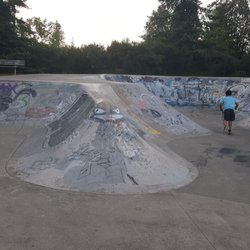
Old Mill Park Photos


You might also consider
More like Old Mill Park
Recommended Reviews - Old Mill Park
Start your review...

4 years ago
My wife and I are retired. We like to walk, and yesterday, visited Old Mill Park. We were horrified to find a homeless camp, just out of sight of the road. We felt unsafe, and left immediately. According to Lindsey from Utah, homeless took over this park at least three months ago. People visiting from out of state are getting a bad impression of our community, as am I. The rules clearly state closed at sunset. We would appreciate it if the Parks Department would enforce the rules, so we could enjoy the park we are paying for. read more


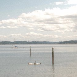
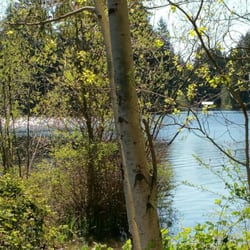
Cute little park! Its not a destination park but offers a little information about the history of Silverdale and about waterfront environment. A nice little spot for a picnic. Its connects up with Clear Creek Trail & offers great views of the Sound. Overall score 3.5 / 5.0 read more


4 years ago
5 years ago
More info about Old Mill Park
You might also consider


Old Mill Park - parks - Updated July 2026
Best of Silverdale
People found Old Mill Park by searching for…
Fun Things to Do in Silverdale, Washington
Things to Do With Kids in Silverdale, Washington
Watch Sunset in Silverdale, Washington
Walking Trails in Silverdale, Washington
Campgrounds in Silverdale, Washington
Hiking Trails in Silverdale, Washington
View Points in Silverdale, Washington
Scenic Drive in Silverdale, Washington
Playgrounds in Silverdale, Washington
Free Things to Do in Silverdale, Washington
Secret Spots in Silverdale, Washington
Running Tracks Open to the Public in Silverdale, Washington
Places to Take Pictures in Silverdale, Washington
Parks for Kids in Silverdale, Washington
Beautiful Views in Silverdale, Washington
Things to Do at Night in Silverdale, Washington
Running Trails in Silverdale, Washington
Dog Friendly Places in Silverdale, Washington
Dog Friendly Hiking Trails in Silverdale, Washington
Picnic Areas in Silverdale, Washington
Scenic Views in Silverdale, Washington
Swimming Lakes in Silverdale, Washington
Trending Searches in Silverdale, WA
4th Of July Fireworks in Silverdale, WA
Baseball Fields in Silverdale, WA
Black Owned Nail Salons in Silverdale, WA
Cliff Jumping in Silverdale, WA
Dog Friendly Beaches in Silverdale, WA
Dog Friendly Trails in Silverdale, WA
Fishing Spots in Silverdale, WA
Jet Ski Rental in Silverdale, WA
Kayak Rental in Silverdale, WA
Kids Activities Outdoor in Silverdale, WA
Lakes & Ponds in Silverdale, WA
Outdoor Activities in Silverdale, WA
Outdoor Basketball Courts in Silverdale, WA
Parks For Picnics in Silverdale, WA
Places To Walk Around in Silverdale, WA
Public Beaches in Silverdale, WA
Public Pools in Silverdale, WA
Public Shower in Silverdale, WA
River Swimming in Silverdale, WA
Scenic Night View in Silverdale, WA
Scenic Overlook in Silverdale, WA
Secluded Spots in Silverdale, WA
Soccer Store in Silverdale, WA
Strawberry Picking in Silverdale, WA
Sunrise View in Silverdale, WA
Swimming Holes in Silverdale, WA
Swimming Lakes in Silverdale, WA
Things To Do With Kids in Silverdale, WA
Watch Sunset in Silverdale, WA
Browse Nearby
BEST of Silverdale, Washington Coffee near Old Mill Park
BEST of Silverdale, Washington Things to Do near Old Mill Park
BEST of Silverdale, Washington Restaurants near Old Mill Park
BEST of Silverdale, Washington Breakfast near Old Mill Park
BEST of Silverdale, Washington Playgrounds near Old Mill Park
BEST of Silverdale, Washington Picnic Areas near Old Mill Park
BEST of Silverdale, Washington Campgrounds near Old Mill Park
BEST of Silverdale, Washington Star Gazing near Old Mill Park
Browse Brands
Related Searches in Silverdale, WA
Affordable Kayak Rental Services in Silverdale, Washington
Best Fishing Locations and Guides in Silverdale, Washington
Best Off Leash Dog Parks in Silverdale, Washington
Best Parks for Parties and Events in Silverdale, Washington
Best Places for Horseback Riding in Silverdale, Washington
Best Water Parks for Kids in Silverdale, Washington
Best Waterfalls and Swimming Holes in Silverdale, Washington
Check Out Great Playgrounds in Silverdale, Washington
Check Out Off Road Trails in Silverdale, Washington
Discover Baseball Fields Around Silverdale, Washington
Discover Beautiful Garden Spots in Silverdale, Washington
Discover Dog Friendly Trails to Explore in Silverdale, Washington
Discover Fun Toddler Parks in Silverdale, Washington for Your Little One
Discover Lakes & Ponds to Explore in Silverdale, Washington
Discover Popular Photo Spots in Silverdale, Washington
Discover Public Beaches to Visit in Silverdale, Washington
Discover Scenic Mountain Bike Trails Near Silverdale, Washington
Discover Scenic Waterfall Spots in Silverdale, Washington
Discover Soccer Fields in Silverdale, Washington Near You
Discover Top Nature Parks to Visit in Silverdale, Washington
Discover Top State Parks to Visit in Silverdale, Washington
Discover Walking Parks in Silverdale, Washington Near You
Discover a Hiking Trail in Silverdale, Washington
Discover the Best Beaches in Silverdale, Washington
Discover the Best Kids Park Spots in Silverdale, Washington
Discover the Best Night Hike Trails in Silverdale, Washington
Dog-Friendly Hikes With Dogs in Silverdale, Washington
Enjoy Camping Adventures Around Silverdale, Washington
Enjoy Exciting Mountain Biking Adventures in Silverdale, Washington
Enjoy Kayaking Adventures in Silverdale, Washington
Enjoy Tent Camping Spots Around Silverdale, Washington
Enjoy a Beautiful Waterfall Hike in Silverdale, Washington
Enjoy the Best Picnic Spots and Ideas in Silverdale, Washington
Enjoy the Best Walking Path in Silverdale, Washington
Enjoy the Best Walking Trails in Silverdale, Washington
Experience Thrilling White Water Rafting in Silverdale, Washington
Explore Beautiful Botanical Gardens in Silverdale, Washington
Explore Beautiful Parks and Green Spaces in Silverdale, Washington
Explore Easy Hikes Perfect for All in Silverdale, Washington
Explore Family-Friendly Zoos and Wildlife in Silverdale, Washington
Explore Free Picnic Areas Around Silverdale, Washington
Explore Fun Activities to Do in Silverdale, Washington
Explore Parks With Pull Up Bars in Silverdale, Washington
Explore Popular Campgrounds Near Silverdale, Washington
Explore Popular Picnic Areas Around Silverdale, Washington
Explore Popular RV Parks Around Silverdale, Washington
Explore Scenic Lakes to Visit in Silverdale, Washington
Explore Top Dog Parks in Silverdale, Washington Near You