Oak Hill Park Photos


You might also consider
More like Oak Hill Park
Recommended Reviews - Oak Hill Park
Start your review...

11 years ago
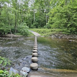
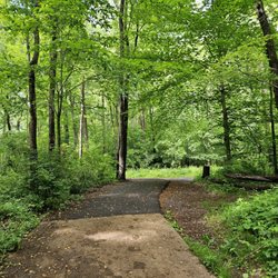
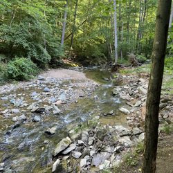
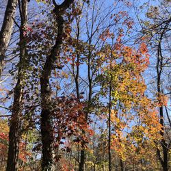
Oak Hill Park is a neighborhood park and best accessed by bike or on foot from the parking lot at nearby Canterbury Woods Park, Howery Field Park or Wakefield Park. Oak Hill Park is named for Historic Oak Hill Mansion which is less than half a mile away. Oak Hill Mansion was saved from being bulldozed by a developer during the 2005 housing boom. Oak Hill Park was overgrown and fell off the radar for years until local residents like yourself volunteered to become stewards of the park. To volunteer or report issues please contact Fairfax County Park Authority at 703-324-8591 or Friends of Accotink Creek. http://patch.com/virginia/annandale/historic-oak-hill-property-opens-its-doors-public-0 http://www.washingtonpost.com/wp-dyn/content/article/2006/03/30/AR2006033002339.html read more


More info about Oak Hill Park
4939 Tarheel Way
Annandale, VA 22003
Directions
(703) 324-8591
Call Now
Hours
Outdoor Amenities
You might also consider


Oak Hill Park - hiking - Updated May 2026
Best of Annandale
People found Oak Hill Park by searching for…
Mountain Bike Trails in Annandale, Virginia
Walking Trails in Annandale, Virginia
Running Tracks Open to the Public in Annandale, Virginia
Running Trails in Annandale, Virginia
Photo Spots in Annandale, Virginia
Picnic Areas in Annandale, Virginia
Outdoor Basketball Courts in Annandale, Virginia
Tourist Attractions in Annandale, Virginia
Places to Take Pictures in Annandale, Virginia
Wildlife Park in Annandale, Virginia
Easy Hikes in Annandale, Virginia
Pump Track in Annandale, Virginia
Bicycle in Annandale, Virginia
Playgrounds in Annandale, Virginia
Picnic Spots in Annandale, Virginia
Pokemon Go in Annandale, Virginia
Walking Groups in Annandale, Virginia
Scenic Views in Annandale, Virginia
Cool Things to Do in Annandale, Virginia
Off Road Trails in Annandale, Virginia
Places to Walk Around in Annandale, Virginia
Trending Searches in Annandale, VA
Baseball Fields near Oak Hill Park
Bird Sanctuary near Oak Hill Park
Botanical Gardens near Oak Hill Park
Bounce House Rentals near Oak Hill Park
Campgrounds near Oak Hill Park
Cherry Picking near Oak Hill Park
Cliff Jumping near Oak Hill Park
Dog Friendly Trails near Oak Hill Park
Fishing Ponds near Oak Hill Park
Flower Fields near Oak Hill Park
Flower Shop near Oak Hill Park
Free Picnic Areas near Oak Hill Park
Garage Sales near Oak Hill Park
Garden Center near Oak Hill Park
Lakes & Ponds near Oak Hill Park
Lookout Points near Oak Hill Park
Nurseries & Gardening near Oak Hill Park
Off Leash Dog Parks near Oak Hill Park
Outdoor Activities near Oak Hill Park
Outdoor Basketball Courts near Oak Hill Park
Outdoor Furniture Stores near Oak Hill Park
Parks For Parties near Oak Hill Park
Party Equipment Rentals near Oak Hill Park
Photo Spots near Oak Hill Park
Pick Your Own Farms near Oak Hill Park
Picnic Areas near Oak Hill Park
Places To Take Pictures near Oak Hill Park
Places To Take Pictures For Prom near Oak Hill Park
Plant Nursery near Oak Hill Park
Public Running Track near Oak Hill Park
River Swimming near Oak Hill Park
Rock Quarry near Oak Hill Park
Running Trails near Oak Hill Park
Scenic Drive near Oak Hill Park
Scenic Night View near Oak Hill Park
Secluded Spots near Oak Hill Park
Star Gazing near Oak Hill Park
Strawberry Picking near Oak Hill Park
Sunset View near Oak Hill Park
Swimming Holes near Oak Hill Park
Table And Chair Rentals near Oak Hill Park
Tennis Courts near Oak Hill Park
Walking Trails near Oak Hill Park
Browse Nearby
BEST of Annandale, Virginia Coffee near Oak Hill Park
BEST of Annandale, Virginia Restaurants near Oak Hill Park
BEST of Annandale, Virginia Things to Do near Oak Hill Park
BEST of Annandale, Virginia Walking Trails near Oak Hill Park
BEST of Annandale, Virginia Breakfast near Oak Hill Park
BEST of Annandale, Virginia Parks near Oak Hill Park
Browse Brands
Related Searches in Annandale, VA
Affordable Bike Repair Services in Annandale, Virginia
Affordable Bike Tune Up Services in Annandale, Virginia
Affordable Kayak Rental Services in Annandale, Virginia
Affordable Mobile Bike Repair in Annandale, Virginia
Best Dog Hiking Trails Around Annandale, Virginia
Best Electric Bike Rental Services in Annandale, Virginia
Best Fishing Locations and Guides in Annandale, Virginia
Best Nature Trails for Hiking in Annandale, Virginia
Best Off Leash Dog Parks in Annandale, Virginia
Best Parks for Parties and Events in Annandale, Virginia
Best Places for Horseback Riding in Annandale, Virginia
Best Used Bikes for Sale Near Annandale, Virginia
Best Water Parks for Kids in Annandale, Virginia
Best Waterfalls and Swimming Holes in Annandale, Virginia
Check Out Great Playgrounds in Annandale, Virginia
Check Out Off Road Trails in Annandale, Virginia
Discover Baseball Fields Around Annandale, Virginia
Discover Beautiful Garden Spots in Annandale, Virginia
Discover Dog Friendly Trails to Explore in Annandale, Virginia
Discover Free Parking Options in Annandale, Virginia
Discover Fun Toddler Parks in Annandale, Virginia for Your Little One
Discover Lakes & Ponds to Explore in Annandale, Virginia
Discover Popular Bike Tours in Annandale, Virginia
Discover Popular Bike Trails in Annandale, Virginia
Discover Popular Photo Spots in Annandale, Virginia
Discover Scenic Bike Paths in Annandale, Virginia
Discover Scenic Mountain Bike Trails Near Annandale, Virginia
Discover Scenic Walking Paths in Annandale, Virginia
Discover Soccer Fields in Annandale, Virginia Near You
Discover Top Nature Parks to Visit in Annandale, Virginia
Discover Top Scenic Spots to Visit in Annandale, Virginia
Discover a Hiking Trail in Annandale, Virginia
Discover the Best Beaches in Annandale, Virginia
Discover the Best Kids Park Spots in Annandale, Virginia
Discover the Best Night Hike Trails in Annandale, Virginia
Dog-Friendly Hikes With Dogs in Annandale, Virginia
Enjoy Biking Adventures Around Annandale, Virginia
Enjoy Camping Adventures Around Annandale, Virginia
Enjoy Exciting Mountain Biking Adventures in Annandale, Virginia
Enjoy Hiking Adventures in Annandale, Virginia
Enjoy Kayaking Adventures in Annandale, Virginia
Enjoy Tent Camping Spots Around Annandale, Virginia
Enjoy a Beautiful Waterfall Hike in Annandale, Virginia
Enjoy a Peaceful Nature Walk in Annandale, Virginia
Enjoy a Scenic Walk in Annandale, Virginia
Enjoy the Best Picnic Spots and Ideas in Annandale, Virginia
Enjoy the Best Tubing Experiences in Annandale, Virginia
Enjoy the Best Walking Trails in Annandale, Virginia
Exciting Cliff Jumping Spots in Annandale, Virginia
Experience the Thrill of Road Bike Rental in Annandale, Virginia