Lake Frank Photos


You might also consider
More like Lake Frank
Recommended Reviews - Lake Frank
Start your review...

Reviews With Photos

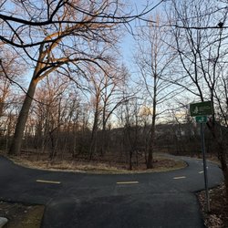
Honestly this may be my favorite spot in Montgomery county and that is not only because i can walk to it in less than 15 minutes. I just love the walk, most of it is paved and the leaves are moved off the sidewalk in the fall. If you want to walk all the way around the lake, bring water, walking sticks, and waterproof shoes because you will have to cross the stream twice. Other than the potential of your feet getting wet, it is a super fun time! Plan for about 1.5 hours to complete the entire loop. This is also a fun overshoot of Rock Creek Park...if you are looking for a short respite...this is it!!! It looks a lot like Lake Needwood but I promise you, it is different and far less populated (mostly because of the hills!!!)


This park is beautiful and serene. They have bike trails, hiking trails, jogging trails and you can also go fishing or simply have a picnic here. Some people are friendly and polite while others are literally scared of other people who don't look like them on the trails. SMH. Some things and some people will never change their racist ways. And it's sad because, they don't even realize that they're being racist.

6 months ago
Located in the Derwood/Rockville area of Moco! My alumni association recently did a hike here but I missed it so I decided to explore this trail on my own. I visited on an early Sunday morning. I parked off Avery Road and there were a few cars already there. The change of scenery was nice. I enjoyed the scenic and peaceful views! read more


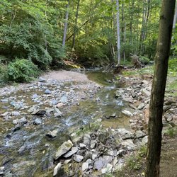
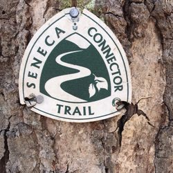
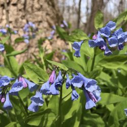
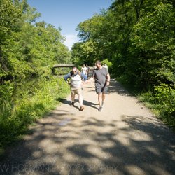
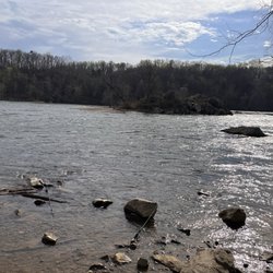
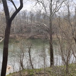
This is a lovely park, with plenty of hiking options and the feel of being in deep woods while actually located in the middle of town (Rockville). The lake itself is gorgeous, and always so picturesque.... I have hiked the Lakeside Trail a few times, which is about three miles and mostly wooded, with two creek crossings (one easy, the other more difficult, requiring stepping on stones that could be slippery or even, at times, underwater). The first time we hiked the trail we did get lost as we skipped the difficult creek crossing and ended up going straight, and almost right back out of park...so bring water to drink and wear (or bring) a pair of shoes that can handle the creek water (it's not safe to swim--so I'm assuming, or wade around--in). UPDATE: Part of the Lakeside Trail has construction going on around it (near the easier stream crossing) and last time we encountered it we decided to turn around rather than trying to get around the mess...but there are other parts of the trail to explore, including hiking along the path that' intersects with Rock Creek Trail (or you can go around the other end of the Lakeside Trail, close to the Avery Park entrance...) Usually when we're here we don't do the entire trail, anyway, but turn around at various points, depending upon how long we want to walk. Although the park does get busy on weekends (and it can be difficult to get a parking spot at the Avery Park lot) the further along the trails you go the less people you'll encounter. Weekdays are also pretty peaceful. I look forward to visiting the Meadowside Nature Center when it reopens--this is located at the other park entrance at Muncaster Mill Road. read more


8 months ago
1 year ago
6 years ago
Honestly this may be my favorite spot in Montgomery county and that is not only because i can walk to it in less than 15 minutes. I just love the walk, most of it is paved and the leaves are moved off the sidewalk in the fall. If you want to walk all the way around the lake, bring water, walking sticks, and waterproof shoes because you will have to cross the stream twice. Other than the potential of your feet getting wet, it is a super fun time! Plan for about 1.5 hours to complete the entire loop. This is also a fun overshoot of Rock Creek Park...if you are looking for a short respite...this is it!!! It looks a lot like Lake Needwood but I promise you, it is different and far less populated (mostly because of the hills!!!) read more


4 years ago
5 years ago
This park is beautiful and serene. They have bike trails, hiking trails, jogging trails and you can also go fishing or simply have a picnic here. Some people are friendly and polite while others are literally scared of other people who don't look like them on the trails. SMH. Some things and some people will never change their racist ways. And it's sad because, they don't even realize that they're being racist. read more


4 years ago
New to walking trails and have only been here twice. Went with a friend and on our first visit, I just did a bit of exploring - did not go further than the dam area (from the Avery Road entrance); Our second visit (same entrance), did a bit more walking on the Lakeside Trail (Hard Surface Trail Connector). By the dam is just one of a few views I saw of the water. I did not walk very far (maybe 3/4 way up the right side of Lake Bernard Frank and back. It is great for walking overall, but I like to have nice views to look at (at times) when I walk and parts of the path I was on didn't really show much. At times I saw overgrown grass and was not sure that path even looked like the trail (hard surface area) and another time we came to an area where I thought we would see a brook and it was very much dried up. Maybe on my next visit, a different path can be tried (to see if they have better views while walking). read more


 - Hiking Near Me - Rockville, Maryland")
 - Hiking Near Me - Rockville, Maryland")
4 years ago
4 years ago
9 years ago
9 years ago
More info about Lake Frank
15211 Avery Rd
Rockville, MD 20855
Directions
Hours
Outdoor Amenities
Ask the Community - Lake Frank
Review Highlights - Lake Frank
You might also consider


Lake Frank - hiking - Updated May 2026
Best of Rockville
People found Lake Frank by searching for…
Fishing Spots in Rockville, Maryland
Swimming Holes in Rockville, Maryland
Swimming Lakes in Rockville, Maryland
Walking Trails in Rockville, Maryland
River Swimming in Rockville, Maryland
Picnic Areas in Rockville, Maryland
Hiking Trails in Rockville, Maryland
Dog Swimming in Rockville, Maryland
Scenic View in Rockville, Maryland
Places to Take Pictures in Rockville, Maryland
Beautiful Views in Rockville, Maryland
Boat Rental in Rockville, Maryland
Free Things to Do in Rockville, Maryland
Dog Friendly Hiking Trails in Rockville, Maryland
Lakes & Ponds in Rockville, Maryland
Running Trails in Rockville, Maryland
Night Hike in Rockville, Maryland
Fishing Lake in Rockville, Maryland
Night Walk in Rockville, Maryland
Spearfishing in Rockville, Maryland
Party Cruise in Rockville, Maryland
Trending Searches in Rockville, MD
Botanical Gardens near Lake Frank
Bounce House Rentals near Lake Frank
Cherry Picking near Lake Frank
Dog Friendly Things To Do near Lake Frank
Dog Friendly Trails near Lake Frank
Nurseries & Gardening near Lake Frank
Outdoor Activities near Lake Frank
Outdoor Basketball Courts near Lake Frank
Outdoor Furniture Stores near Lake Frank
Parks With Pull Up Bars near Lake Frank
Party Equipment Rentals near Lake Frank
Pick Your Own Farms near Lake Frank
Places To Take Pictures near Lake Frank
Pontoon Boat Rentals near Lake Frank
Private Boat Charters near Lake Frank
Running Trails near Lake Frank
Scenic Restaurants near Lake Frank
Strawberry Picking near Lake Frank
Swimming Holes near Lake Frank
Table And Chair Rentals near Lake Frank
Volleyball Courts near Lake Frank
Browse Nearby
BEST of Rockville, Maryland Walking Trails near Lake Frank
BEST of Rockville, Maryland Coffee near Lake Frank
BEST of Rockville, Maryland Restaurants near Lake Frank
BEST of Rockville, Maryland Things to Do near Lake Frank
BEST of Rockville, Maryland Breakfast near Lake Frank
BEST of Rockville, Maryland Parks near Lake Frank
BEST of Rockville, Maryland Taxis near Lake Frank
Browse Brands
Related Searches in Rockville, MD
Affordable Fishing Rental Services in Rockville, Maryland
Affordable Jet Ski Rental Options in Rockville, Maryland
Affordable Kayak Rental Services in Rockville, Maryland
Best Crabbing Locations to Visit in Rockville, Maryland
Best Fishing Locations and Guides in Rockville, Maryland
Best Parks for Parties and Events in Rockville, Maryland
Best Places for Horseback Riding in Rockville, Maryland
Best Waterfalls and Swimming Holes in Rockville, Maryland
Boat Services and Rentals Available in Rockville, Maryland
Book Top Fishing Trips in Rockville, Maryland Today
Check Out Off Road Trails in Rockville, Maryland
Discover Dog Friendly Trails to Explore in Rockville, Maryland
Discover Kid Friendly Hiking Trails in Rockville, Maryland
Discover Lakes & Ponds to Explore in Rockville, Maryland
Discover Scenic Mountain Bike Trails Near Rockville, Maryland
Discover Scenic Waterfall Spots in Rockville, Maryland
Discover Top Boat Tours in Rockville, Maryland for All Ages
Discover Top Nature Parks to Visit in Rockville, Maryland
Discover Top State Parks to Visit in Rockville, Maryland
Discover a Hiking Trail in Rockville, Maryland
Discover the Best Beaches in Rockville, Maryland
Discover the Best Fishing Lake in Rockville, Maryland
Discover the Best Night Hike Trails in Rockville, Maryland
Discover the Best Tide Pools in Rockville, Maryland
Dog-Friendly Hikes With Dogs in Rockville, Maryland
Enjoy Camping Adventures Around Rockville, Maryland
Enjoy Exciting Mountain Biking Adventures in Rockville, Maryland
Enjoy Fishing Pier Spots in Rockville, Maryland With Scenic Views
Enjoy Fishing With Kids in Rockville, Maryland Safely
Enjoy Hiking Adventures in Rockville, Maryland
Enjoy Kayaking Adventures in Rockville, Maryland
Enjoy River Tubing Adventures in Rockville, Maryland
Enjoy Sailing Adventures in Rockville, Maryland
Enjoy Tent Camping Spots Around Rockville, Maryland
Enjoy Water Activities and Fun in Rockville, Maryland
Enjoy a Beautiful Waterfall Hike in Rockville, Maryland
Enjoy a Peaceful Nature Walk in Rockville, Maryland
Enjoy a Scenic Boat Ride in Rockville, Maryland
Enjoy the Best Tubing Experiences in Rockville, Maryland
Enjoy the Best Walking Trails in Rockville, Maryland
Exciting Cliff Jumping Spots in Rockville, Maryland
Experience Deep Sea Fishing Adventures in Rockville, Maryland
Experienced Fishing Guides Available in Rockville, Maryland
Explore Beautiful Parks and Green Spaces in Rockville, Maryland
Explore Boat Rentals for Every Need in Rockville, Maryland
Explore Easy Hikes Perfect for All in Rockville, Maryland
Explore Fun Activities to Do in Rockville, Maryland
Explore Popular Boat Charters Near Rockville, Maryland
Browse Articles
People who viewed Lake Frank also viewed
Rock Creek Regional Park
8 reviews
Lake Needwood Boats
11 reviews
Billy Goat Trail
21 reviews
Rachel Carson Conservation Park
4 reviews
Willard Avenue Neighborhood Park
3 reviews
Damascus Recreational Park
5 reviews
Locust Grove Nature Center
5 reviews
Lake Artemesia Natural Area
69 reviews
Little Paint Branch Park
5 reviews
Wheaton Regional Park
96 reviews