Matthew Henson Trail Photos


You might also consider
More like Matthew Henson Trail
Recommended Reviews - Matthew Henson Trail
Start your review...

3 years ago
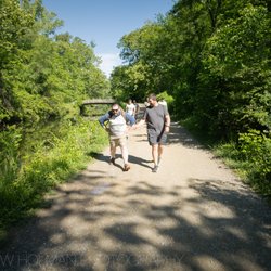
I adore this local trail. Perfect for strolls with the family, small kids in strollers, bikers & walking your dog. It stretches for miles into dc region if your running or biking for marathons. Lots of benches for breaks between miles. A picnic gazebo area and soccer field towards Georgia Ave side (unit 3). read more


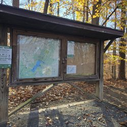
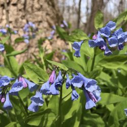
Beautiful trails with plentiful benches. I live right next to the Matthew Trail and casually walk my dog once in a while. The trails goes all the way down to Georgia Ave which is about a 45 min walk from my house, Great Exercise! The trails are very clean and well maintained. Most of the trail are lined with the backyard of houses but the trees help block out the sun and create a perfect walk in the park. My dog loves this trails as there are many other patrons walking their dogs as well. I've seen many bikers and runners on the trails and I seem to meet some regulars now that I go! At the end of one of the pathway includes information on the Matthew Henson Trail and it's origin. Definitely recommend reading the board if you even see it. If you live near Georgia ave and want to take a mod I g walk or a run, I definitely recommend the trail. read more
5 years ago
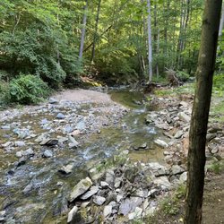
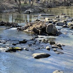
Very nice trail for your daily walk/run/bike ride - nicely taken care of (they even have trash bags set out for your trash) some of trail is boardwalk style - there are benches and parks with picnic tables along the way..I started at Layhill RD entrance today and followed trail to Turkey Branch/Aspen Hill area but you can also take this same trail and connect with Rock Creek en route to DC if your an explorer like me. Within the first 10min today I saw a deer straight chillen laying down in the woods taking in the sun..then a couple more friendly deers a bit later. Most of trail backs up to backyards from nearby residents but there is still woods and streams of water along the way. read more


6 years ago
4 years ago
More info about Matthew Henson Trail
Silver Spring, MD 20906
Directions
Hours
Outdoor Amenities
Ask the Community - Matthew Henson Trail


Matthew Henson Trail - hiking - Updated June 2026
Best of Silver Spring
People found Matthew Henson Trail by searching for…
Parks in Silver Spring, Maryland
Walking Trails in Silver Spring, Maryland
Picnic Areas in Silver Spring, Maryland
Running Trails in Silver Spring, Maryland
Bike Trails in Silver Spring, Maryland
Dog Friendly Hiking Trails in Silver Spring, Maryland
Playgrounds in Silver Spring, Maryland
Flower Fields in Silver Spring, Maryland
Scenic View in Silver Spring, Maryland
Boardwalk in Silver Spring, Maryland
Free Things to Do in Silver Spring, Maryland
Stroller Walk in Silver Spring, Maryland
Night Hike in Silver Spring, Maryland
Picnic Areas BBQ Pits in Silver Spring, Maryland
Walking Groups in Silver Spring, Maryland
Off Leash Dog Hiking Trails in Silver Spring, Maryland
Picnic Spots in Silver Spring, Maryland
Easy Hikes in Silver Spring, Maryland
Mountain Biking in Silver Spring, Maryland
Waterfall Hike in Silver Spring, Maryland
Places to Walk in Silver Spring, Maryland
Toddler Playground in Silver Spring, Maryland
Trending Searches in Silver Spring, MD
Black Owned Nail Salons near Matthew Henson Trail
Boat Rental near Matthew Henson Trail
Cliff Jumping near Matthew Henson Trail
Creeks near Matthew Henson Trail
Day Trips near Matthew Henson Trail
Dog Friendly Trails near Matthew Henson Trail
Fireworks near Matthew Henson Trail
Fishing Spots near Matthew Henson Trail
Jet Ski Rental near Matthew Henson Trail
Kayak Rental near Matthew Henson Trail
Lakes & Ponds near Matthew Henson Trail
Outdoor Activities near Matthew Henson Trail
Places To Walk Around near Matthew Henson Trail
Public Pools near Matthew Henson Trail
Public Shower near Matthew Henson Trail
River Swimming near Matthew Henson Trail
Rock Quarry near Matthew Henson Trail
Scenic Night View near Matthew Henson Trail
Scenic Overlook near Matthew Henson Trail
Secluded Spots near Matthew Henson Trail
Soccer Store near Matthew Henson Trail
Splash Pad near Matthew Henson Trail
Strawberry Picking near Matthew Henson Trail
Sunrise View near Matthew Henson Trail
Swimming Holes near Matthew Henson Trail
Swimming Lakes near Matthew Henson Trail
Watch Sunset near Matthew Henson Trail
Browse Articles
Browse Nearby
BEST of Silver Spring, Maryland Walking Trails near Matthew Henson Trail
BEST of Silver Spring, Maryland Coffee near Matthew Henson Trail
BEST of Silver Spring, Maryland Restaurants near Matthew Henson Trail
BEST of Silver Spring, Maryland Things to Do near Matthew Henson Trail
BEST of Silver Spring, Maryland Breakfast near Matthew Henson Trail
BEST of Silver Spring, Maryland Parks near Matthew Henson Trail
BEST of Silver Spring, Maryland Snow Tubing near Matthew Henson Trail
BEST of Silver Spring, Maryland Ski Resorts near Matthew Henson Trail
BEST of Silver Spring, Maryland Motel near Matthew Henson Trail
Browse Brands
Related Searches in Silver Spring, MD
Affordable Kayak Rental Services in Silver Spring, Maryland
Best Fishing Locations and Guides in Silver Spring, Maryland
Best Places for Horseback Riding in Silver Spring, Maryland
Best Waterfalls and Swimming Holes in Silver Spring, Maryland
Check Out Off Road Trails in Silver Spring, Maryland
Discover Dog Friendly Trails to Explore in Silver Spring, Maryland
Discover Scenic Bike Paths in Silver Spring, Maryland
Discover Scenic Mountain Bike Trails Near Silver Spring, Maryland
Discover Top State Parks to Visit in Silver Spring, Maryland
Discover a Hiking Trail in Silver Spring, Maryland
Discover the Best Night Hike Trails in Silver Spring, Maryland
Dog-Friendly Hikes With Dogs in Silver Spring, Maryland
Enjoy Camping Adventures Around Silver Spring, Maryland
Enjoy Exciting Mountain Biking Adventures in Silver Spring, Maryland
Enjoy Kayaking Adventures in Silver Spring, Maryland
Enjoy Tent Camping Spots Around Silver Spring, Maryland
Enjoy a Beautiful Waterfall Hike in Silver Spring, Maryland
Enjoy a Peaceful Nature Walk in Silver Spring, Maryland
Enjoy the Best Walking Path in Silver Spring, Maryland
Enjoy the Best Walking Trails in Silver Spring, Maryland
Exciting Cliff Jumping Spots in Silver Spring, Maryland
Explore Beautiful Parks and Green Spaces in Silver Spring, Maryland
Explore Easy Hikes Perfect for All in Silver Spring, Maryland
Explore Fun Activities to Do in Silver Spring, Maryland
Explore Popular Campgrounds Near Silver Spring, Maryland
Explore the Best Beach Spots in Silver Spring, Maryland
Explore the Best Boating Spots in Silver Spring, Maryland
Explore the Best Swimming Holes Around Silver Spring, Maryland
Explore the Best Trail Options in Silver Spring, Maryland
Family Friendly Hiking With Kids in Silver Spring, Maryland
Find Beautiful Views in Silver Spring, Maryland
Find Popular Ziplining Spots Around Silver Spring, Maryland
Find the Best Parks for Picnics in Silver Spring, Maryland
Find the Best Scenic View Locations in Silver Spring, Maryland
Great Places to Walk in Silver Spring, Maryland
Hiking Trails With Waterfalls in Silver Spring, Maryland
Off Leash Dog Hiking Trails in Silver Spring, Maryland
Plan a Scenic Drive Route Near Silver Spring, Maryland
Popular Fishing Spots to Explore in Silver Spring, Maryland
Popular Outdoor Activities to Try in Silver Spring, Maryland
Popular Picnic Spots to Visit in Silver Spring, Maryland
Safe River Swimming Areas in Silver Spring, Maryland
Safe and Fun Parks for Kids in Silver Spring, Maryland
Top Climbing Spots and Gyms in Silver Spring, Maryland
Top Paddleboarding Activities in Silver Spring, Maryland
Top Running Trails to Explore in Silver Spring, Maryland
Top Swimming Lakes to Enjoy in Silver Spring, Maryland
Top Swimming Spots and Pools in Silver Spring, Maryland
Walk Dog Friendly Hiking Trails in Silver Spring, Maryland
Walk the Best Paved Walking Trails in Silver Spring, Maryland
People who viewed Matthew Henson Trail also viewed
Sligo Creek Park
21 reviews
Rock Creek Trail
14 reviews
Carderock Recreational Area
16 reviews
Greenbelt Park
41 reviews
Matthew Henson State Park
3 reviews
Fairland Recreational Park
14 reviews
General Getty Neighborhood Park
5 reviews
Lake Needwood
21 reviews
Rockville Millenium Trail
1 review
Sligo Creek Trail
2 reviews