Mount Bonnell Photos


You might also consider
More like Mount Bonnell
Recommended Reviews - Mount Bonnell
Start your review...

Reviews With Photos

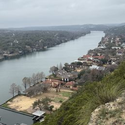
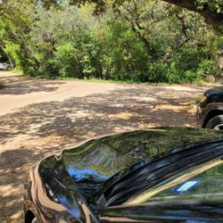
When time is of essence and you want to get in a short hike with views, make sure to hit this spot. The drive up was quite nice, lots of beautiful homes...multimillion dollar homes! You'll see an area with plenty of parking available, doused here and there with fruit/agua fresca stands. Anywhere you park, you'll hike up a steep short path and once you've reached the top, gorgeous river and Texas country views abound. Lots of photo opportunities everywhere. Also, a small historical area with information regarding Mount Bonnell was picture worthy. Check it out!
")
I've been to Mount Bonnell a couple of times but it's been a long while since I've been recently. It really hasn't changed much over the last 4 years; it tends to be pretty packed most evenings and especially on the weekends! There is parking along the road but be VERY mindful of locking your car and keeping valuables out of site because this is a common place where people's cars get broken into unfortunately. The walk up to the lookout is relatively short, I wouldn't call this a hike, it's more a big outdoor staircase to a pretty overlook where you can see the river and downtown Austin in the distance. It is lovely at sunset though! And you can walk a little bit further down from the lookout but as far as I know there isn't a main trail or a longer hike (but maybe there is one and I just don't know). Overall if you're visiting Austin or here for a short period of time, you definitely should make at least one trip out to Mt. bonnell! It isn't a place you really need to come visit several times tho unless you just like the view at the overlook.

Highest point in Austin area. At the overlook you can see downtown Austin skyline, Colorado River and it's surrounding. You don't have to use the stairs to go up to the top, go to the other end of the parking lot and u can hike up to the top. It is a must see if u are in the area. Watch out for car break in tho.

Anyone under the misunderstanding that Texas is flat,just needs to climb the Stairs of Mount Bonnell. While only 800 ft to the top,the stairs at almost a 45 degree angle can be moderately challenging if your over 40! If you're in the Austin area and want a break from the traffic, congestion and overbuilding,take a short trip to Mt Bonnell for a breather. Guaranteed to lower your blood pressure. Certainly a 5 Star View... Go!


Loved visiting Mount Bonnell on an overcast day! My GPS took me right to the bottom of the steps, where it was easy to park. I was a little nervous about parking, but it was easy! The flight of steps is steep, but not too bad. Once at the top you can look out and see the river and beautiful houses. This attraction is free and there were people having picnics up at the top. I would go back here. I was SO nervous that people let their kids just run wild up on top of the cliff. It is definitely not safe since you can just walk or stumble right off of the edge. I'd love to go back when the sun comes up. Pretty spot to take in the scenery!

Such a special spot in Austin! The views never cease to be breathtaking. Highly recommend coming at sunset. There are some spots to sit for a cute picnic. Be warned that at peak times there might be a lot of people and you may need to wait to take a photo. The initial climb up is definitely a bit tiring, approximately 50 stairs.


First time coming here!! There may be a short hiking path but we drove up to the parking spot where we just climbed up the stairs of 100 steps etc. from the top, the view was very nice and beautiful! You'll get to see either the scenery of the downtown Austin or the river! It's a nice location to look out the view and enjoy nature!! Come see it and have fun! Cheers

This spot should be on your Austin bucket list! It's an easy hike to get up to the overlook. Dogs are allowed here (on leash) too. The views of downtown and Lake Austin are stunning! Parking is relatively easy but there have reports of break-ins so lock up your valuables. Wear sunscreen and be ready to take some great photos.

So as you begin your trek up Mount Bonnell... you end it. Yup, the name is egregiously misleading. We will say the view is stunning and provides a great lookout point up and down the Colorado River. We understand it got its name because it's the highest point in Austin but if you come here expecting a hike then you're better off somewhere else. The parking can be tricky as it's immediately off the road and the steps up are a good workout for 40 seconds. For what it is though, it's a pretty lookout, just not really anything remarkable.

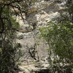
Mount Bonnell was a place that we were told we really needed to go when we were visiting Austin. You get on top of the ridge (at least this is a ridge to me as I was born and raised and lived in mountain states where the mountains are quite large) and you can get a great view of downtown Austin with it's cityscape and then you can also get a good view of the Colorado River and the neighborhoods across the river which are quite nice. The terrain is rocky on top so watch your step and there are a fair amount of people up here enjoying the view as well. I am sure sunrises and sunsets are beautiful and very impressive. We walked for a ways and got a few different vantage points of the views so if you are able to do that I definitely recommend doing so. It's a great place and indeed a place to go when visiting. The locals enjoy it too! read more


1 month ago
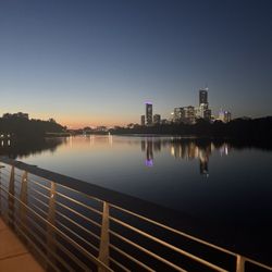
Mount Bonnell is one Austin's top tourist attractions. You climb about a hundred stone steps to reach the top. You see folks coming down steps on the opposite side and your sense of what you might see at the top grows and grows. Alas, you reach the top. Was the climb worth it? Absolutely! When you reach the top, OMG the views are so spectacular! You cannot imagine how beautiful the views are until you actually see them. You see panoramic views of Lake Austin, multi-million residences on the lake and scenic view of Austin. One word...spectacular! We have been at Mt. Bonnell at sunrise and sunset and both views have something special to offer. Sunrise has peacefulness and light dances on Lake Austin. Sunset turns the overlook into connectiveness, where folks you met a few minutes ago or maybe not have met experience this quiet together as the sun retreats. While this location is quite popular, you still have vestiges of human life - graffiti on signage. Mount Bonnell has welcomed visitors since the 1800s and remains one of the city's oldest and most beloved natural landmarks. Austinites beam with pride regarding Mt. Bonnell read more


Mount Bonnell is a local gem, a perfect date spot or somewhere to just enjoy the sunset. It's a short walk up the stairs (maybe about 100 steps) from the parking to the pagoda-like terrace that overlooks some very scenic homes and has an excellent view of sunrise and sunset. I never actually did the full hike, only just went up to enjoy the scenery. It's less than 15 minutes from major Austin eateries and local spots, so it's a true gem within the city area as opposed to some hikes that are 30 minutes or an hour away. No bathrooms or garbage bins here is the one downside. Take your trash with you! read more

4 months ago
When time is of essence and you want to get in a short hike with views, make sure to hit this spot. The drive up was quite nice, lots of beautiful homes...multimillion dollar homes! You'll see an area with plenty of parking available, doused here and there with fruit/agua fresca stands. Anywhere you park, you'll hike up a steep short path and once you've reached the top, gorgeous river and Texas country views abound. Lots of photo opportunities everywhere. Also, a small historical area with information regarding Mount Bonnell was picture worthy. Check it out! read more


6 months ago
I've been to Mount Bonnell a couple of times but it's been a long while since I've been recently. It really hasn't changed much over the last 4 years; it tends to be pretty packed most evenings and especially on the weekends! There is parking along the road but be VERY mindful of locking your car and keeping valuables out of site because this is a common place where people's cars get broken into unfortunately. The walk up to the lookout is relatively short, I wouldn't call this a hike, it's more a big outdoor staircase to a pretty overlook where you can see the river and downtown Austin in the distance. It is lovely at sunset though! And you can walk a little bit further down from the lookout but as far as I know there isn't a main trail or a longer hike (but maybe there is one and I just don't know). Overall if you're visiting Austin or here for a short period of time, you definitely should make at least one trip out to Mt. bonnell! It isn't a place you really need to come visit several times tho unless you just like the view at the overlook. read more
 - Hiking Near Me - Austin, Texas")
8 months ago
Highest point in Austin area. At the overlook you can see downtown Austin skyline, Colorado River and it's surrounding. You don't have to use the stairs to go up to the top, go to the other end of the parking lot and u can hike up to the top. It is a must see if u are in the area. Watch out for car break in tho. read more


Anyone under the misunderstanding that Texas is flat,just needs to climb the Stairs of Mount Bonnell. While only 800 ft to the top,the stairs at almost a 45 degree angle can be moderately challenging if your over 40! If you're in the Austin area and want a break from the traffic, congestion and overbuilding,take a short trip to Mt Bonnell for a breather. Guaranteed to lower your blood pressure. Certainly a 5 Star View... Go! read more


Lots of steps to get to the point, but wow was it worth it! The view was gorgeous and perfect for photos. Just be careful of the steps and hold onto the rail, my young daughter tripped a few times since it's a bit uneven. read more


Loved visiting Mount Bonnell on an overcast day! My GPS took me right to the bottom of the steps, where it was easy to park. I was a little nervous about parking, but it was easy! The flight of steps is steep, but not too bad. Once at the top you can look out and see the river and beautiful houses. This attraction is free and there were people having picnics up at the top. I would go back here. I was SO nervous that people let their kids just run wild up on top of the cliff. It is definitely not safe since you can just walk or stumble right off of the edge. I'd love to go back when the sun comes up. Pretty spot to take in the scenery! read more


Such a special spot in Austin! The views never cease to be breathtaking. Highly recommend coming at sunset. There are some spots to sit for a cute picnic. Be warned that at peak times there might be a lot of people and you may need to wait to take a photo. The initial climb up is definitely a bit tiring, approximately 50 stairs. read more


First time coming here!! There may be a short hiking path but we drove up to the parking spot where we just climbed up the stairs of 100 steps etc. from the top, the view was very nice and beautiful! You'll get to see either the scenery of the downtown Austin or the river! It's a nice location to look out the view and enjoy nature!! Come see it and have fun! Cheers read more


This spot should be on your Austin bucket list! It's an easy hike to get up to the overlook. Dogs are allowed here (on leash) too. The views of downtown and Lake Austin are stunning! Parking is relatively easy but there have reports of break-ins so lock up your valuables. Wear sunscreen and be ready to take some great photos. read more


So as you begin your trek up Mount Bonnell... you end it. Yup, the name is egregiously misleading. We will say the view is stunning and provides a great lookout point up and down the Colorado River. We understand it got its name because it's the highest point in Austin but if you come here expecting a hike then you're better off somewhere else. The parking can be tricky as it's immediately off the road and the steps up are a good workout for 40 seconds. For what it is though, it's a pretty lookout, just not really anything remarkable. read more


9 months ago
I brought my brother by on his visit from Kansas City. We hit this spot right after picking him up at the airport. It was a very hot day in May, so we appreciated the trails off the stairway with picnic tables to take a quick break and see the beautiful views of the Austin skyline. The views all the way around are wonderful. Especially the lake and beautiful homes along the lake. read more


2 years ago
Thank you to the friendly local when we first arrived for recommending us to stop by the views here. We came by at sunset and the walk is very brief. It's about a 5-10 minute stroll and you have varying angles of the skyline, multimillion dollar homes nearby and the Colorado River. It made me feel very serene and grateful to be around great friends to enjoy the views. This is certainly a must stop if you're in Austin. If I lived here, I would probably be here very frequently with a charcuterie board and some snaccs. read more

6 months ago
Mount Bonnell is a must-visit tourist attraction in Austin! There was plenty of free parking on a Sunday afternoon and people came and went quickly just for photo ops, so you can enjoy the views without too much crowd in between. You can take a short hike to the summit or the steps (we took the just over 100 steps) and it's well worth it for the breathtaking panoramic views of the city and the Colorado River. It's the perfect spot for a scenic photo, a romantic sunset, or simply soaking in the natural beauty. We decided not to wait for sunset as it didn't work as with our itinerary, but since it's the highest point in Austin, you'll see other reviews with nice sunset photos! We also skipped the hiking as it was very hot that day, but nonetheless, worth a visit! read more


Neat little hike with great views of the river or whatever situated below. Not breathtaking views, mind you, just mildly exciting. The passerby here are just part of the scenery. Pay them no mind. It is as if they are invisible and don't exist. Last visited: Dec' 23. In the Austin (A-TX) area. The day after X-mas. Hike is not even tiresome, and very short. You just hike up some rocks. Pass some useless folk along the way, and snap some pointless photos. At the top (I'm the only one that cared to make it), you're treated to some dilapidated rubbish and lot of folks hanging around admiring said rubbish, and ignoring others completely. Not worth snapping photos of this sad sight, hence why I turned back posthaste. All in all, this hike is borderline worthless, but the views are passable. I'll give it a strong D- and call it a day. Huzzah. read more


2 years ago
Nice walk to see the lake. Small parking space but it wasn't crowded on the weekend we went. I love the short walk to get a beautiful view and get the serenity of being in nature. No crazy crowd was a plus. read more


Great lookout point for not a lot of work/hike beforehand. Most difficult part is climbing the short few flights of stairs, which aren't even that bad. The edges are only roped off so keep a close hold of small, curious children also trying to enjoy the scenery. Great spot to bring out of town guests and families to show them a glimpse of hill country and gawk at the gorgeous multimillion dollar homes on the drive back down. Plenty of free parking. read more

Wow what a view!! I do not blame the people who live right off the water. It is a perfect mix of hill tops, mountains, houses and water. The walk to the top is not very difficult and definitely a place where families will spend their afternoon together. If you have younger kids, please keep your eyes on them! There is no kind of barrier/fence which is quite dangerous. There is plenty of parking. Keep in mind it is a nice place to enjoy the view but do not expect to take a hike that will last you hours. There are protruding rocks everywhere so watch out not to fall or you may need a Band-Aid. read more


A must-visit when you're in Austin. The view of the Colorado river, Austin skyline, and homes along the Water Edge St are breathtaking and blissful. Go up the flight of stairs to get to the spot. While parking may look like a challenge, you won't have trouble finding any as people are pulling in and out. It's also the highest point in Texas at around 781 feet which is saying something. Be careful as you look down and climb down on the rocks and ledges; one slip and you're in for a nasty tumble. But the scenes are breathtaking and worth it. Another reason why Austin is a killer city and one of my favorites! read more


 - Hiking Near Me - Austin, Texas")


2 years ago
Beautiful views of Austin and Lake Austin. A must do when in town. There's several steps to get to the top from the parking lot (less than 5 min). But from the top, you can take side rocky roads for clearer views of the lake. read more


 - Hiking Near Me - Austin, Texas")
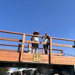
This is definitely one of those Austin destinations that should be on every body's list. There's usually plenty of parking and you can have your choice of going up the mountain gradually, or take the exhausting stairway. However, once at the top, you are treated to some of the best views of Austin and the surrounding hill country. On one side of the mountain you have a glorious view of the Austin skyline and on the other end the Pennybacker Bridge. There are a couple of picnic tables at the top, but to be honest, it's not the best place to have a picnic because of all the sightseers. read more


Quite a few stairs to go up but there is a ramp to the far right at the end of the parking that you can walk up instead. For such a flat city this is a nice view. It's a quick little hike that gets you away from the city. I enjoy seeing the mansions across the way and we even had a little snack at one of the tables off to the side. There is plenty of parking available. read more


1 year ago
Fun little stop! Beautiful views. Easy hike, good for all ages. We went over Christmas break, temps were perfect. read more


3 years ago
A quick 10min (0.5mi) "hike" on paved rock path, slight incline, with a great view of lakefront properties of those more wealthy than myself. Apparently the highest point in Texas, which says a lot. read more


2 years ago
Page 1 of 13
More info about Mount Bonnell
3800 Mt Bonnell Rd
Austin, TX 78731
Directions
(512) 974-6700
Call Now
Visit Website
https://www.mountbonnell.com
Hours
Indoor Amenities
Outdoor Amenities
Ask the Community - Mount Bonnell
How long does it take to get to the top?
In a few minutes really. It should be easy for most.
I have a very active 4 n 5 yr old and was wondering if it would be too dangerous for them? is their fencing of any sort of just straight cliff down? Or should i have a stroller?
A stroller won't work, long flight of steps If they climb up they will be tired. No safety fence.
Is this place stroller friendly?
Maybe a foldable small one but I wouldn't recommend as there're steep stairs. I carried my 2yr old daughter up to the top and was glad I didn't bring the stroller :)
Review Highlights - Mount Bonnell
You might also consider


Why does Yelp recommend reviews?
27 reviews that are not currently recommended
The reviews below are not factored into the business's overall star rating.
2 years ago
1 year ago
4 years ago
11 years ago
9 years ago
18 days ago
10 years ago
15 years ago
11 years ago
18 years ago
10 years ago
12 years ago
10 years ago
8 years ago
12 years ago
13 years ago
9 years ago
13 years ago
11 years ago
Mount Bonnell - hiking - Updated June 2026
Best of Austin
People found Mount Bonnell by searching for…
Trending Searches in Austin, TX
Amusement Parks near Mount Bonnell
Baseball Fields near Mount Bonnell
Bird Sanctuary near Mount Bonnell
Black Owned Nail Salons near Mount Bonnell
Boat Rental near Mount Bonnell
Cliff Jumping near Mount Bonnell
Dog Friendly Beaches near Mount Bonnell
Dog Friendly Things To Do near Mount Bonnell
Fishing Spots near Mount Bonnell
Free Kids Activities near Mount Bonnell
Free Water Parks near Mount Bonnell
Jet Ski Rental near Mount Bonnell
Kids Activities Outdoor near Mount Bonnell
Outdoor Activities near Mount Bonnell
Outdoor Basketball Courts near Mount Bonnell
Parks With Pull Up Bars near Mount Bonnell
Playgrounds near Mount Bonnell
Public Beaches near Mount Bonnell
Public Pools near Mount Bonnell
Public Shower near Mount Bonnell
Rock Quarry near Mount Bonnell
Running Trails near Mount Bonnell
Scenic Drive near Mount Bonnell
Secluded Spots near Mount Bonnell
Soccer Store near Mount Bonnell
Strawberry Picking near Mount Bonnell
Sunrise View near Mount Bonnell
Swimming Holes near Mount Bonnell
Swimming Lakes near Mount Bonnell
Swimming Pools near Mount Bonnell
Watch Sunset near Mount Bonnell
Browse Nearby
BEST of Austin, Texas Coffee near Mount Bonnell
BEST of Austin, Texas Restaurants near Mount Bonnell
BEST of Austin, Texas Things to Do near Mount Bonnell
BEST of Austin, Texas Walking Trails near Mount Bonnell
BEST of Austin, Texas Breakfast near Mount Bonnell
BEST of Austin, Texas Parks near Mount Bonnell
BEST of Austin, Texas Caves near Mount Bonnell
Browse Brands
Related Searches in Austin, TX
Affordable Kayak Rental Services in Austin, Texas
Best Fishing Locations and Guides in Austin, Texas
Best Nature Trails for Hiking in Austin, Texas
Best Off Leash Dog Parks in Austin, Texas
Best Parks for Parties and Events in Austin, Texas
Best Places for Horseback Riding in Austin, Texas
Best Water Parks for Kids in Austin, Texas
Best Waterfalls and Swimming Holes in Austin, Texas
Check Out Great Playgrounds in Austin, Texas
Check Out Off Road Trails in Austin, Texas
Discover Baseball Fields Around Austin, Texas
Discover Fun Toddler Parks in Austin, Texas for Your Little One
Discover Kid Friendly Hiking Trails in Austin, Texas
Discover Lakes & Ponds to Explore in Austin, Texas
Discover Popular Photo Spots in Austin, Texas
Discover Public Beaches to Visit in Austin, Texas
Discover Scenic Hiking Trails in Austin, Texas
Discover Scenic Mountain Bike Trails Near Austin, Texas
Discover Scenic Waterfall Spots in Austin, Texas
Discover Soccer Fields in Austin, Texas Near You
Discover Top Nature Parks to Visit in Austin, Texas
Discover Top Scenic Spots to Visit in Austin, Texas
Discover Top State Parks to Visit in Austin, Texas
Discover a Hiking Trail in Austin, Texas
Discover the Best Beaches in Austin, Texas
Discover the Best Kids Park Spots in Austin, Texas
Discover the Best Night Hike Trails in Austin, Texas
Dog-Friendly Hikes With Dogs in Austin, Texas
Enjoy Camping Adventures Around Austin, Texas
Enjoy Exciting Mountain Biking Adventures in Austin, Texas
Enjoy Kayaking Adventures in Austin, Texas
Enjoy Tent Camping Spots Around Austin, Texas
Enjoy a Beautiful Waterfall Hike in Austin, Texas
Enjoy the Best Picnic Spots and Ideas in Austin, Texas
Enjoy the Best Walking Path in Austin, Texas
Enjoy the Best Walking Trails in Austin, Texas
Exciting Cliff Jumping Spots in Austin, Texas
Explore Beautiful Parks and Green Spaces in Austin, Texas
Explore Easy Hikes Perfect for All in Austin, Texas
Explore Family-Friendly Zoos and Wildlife in Austin, Texas
Explore Free Picnic Areas Around Austin, Texas
Explore Fun Activities to Do in Austin, Texas
Explore Parks With Pull Up Bars in Austin, Texas
Explore Popular Campgrounds Near Austin, Texas
Explore Popular Picnic Areas Around Austin, Texas
Explore Popular RV Parks Around Austin, Texas
Explore Popular Recreation Centers Around Austin, Texas
Explore Popular Scenic Views Near Austin, Texas
Browse Articles
People who viewed Mount Bonnell also viewed
Covert Park At Mount Bonnell
50 reviews
The Boardwalk Trail at Lady Bird Lake
110 reviews
Sculpture Falls
37 reviews
Town Lake Metropolitan Parks
177 reviews
Hill Of Life Trail
24 reviews
Lou Neff Point
14 reviews
Town Lake, Barton Hills, 78704 (South Austin)
Barton Creek Greenbelt
38 reviews
78704 (South Austin)
River Place Nature Trail
252 reviews
Lady Bird Lake
124 reviews
East Austin
Ann & Roy Butler Hike & Bike Trail
27 reviews