
Monument Peak Photos

You might also consider
More like Monument Peak
Recommended Reviews - Monument Peak
Start your review...

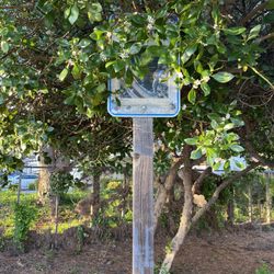
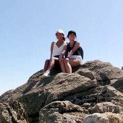
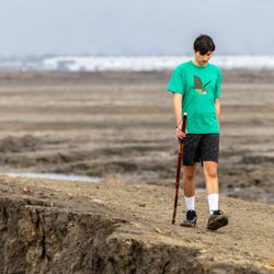
Monument Peak is part of a 3 peaks ridge in the Diablo Range: Mission Peak, Mount Allison, and Monument Peak. They have similar elevation but Monument Peak is a much longer hike, 9 miles loop from Ed Levin park trail head. We started from Ed Levin's Sandy Wool Lake at 8:15 and reached the summit in 2 hours, a fast pace for 4.5 miles and 2210 elevation gain. The scenery in mid June was all dry tall grasses, very exposed on the West hill. I carried an umbrella for my portable shade. It was hot in the high 70s, I wore shorts, and my legs got scratched by some overgrown prickly vegetation. At the summit, we saw on the Westside - the city and the bay; while on the Eastside - Calaveras Reservoir in Calaveras Valley. I like this hike because it is not popular, therefore with no crowds and no noise, we get to enjoy the beauty of the backcountry without going too far from the city. read more
More info about Monument Peak
901 Downing Rd
Milpitas, CA 95035
Directions
Hours
Outdoor Amenities
You might also consider


Monument Peak - hiking - Updated July 2026
Best of Milpitas
People found Monument Peak by searching for…
Fun Things to Do in Milpitas, CA
Walking Trails in Milpitas, CA
Walking Groups in Milpitas, CA
Running Trails in Milpitas, CA
Parks With Shade in Milpitas, CA
Places to Visit in Milpitas, CA
Off Leash Dog Hikes in Milpitas, CA
Free Things to Do in Milpitas, CA
Waterfalls and Swimming Holes in Milpitas, CA
Public Golf Courses in Milpitas, CA
Trending Searches in Milpitas, CA
Blueberry Picking near Monument Peak
Cliff Jumping near Monument Peak
Dog Friendly Things To Do near Monument Peak
Jet Ski Rental near Monument Peak
Kayak Rental near Monument Peak
Off Road Trails near Monument Peak
Outdoor Activities near Monument Peak
Peach Picking near Monument Peak
Picnic Spots near Monument Peak
Public Pools near Monument Peak
Public Shower near Monument Peak
River Swimming near Monument Peak
Rock Quarry near Monument Peak
Scenic Night View near Monument Peak
Scenic Overlook near Monument Peak
Swimming Holes near Monument Peak
Swimming Lakes near Monument Peak
Things To Do On A Rainy Day near Monument Peak
Watch Sunset near Monument Peak
Browse Articles
Browse Nearby
BEST of Milpitas, California Coffee near Monument Peak
BEST of Milpitas, California Things to Do near Monument Peak
BEST of Milpitas, California Restaurants near Monument Peak
BEST of Milpitas, California Walking Trails near Monument Peak
BEST of Milpitas, California Parks near Monument Peak
BEST of Milpitas, California Breakfast near Monument Peak
Browse Brands
Related Searches in Milpitas, CA
Best Dog Hiking Trails Around Milpitas, California
Best Fishing Locations and Guides in Milpitas, California
Best Nature Trails for Hiking in Milpitas, California
Best Places for Horseback Riding in Milpitas, California
Check Out Off Road Trails in Milpitas, California
Discover Dog Friendly Trails to Explore in Milpitas, California
Discover Easy Hiking Trails Near Milpitas, California
Discover Kid Friendly Hiking Trails in Milpitas, California
Discover Popular Bike Trails in Milpitas, California
Discover Scenic Mountain Bike Trails Near Milpitas, California
Discover Walking Parks in Milpitas, California Near You
Discover a Hiking Trail in Milpitas, California
Discover the Best Night Hike Trails in Milpitas, California
Dog-Friendly Hikes With Dogs in Milpitas, California
Enjoy Camping Adventures Around Milpitas, California
Enjoy Kayaking Adventures in Milpitas, California
Enjoy Off Leash Dog Hikes in Milpitas, California
Enjoy Scenic Places to Walk in Milpitas, California
Enjoy Tent Camping Spots Around Milpitas, California
Enjoy a Beautiful Waterfall Hike in Milpitas, California
Enjoy the Best Walking Path in Milpitas, California
Enjoy the Best Walking Trails in Milpitas, California
Explore Beautiful Parks and Green Spaces in Milpitas, California
Explore Easy Hikes Perfect for All in Milpitas, California
Explore Fun Activities to Do in Milpitas, California
Explore Popular Campgrounds Near Milpitas, California
Explore Popular Dog Walking Trails in Milpitas, California
Explore Top Dog Parks in Milpitas, California Near You
Explore the Best Beach Spots in Milpitas, California
Family Friendly Hiking With Kids in Milpitas, California
Find Parks and Recreation Activities in Milpitas, California
Find Top Dog Friendly Parks to Visit in Milpitas, California
Find Top-Rated Waterfalls in Milpitas, California Now
Find the Best Parks for Picnics in Milpitas, California
Hiking Trails With Waterfalls in Milpitas, California
Off Leash Dog Hiking Trails in Milpitas, California
Popular Outdoor Activities to Try in Milpitas, California
Popular Picnic Spots to Visit in Milpitas, California
Popular Waterfall Hiking Trails in Milpitas, California
Safe River Swimming Areas in Milpitas, California
Safe and Fun Parks for Kids in Milpitas, California
Top Hiking Trails to Explore in Milpitas, California
Top Playgrounds for Kids to Enjoy in Milpitas, California
Top Running Trails to Explore in Milpitas, California
Top Swimming Lakes to Enjoy in Milpitas, California
Top Swimming Spots and Pools in Milpitas, California
Top-Rated Camping Sites in Milpitas, California


