Cancel

    Open app

    Search

    Mike Lake

    4.0 (1 review)

    Mike Lake Photos

    Recommended Reviews - Mike Lake

    Your trust is our priority, so businesses can't pay to alter or remove their reviews. Learn more about reviews.
    Yelp app icon
    Browse more easily on the app
    Review Feed Illustration
    Photo of Nina S.
    572
    556
    1868

    2 years ago

    Helpful 0
    Thanks 0
    Love this 0
    Oh no 0

    Verify this business for free

    People searched for Hiking 165 times last month within 15 miles of this business.

    Verify this business

    Golden Ears Provincial Park - August 2026.

    Golden Ears Provincial Park

    4.2(34 reviews)
    26.7 km

    Maple ridge beautiful lake park. A beauty that must be experienced in all seasons. Blue Color lake…read moreis mesmerizing and the wooded forest for hike is brainstorming. Plenty of people come here and book designated picnic tables to celebrate special occasions as many of them have bbq option. Else just the lake side view for any celebration is enough. I have taken many hikes around this beautiful lake and seen breathtaking views so you must go as well. The whole park is huge and I must say I could not explore in just one visit. So you got to come back to it again and again. Enjoy hikes with beautiful lake view but be careful around here as it is pretty wild and some of the trails are not for first timers.

    Golden Ears Provincial Park is a very popular park and campground. Even though it's in Maple…read moreRidge, which is relatively close to Vancouver, I had never been due to lack of transit, but I finally had the opportunity to go on Thursday August 13, 2026 with four friends. Because Golden Ears is such a popular destination, free day passes are required for cars between mid-May to Labour Day on Fridays, Saturdays, Sundays, and Mondays. As we went on a Thursday we didn't require a pass, but we arrived at 11am, which is considered "late" (none of us are morning people), but we lucked out and managed to find one of the few remaining parking spots, and it was very close to the trail head. This was the first time at Golden Ears for all of us, so we took our time exploring and spent over four hours hiking and enjoying the day. We hiked along the East Canyon Trail to Viewpoint Beach, where we stopped for lunch for about half an hour and watched people on horseback frolicking in the water, and then started back down the trail and took the Crossover Trail to the Lower Falls, and then hiked along the Lower Falls Trail back to the parking lot. With the exception of the Crossover Trail, the trails we hiked were very easy, particularly the Lower Falls Trail (I wouldn't even say that this trail was a hike -- it was a walk). The Crossover Trail connects the East Canyon Trail to the Lower Falls, and while short, it was absolutely awful and I would not recommend hiking this "trail". On the map it's noted as a trail, but in my opinion, it really isn't. The Crossover Trail is very steep and the terrain is quite treacherous, particularly if you're short. Several times I just slid on my butt. The trails we hiked were by the North Beach area of Alouette Lake. There are campgrounds and several other trails, ranging from easy to advanced. Unfortunately there is no transit to this part of Golden Ears, but as of this summer, limited transit service to the South Beach of Alouette Lake began. In June, Translink began seasonal service from Haney Place in Maple Ridge to the South Beach parking lot. The #736 ran only on weekends and holidays until Labour Day every half an hour between 7am and 9pm (which is pretty damn good!). I was hoping to try this route out even though a one way transit trip would be 1.5 hours (getting to Haney Place is about an hour and includes 30 minute bus ride), but between my schedule and the limited days the bus ran, I wasn't able to make it before service ended. Also, I wasn't familiar with the hiking trails in the South Beach area, but now that I have been to Golden Ears and have studied the maps, I feel more comfortable exploring Golden Ears and hope to take transit there next summer. Even if I have friends who can drive, I want to support Translink and hope they keep this route going, and maybe expand it -- more transit to hiking trails is needed. [Yelp collections: Hiking; Parks and Gardens]

    Photos
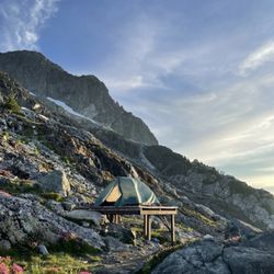
    Golden Ears Provincial Park - One of the 6 tent pads at panorama ridge campground at golden hour

    One of the 6 tent pads at panorama ridge campground at golden hour

    Golden Ears Provincial Park - August 2026.

    August 2026.

    Golden Ears Provincial Park - The trail to Golden Ears Summit.

    See all

    The trail to Golden Ears Summit.

    Buntzen Lake - Lakeview Trail lookout - August 2026.

    Buntzen Lake

    4.3(35 reviews)
    51.7 km

    Buntzen Lake, located in the Village of Anmore near Belcarra Regional Park, is named after Johannes…read moreBuntzen, the first general manager of BC Electric Company, predecessor to BC Hydro. The lake is a BC Hydro reservoir and the lake and surrounding area is maintained by BC Hydro. There are beaches and many hiking trails, making the Buntzen Lake recreation area a very popular destination. Due to its popularity, a parking pass is needed from mid-May to Labour Day in September. The parking passes are free, but it can be extremely difficult to get one. However, in the summer, from the end of April to Labour Day, the #179 bus departs from Coquitlam Central Station (Bay 12) every half an hour and goes to Buntzen Lake, but only on weekends and holidays. (It would be so nice if there was year round transit, or at least from March to October, and if during the summer, it wasn't limited to only weekends and holidays.) Due to the limited parking, it's actually far easier to bus there in the summer instead of driving, and you can park for $3, all day, at Coquitlam Central Station. Just take transit! The Buntzen Lake Loop is 10km and approximately three hours, and there is a beach area with picnic tables and clean outhouses along the route. I started a transit accessible hiking group in the summer of 2023, and I went hiking at Buntzen Lake for the first time in May 2024. Due to transit only being available in the summer months on weekends and holidays, I am limited as to when I can go, and so far I have gone seven times -- twice in 2024, twice in 2025, and three times this year. Apparently people go counter-clockwise around the lake, but the first time we went, none of us knew where exactly the start of the trail was located, and we ended up going clockwise. However, we all enjoyed hiking the trail clockwise, so we always go clockwise, which has its benefits: the hardest part is at the beginning, not the end; the west side is more exposed so it's better to do the east side, which has more tree canopy, last, when the sun is hotter; the beach, where we stop for lunch, is at the two hour mark, instead of one hour; and we don't get caught up in other groups of hikers, since everyone is going in the opposite direction. The first six times I have gone to Buntzen Lake, we have done the Buntzen Lake Loop. However, this last time, which was August 22, 2026, we tried the Lakeview Trail. The Lakeview Trail parallels the west side of the Buntzen Lake Loop Trail, and while the trail isn't terribly difficult, it is slightly more difficult and longer than the west side of the Buntzen Lake Loop Trail, and because we were taking our time exploring a new trail, it took us three, instead of two hours, to get to the beach area, making our total hiking time four hours. It was such a nice hike and far less busy than the Buntzen Lake Loop Trail. I can't wait to do this hike again next summer! There are so many other trails in the Buntzen Lake recreation area, such as the Diez Vistas Trail which is very popular, but I need to work my way up to that. [Yelp collections: Hiking]

    Gorgeous and peaceful lake. The perimeter around the lake has a 3.5 hour easier moderate trail that…read moreis mostly shaded. Toilets at the start (main beach/waterside area) and at the midway point (outhouse at small beach). Thr main beach area has an enclosed off leash area for dogs, ehoch also has a waterside section. There is a doggie washing station, which is very convenient. The good and bad part about this place is the required reserved parking. The good part is that you know that you will have a parking spot. The bad part is that it's required and they won't let you into the area without it. It was free but had a time restriction.

    Photos
    Buntzen Lake - Lakeview Trail - August 2026.

    Lakeview Trail - August 2026.

    Buntzen Lake
    Buntzen Lake

    See all

    Malcolm Knapp Research Forest

    Malcolm Knapp Research Forest

    4.0(2 reviews)
    29.4 km

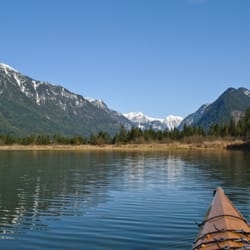
    The Malcolm Knapp Research Forest located in Maple Ridge BC is a plot of land owned by UBC to train…read moretheir students in their forestry programs. This Research forest is also open to the public all year long for walking only (no bikes or dogs aloud!). There are 4 loop trails located in the forest as well as many many km or logging roads to explore. If you go far enough on some of the logging roads you can gain a view of Pit Lake far below. There are also options of following logging roads into Golden Ears Provincial Park near Mike Lake. While hiking here you may hear very large trees being cut down and it may be a little unnerving (It made me jump a little bit) but this is just the forestry students learning. If it is unsafe to be on a road or trail due to this activity they will close It! For that reason do not go past trail closed signs if you see them! If you visit the forest during the week you may be able to pick up a copy of the trail map from the front office as they are usually open.

    This forest revels in its beauty it has beautiful green trees and lovely singing birds the birds…read moresing songs that are like golden honey to my ears has many trails the trails are fantastic in their scope and their view I truly love this parking would recommend any nature lover who enjoys the blue skies and maybe the rainy skies here in Vancouver to take a walk in this beautiful park and enjoy all that it has to offer
    Photos
    Malcolm Knapp Research Forest
    Malcolm Knapp Research Forest
    Malcolm Knapp Research Forest

    See all

    Garibaldi Provincial Park

    Garibaldi Provincial Park

    4.8(35 reviews)
    89.1 km

    The hike to Garibaldi Lake! This was a difficult one for me, maybe one of the tougher ones I've…read moreaccomplished and I'm saying that because I'm not the most patient of hikers. I'm more of a speed hiker that likes to get in and get out! But to access Garibaldi Lake, (the obvious main event to the park), you must take the Rubble Creek Trail. It's an 18 kilometer out and back hike (or as us Americans would say - "roundtrip")...that is a length of 11.5 miles long. And with that 11.5 miles, the path is all uphill! Everything about it is uphill until you eventually arrive at...Garibaldi Lake! So...for the folks out there who maybe don't hike often, I'd just suggest preparing for the long haul. The hike will be strenuous, but pace yourself, take breaks when necessary and before long...the reward will be worth the grind! And then, you'll be coming back for more! Another thing, I'm always motivated to capture undisturbed pictures in nature. And it's this inspiration that I use to discover what's out there. I want to reflect back on the experience and know I afforded myself ample time during the day to accomplish the sights and sceneries that make for memorable stories. Lol, it's this type of internal mentality that pushes me to strive for greater heights, so to speak, hehehe. Okay so this Rubble Creek Trail to Garibaldi Lake! You must make a reservation 2 days in advance prior to visiting. Just go to bcparks.ca and sign up for a pass. I also used this website for accessing Joffre Lakes Provincial Park situated in Mount Currie, BC. And btw, this Garibaldi Lake is located just north of Whistler, BC. One side note...the parks, lakes and hikes here in Lower British Columbia are simply fantastic! There's a laundry list of things to do. And especially when you speak to locals and they recommend hidden, under the radar places that the public eye doesn't know much about. I thought the Canadian Rockies in Alberta were stunning, but British Columbia nature is really, really scenic! Before arriving at Garibaldi Lake, I suggest taking a short side trek to Barrier Viewpoint for some quick panoramic looks. Also, along the trail you'll pass over a short bridge looking up at a waterfall. It's worthy of a photo. Finally arriving at Garibaldi Lake, at first it may not be so picturesque (even when the sun is out!) but give it a chance. Walk around and explore and you'll find colorful instances where you'll connect with those green and turquoise blue waters. Especially when you're looking back towards the entrance area of the lake, the return hike back down had some of my most fulfilling pictures of the day. It's weird, it's like the angle of the sun can play tricks on you. Be patient and hopefully magical moments will evolve! I tried to walk around the perimeter of Garibaldi Lake, but that wasn't possible. So...I had to relax a little and take my foot off the gas pedal, lol. In fact, some of my best views were simply looking out at the snowcapped mountain peaks. There's a glacier set in the distance as well. A lot of visitors brought their bathing suits with them. And although the lake is glacially fed and freezing, people were still swimming! I even joined in on the fun and took my clothes down to my underwear and hopped in the waters, lol. Granted, it was only briefly, but still, I wanted to leave no stone unturned while here! I'd also point out that since the lake is not navigable 360 degrees around, it sort of took the pressure off me to find the best picture angles. Instead, I really tried to embrace the setting and live in the moment! There's camping allowed here, but again you must make reservations for it. Btw, it's free to book your entry pass to the lake. Parking is free too. One last thing, remember...when you head back towards the entrance of Garibaldi Lake, you'll be pleasantly surprised with the lake colors illuminating from the tree line pathway. I left the lake around 3pm and suddenly, light greens and blues were evident! There are vault toilets at the lake. Interestingly, they ask you to bring your own toilet paper. Never seen that before. Overall, Garibaldi Lake was a wonderful way to enjoy a summer day in the great outdoors. I can't believe I hiked 18 kilometers. And the path through the forest makes for a quiet atmosphere in the woods. I would still rank Joffre Lakes as my favorite BC landmark, but this Garibaldi Lake has its value and major popularity among hikers. Thank you for taking time to read this.

    All I have to say is be prepared.. As this is about an 18km hike, I recommend leaving early in the…read moremorning and staying over night in Whistler so you don't feel rushed. This time around when we went, due to the pandemic, we had to book a time slot the day of as they were limiting the amount of hikers. Driving there isn't the problem nor is the parking, it's the length of time but the reward at the end is worth it. I recommend bringing a small bag for liquids, snacks, bug spray, hat and towel as you could swim there but keep in mind you can't throw away your garbage at the site due to bears even though there's a camp site there. The hike isn't super steep and you won't have to climb anything (at least I didn't), you just have to be ready to walk a lot. The path is well marked so you can't get lost. I would say the average round trip if you aren't including staying at the destination to eat and take photos is roughly 4-5 hours round trip at a steady pace. Hike's are always calming and it helps clear your mind from stress and clutter. This is probably one of the best local hikes I've done so far and I would definitely recommend it to anything looking for a challenge and beautiful view. And if you want to be more adventurous, you can also extend your trip to panoramic ridge and black tusk!

    Photos
    Garibaldi Provincial Park
    Garibaldi Provincial Park
    Garibaldi Provincial Park - View from Garibaldi Lake campground

    See all

    View from Garibaldi Lake campground

    Mike Lake - hiking - Updated October 2026

    Loading...
    Loading...
    Loading...