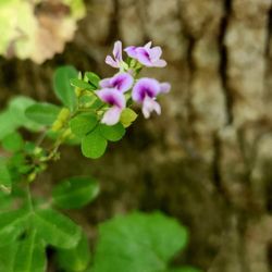
McIntosh Reserve Photos


You might also consider
More like McIntosh Reserve
Recommended Reviews - McIntosh Reserve
Start your review...

Reviews With Photos

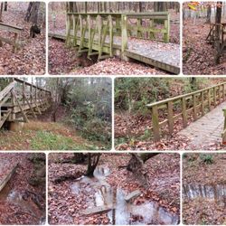
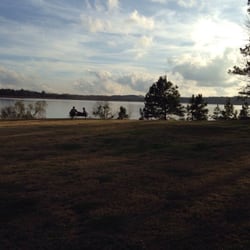
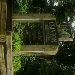
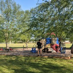
McIntosh Reserve is a park and historical site operated by Carroll County. Free for residents of the county, the cost is only $3 for everyone else. The park is located a few miles south off Hwy 5 just south of the town of Whitesburg. The Chattahoochee River lies on its southern border and is the main feature of the park. The historical part relates to the life and doings of a Creek chief, William McIntosh, who lived and was murdered at his home located on these grounds. There's a log cabin purported to be 'just like the one he lived in', the actual residence having been destroyed at some point. His grave is nearby. There's not much to see at the log cabin. I came here for the hiking, which isn't really what this park does best. There are a good number of trails but an almost total lack of trail markings or maps onsite. The best trails near the river are in fact equestrian paths, which is OK as long as you don't mind the mud the horses churn up and keep an eye out for droppings. On the non-river side of the road, there are more typical walking trails, but, as I said, almost totally unmarked. I found exactly one map in the park showing trails and it was located at an equestrian parking area, which gives you a clue as to the intended purpose of the trails. The visitor entrance did not have one and the old ranger station located at the other end also did not. In fact, the ranger station was unoccupied and had zero information posted outside. For my hike, I tore out the pages of the Atlanta area hiking book which had led me here. It had a map, albeit an inaccurate one. I did a fair bit of wandering trying figure out where I was and where the trails were. The website has a good map showing the trails - click on 'Park Map', not 'Trail Map'. The latter is pretty useless. There were few people in the park when I visited and thus few people using the facilities, but it's apparent that the main attraction is picnicking. The park boasts several pavilions, one with a great river view. There's also what is called a 'water park', although that turns out to be an area near a couple of ponds where vertical spray fountains are installed for the kids to play in. Other than that, the most prominent feature would be acres and acres of mown grass. There is a lot of mown grass here, and even a very large field of unmown grass that serves as a wildlife viewing field. I didn't see any wildlife. The online 'Trail Map' suggests that the large field is used for model airplanes, the mown part of it I would assume. Bottom line, if you're local and need a spot for a large gathering - say a company picnic - McIntosh Reserve is the place to be. The best river views are located in a rather rough-looking picnic area on the other side of the road from the old ranger station at the south end of the park. Here you'll find a pretty scenic overlook. You can walk down to the river from there and continue on for a half mile or so along the river bank until you get to the large wildlife viewing field. As with almost everywhere in this park, you'll also find a bunch of picnic tables as you walk.

5 years ago
January 23, 2021 McIntosh Reserve is about an hour outside of Atlanta in Carroll County, Georgia. It is a a 527 are park home to some rich history and popular amongst equestrians, nature hiking, and boarders the Chattahoochee River and definitely a spot to cool off in the summer. The park has a good website: http://www.carrollcountyga.com/293/McIntosh-Reserve-Park I would take a peek at the events calendar. Would be nice to see some music festivals here. The River ran swiftly while we were visiting, and there is plenty of space to picnic or grill on the premises with park benches and covered seating under a nice pavilion. The park happened to host the Jerome Scales 10k race held by the Atlanta Track Club on this day, which is why we were here. (Otherwise I might never have know about it.) We had a parking pass and entered the park, and were directed to park on a wide field. Went down to register and obtain our bibs at around 7:30am on a chilly morning. Thankfully we had a cloudless sky and the promise of a a sunny morning. The races began at 8am with 20 socially distanced athletes wearing masks setting off every 5 minutes. My time slot was 8:20 and Nicole was at 9:05 which was perfect because we could both race! The course was completed in 2.5 loops with 50% grass, 33% hard pack gravel, and 17% roads with a good hill. I was happy to come in 3rd overall. Nicole ran a slightly less competitive time but had fun too. History: The Reserve is named for William McIntosh, Jr., a prominent Creek Indian leader and planter. The plantation was known as Lochau Talofau, which in English means "Acorn Bluff". It is adjacent to Acorn Creek. McIntosh lived in a modest home, a two-story log house with a central, open "dog run" passage on both floors. The house doubled as an inn for travelers. A reconstructed house is open to park visitors today. In 1825, McIntosh signed the second Treaty of Indian Springs. The treaty essentially sold all Creek lands in Georgia and Alabama to the United States government; McIntosh was allowed to keep his plantation in exchange for signing the treaty. The treaty had been opposed by the Creek National Council and it violated the Law, the Code of 1818. The Council ordered the execution of McIntosh and other signatories for having committed a capital offense against the government by ceding communal lands, and he was executed at his home in 1825. McIntosh's single-plot, military grave may be found just across the road from the reconstructed house. Carroll County acquired Lochau Talofau in 1978; the plantation now lies within McIntosh Reserve boundaries.[1] McIntosh Reserve Park was closed for several months in 2009 and 2010, following the September 2009 flooding on the Chattahoochee River. The park was scheduled to reopen for Memorial Day weekend, 2010. Looking forward to our next visit. read more


3 years ago
3 years ago
McIntosh Reserve is a park and historical site operated by Carroll County. Free for residents of the county, the cost is only $3 for everyone else. The park is located a few miles south off Hwy 5 just south of the town of Whitesburg. The Chattahoochee River lies on its southern border and is the main feature of the park. The historical part relates to the life and doings of a Creek chief, William McIntosh, who lived and was murdered at his home located on these grounds. There's a log cabin purported to be 'just like the one he lived in', the actual residence having been destroyed at some point. His grave is nearby. There's not much to see at the log cabin. I came here for the hiking, which isn't really what this park does best. There are a good number of trails but an almost total lack of trail markings or maps onsite. The best trails near the river are in fact equestrian paths, which is OK as long as you don't mind the mud the horses churn up and keep an eye out for droppings. On the non-river side of the road, there are more typical walking trails, but, as I said, almost totally unmarked. I found exactly one map in the park showing trails and it was located at an equestrian parking area, which gives you a clue as to the intended purpose of the trails. The visitor entrance did not have one and the old ranger station located at the other end also did not. In fact, the ranger station was unoccupied and had zero information posted outside. For my hike, I tore out the pages of the Atlanta area hiking book which had led me here. It had a map, albeit an inaccurate one. I did a fair bit of wandering trying figure out where I was and where the trails were. The website has a good map showing the trails - click on 'Park Map', not 'Trail Map'. The latter is pretty useless. There were few people in the park when I visited and thus few people using the facilities, but it's apparent that the main attraction is picnicking. The park boasts several pavilions, one with a great river view. There's also what is called a 'water park', although that turns out to be an area near a couple of ponds where vertical spray fountains are installed for the kids to play in. Other than that, the most prominent feature would be acres and acres of mown grass. There is a lot of mown grass here, and even a very large field of unmown grass that serves as a wildlife viewing field. I didn't see any wildlife. The online 'Trail Map' suggests that the large field is used for model airplanes, the mown part of it I would assume. Bottom line, if you're local and need a spot for a large gathering - say a company picnic - McIntosh Reserve is the place to be. The best river views are located in a rather rough-looking picnic area on the other side of the road from the old ranger station at the south end of the park. Here you'll find a pretty scenic overlook. You can walk down to the river from there and continue on for a half mile or so along the river bank until you get to the large wildlife viewing field. As with almost everywhere in this park, you'll also find a bunch of picnic tables as you walk. read more


2 years ago
10 years ago
Really nice lady at the entrance...she took our $5 for the park entrance. The boat dock is clean and easy tenter. There are lots of tent sights. Plus it's dog friendly. We need to buy us a tent! read more


10 years ago
More info about McIntosh Reserve
1046 W Mcintosh Cir
Whitesburg, GA 30185
Directions
(770) 830-5879
Call Now
Hours
Outdoor Amenities
Ask the Community - McIntosh Reserve


Why does Yelp recommend reviews?
1 review that is not currently recommended
The reviews below are not factored into the business's overall star rating.
10 years ago
McIntosh Reserve - parks - Updated May 2026
Best of Whitesburg
People found McIntosh Reserve by searching for…
Water Parks in Whitesburg, Georgia
Fishing in Whitesburg, Georgia
Campgrounds in Whitesburg, Georgia
Fishing Spots in Whitesburg, Georgia
Playgrounds in Whitesburg, Georgia
Fun Things to Do in Whitesburg, Georgia
Splash Pad in Whitesburg, Georgia
Off Road Trails in Whitesburg, Georgia
Picnic Areas in Whitesburg, Georgia
Fishing Lake in Whitesburg, Georgia
Walking Trails in Whitesburg, Georgia
Scenic View in Whitesburg, Georgia
Places to Take Pictures in Whitesburg, Georgia
River Swimming in Whitesburg, Georgia
Hiking Trails in Whitesburg, Georgia
Scenic Overlook in Whitesburg, Georgia
Free Things to Do in Whitesburg, Georgia
Running Tracks Open to the Public in Whitesburg, Georgia
Scenic Drive in Whitesburg, Georgia
Lakes & Ponds in Whitesburg, Georgia
Photo Spots in Whitesburg, Georgia
Trending Searches in Whitesburg, GA
Baseball Fields near McIntosh Reserve
Botanical Gardens near McIntosh Reserve
Bounce House Rentals near McIntosh Reserve
Campgrounds near McIntosh Reserve
Cliff Jumping near McIntosh Reserve
Dog Friendly Things To Do near McIntosh Reserve
Fishing Lake near McIntosh Reserve
Flower Shop near McIntosh Reserve
Free Picnic Areas near McIntosh Reserve
Garage Sales near McIntosh Reserve
Garden Center near McIntosh Reserve
Nurseries & Gardening near McIntosh Reserve
Outdoor Basketball Courts near McIntosh Reserve
Outdoor Furniture Stores near McIntosh Reserve
Party Equipment Rentals near McIntosh Reserve
Pedicure near McIntosh Reserve
Pick Your Own Farms near McIntosh Reserve
Places To Take Pictures near McIntosh Reserve
Plant Nursery near McIntosh Reserve
Rock Quarry near McIntosh Reserve
Scenic Drive near McIntosh Reserve
Splash Pad near McIntosh Reserve
Strawberry Picking near McIntosh Reserve
Swimming Holes near McIntosh Reserve
Table And Chair Rentals near McIntosh Reserve
Browse Brands
Related Searches in Whitesburg, GA
Best Fishing Locations and Guides in Whitesburg, Georgia
Best Fun Things to Do in Whitesburg, Georgia
Best Parks for Parties and Events in Whitesburg, Georgia
Best Water Parks for Kids in Whitesburg, Georgia
Check Out Great Playgrounds in Whitesburg, Georgia
Check Out Off Road Trails in Whitesburg, Georgia
Discover Baseball Fields Around Whitesburg, Georgia
Discover Fun Activities to Do in Whitesburg, Georgia
Discover Kids Indoor Play Area Venues in Whitesburg, Georgia
Discover Lakes & Ponds to Explore in Whitesburg, Georgia
Discover Popular Photo Spots in Whitesburg, Georgia
Discover Soccer Fields in Whitesburg, Georgia Near You
Discover Top Nature Parks to Visit in Whitesburg, Georgia
Discover the Best Beaches in Whitesburg, Georgia
Enjoy the Best Walking Trails in Whitesburg, Georgia
Explore Beautiful Botanical Gardens in Whitesburg, Georgia
Explore Family-Friendly Zoos and Wildlife in Whitesburg, Georgia
Explore Free Picnic Areas Around Whitesburg, Georgia
Explore Outdoor Basketball Courts for All Skill Levels in Whitesburg, Georgia
Explore Parks With Pull Up Bars in Whitesburg, Georgia
Explore Popular Picnic Areas Around Whitesburg, Georgia
Explore Popular RV Parks Around Whitesburg, Georgia
Explore Popular Recreation Centers Around Whitesburg, Georgia
Explore Popular Scenic Views Near Whitesburg, Georgia
Explore Popular View Points Around Whitesburg, Georgia
Explore Scenic Lakes to Visit in Whitesburg, Georgia
Explore Secret Spots Worth Visiting in Whitesburg, Georgia
Explore Top Dog Parks in Whitesburg, Georgia Near You
Explore Top Gyms in Whitesburg, Georgia Now
Explore Volleyball Courts Available in Whitesburg, Georgia
Explore the Best Swimming Holes Around Whitesburg, Georgia
Find Beautiful Views in Whitesburg, Georgia
Find Parks and Recreation Activities in Whitesburg, Georgia
Find Public Tennis Courts in Whitesburg, Georgia
Find Top Skating Rinks in Whitesburg, Georgia for All Ages
Find Top-Rated Waterfalls in Whitesburg, Georgia Now
Find a Park With BBQ Pits in Whitesburg, Georgia
Find the Best Parks BBQ Grills in Whitesburg, Georgia
Find the Best Parks for Picnics in Whitesburg, Georgia
Find the Best Swimming Pools in Whitesburg, Georgia Today
Great Places to Swim in Whitesburg, Georgia
Hiking Trails With Waterfalls in Whitesburg, Georgia
Must-See Tourist Attractions Around Whitesburg, Georgia
Plan a Scenic Drive Route Near Whitesburg, Georgia
Popular Fishing Spots to Explore in Whitesburg, Georgia
Popular Places to Take Pictures in Whitesburg, Georgia
Top Hiking Trails to Explore in Whitesburg, Georgia
Top Running Trails to Explore in Whitesburg, Georgia
Top-Rated Basketball Courts to Play at in Whitesburg, Georgia