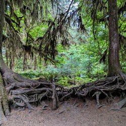
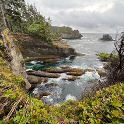
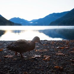
Maple Pass Loop Photos


More like Maple Pass Loop
Recommended Reviews - Maple Pass Loop
Start your review...

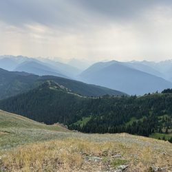
Maple Pass Loop is a rewarding hike and one that will be remembered for a very long time. You can approach the loop clockwise or counter-clockwise. Most people choose to go counter-clockwise because you start with a more gradual ascent. Clockwise starts out with a steep 3.2 mile climb with a 2000 plus elevation gain. My group decided to go clockwise and we were rewarded with incredible beauty. The views along the way are stunning and once you reach the top it's breathtaking. The second part of the loop is much easier. The descent is smooth and the views are also amazing....but it's long. The trail is listed as a 6.6 mile hike but completed it is about 8.2. miles. read more


More info about Maple Pass Loop
Forks, WA 98331
Directions
Hours
Outdoor Amenities


Maple Pass Loop - hiking - Updated June 2026
Best of Forks
People found Maple Pass Loop by searching for…
Things to Do in Forks, Washington
Hiking Trails in Forks, Washington
Beautiful Views in Forks, Washington
View Points in Forks, Washington
Things to Do at Night in Forks, Washington
Places to Visit in Forks, Washington
Stuff to Do in Forks, Washington
Swimming Holes in Forks, Washington
Walking Trails in Forks, Washington
Restaurants in Forks, Washington
Off Road Trails in Forks, Washington
Adventure in Forks, Washington
Scenic View in Forks, Washington
Running Trails in Forks, Washington
Waterfalls in Forks, Washington
Watch Sunset in Forks, Washington
Scenic Spots in Forks, Washington
Lookout Points in Forks, Washington
Sunrise View in Forks, Washington
Trending Searches in Forks, WA
Bait And Tackle Shop near Maple Pass Loop
Boat Rental near Maple Pass Loop
Dog Friendly Trails near Maple Pass Loop
Fishing Spots near Maple Pass Loop
Public Shower near Maple Pass Loop
Sunrise View near Maple Pass Loop
Swimming Holes near Maple Pass Loop
Swimming Lakes near Maple Pass Loop
Browse Articles
Browse Nearby
BEST of Forks, Washington Parks near Maple Pass Loop
BEST of Forks, Washington Restaurants near Maple Pass Loop
BEST of Forks, Washington Things to Do near Maple Pass Loop
BEST of Forks, Washington Coffee near Maple Pass Loop
BEST of Forks, Washington Scenic View near Maple Pass Loop
BEST of Forks, Washington Hot Springs near Maple Pass Loop
BEST of Forks, Washington Campgrounds near Maple Pass Loop
Browse Brands
Related Searches in Forks, WA
Best Fishing Locations and Guides in Forks, Washington
Best Fun Things to Do in Forks, Washington
Best Nature Trails for Hiking in Forks, Washington
Best Places for Horseback Riding in Forks, Washington
Best Waterfalls and Swimming Holes in Forks, Washington
Check Out Off Road Trails in Forks, Washington
Discover Dog Friendly Trails to Explore in Forks, Washington
Discover Popular Bike Trails in Forks, Washington
Discover Top Boat Tours in Forks, Washington for All Ages
Discover Top Nature Parks to Visit in Forks, Washington
Discover a Hiking Trail in Forks, Washington
Discover the Best Night Hike Trails in Forks, Washington
Discover the Best Tide Pools in Forks, Washington
Enjoy Camping Adventures Around Forks, Washington
Enjoy Exciting Mountain Biking Adventures in Forks, Washington
Enjoy Kayaking Adventures in Forks, Washington
Enjoy Tent Camping Spots Around Forks, Washington
Enjoy the Best Walking Trails in Forks, Washington
Exciting Cliff Jumping Spots in Forks, Washington
Explore Beautiful Parks and Green Spaces in Forks, Washington
Explore Bike Rentals Throughout Forks, Washington
Explore Easy Hikes Perfect for All in Forks, Washington
Explore Popular Campgrounds Near Forks, Washington
Explore Popular RV Parks Around Forks, Washington
Explore Popular Scenic Overlook Points in Forks, Washington
Explore Scenic Lakes to Visit in Forks, Washington
Explore Top Dog Parks in Forks, Washington Near You
Explore Whale Watching Tours in Forks, Washington
Explore the Best Beach Spots in Forks, Washington
Explore the Best Swimming Holes Around Forks, Washington
Family Friendly Hiking With Kids in Forks, Washington
Find the Best Parks for Picnics in Forks, Washington
Find the Best Swimming Pools in Forks, Washington Today
Hiking Trails With Waterfalls in Forks, Washington
Locate a Public Shower Facility in Forks, Washington
Must-See Tourist Attractions Around Forks, Washington
Perfect Spots to Watch Sunset in Forks, Washington
Popular Fishing Spots to Explore in Forks, Washington
Popular Kids Activities in Forks, Washington
Popular Outdoor Activities to Try in Forks, Washington
Popular Picnic Spots to Visit in Forks, Washington
Popular Places to Take Pictures in Forks, Washington
Popular Things to Do in Forks, Washington
Popular Things to See in Forks, Washington
Relax at Natural Hot Springs Near Forks, Washington
Top Fishing Charter Experiences in Forks, Washington
Top Running Trails to Explore in Forks, Washington
Top Things to Do With Kids in Forks, Washington