Lake Hickory Trails Photos


You might also consider
More like Lake Hickory Trails
Recommended Reviews - Lake Hickory Trails
Start your review...

3 years ago
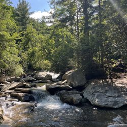
Took some additional photos today on our walk. More and more residents are learning about the trails. If you are looking for a great place to get some fresh air and exercise, these trails are for you! The updates to the Riverwalk sections are beautiful. read more


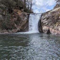
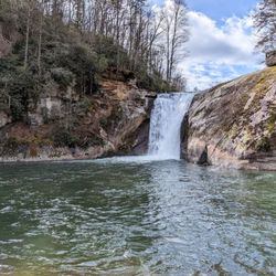
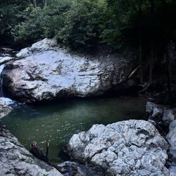
7 years ago
More info about Lake Hickory Trails


Lake Hickory Trails - mountainbiking - Updated July 2026
Best of Hickory
People found Lake Hickory Trails by searching for…
Parks in Hickory, North Carolina
Secret Spots in Hickory, North Carolina
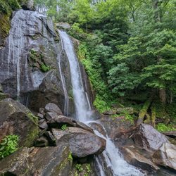
Hiking Trails With Waterfalls in Hickory, North Carolina
Things to Do in Hickory, North Carolina
Picnic Areas in Hickory, North Carolina
Walking Trails in Hickory, North Carolina
Off Road Trails in Hickory, North Carolina
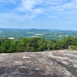
Scenic View in Hickory, North Carolina
Easy Hikes in Hickory, North Carolina
What to Do in Hickory, North Carolina
Photo Spots in Hickory, North Carolina
Lakes & Ponds in Hickory, North Carolina
Waterfalls in Hickory, North Carolina
Picnic Spots in Hickory, North Carolina
Stroller Friendly Hikes in Hickory, North Carolina
Running Trails in Hickory, North Carolina
Secluded Spots in Hickory, North Carolina
Places to Visit in Hickory, North Carolina
Swimming Holes in Hickory, North Carolina
Places to Take Pictures in Hickory, North Carolina
Dog Hiking Trails in Hickory, North Carolina
Splash Pad in Hickory, North Carolina
Trending Searches in Hickory, NC
Black Owned Nail Salons near Lake Hickory Trails
Boat Rental near Lake Hickory Trails
Cliff Jumping near Lake Hickory Trails
Day Trips near Lake Hickory Trails
Dog Friendly Trails near Lake Hickory Trails
Dog Swimming near Lake Hickory Trails
Jet Ski Rental near Lake Hickory Trails
Kayak Rental near Lake Hickory Trails
Lakes & Ponds near Lake Hickory Trails
Lookout Points near Lake Hickory Trails
Mountain Biking near Lake Hickory Trails
Off Road Trails near Lake Hickory Trails
Outdoor Activities near Lake Hickory Trails
Parks near Lake Hickory Trails
Picnic Spots near Lake Hickory Trails
Public Pools near Lake Hickory Trails
Public Shower near Lake Hickory Trails
River Swimming near Lake Hickory Trails
River Tubing near Lake Hickory Trails
Scenic Night View near Lake Hickory Trails
Scenic Overlook near Lake Hickory Trails
Secluded Spots near Lake Hickory Trails
Soccer Store near Lake Hickory Trails
Splash Pad near Lake Hickory Trails
Star Gazing near Lake Hickory Trails
Strawberry Picking near Lake Hickory Trails
Sunrise View near Lake Hickory Trails
Swimming Holes near Lake Hickory Trails
Swimming Lakes near Lake Hickory Trails
Watch Sunset near Lake Hickory Trails
Water Parks near Lake Hickory Trails
Browse Nearby
BEST of Hickory, North Carolina Restaurants near Lake Hickory Trails
BEST of Hickory, North Carolina Coffee near Lake Hickory Trails
BEST of Hickory, North Carolina Things to Do near Lake Hickory Trails
BEST of Hickory, North Carolina Breakfast near Lake Hickory Trails
BEST of Hickory, North Carolina Lakes near Lake Hickory Trails
BEST of Hickory, North Carolina Shopping near Lake Hickory Trails
Browse Brands
Related Searches in Hickory, NC
Affordable Bike Tune Up Services in Hickory, North Carolina
Affordable Kayak Rental Services in Hickory, North Carolina
Best Dirt Bike Riding Spots in Hickory, North Carolina
Best Dog Hiking Trails Around Hickory, North Carolina
Best Electric Bike Rental Services in Hickory, North Carolina
Best Fishing Locations and Guides in Hickory, North Carolina
Best Lookout Points to Visit in Hickory, North Carolina
Best Nature Trails for Hiking in Hickory, North Carolina
Best Places for Horseback Riding in Hickory, North Carolina
Best Sledding Spots and Fun in Hickory, North Carolina
Best Used Bikes for Sale Near Hickory, North Carolina
Best Waterfalls and Swimming Holes in Hickory, North Carolina
Check Out Off Road Trails in Hickory, North Carolina
Discover Popular Bike Tours in Hickory, North Carolina
Discover Popular Bike Trails in Hickory, North Carolina
Discover Scenic Mountain Bike Trails Near Hickory, North Carolina
Discover Top Boat Tours in Hickory, North Carolina for All Ages
Discover a Hiking Trail in Hickory, North Carolina
Discover the Best Night Hike Trails in Hickory, North Carolina
Dog-Friendly Hikes With Dogs in Hickory, North Carolina
Enjoy Exciting Mountain Biking Adventures in Hickory, North Carolina
Enjoy Hiking Adventures in Hickory, North Carolina
Enjoy River Tubing Adventures in Hickory, North Carolina
Enjoy Scenic Night View Experiences in Hickory, North Carolina
Enjoy Tent Camping Spots Around Hickory, North Carolina
Enjoy the Best Tubing Experiences in Hickory, North Carolina
Enjoy the Best Walking Trails in Hickory, North Carolina
Exciting Cliff Jumping Spots in Hickory, North Carolina
Exciting Snow Tubing Experiences in Hickory, North Carolina
Experience Thrilling White Water Rafting in Hickory, North Carolina
Explore Beautiful Parks and Green Spaces in Hickory, North Carolina
Explore Bike Rentals Throughout Hickory, North Carolina
Explore Easy Hikes Perfect for All in Hickory, North Carolina
Explore Electric Bikes Available in Hickory, North Carolina
Explore Fun Activities to Do in Hickory, North Carolina
Explore Popular Campgrounds Near Hickory, North Carolina
Explore Popular Scenic Overlook Points in Hickory, North Carolina
Explore Popular View Points Around Hickory, North Carolina
Explore Scenic Lakes to Visit in Hickory, North Carolina
Explore Secret Spots Worth Visiting in Hickory, North Carolina
Explore Top Dog Parks in Hickory, North Carolina Near You
Explore Top Water Parks in Hickory, North Carolina Today
Explore the Best Boating Spots in Hickory, North Carolina
Explore the Best Swimming Holes Around Hickory, North Carolina
Explore the Best Trail Options in Hickory, North Carolina
Family Friendly Hiking With Kids in Hickory, North Carolina
Find Beautiful Views in Hickory, North Carolina
Find Cozy Camping Cabins in Hickory, North Carolina
Find Parks and Recreation Activities in Hickory, North Carolina
Browse Articles
People who viewed Lake Hickory Trails also viewed
Bakers Mountain Park
12 reviews
Geitner-Rotary Park
5 reviews
South Mountains State Park
51 reviews
Riverbend Park
7 reviews
Glenn C Hilton Jr. Memorial Park
14 reviews
Rocky Face Mountain Recreational Area
14 reviews
Lake James State Park
28 reviews
Heritage Trail Greenway
2 reviews
Ivey Arboretum at Sally Fox Park
1 review
Claremont Park
1 review