Kern River Parkway Hiking Photos


You might also consider
More like Kern River Parkway
Recommended Reviews - Kern River Parkway
Start your review...

Reviews With Photos

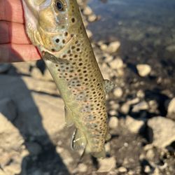
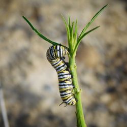
The Kern River Parkway is my favorite place to exercise whenever I visit Bakersfield. I like that it's in walking distance from where I stay and it's easy to use the path for walking, running, riding a bike or roller blading. I like that there are several signs mile marker signs posted in case you're keeping track. The parkway path is paved and there is also an option to run on the unpaved Tuhohi trail run path trails if you want to. In addition to using the parkway to run, walk, bike, or skate, people also visit the parkway to engage in activities such as fishing, play disc golf, playing volleyball or meeting up to do boot camp classes. Although I have used this path numerous times, I was surprised to read the various monuments highlighting the impact of Native Americans in Bakersfield. The only sad thing about the Kern River Parkway is that there is lots of trash on the ground in some areas of the parkway path as well as some areas where you can see that homeless people are camping out in the woods. As long as you avoid these areas, you will have an enjoyable experience at the parkway. Overall, visiting the Kern River Parkway is a great way to stay connect with nature of a regular basis as well as wonderful opportunity to move one's body in a car of ways.

Raise your hand if you like to exercise! Did you raise your hand? No? Neither did I. Unfortunately, exercise is a good thing that we need to do if we want to be or get in shape. The Kern River Parkway provides a great trail to get some much needed exercise. It is approximately 20 miles long. We never bike on the Kern River Parkway unlike the majority of folks. We prefer walking or jogging along a 5 mile stretch of the trail. Of course, we make sure to stay out of the way of the cyclists. I've seen some folks get really pissed off at pedestrians walking along the path close to the Park at Riverwalk. Anyhow, there are multiple points of entry onto the Kern River Parkway. Many parks along the parkway as well. We prefer entering the KRP from the Park at Riverwalk. I think it is the nicest and shadiest area of the Kern River Parkway. Other parts of the trail can get a bit desolate. The west side of the Parkway past Allen Rd. all the way to Enos Lane is not too crowded because there are less folks walking or jogging. Also be on the lookout for bobcats or other wildllife. Heading East past Truxton, one should also keep an eye out for wildlife and vagrants. Best to be riding, walking, or jogging with a friend or two or three. For the most part, though, the Kern River Parkway is terrific! So glad to have it in Kern County!! Thank you to all who help maintain this cool place!!

I love running and I am so glad that Bakersfield has a safe running area with no motor vehicles nor traffic lights in your way. Parkway extends from East to West and I love that it is reasonably accessible no matter which side of town you live in. There would be more people using the area on weekends but there is definitely enough space for social distancing. It could get pretty hot in the summer especially since there is minimal shade from trees so I would suggest waking up a little bit earlier to enjoy the place. I would not suggest using the pathway alone at night since it is not a lit path. But still, I'm rating it a 5 because it gives a good option for people who want to workout away from the the house or outside the gym.


I ride my bike several here several times a week. Easy accessibility right off Mohawk and Truxtun. It's a nice central starting point to get to the bike trail. I meet here with my father and away we ride.... Friendly people frequent the trail and it's nice to see active people enjoying the sunshine. There is plenty of parking. Nice, big grass areas and trees. This place needs a name change though. The river has been dry as a bone for at least 10 years. No sign of a river just a dry, barren and sandy river bed. I will try to get more pictures soon. Kern River Parkway, 5 stars.

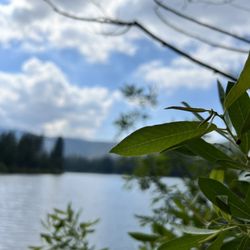
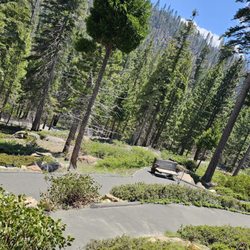
Wow, did Bakersfield's community leaders really have it together to preserve the Kern River for its citizens back in the 80s. This park is one of my most favorite things about Bakersfield. It is truly a local gem. It's a claim that most cities can't make - a 20-mile linear park abutting the Kern River running through the middle of the city from one end to the other with a bike path, tons of recreation areas, hundreds of flora and fauna in natural state among other things. The park stretches from Lake Ming in the upper northeast foothills following the river through central Bakersfield, past the oil refineries, office park high-rises, Truxtun Lake, and southwest suburban tract homes before ending at the farmland landscape at Enos Lane in the far southwest. A nice and apt cross-section of Bakersfield if you ask me. I've jogged, biked, rollerbladed, played beach volleyball, BBQed, and fished (among other things, snicker) in this park more times than I can count, and I love it more each and every time.

3 years ago


I cycle all over the USA and some other countries, so last Sunday thankfully I was able to travel to Bakersfield to cycle the 20 mile (40 mile RT) paved Kern River Parkway Bike Trail I heard so much about. First I just have to say that the other cyclists I met on the trail here was so friendly that I thought that I was in Louisiana. What I mean is that when I am cycling in Irvine, Newport Beach or Santa Monica where I ride most of the time, less than 5% of other cyclists will say hello to you and less than 5% of other cyclists will respond if you say hello to them. But in Bakersfield, at least 75% of the cyclists that I past on the path said hello to me!! I could not believe it! I did not know what was going on? I was not used to that hospitality. What do they put in the water in Bakersfield? Maybe they all knew I was not from the City so they were being friendly--they probably all knew one another? It was a weird contrasting experience to life in LA. Anyway--I can write a book about my day on the Trail but will keep it concise: I parked at the River Walk Park which is located at 11298 Stockdale Hwy, 93311 (for those not from the city). Or you can can park at the outdoor shopping mall next door that has lot's of restaurants and a Target. (Don't park in front of any stores to bike ride--park in the middle or back.) From here, I first road the Trail West 9 miles to the end point. It's a lonely desolate stretch--I have never ridden anywhere where I was so alone for miles with no roads or cars. You can ride as fast as you want over here and bother no one. Every so often I came across someone. I did see a few single men and women riding alone that made me feel better. Then I returned to the River Walk Park--had lunch at the car from my cooler and then traveled East on the Path to the end. The East section passes bike stores, exit Coffee Road (which comes up right away) for Trader Joe's or Sully's Convenience Store or Starcrooks. You pass many parks and lakes and some restrooms. I saw on the East section of the path along the Kern River an Ecological Disaster with tons of garbage all over the river bed, graffiti, and homeless camping for endless miles. Some of the homeless were so entrenched that they had well developed tents, backyards, dogs, and even hanging clothes up to dry as if they have been living there for a long time. There were certain sections that were either scary or disconcerting riding the path alone. I felt like I needed to bring a handgun for protection to do this ride. As nice as it was having 20 miles of no car, well paved bike path in each direction, I am not sure I would do this ride again alone--I would if I returned with a riding partner. I gave the path 5 stars out of respect for Bakersfield years ago taking the planning time and resources to build a great bike and walking trail for the public. But what I saw going on along at least 8 miles of that path was an absolute disgrace that if was in charge of this city I would not tolerate for a second. I would fight every legal battle to return that River bed and it's adjacent areas to the condition it was 20 years ago. You do not have a right to set up residence in a public area. What I saw will cost tax payers Billions of Dollars in environmental cleanup. And yes, here is LA this is a problem too. Overall it was a Great day in Bakersfield--I can tell some of the best people in California live here. read more


The Kern River Parkway is my favorite place to exercise whenever I visit Bakersfield. I like that it's in walking distance from where I stay and it's easy to use the path for walking, running, riding a bike or roller blading. I like that there are several signs mile marker signs posted in case you're keeping track. The parkway path is paved and there is also an option to run on the unpaved Tuhohi trail run path trails if you want to. In addition to using the parkway to run, walk, bike, or skate, people also visit the parkway to engage in activities such as fishing, play disc golf, playing volleyball or meeting up to do boot camp classes. Although I have used this path numerous times, I was surprised to read the various monuments highlighting the impact of Native Americans in Bakersfield. The only sad thing about the Kern River Parkway is that there is lots of trash on the ground in some areas of the parkway path as well as some areas where you can see that homeless people are camping out in the woods. As long as you avoid these areas, you will have an enjoyable experience at the parkway. Overall, visiting the Kern River Parkway is a great way to stay connect with nature of a regular basis as well as wonderful opportunity to move one's body in a car of ways. read more


5 years ago
Raise your hand if you like to exercise! Did you raise your hand? No? Neither did I. Unfortunately, exercise is a good thing that we need to do if we want to be or get in shape. The Kern River Parkway provides a great trail to get some much needed exercise. It is approximately 20 miles long. We never bike on the Kern River Parkway unlike the majority of folks. We prefer walking or jogging along a 5 mile stretch of the trail. Of course, we make sure to stay out of the way of the cyclists. I've seen some folks get really pissed off at pedestrians walking along the path close to the Park at Riverwalk. Anyhow, there are multiple points of entry onto the Kern River Parkway. Many parks along the parkway as well. We prefer entering the KRP from the Park at Riverwalk. I think it is the nicest and shadiest area of the Kern River Parkway. Other parts of the trail can get a bit desolate. The west side of the Parkway past Allen Rd. all the way to Enos Lane is not too crowded because there are less folks walking or jogging. Also be on the lookout for bobcats or other wildllife. Heading East past Truxton, one should also keep an eye out for wildlife and vagrants. Best to be riding, walking, or jogging with a friend or two or three. For the most part, though, the Kern River Parkway is terrific! So glad to have it in Kern County!! Thank you to all who help maintain this cool place!! read more


6 years ago
I love running and I am so glad that Bakersfield has a safe running area with no motor vehicles nor traffic lights in your way. Parkway extends from East to West and I love that it is reasonably accessible no matter which side of town you live in. There would be more people using the area on weekends but there is definitely enough space for social distancing. It could get pretty hot in the summer especially since there is minimal shade from trees so I would suggest waking up a little bit earlier to enjoy the place. I would not suggest using the pathway alone at night since it is not a lit path. But still, I'm rating it a 5 because it gives a good option for people who want to workout away from the the house or outside the gym. read more


7 years ago
It was a very hot day at 105 degrees so it wasn't the best day to take a walk to see the lake. The bike path is in perfect condition but the city needs to add some benches lakeside. read more

I ride my bike several here several times a week. Easy accessibility right off Mohawk and Truxtun. It's a nice central starting point to get to the bike trail. I meet here with my father and away we ride.... Friendly people frequent the trail and it's nice to see active people enjoying the sunshine. There is plenty of parking. Nice, big grass areas and trees. This place needs a name change though. The river has been dry as a bone for at least 10 years. No sign of a river just a dry, barren and sandy river bed. I will try to get more pictures soon. Kern River Parkway, 5 stars. read more


Wow, did Bakersfield's community leaders really have it together to preserve the Kern River for its citizens back in the 80s. This park is one of my most favorite things about Bakersfield. It is truly a local gem. It's a claim that most cities can't make - a 20-mile linear park abutting the Kern River running through the middle of the city from one end to the other with a bike path, tons of recreation areas, hundreds of flora and fauna in natural state among other things. The park stretches from Lake Ming in the upper northeast foothills following the river through central Bakersfield, past the oil refineries, office park high-rises, Truxtun Lake, and southwest suburban tract homes before ending at the farmland landscape at Enos Lane in the far southwest. A nice and apt cross-section of Bakersfield if you ask me. I've jogged, biked, rollerbladed, played beach volleyball, BBQed, and fished (among other things, snicker) in this park more times than I can count, and I love it more each and every time. read more


7 years ago
5 years ago
A friend took me to play disc golf today at this park I had never been to. I believe there were 18 "holes" set up with the baskets. Super fun sport (frisbee and golf combined) and it was great exercise to walk it all. The dry riverbed is right there as is the bike path and a very busy roadway right beside it on the other side (Truxton) It made disc golf a bit hazardous as no one wants to hit a person, car or bike. (phew, this beginner hit nothing but a few trees, unavoidable on this course) The park was quiet on a weekday, and the grounds were very well taken care of. There was even an adult work out area to promote good health! A few transients passing through here and there, made me a little leery of leaving my car out of eyeshot but all turned out fine in that regard (take all your valuables with you, as always). As 4pm came, there was a lot more traffic through the park. Lots and lots of trees stand tall here and cute little squirrels, (mommas and babies) were sunning themselves and running about. Rabbits present too and lots of birds. It was a beautiful day and some people had come just to read a book or take a nap under a tree. Clean, for the most part. read more

4 years ago
7 years ago
9 years ago
14 years ago
12 years ago
11 years ago
8 years ago
17 years ago
10 years ago
12 years ago
More info about Kern River Parkway
6000 Truxtun Ave
Bakersfield, CA 93309
Directions
Hours
Outdoor Amenities
Ask the Community - Kern River Parkway
I use inline skates, is there lots of rocks along this location or is it primarily smooth?
Smooth!
Review Highlights - Kern River Parkway
You might also consider


Why does Yelp recommend reviews?
Kern River Parkway - hiking - Updated May 2026
Best of Bakersfield
People found Kern River Parkway by searching for…
Parks in Bakersfield, California
Beaches in Bakersfield, California
Places to Take Pictures in Bakersfield, California
Things to Do in Bakersfield, California
Lakes in Bakersfield, California
Fishing in Bakersfield, California
Beautiful Views in Bakersfield, California
Volleyball Courts in Bakersfield, California
Campgrounds in Bakersfield, California
Natural Hot Springs in Bakersfield, California
Night Hike in Bakersfield, California
River Walk in Bakersfield, California
State Park in Bakersfield, California
Parks and Recreation in Bakersfield, California
River in Bakersfield, California
Places to Walk in Bakersfield, California
Hiking With Kids in Bakersfield, California
Sunset in Bakersfield, California
Bike Path in Bakersfield, California
Jogging Trails in Bakersfield, California
Parks for Pictures in Bakersfield, California
Parks With Workout Equipment in Bakersfield, California
Trending Searches in Bakersfield, CA
Bird Sanctuary near Kern River Parkway
Boat Rental near Kern River Parkway
Botanical Gardens near Kern River Parkway
Bounce House Rentals near Kern River Parkway
Campgrounds near Kern River Parkway
Cheap Plants near Kern River Parkway
Cherry Picking near Kern River Parkway
Cliff Jumping near Kern River Parkway
Floral Designers near Kern River Parkway
Flower Shop near Kern River Parkway
Garden Center near Kern River Parkway
Lakes & Ponds near Kern River Parkway
Nurseries & Gardening near Kern River Parkway
Outdoor Activities near Kern River Parkway
Outdoor Furniture Stores near Kern River Parkway
Party Equipment Rentals near Kern River Parkway
Pedicure near Kern River Parkway
Photo Spots near Kern River Parkway
Picnic Areas near Kern River Parkway
Places To Take Pictures near Kern River Parkway
Rock Quarry near Kern River Parkway
Running Trails near Kern River Parkway
Rv Rental near Kern River Parkway
Scenic Drive near Kern River Parkway
Sunrise View near Kern River Parkway
Swimming Holes near Kern River Parkway
Table And Chair Rentals near Kern River Parkway
Browse Articles
Browse Nearby
BEST of Bakersfield, California Coffee near Kern River Parkway
BEST of Bakersfield, California Restaurants near Kern River Parkway
BEST of Bakersfield, California Things to Do near Kern River Parkway
BEST of Bakersfield, California Breakfast near Kern River Parkway
BEST of Bakersfield, California Lakes near Kern River Parkway
BEST of Bakersfield, California Parks near Kern River Parkway
BEST of Bakersfield, California Hotels near Kern River Parkway
BEST of Bakersfield, California Campgrounds near Kern River Parkway
Browse Brands
Related Searches in Bakersfield, CA
Affordable Kayak Rental Services in Bakersfield, California
Best Fishing Locations and Guides in Bakersfield, California
Best Off Leash Dog Parks in Bakersfield, California
Best Places for Horseback Riding in Bakersfield, California
Check Out Off Road Trails in Bakersfield, California
Discover Dog Friendly Trails to Explore in Bakersfield, California
Discover Scenic Mountain Bike Trails Near Bakersfield, California
Discover a Hiking Trail in Bakersfield, California
Discover the Best Night Hike Trails in Bakersfield, California
Discover the Best Running Track in Bakersfield, California
Dog-Friendly Hikes With Dogs in Bakersfield, California
Enjoy Camping Adventures Around Bakersfield, California
Enjoy Exciting Mountain Biking Adventures in Bakersfield, California
Enjoy Kayaking Adventures in Bakersfield, California
Enjoy River Tubing Adventures in Bakersfield, California
Enjoy Tent Camping Spots Around Bakersfield, California
Enjoy the Best Walking Trails in Bakersfield, California
Exciting Cliff Jumping Spots in Bakersfield, California
Experience Thrilling White Water Rafting in Bakersfield, California
Explore Beautiful Parks and Green Spaces in Bakersfield, California
Explore Easy Hikes Perfect for All in Bakersfield, California
Explore Fun Activities to Do in Bakersfield, California
Explore Popular Campgrounds Near Bakersfield, California
Explore Popular Scenic Overlook Points in Bakersfield, California
Explore Scenic Lakes to Visit in Bakersfield, California
Explore Top Dog Parks in Bakersfield, California Near You
Explore the Best Beach Spots in Bakersfield, California
Explore the Best Boating Spots in Bakersfield, California
Explore the Best Swimming Holes Around Bakersfield, California
Find Beautiful Views in Bakersfield, California
Find Cozy Camping Cabins in Bakersfield, California
Find Parks and Recreation Activities in Bakersfield, California
Find Top Dog Swimming Spots in Bakersfield, California
Find the Best Playgrounds to Visit in Bakersfield, California
Find the Best Scenic View Locations in Bakersfield, California
Hiking Trails With Waterfalls in Bakersfield, California
Plan a Scenic Drive Route Near Bakersfield, California
Popular Fishing Spots to Explore in Bakersfield, California
Popular Outdoor Activities to Try in Bakersfield, California
Popular Picnic Spots to Visit in Bakersfield, California
Safe River Swimming Areas in Bakersfield, California
Safe and Fun Parks for Kids in Bakersfield, California
Top Climbing Spots and Gyms in Bakersfield, California
Top Paddleboarding Activities in Bakersfield, California
Top Places for Snorkeling in Bakersfield, California
Top Running Trails to Explore in Bakersfield, California
Top Swimming Lakes to Enjoy in Bakersfield, California
Top Swimming Spots and Pools in Bakersfield, California