Kankakee Sands Preserve Photos


More like Kankakee Sands Preserve
Recommended Reviews - Kankakee Sands Preserve
Start your review...

Reviews With Photos
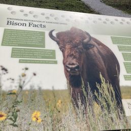
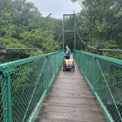
I stumbled upon this place accidentally with my significant other. I was glad we did, because I didn't even think Indiana had a place such as this! I stopped at the Nature Conservancy first and found out there was a Bison Viewing Area very close. That was random for me to find out and exciting all at once! Of course we both wanted to check it out, so I'm glad they had this informational area to learn from before going. They had quite a few information boards posted on the site. I read through all of those to better understand my surroundings and see what it was all about. I'm glad I did, because I learned a lot of cool facts about bison! We walked to the left of the area on the east side to a Trailhead. We reached the end fairly fast. There was a bench that I sat at for a moment and after that there was an Electric Fence! We turned around and went to the other Trailhead in the Bison Viewing Area that was more on the west side. It was another short walk to the end, but this one was where we were able to view the bison from afar. Even though they were far away, it was still calming to see them in their herd. They did have a portable toilet on the site. It was actually clean! Overall, this was more of a self-guided walking adventure. I recommend stopping at the Nature Conservancy before going to the Bison Viewing Area. I was impressed that this place existed and I'm glad that I came! I won't hesitate to return in the future. Date of visit: Apr 20, 2023

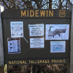
Kankakee Sands is a beautiful large nature area with hiking, plant education, and bison. Subscribing to the Nature Conservancy's Instagram, they posted a video recently of bison being added to the Sands, as a natural prairie management system, as bison roamed this area before! Stop at the park office to pick up some maps and brochures. The office was closed the day we went, but there's a nice outdoor area with maps, and the field manager drove by, gave us directions to the bison, and to a few good hiking spot recommendations. Go directly to See Bison, do not pass go! You can see bison from the side road on the way to the viewing platforms, be careful of semi truck traffic. The bison were roaming, sometimes gently stampeding, and were definitely slightly wary of humans. The "viewing platform" is actually called Bogus Island, which used to be an Island when this whole area was Beaver Lake. (You can read about the draining of Beaver Lake at a nice lenghty placard along the Conrad Station Savanna). Conrad Station Savanna was a great hike through forest and a true Oak Savanna. Thanks to the volunteers and prescribed burns, this is truly a gem of a savanna. The 12-points of interest at Beaver Lake is more of an open prarie hike, as are most of the other hikes. We also stopped by the Nursery because I'm interested in seeds and planting. This is truly a gem of cooperation between the Nature Conservancy, IN DNR and nearby IL DNR and worth a visit.

First time coming here! This place was absolutely magnificent! I've passed by this place often going north and south on US-41 whenever traffic was terrible getting back into illinois but have always wanted to come here since I have always seen Bison here. The viewing area to park at and walk around has a small amount of parking but it has clean, well maintained restrooms trails that are very short and good overlooks. Most of the Bison we saw are all along the outskirts of the preserve from the street. Though you're not allowed to park or stop your vehicle. Park Rangers are always lurking in their trucks somewhere. I was dissapointed in the Elwood location back home in Illinois because I never got to see any Bison but you're guaranteed to see at least 60-80 here! read more


3 months ago
1 year ago
Taking in nature in our own backyard.........It's so peaceful walking around watching these majestic creatures in their natural habitat read more


I stumbled upon this place accidentally with my significant other. I was glad we did, because I didn't even think Indiana had a place such as this! I stopped at the Nature Conservancy first and found out there was a Bison Viewing Area very close. That was random for me to find out and exciting all at once! Of course we both wanted to check it out, so I'm glad they had this informational area to learn from before going. They had quite a few information boards posted on the site. I read through all of those to better understand my surroundings and see what it was all about. I'm glad I did, because I learned a lot of cool facts about bison! We walked to the left of the area on the east side to a Trailhead. We reached the end fairly fast. There was a bench that I sat at for a moment and after that there was an Electric Fence! We turned around and went to the other Trailhead in the Bison Viewing Area that was more on the west side. It was another short walk to the end, but this one was where we were able to view the bison from afar. Even though they were far away, it was still calming to see them in their herd. They did have a portable toilet on the site. It was actually clean! Overall, this was more of a self-guided walking adventure. I recommend stopping at the Nature Conservancy before going to the Bison Viewing Area. I was impressed that this place existed and I'm glad that I came! I won't hesitate to return in the future. Date of visit: Apr 20, 2023 read more

Kankakee Sands is a beautiful large nature area with hiking, plant education, and bison. Subscribing to the Nature Conservancy's Instagram, they posted a video recently of bison being added to the Sands, as a natural prairie management system, as bison roamed this area before! Stop at the park office to pick up some maps and brochures. The office was closed the day we went, but there's a nice outdoor area with maps, and the field manager drove by, gave us directions to the bison, and to a few good hiking spot recommendations. Go directly to See Bison, do not pass go! You can see bison from the side road on the way to the viewing platforms, be careful of semi truck traffic. The bison were roaming, sometimes gently stampeding, and were definitely slightly wary of humans. The "viewing platform" is actually called Bogus Island, which used to be an Island when this whole area was Beaver Lake. (You can read about the draining of Beaver Lake at a nice lenghty placard along the Conrad Station Savanna). Conrad Station Savanna was a great hike through forest and a true Oak Savanna. Thanks to the volunteers and prescribed burns, this is truly a gem of a savanna. The 12-points of interest at Beaver Lake is more of an open prarie hike, as are most of the other hikes. We also stopped by the Nursery because I'm interested in seeds and planting. This is truly a gem of cooperation between the Nature Conservancy, IN DNR and nearby IL DNR and worth a visit. read more


6 years ago
Neat place! The Bison were about 300yds from us, but we expected that and we brought binoculars. The trails are not very long but they're well maintained. We enjoyed our brief time there viewing the Bison! read more

8 years ago
More info about Kankakee Sands Preserve
3294 North US 41
Morocco, IN 47963
Directions
(219) 285-2184
Call Now
Hours
Outdoor Amenities
Ask the Community - Kankakee Sands Preserve


Kankakee Sands Preserve - hiking - Updated July 2026
Best of Morocco
People found Kankakee Sands Preserve by searching for…
Things to Do in Morocco, Indiana
Secret Spots in Morocco, Indiana
Hiking Trails in Morocco, Indiana
Off Road Trails in Morocco, Indiana
Walking Trails in Morocco, Indiana
Playgrounds in Morocco, Indiana
Parks for Kids in Morocco, Indiana
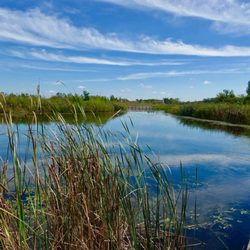
Lakes & Ponds in Morocco, Indiana
Beautiful Views in Morocco, Indiana
River Swimming in Morocco, Indiana
Places to Take Pictures in Morocco, Indiana
Fishing Spots in Morocco, Indiana
Secluded Spots in Morocco, Indiana
Rock Quarry in Morocco, Indiana
Sunrise View in Morocco, Indiana
Photo Spots in Morocco, Indiana
Kite Flying in Morocco, Indiana
Sunset View in Morocco, Indiana
Flower Fields in Morocco, Indiana
View Points in Morocco, Indiana
Browse Brands
Related Searches in Morocco, IN
Best Fishing Locations and Guides in Morocco, Indiana
Best Places for Stunning Views in Morocco, Indiana
Discover Stunning Skyline View Spots in Morocco, Indiana
Discover the Best Running Track in Morocco, Indiana
Enjoy the Best Night View Spots in Morocco, Indiana
Explore Popular Boat Charters Near Morocco, Indiana
Explore Popular Scenic Overlook Points in Morocco, Indiana
Explore the Best Boating Spots in Morocco, Indiana
Find Top-Rated Disc Golf in Morocco, Indiana
Find the Best Scenic View Locations in Morocco, Indiana
Find the Best Swimming Pools in Morocco, Indiana Today
Plan a Scenic Drive Route Near Morocco, Indiana
Popular Places to Take Pictures in Morocco, Indiana
Popular Things to Do in Morocco, Indiana