Jim Reeves Memorial Photos


More like Jim Reeves Memorial
Recommended Reviews - Jim Reeves Memorial
Start your review...


9 months ago
Nice tribute to Mr. Reeves. The area is well maintained and ample amount of parking for visitors. I've passed this for years and finally took the time to stop. read more


3 years ago
It's a beautiful place. Very peaceful. The feeling is live every time I think of my visit. I felt as Jim Reeves is singing at a distance. His deep velvet voice started to echoing. It was very emotional to see Mary and Jim's beloved dog resting in peace along with him. Jim Reeves is a true gentleman and a country music legend. His gospels reminds you of Sunday church. His Christmas songs will always gives you the best Christmas feeling. His love songs will always keep your heart closer to your loved one. Jim Reeves is my childhood favorite singer and will always be one. read more


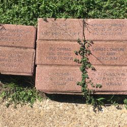
I have to admit I never really knew much about Jim Reeves before stopping here at his memorial, but I do remember hearing his songs most of my life, he had a unique vocal that once you hear him sing you'll never forget it, I was just a small boy when I was first introduced to his music my dad was the fan and I remember a few of Jim's tattered 8-track tapes stacked near my dads tape deck in his shop behind our house, I'm quite sure he still plays them on that old 8-track player still mounted under the counter. While traveling through east Texas I came upon his memorial and just had to stop I'm glad I did and I'm sure I'll remember this day every time I hear his music. Jim Reeves grew up in the small town of Galloway near Carthage before hitting it big as a singer and occasional actor. He is best known for his hits "Make the World Go Away" and "I Can't Stop Loving You." He died in a plane crash in 1964. He also was one hell of a baseball player before a injury turned his focus to music. His impact on the world of music was felt around the world. Inscription: on his memorial- If I, a lowly singer dry one tear or soothe one humble human heart in pain, then my homely verse to God is dear and not one stanza has been sung in vain. read more


7 years ago
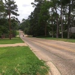
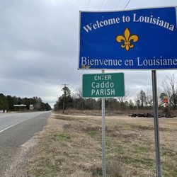
It is as close to the side of the highway as you can get and it is a beautiful, humble garden and memorial that should be on everyone's list traveling down 79. Very underrated, should be in more tourist guides! read more


10 years ago
I unabashedly love Jim Reeves and his tear-inducing tuneage and I'm man enough to admit it! Nobody. Nobody sings like this anymore. Nobody. Not in style, nor in grace. His voice truly is that of an angel's. He mastered just about every Christmas song ever made before his untimely passing in a plane crash in 1964. Musicians and planes, don't know what it is, go together about as well as tornadoes and trailer parks. Leaving behind a void of life unlived and potential never fully realized. My favorite Jim Reeves song is, He'll Have To Go. Listen to it and see if you don't well up and get all misty! If you don't, you ain't got blood in your veins! And If you're ever in East Texas, pay homage to Gentleman Jim, if you will. read more


11 years ago
More info about Jim Reeves Memorial
Jim Reeves Memorial Reviews in Other Languages
Ask the Community - Jim Reeves Memorial


Jim Reeves Memorial - landmarks - Updated May 2026
Best of Carthage
People found Jim Reeves Memorial by searching for…
Things to Do in Carthage, Texas
Sunset View in Carthage, Texas
Places to Take Pictures in Carthage, Texas
Photo Spots in Carthage, Texas
Walking Trails in Carthage, Texas
Hiking Trails in Carthage, Texas
Historical Tours in Carthage, Texas
Watch Sunset in Carthage, Texas
Things to See in Carthage, Texas
Tourist Attractions in Carthage, Texas
Public Services & Government in Carthage, Texas
Historical Sites in Carthage, Texas
Walking at Night in Carthage, Texas
View Points in Carthage, Texas
Scenic Overlook in Carthage, Texas
Trending Searches in Carthage, TX
Boat Rental near Jim Reeves Memorial
Bounce House Rentals near Jim Reeves Memorial
Campgrounds near Jim Reeves Memorial
Floral Designers near Jim Reeves Memorial
Flower Fields near Jim Reeves Memorial
Hiking near Jim Reeves Memorial
Landmarks & Historical Buildings near Jim Reeves Memorial
Nurseries & Gardening near Jim Reeves Memorial
Party Equipment Rentals near Jim Reeves Memorial
Pedicure near Jim Reeves Memorial
Photo Spots near Jim Reeves Memorial
Pool Supplies near Jim Reeves Memorial
Public Services & Government near Jim Reeves Memorial
Browse Articles
Browse Nearby
Browse Brands
Related Searches in Carthage, TX
Best Fishing Locations and Guides in Carthage, Texas
Best Places for Stunning Views in Carthage, Texas
Best Spots for Star Gazing in Carthage, Texas
Best Things to Do on a Rainy Day in Carthage, Texas
Best Waterfalls and Swimming Holes in Carthage, Texas
Discover Charming Historic Homes in Carthage, Texas
Discover Family-Friendly Aquariums in Carthage, Texas
Discover Famous Monuments in Carthage, Texas
Discover Fun Kid Activities in Carthage, Texas
Discover Historic Sites and Places in Carthage, Texas
Discover Popular Landmarks in Carthage, Texas
Discover Popular Photo Spots in Carthage, Texas
Discover Romantic Views in Carthage, Texas
Discover the Best Beaches in Carthage, Texas
Enjoy Hiking Adventures in Carthage, Texas
Enjoy the Best Night View Spots in Carthage, Texas
Explore Beautiful Castles and Landmarks in Carthage, Texas
Explore Beautiful Parks and Green Spaces in Carthage, Texas
Explore Family-Friendly Zoos and Wildlife in Carthage, Texas
Explore Free Kids Activities Near Carthage, Texas
Explore Free Things to Do Around Carthage, Texas
Explore Fun Field Trips in Carthage, Texas
Explore Popular Scenic Overlook Points in Carthage, Texas
Explore Popular View Points Around Carthage, Texas
Explore Scenic Lakes to Visit in Carthage, Texas
Explore Scenic National Park Locations in Carthage, Texas
Explore Sunday Fun Things to Do in Carthage, Texas
Explore Venues & Event Spaces in Carthage, Texas
Explore the Rich History in Carthage, Texas
Find Beautiful Views in Carthage, Texas
Find Top Art Museums in Carthage, Texas
Find Top Libraries to Visit in Carthage, Texas
Find a Public Library Near You in Carthage, Texas
Find the Best Bridge Spots in Carthage, Texas
Fun Indoor Activities to Try in Carthage, Texas
Get Your City Pass for Attractions in Carthage, Texas
Popular Kids Activities in Carthage, Texas
Popular Places to Take Pictures in Carthage, Texas
Popular Things to Do in Carthage, Texas
Public Services & Government Offices in Carthage, Texas
Relax at Natural Hot Springs Near Carthage, Texas
Top Museums for Kids to Visit in Carthage, Texas
Top Places to Visit in Carthage, Texas for Sightseeing
Top Things to Do With Teenagers in Carthage, Texas
Tour Famous Lighthouses Located in Carthage, Texas
Visit Cultural Centers in Carthage, Texas
Visit Popular Museums in Carthage, Texas Now
Visit a Free Museum Near You in Carthage, Texas