Cancel

    Open app

    Search

    Hope Point Trail

    5.0 (2 reviews)

    Hope Point Trail Photos

    You might also consider

    Recommended Reviews - Hope Point Trail

    Your trust is our priority, so businesses can't pay to alter or remove their reviews. Learn more about reviews.
    Yelp app icon
    Browse more easily on the app
    Review Feed Illustration

    4 years ago

    Helpful 7
    Thanks 0
    Love this 5
    Oh no 0
    Photo of Joy L.
    170
    1650
    9598

    4 years ago

    Helpful 5
    Thanks 0
    Love this 4
    Oh no 0

    Verify this business for free

    Get access to customer & competitor insights.

    Verify this business

    Falls Creek Trail

    Falls Creek Trail

    5.0(6 reviews)
    5.0 mi

    Man, how am I just now getting around to hiking this?!…read more Falls Creek is located at ~Mile Post 105.6 on the Seward Highway. In relation to other trails: To the West: Rainbow Trailhead (https://www.yelp.com/biz/rainbow-trailhead-anchorage) To the East: Indian Valley Trailhead (https://www.yelp.com/biz/indian-valley-trail-anchorage) Stats: Mileage: 2.7 (one-way) Gain: 2,900 ft About a 1,000 ft/mile, steep but not *too* steep. The trail starts out...next to a falls! It closely follows Falls Creek for the first half of its length. As the water is loud and the brush is thick, I'd highly recommend doing some trail karaoke with your friends to make sure you alert any bears in the area that you're coming. Eventually, you get out of the brush and the valley expands. It's gorgeous. It's wide and it's bright-freakin'-green (my favorite shade of that color), or at least it was in mid-June. This is going to sound odd but, it actually reminded me of some of the valleys I hiked in Hawaii! It made me a little butthurt that I am only just-now getting around to hiking the trail. The trail ends at a lake. I'm not sure what the name of it is, so I'll just call it "Falls Lake". The lake frequently has snow on/in/around it, up until July. But, there is an ample amount of vegetated, snow-free flat area around the lake, this would be a perfect "Baby's First Backpacking" trip. (no permits required, just load yourself down and hike up) You can continue up past the lake, onto the ridge between South Suicide Peak and Indianhouse Mountain. The path will quickly change from "hiking" to "scrambling" though. I'd only recommend going up South Suicide if you are confident on your feet, and I'd only recommend going up Indianhouse if you have a rope and a partner! If you're quick enough, this can be done as an after-work hike. If you're slow or looking for a casual stroll, you can easily make a day of this hike.

    I'm still sore. Dragged my spouse and our neurodivergent son with me to do this hike on a sunny…read moreSeptember Saturday. We parked at 1pm (parking lot was packed). Got back to the parking lot after 5pm. You'll need most of your day to do this hike if you're not a professional. This hike is beautiful but it is challenging for sure. You are going uphill the entire time. On the way down it's so steep you're jamming your toes trying not to fall. We did the bulk of this hike with nothing but backpacks full of snacks hahaha. Everyone that passed us up or down had poles, guns, bear spray, bells, dogs, the whole enchilada. I don't recommend hiking this area the way we did, we just got lucky :) It was a beautiful day and we were never alone for longer than 15-20min at a time. Weather was perfect, it was sunny and warm but the breeze was breezin'. The falls are a sight to see and made this strenuous hike completely worth it for my water-loving son. I can't wait to return soon and make it further.

    Photos
    Falls Creek Trail
    Falls Creek Trail - Falls Creek 11/16/19

    Falls Creek 11/16/19

    Falls Creek Trail - Nice spot at the end to cool off.

    See all

    Nice spot at the end to cool off.

    Gull Rock Trail - July bear scat, as always we saw quite a bit

    Gull Rock Trail

    4.3(3 reviews)
    0.5 mi

    A word of caution: this trail is BRUTAL in the winter…read more I think it's because the people of Hope rarely hike it then. The final 3 miles were pure misery, non-stop post-holing. It took us nearly 7 hours RT, this shocked my climbing partner and I both. In the summer, I imagine it can comfortably be done in half that time. The trail is mostly flat, and 5 miles, one-way. At the 5 mile mark, there are some places to camp. This would be a great trip for a beginning backpacker. Most of South-central was socked in when we hiked it, so the views at the end were just OK. Already dreaming of a warm, summery, Corona-free hike in the future. Will re-review it then. As it stands now, it's high-effort, low-reward. You'd be better served by a higher elevation, but more frequently used trail in the winter. (like Flattop, Powerline Pass, Rabbit Creek, etc)

    Gull Rock Trail, located in the Chugach National Forest, is a really excellent, moderately easy…read moretrail that has a lot to see and explore. Able bodied adults, children and seniors will enjoy this trail as long as they go prepared for some terrain changes and the misty rain that enevitably descends on hikers in this part of Alaska. To access Gull Rock Trail, take Hope Highway to the end and the entrance and parking lot are on the left. If you are camping at Porcupine Campground, you can access the trail from a 2ndary trail head there as well (which carves .5 miles off the one way distance of the hike.) There is no public parking in the Porcupine Campground to access the trail, so hikers are best off parking at the main trailhead (or camping at Porcupine... make reservations online or you'll NEVER get spot !) Unfortunately I jacked up my knee right before my vacation (argh!) so I was only able to hike about half the trail but it was very enjoyable but not terribly challenging. There's some elevation changes, but not more than about 500 feet elevation gain total. The terrain, however changes a lot. There's rainforest, birch forest, pine forests, talus (rockslidy areas), views of the inlet and the mountains. It's a nice bit of everything. There's some minimal berry picking as well, but nothing particularly exciting. There are some water sources about, so if you bring a water purifier along with you you'll stay well hydrated. There's also, unfortunately ample mosquitos. It's DEFINITELY a trail you want to be prepared for wildlife encounters (bear spray/gun), injuries (first aid pack), and basic survival stuff (a way to purify water, start a fire and a space blanket). Most of the trail has cell service since across the inlet is Seward Highway (which you can see in some spots). But there are dead spots and if you get hurt, no one's gonna find you for a while, so be prepared to hunker down. We had a bear scare on the trail because in some places the brush and shrubbery is flush with the trail. That always makes me a little squirrley. Especially if you take kids with you, be prepared for large animal encounters. There's not a lot of traffic on this trail past mile 2, so it's pretty secluded for some nice quiet time with nature. Enjoy!

    Photos
    Gull Rock Trail
    Gull Rock Trail - Oh boy

    Oh boy

    Gull Rock Trail - Trail map

    See all

    Trail map

    Rainbow Trailhead - looks like Yelp doesn't yet support 360 degree panos...use your imagination

    Rainbow Trailhead

    5.0(1 review)
    5.2 mi

    If you want a trail that's a step up from your usual Flattop, this is a good candidate…read more Stats: Mileage: ~2 miles Gain: ~3,500 ft For comparison, here is flattop: Mileage: 1.5 miles Gain: 1,350 The trail is only slightly longer but packs ~2.5X as much gain! It's located between the McHugh Creek (https://www.yelp.com/biz/mchugh-creek-chugach-state-park-anchorage) and Falls Creek trailheads (https://www.yelp.com/biz/falls-creek-trail-anchorage). It's poorly-signed so you gotta be on the lookout! (mile marker is between 108 and 109). Like just about every trailhead on the Seward Highway, it connects with the moderate and uncreatively-named "Turnagain Arm Trail" (https://www.yelp.com/biz/turnagain-arm-trail-anchorage). The main attraction here is summiting Rainbow Peak. To do this: - From the parking lot, walk West (towards Anchorage) till you find the trail. - This short unnamed trail feeds into the Turnagain Arm trail, you'll quickly come to a sign at the junction with TA trail. You'll want to, again, go towards Anchorage. (e.g. NOT towards "Windy Corner") - Look for where the trail crosses a gravel service road (warning: do not go up this, weird private property section!) Once you cross this, start being on the lookout for a scree covered "trail" to our right. It's very close to where the TA trail crests up on a ridge, it'll be on your right. It'll look sewwwper steep, but, don't be scared (I recommend grabbing trees, in the amateur alpinst world, we call this a "veggie belay"). It lets up. After a while, you'll gain the ridge proper and it'll be pretty obvious where to go (up!) The views from the summit are pretty good, you can see the neighboring trails (McHugh and Falls Creek), the Suicides, and a panoramic view of the arm. A word of caution: be on the lookout for bears and always carry spray and/or hike in groups. I saw a grizzly bear on a neighboring slope (he was far away, he just chilled in the bushes the whole time) and some hikers coming down told me they saw a black bear chasing a sheep on the ridge. I then started hiking with my spray-drawn. I thought I looked like Special Forces team, but I probably more closely resembled The Orkin Man. (is that still a thing? Do people still know who he is?) Definitely, try this one out, it can also be done as an after-work hike if you don't mind coming in a little tired the next day!

    Photos
    Rainbow Trailhead - Summit marker

    Summit marker

    Rainbow Trailhead - Great views of the arm

    Great views of the arm

    Rainbow Trailhead

    See all

    Yuyanq’ Ch’ex - On top!

    Yuyanq’ Ch’ex

    5.0(1 review)
    9.3 mi

    Wow, how lucky are we to have two epic peaks within a 30 minute drive of Anchorage?…read more You have probably seen these guys as you drive around Anchorage. They are set back a bit, so they don't appear to be some of the larger peaks of the Chugach front range. Keyword: appear. These are both around 5,000 ft, which is pretty tall for the Chugach front range. (For comparison, Flattop is 3,510 ft tall) You can access them from the Rabbit Lake trailhead: http://www.yelp.com/biz/rabbit-lake-trail-anchorage?osq=rabbit+lakes The Rabbit Lake trailhead is to the South of the Flattop/Glenn Alps trailhead. Best way to get there is to take De Armoun Rd east (towards the mountains) until you just can't anymore. Anyway, there are various ways to climb these two peaks. I'll describe it from the Rabbit Lake side. But first: WARNING: CLIMBING IS INHERENTLY DANGEROUS, HAVE A PLAN, AND A BACKUP PLAN, AND EXTRA LAYERS AND WATER. If it's well into summer (Mid-June onward) these are both probably a craggy, scree-filled, strenuous hike to the top. If there is a lot of snow, a helmet, ice axe, and crampons may be required. From Rabbit Lake, climb up to the saddle inbetween the two peaks. From here turn left (north) to climb up North Suicide. You can then turn around and do the same thing for South Suicide. As you're coming down South, be on the lookout for scree/snow gulley on your left. This makes the descent a lot easier. I went up in late May during some gorgeous weather, can't wait to get up there in the winter!

    Photos
    Yuyanq’ Ch’ex - On top

    On top

    Yuyanq’ Ch’ex - Climbing up

    Climbing up

    Yuyanq’ Ch’ex - Going up

    See all

    Going up

    Resurrection Pass Trail - Fox Creek Cabin

    Resurrection Pass Trail

    2.0(1 review)
    4.5 mi

    I know, I know, I'm two-staring a hiking trail…read more I'm going to nature-appreciation-hell. So be it. This trail is beloved by many, but I just don't get it. I've only done the first 12 miles of this 38 mile trail and...they were a total bore. The "bang-for-buck" on this one is very low. This would be a great trail in upstate NY or Vermont. For Alaska though? It's a total snooze fest. It seems to get most of its hype because: 1) It's really well-maintained (no bushwhacking). 2) If you plan ahead, you can stay in cabins. 3) There is very little elevation gain It would probably be a fun mountain bike too. (mountain bikes are allowed, not common for most Alaska trails) For a hike or a backpacking trip on foot though? Boring. You're in the trees most of the time. When there's a clearing, you are looking at the types of mountains Alaskans call "hills". They aren't steep, they aren't tall, they're short and gentle. Many are shorter than peaks in the Appalachian mountains of the lower 48. There are no glaciers to see. There isn't much wildlife (I only saw a few birds in 12 miles of hiking). The trail gets really icy in the winter. (definitely bring micro-spikes if hiking in/through then) The cabins (we stayed at Fox Creek Cabin, future review coming up) are not well stocked with wood in the winter. Make sure you bring a few duralogs if you're hiking in in the winter. I'm glad Alaska has a trail like this, and I'm glad it's popular. It'll keep the crowds away from the better hikes :)

    Photos
    Resurrection Pass Trail - It helps to have a charming hiking partner

    It helps to have a charming hiking partner

    Resurrection Pass Trail - It helps to have a charming hiking partner

    It helps to have a charming hiking partner

    Resurrection Pass Trail - It helps to have a charming hiking partner

    See all

    It helps to have a charming hiking partner

    Bird Ridge Trail - Blue hour

    Bird Ridge Trail

    4.3(3 reviews)
    8.7 mi

    Oh my goodness…read more Unlike most people, when I'm super-excited, I don't cuss. I use granny phrases like "Heavens!". I'm so excited about this trail, I can't believe I'm just now hiking it. Bird Ridge starts at a big trailhead with blasted-out rockwalls from when the Seward Highway was widened. It has bathrooms at the parking lot and then another (emergency?) bathroom about 1,000 ft up the trail. After the second bathroom, you start going up! And up! And up! There's a lot of gain here in a short amount of time. If you do it in the winter, micro-spikes (choose your favorite brand) are pretty much mandatory (it gets mighty slippery). I'd also HIGHLY recommend a pole of some sort. An ice axe would even be handy for the upper reaches. I'd also recommend you STAY OFF THE CORNICES, people have DIED. But, if you stay off the corniced ridges, this trail is still decently safe to do in the winter. You're on a ridge which is, by definition, one of the safest places to be in avalanche terrain. You'll get amazing views of Penguin Peak (which I recommend NEVER doing in the winter, it is VERY avalanche-prone) to the east and of Indianhouse South Suicide North Suicide Homicide Avalanche Mountain to the West. To the north, you can keep taking this ridge for miles, although it looks like it gets increasingly gnarly. I can't comment on what it's like in the summer, but I've heard it's beautiful. This is a great place to get above the clouds in the winter. You'll have sun on your face while everyone at lower elevations ferments in the gloom! As a bonus, the trailhead is plowed.

    Drive south on AK1. pass Indian Valley meats on your left, and you will see a sign for "Bird Ridge"…read moretrail parking lot. (Sign will be on your Right, but the parking lot is on your left when you head south on AK1.) $5 for parking or use your park pass. uphill work out with a fantastic view once you climb up over 3000 feet. If you are fit, you can ascend in less than 2 hours to the top. The trail continues behind along the ridge towards girdwood possibly. Also often times you can spot eagle soaring when you look back towards Turnigan Arm/Inlet. Everything becomes so small when you are up at the peak. It's challenge but you will be rewarded with the view.

    Photos
    Bird Ridge Trail - Blue hour

    Blue hour

    Bird Ridge Trail - Blue hour

    Blue hour

    Bird Ridge Trail - Me

    See all

    Me

    Bird Peak - Bird Peak as seen from the summit of "The Wing"

    Bird Peak

    4.0(1 review)
    13.6 mi

    This peak is accessed from the penguin creek trail:…read morehttps://www.yelp.com/biz/penguin-creek-trail-anchorage Depending on who you ask, it may be considered the most difficult hike in Chugach State Park. It definitely requires lots of off-trail travel and navigation, that's for sure! Here's my trip report from when I summitted it: 
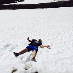
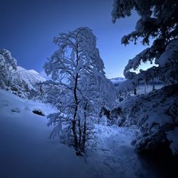
We left the penguin creek trail shortly after and began our traverse into the hanging valley. We ended up maintaining an elevation of roughly 1400 ft before steadily ascending to 2600 ft to drop down into the hanging valley. This decision was...OK. It wasn't a sufferfest, but it wasn't exactly great. There was definitely some bad snow and some alder-wrangling. The lake of any chlorophyll in any of the foilage made route-finding through it much easier...but there was still ample grunting and rubber-banding-gunning of branches. 
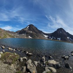
Rather than take the full ridge up Bird, we decided to go up-valley and then gain the ridge near "Point 4800"/"Point 4840" (I've heard it called both things, and on my map it isn't either of these elevations, anyone know where this name is documented?) Anyway, we started ascending form the valley floor at roughly 60.9989, -149.3137. It was mostly snow climbing on snow of marginal quality. Lower down it was very bad wallowing, so we climbed the rock bands. Eventually the rock bands ended and we were climbing a spine of snow (reminded my of the "hogsback" from my Mt Hood climbing days!). It was straightforward ascending, but extremely bad visibility was a little anxiety-inducing. We were in and out of rolling whiteouts and there was so little contrast my camera couldn't auto-focus, ha! We kept taking the obvious gully up, and eventually were dumped out onto a flattish rock band. From there steep, firm snow climbing to gained the ridge proper. (we didn't put our crampons on for this, but we probably should have) We aggressively side-hilled to avoid going up and over Point 48XX, a decision that didn't end up saving any time. Knife-hard Icy snow slopes peppered sloppy scree fields making travel annoying, unless you're really good at crampon-changing! Eventually we were at a low-point in the ridge, where I found a sneaky route down. I was a line I had heard described in some trip reports at the end of the valley that could take you directly to the summit ridge and probably save a lot of time, if it had snow on it. There was a ton of good-looking snow on it, so I noted it in caltopo (60.9981, -149.2958) for a possible, hot-pizza-at-Moose's Tooth-preserving descent short-cut. What we did next is hard to describe, but sticking to the ridge became difficult so we started side-willing east towards the true summit. Eventually we were on and off of really bad choss that was either dusted with half-melted powder or hardened by rime ice (similar to what Kevin Downie experienced last fall: https://www.peakbagger.com/climber/ascent.aspx?aid=1524570) . I can see how this would be a fun scramble in the summer, but dodging icy gullies and scraping choss with crampons was not! Abbey found an "easy" icy ramp to the summit area (I thought it was kinda scary), and after front-pointing on some rime, we reached the snow-and-rime dome that is the Bird Peak summit...to absolutely zero views. Vis was probably at 20-30 ft? There was enough visibility for us to scout an easy snow ramp that would take us down from the summit. (Anything to avoid down-climbing the Abbey M0 variation!) Long story short, the snow ramp was also extremely hard snow. It would've protected beautifully with even vertical pickets. We just kept our heads down and slowly front-pointed down it for what seemed like forever. Eventually we got back down to the scree slopes, took the crampons off, and started side-hilling back to the ridge (west). We went right to the descent line I had marked and...it still looked pretty good. I got out and tested it a little and it was just too hard to tell what the quality of the snow would be once we got out on it. I still had some mild anxiety from the summit downclimb and wasn't interested it going down a long slope with that level of firmness (especially with my crappy ultra light crampons, but that's for another time) We talked about it and, with some hesitancy, decided to go down the way we came up. We didn't side-hill Peak 48XX this time, we stayed pretty high, and travel was much faster! We found where we were topped out on the ridge, put our crampons on, and started down-climbing. The first small section was really steep, but eventually we were quickly plunge stepping down the slopes. I decided to go left (south) down a different way than what we came up to make it a pure snow down-climb. Heavy, wet snow in this area made for perfect wet-cement, slow-and-steady glissade conditions. We then trudged through chunky-water-style snow back to our tent, and we quickly saturated our gaitered mountaineering boots. Good day in the hills? Um, kinda?

    Hope Point Trail - hiking - Updated May 2026

    Loading...
    Loading...
    Loading...