Cancel

Open app

Search

Hidden Dagger Adventures

5.0 (3 reviews)
Closed • 7:00 am - 7:00 pm

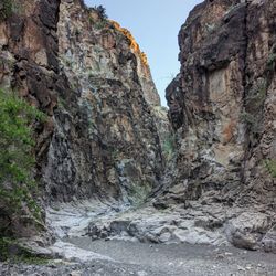
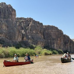
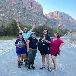
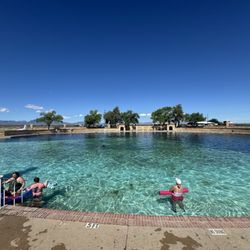
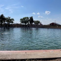
Hidden Dagger Adventures Photos

More like Hidden Dagger Adventures

Recommended Reviews - Hidden Dagger Adventures

Your trust is our priority, so businesses can't pay to alter or remove their reviews. Learn more about reviews.
Yelp app icon
Browse more easily on the app
Review Feed Illustration

2 months ago

Helpful 0
Thanks 0
Love this 0
Oh no 0

3 months ago

Helpful 0
Thanks 0
Love this 0
Oh no 0

1 year ago

Helpful 0
Thanks 0
Love this 0
Oh no 0

Ask the Community - Hidden Dagger Adventures

Hancock Hill - The bikes

Hancock Hill

(5 reviews)

Beautiful place just watch your step. The desk is reached by going up then diagonal right.read more

5-stars for the experience alone!…read more So, there's not a lot of detail on how to find the desk (and, no, it is NOT easy like other might suggest), but because I feel like it was meant to be a right of passage I'm not gonna make it easy either. To get to the trailhead, go the Sul Ross campus Entrance 4 and follow it all the way back to the mountainside dorm. The trail begins there and it isn't overly steep, but you will def get your cardio in on the way up! Head straight for the big pile of rocks at the top. Once up there is where it gets a bit tricky. I will tell you once up there follow the trail to the right. This is where I honestly had no clue on where to proceed and after wandering for a bit (the 20mins is BS FYI, it may take u 10mins to get up there, but unless you know exactly where the desk is, you will be roaming for at least that long!). I oriented myself by looking for the plateau vistas from the various posted pics of the desk. Once I realized what side of the "hill", I needed to be on, I was able to fixate on the one distinctive plateau vista in the pics from the desk and headed that way. Once I came to the bike-tree, the desk is not far beyond that point. I will admit, I had gotten to a point of disorientation where I was going to give up (especially since I had forgotten my water bottle in the car...so be sure to bring water as it is brutal between the sun & wind on the hill), but #nevergiveup It really was the absolute best feeling when I finally found the desk! It was like finally finding a lost treasure after digging in so many wrong places. Definitely worth doing if you are in the Alpine/Marfa area!

Davis Mountains State Park - Overlook at sunset

Davis Mountains State Park

(62 reviews)

Davis Mountains State Park is a park that I've always wanted to come back to and I finally did…read moreafter 8 years. As one of two Texas state parks that provides mountain trail access, this place can offer some phenomenal views of nearby mountains both near and far. I came here for a two-night camp. I made all my reservations online and arrived before the office closed to check in. The campsite I reserved had both water and electric hookups, which I did occasionally use during my time here. There are many hiking trails to choose from, although some trail access was restricted due to recent flooding. But all the trails I hiked were well-maintained and clearly marked. My favorite trail, Skyline Drive Trail, took me up the side of the mountain via switchbacks up to the mountain ridge. The trail leads all the way to the famed CCC overlook that allowed me to see differently-shaped mountains in the distance. I thought it was cool that I could see the University of Texas McDonald's Observatory from the overlook, even though it requires a 13-mile drive to get there from the park. During my stay, I also had the opportunity to attend a ranger talk. The ranger came from the nearby Fort Davis National Historical Park with some relics of times past. The talk was informative and entertaining. I enjoyed the clean bathrooms near the campsite, though you'll have to bring your own shampoo and body soap to shower. The water provided at the campsite is potable and I thought it tasted better than the tap water I get at home! I thoroughly enjoyed my time here and would love a chance to come back in the future!

Stumbled upon this stunning state park during a short stay in Fort Davis. We did a scenic drive on…read morethe Skyline Trail, and did some short hikes to enjoy the absolutely stunning vistas o west Texas from various viewpoints. We also briefly visited the recently renovated Indian Lodge (open for breakfast and lunch), which we hope to stay at next time. This state park is a hidden gem and absolutely worth a visit!

Balmorhea State Park - Comfortable seating

Balmorhea State Park

(87 reviews)

Out on the frontier removed from the frustrations of civilization sits Balmorhea an artesian gem…read morehiding among the tumbleweeds. The springs themselves are astonishing. Crystalline water, a natural oasis. Wilderness as a touch of elegance. The water is cool, refreshing, and large enough you can swim without bumping into a flotilla of inflatable flamingos every ten seconds. It is serene. Now, the true pièce de résistance: tiny fish. Yes darling, little cousins of piranhas nibbling delicately at your skin. At first, it's mildly horrifying. Being lightly snacked upon by aquatic creatures isn't typically on the itinerary. It's nature's exfoliation service. Truly. These miniature aestheticians gather around and provide the most delightful, ticklish skin treatment imaginable. Think of it as a rustic version of spa fish pedicures, except this one is completely natural, wildly entertaining, and performed by creatures that actually live in the ecosystem instead of a questionable salon tank. The entire place has this fascinating ecological charm that sneaks up on you. You're floating in a massive spring-fed pool, mountains in the distance, dragonflies skimming the water, and tiny fish politely tend to your skincare needs. The magic of Balmorhea (I'll let you figure out how to pronounce it correctly) is that it's a living ecosystem, and being able to swim in the middle of it is special. It's frontier chic. Don't expect marble spas and cucumber water. Following an afternoon, my skin felt absurdly smooth, stress level plummeted, and it was imperative to recommend the remote desert destination without qualification. Five stars for the fish running the spa.

Fun time at this park…read more Enroute from San Antonio to El Paso, we were able to stop at this park to get the kids out of the car and into some refreshing spring water It was clean, not crowded and left us already planning a return on our next trip back or towards Big Bend National. There are cabins on the ground, picnic tables, barbecue pits. I saw a basketball court. They had a few nature areas to enjoy. I was certainly pleased with just getting my feet wet, but the water is clear and if you were interested in seeing more below the water, I recommend goggles or snorkeling gear. I hear companies teach scuba here too. There's not much else near the park, so bring all the amenities you need or want there. Good times with nature. We will return.

Emory Peak - Instagram: @telephonesmoothie

Emory Peak

(7 reviews)

The hike to Emory peak is iconic and stunning. You get an amazing view of the window along the…read moretrail, and from the top you can see all the way out to the south rim - it's like you really can see forever. The hike is fairly moderate up until you get to the scramble at the very end, which really does require using your whole body - arms and legs. The climb up really isn't all that bad, but coming down was a little bit tricky, even if just because it's easy to forget the path down and there's only one or two feasible options for a normal sized human. That said - I would recommend making the climb to the very top. It's a narrow area, just a few boulders wide - I'd guess that 15 people or fewer can actually fit up there at one time, and that would be standing close to one another. Overall: if you're going to do one long hike in big bend, I would say this should be it. You can do the whole thing round trip within 4ish hours if you walk fast, or take your time and spend longer. But seriously, you cannot beat the views.

Good hike. A bit strenuous, but worth it…read more But, if I had to choose between the South Rim, and Emory Peak, I would go for the South Rim. It's longer, not quite as strenuous, and more scenically diverse. Seeing the Rio Grand, from the South Rim, was amazing, but this is the Emory Peak page. If the South Rim had it's own Yelp page, I would go 5 stars! Once you get to the top, you are rewarded with a pretty good view, and cell phone coverage. At least we had it on two different networks. So get that selfies stick out, and watch your step. If you are aggressive, fast, and start early, you could probably do Emory and South Rim in the same day. Heading to the South Rim takes you to the path for Emory Peak, but it will add several hours. We did not start terribly early, so we just did a quick out and back, from the Chisos Basin Campground ( https://www.yelp.com/biz/chisos-basin-campground-big-bend-national-park ), which is where we were camping. Bottom line: If your pressed for time, I would skip it. Since we did South Rim, I would rather have seen more of the park, but hiking to the tallest spot in the park was pretty cool! PS. Review is a bit late. We were in early March, 2018.

Big Bend National Park - Big Bend Welcoming

Big Bend National Park

(155 reviews)

My husband and I made a trip out to Big Bend National Park before the Texas summer heat.....but it…read morewas unfortunately unseasonably hot this year. The dessert was beautiful and the park as a whole was very well taken care of! Old Mine Trail: Since we went around "Spring Break", the parking lot was very busy and spaces were limited. I would recommend downloading the "All Trails" app to gauge how busy the trails are. By 7:30, all the spots in the small parking lot were already taken. The trail itself was very well managed. Although the parking lot was busy, the trail was not bad! We were pretty spaced out between hikers! Take lots of water and snacks! The views up top are spectacular. Star Gazing: We were at Sotol Vista (for panoramic stars). The stars were especially beautiful inside the park because there was no light pollution (aside from the headlights from passing cars down below us).

I once hiked to the bottom of the Grand Canyon and spent a few nights camping down there. While…read moredown there, an elderly man easily every bit of 70 years old asked me if it was my 1st time down at the bottom. I told him that it was and asked him if it was his 1st time. He chuckled and said, "No this is my Sanctuary". After my 3rd visit to Big Bend in 12 years, I think Big Bend may be my sanctuary. Big Bend is in the middle of nowhere. You do not just stumble upon Big Bend; it is a planned destination. You won't find a Gatlinburg like town next to it or an exit sign off the interstate saying 8 miles from here. It's miles from anything. The type of place you don't pass a gas station, and you carry a case of water in the vehicle. We have hiked various trails before and canoed Santa Elena Canyon, but I will focus on the trails we hiked this visit. Note: I have only done day hiking here, so no Insite in this review about backpacking although I would love to at some point. We started off at the visitor's center at Panther Junction as everyone should do in my opinion. Rangers can give you up to the minute updates like telling us the Hot Springs road was still closed because of a flood this past July (2025). She said we could still hike it but it would add an additional 4 miles (2 each way) to our trip. Good Insite. Our 1st hike was a short one in Boquillas Canyon. It was a short 1.4-mile round trip up a small cliff and back down to the Rio Grande river. It was an extremely easy hike that anyone who can walk can do. we then did a forementioned Hot Springs hike. This is a very cool spot with old, abandoned buildings from a time when the area was a resort. There is still a hot spring alongside the river that had people soaking as we walked past. The only downfall of the area was it still hadn't been repaired since the flood, so picnic tables were under sand, and I don't want to tell you what the bathroom looked like. The next day we did the Window Trail and it's a 5.6 miles hike right in the middle of the Chisos Basin. This one was I guess I would call moderate, but I am also an overweight old fart. It's really not bad except if it's hot out because you will be in the direct sun and the small number of switchbacks on your return trip. Other than that, the views are gorgeous. Just don't slide off the rocks at the "window", it's a long way down. The last hike we did was the Grapevine Hill's Trail aka The Balanced Rock. This one is a little more challenging to get to as you have to drive miles down a dirt road that is a little rocky. You don't need a 4-wheel drive, just don't be a speed demon. The hike itself is short, 2.2 miles each way and 95 percent of it is easy. The last little bit is a rock scramble up to see the balanced rock. It is worth it. Amazing views. We had the whole area to ourselves for most of the hike but saw lots of people on the way back so go early. Big Bend is amazing but requires some planning. Don't wing it. Bring lots of water and be smart. Cell service is limited but a lot better than 13 years ago.

Davis Mountains Preserve - Davis Mountains Preserve 2.15.2025

Davis Mountains Preserve

(5 reviews)

Davis Mountains Preserve - which is separate from the Davis Mountains State Park - is home to…read moreMadera Canyon Trail. While searching for an appropriate hike for my crew, I came across the the 32,844-acre Preserve established by The Nature Conservancy (TNC). This trail unlike others within the preserve is open to the public. No permit required. The beautiful, slightly moderate 2.4-mile trail is also open all year long, from sunrise to sunset, regardless of the closure of the Davis Mountains Preserve. My young daughters, my Black Mouth Cur, and I are now fans. We hiked the entire loop on 2.15.2025. A sign-in sheet was at the large kiosk at the entrance. There was a somewhat snobby couple that came in after us that neglected to sign in. But I digress... Yes, contrary to Shannon B.'s review from Apr 2, 2018, leashed dogs have always been and still are welcome... there is a dog waste bag station near the trail's entrance. Remember to leave no trace - only footprints. Best part of all of this beautiful nature? Free parking & entry. Thank you, TNC and DMP. What a Lonestar State gem. Here's more info: https://www.nature.org/en-us/get-involved/how-to-help/places-we-protect/davis-mountains-preserve/

The Davis Mountains Preserve is a privately-held 33,000-acre treasure managed by the Nature…read moreConservancy approximately 25 miles northwest of Ft. Davis on Hwy. 118 (about 10 miles past McDonald Observatory and about ¼ mile past the Lawrence E. Wood Picnic Area; 30.70723, -104.09968) in Jeff Davis County in the northeastern Chihuahuan Desert. No, this isn't the state park with a similar name, but a wholly different destination that you should add to any Fort Davis, Texas itinerary if you love the outdoors. The Conservancy established the Davis Mountains Preserve in 1997 from the lands of the historic U Up U Down Ranch, with the heart of the preserve being the evergreen-covered, 8,378-foot Mount Livermore, the highest peak of the Davis Mountains and the 5th highest in Texas. They describe the place as "a unique sky island with plants and animals found nowhere else in the world." It took until 2004 to acquire the total acreage and the Conservancy continues its vital efforts today to restore and protect this sensitive region through innovative partnerships with ranchers and other landowners, as well as service & educational groups like the Boy Scouts and the Texas A&M Forestry Service. These later agreements with owners of the surrounding lands have created an additional 70,000-acre buffer zone around the preserve. The majority of this nature preserve is closed to the general public, but we can get a taste of what's inside by hiking the 2.5-mile loop known as the Madera Canyon Trail (map: https://www.nature.org/ourinitiatives/regions/northamerica/unitedstates/texas/multimedia/madera-canyon-trail-map.pdf; information about what you'll see: https://www.nature.org/ourinitiatives/regions/northamerica/unitedstates/texas/multimedia/madera-canyon-trail-fact-sheet.pdf). The trailhead is adjacent to the Lawrence E. Wood Picnic Area just off Hwy. 118, and the trail is open to the public year-round from dawn until dusk. Hikers should sign in at the trailhead kiosk prior to departing upon the trail. Be sure to bring plenty of water, stay on the trail, take only photos, and leave only footprints. At a small number of annual special "Open Days" events (generally bi-monthly, around 7 per year), the public is invited inside the preserve for a more intimate look throughout the entire property: hiking, biking, camping, horseback riding, picnics, photography, birding, stargazing and other outdoor activities. You can check the calendar for those 2018 dates and start planning your trip here: https://www.nature.org/ourinitiatives/regions/northamerica/unitedstates/texas/events/davis-mountains-2018-open-days.xml Know before you go to the special Open Days: * Only high clearance street legal vehicles will be allowed past the McIvor Conservation Center. * Only camp stoves are allowed, and ground fires are prohibited. * Restrooms are available at the McIvor Center. * Guests should bring their own food and drinks, and take their trash home with them. * Hikers should bring their own binoculars, cameras, sunscreen, hats, appropriate footwear and plenty of water to drink. * Firearms and any technology that disrupts quiet enjoyment are not permitted. * For safety reasons, children must be supervised by parents or other designated adults. * No pets are permitted on the Preserve, other than service animals for assistance. More about the Davis Mountains Preserve and scenic drives in the area: http://www.davis-mountains.com/pages/Davis%20Mountains/nc.html https://tshaonline.org/handbook/online/articles/rjd03 https://tpwmagazine.com/archive/2017/jan/ed_3_ponderosa/index.phtml http://www.texashighways.com/travel/item/257-postcards-davis-mountains-scenic-loop

Hidden Dagger Adventures - rafting - Updated May 2026

Loading...
Loading...
Loading...