Hickison Petroglyph Recreation Area Photos


More like Hickison Petroglyph Recreation Area
Recommended Reviews - Hickison Petroglyph Recreation Area
Start your review...

Reviews With Photos

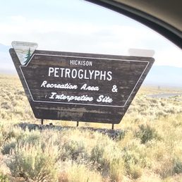
We saw a sign for this when we were driving on the Loneliest Road in America, on our way to Lake Tahoe. We pulled in to see what it was all about. There was a self-guided interpretive trail that took us past some petroglyphs, as well as some other spots. It was a well- marked trail, easy to walk, with numbered markers at points of interest. Our biggest disappointment was that there were no booklets available that explained each marker. It would've been much more interesting if we'd known what we were looking at. If cell service works out there, it'd be nice to have a QR code to scan and get the booklet on our phones if no paper ones are around. It was still a beautiful walk and a great way to stretch our legs on a long driving day. It looks like maybe they have a campground, too, although we didn't take the time to check that out.

Gayle and I stopped here last week as part of our driven on the "Loneliest Road in America" or US 50. The Hickison Petroglyph Recreation Area provides public access to petroglyphs created by prehistoric people living who once lived in this area. Gayle and I enjoyed our detour, which included a short loop featuring several rock formations with various petroglyph features. We both really enjoyed the exercise and scenery, but we both admitted that actually finding these glyphs or perhaps distinguishing them from tourist graffiti was challenging at times. And after touring similar areas of New Mexico and recently in Maui, I found that part of the experience to be somewhat underwhelming. But please come here and see for yourself.

When driving Highway 50, known as the loneliest road in America, you can't help but look for any opportunity to take a break. The Hickison Petroglyph Recreation Area, about 20 miles east of Austin, provides primitive camping and a hiking trail that leads you to petroglyphs, some over 10,000 years old. The short hiking trail and petroglyphs can be appreciated in an hour. Add a packed lunch to the break and you'll be reenergized for the road.

Make sure you bring water and toilet paper. There are no running water hoses out here and bathrooms a more like outhouses with a hole in the ground. If you happen to come here at an off time you might need to provide your own teepee. Put on very good walking shoes as the trail is all loose gravel and there will be climbing involved. It is about .6 miles or roughly can be walked in 30 min. There are several off trails and alternative roundabouts which is great for you to explore. Bring your water with you and your camera. Let's begin. Before going on the search for the petroglyphs, stop by the small metal box on a stand and sign the guest list. Turn around and facing the notice board there is another metal box with a brochure and map inside. When you are done with the map, recycle, which means return the map back to the metal box in the same condition you got it so the next visitor can enjoy the park as well. If you read the map correctly then the trail is to the right of the notice board. If you completely failed to read then you must have either started at the big rock which is the end of the trail or wandered into the adjoining campground and trailhead that have nothing to do with the petroglyphs. As you follow the map there are markers on the ground that coincide with the number on the brochure. If you plan to walk off trail make sure you use the already made trails by previous visitors instead of making new trails. If you make your own trail you might unknowingly trample over natural plants and destroy the rock lined trail that have been so meticulously laid out for you as a guide. If you do decide to venture off trail be prepared to get dirty. I would only encourage the experienced hiker and not all off trails are kid friendly and may be a challenge. The first off trail is off of marker 6 to the right, which takes you up atop of several rocks. Be careful as the rocks are loose and may fall. Use caution and better judgement. This is a great lookout point if you are in search of the sunset. The second off trail is near marker 7 or 8. If you find yourself walking up rock steps go to the top and look to your right. There is a trail already carved out and will take you closer to the ridges that oversee the parking area. This site gives the best view of both the east and west side. Great for waiting for the sunset but bring your flashlight as you will need it when you climb down. Again loose gravel and may require you to climb with your hands in some areas. From this marker if you are heading back to the main trail, make sure you completely follow the trail back down from the rock steps and go left. If you decide to take a "short cut" down the hill you will definitely trample natural plants the park is working to preserve. At marker 9 as you round the turn keep your eyes out as there are lizards that hang out in the shade here. Screaming and jumping around does nothing to get the lizards attention and will only aggravate other visitors so keep your excitement at a reasonable volume. If you reached the big rock that is kept fenced up then you have made it to the end. Dust of your shoes and clothes, return the brochure to the metal box, grab a quick bite and rehydrate before you head back onto the road. A great hike for all skill levels. Great for kids. If you stay on the mapped out trail the walk is between easy and moderate in difficulty. Great picture taking opportunities. Great sunset viewing. Have a safe journey.


This is a nice stop, especially if you're a history buff. We spent about 40 minutes here walking the trail and looking at some of the petroglyphs. Most of the trail is marked and they even have trail maps available for you to grab at the trailhead with a little information on what you'll be seeing. In addition to the petroglyphs, they also showcase some local and historical plants, which I found very interesting. It's free and dog friendly. Although we didn't camp her personally, we did check out the campsite on our way out. It was almost full and each site looked well maintained and well equipped. I especially liked the curved coverings over the picnic tables. If we are ever in the area again, I would definitely give their campsite a try. read more


1 year ago
1 year ago
I stayed one Sunday night in the campground, first stop on my way to Utah, easy to get a FCFS site even though it was probably after 6 PM, very quiet (about a mile off of Highway 50), sites far apart, free!, lots of privacy & shade due to trees and a shade structure over the table. Nice walk to see petroglyphs in the morning. No water. read more
We saw a sign for this when we were driving on the Loneliest Road in America, on our way to Lake Tahoe. We pulled in to see what it was all about. There was a self-guided interpretive trail that took us past some petroglyphs, as well as some other spots. It was a well- marked trail, easy to walk, with numbered markers at points of interest. Our biggest disappointment was that there were no booklets available that explained each marker. It would've been much more interesting if we'd known what we were looking at. If cell service works out there, it'd be nice to have a QR code to scan and get the booklet on our phones if no paper ones are around. It was still a beautiful walk and a great way to stretch our legs on a long driving day. It looks like maybe they have a campground, too, although we didn't take the time to check that out. read more
Gayle and I stopped here last week as part of our driven on the "Loneliest Road in America" or US 50. The Hickison Petroglyph Recreation Area provides public access to petroglyphs created by prehistoric people living who once lived in this area. Gayle and I enjoyed our detour, which included a short loop featuring several rock formations with various petroglyph features. We both really enjoyed the exercise and scenery, but we both admitted that actually finding these glyphs or perhaps distinguishing them from tourist graffiti was challenging at times. And after touring similar areas of New Mexico and recently in Maui, I found that part of the experience to be somewhat underwhelming. But please come here and see for yourself. read more


When driving Highway 50, known as the loneliest road in America, you can't help but look for any opportunity to take a break. The Hickison Petroglyph Recreation Area, about 20 miles east of Austin, provides primitive camping and a hiking trail that leads you to petroglyphs, some over 10,000 years old. The short hiking trail and petroglyphs can be appreciated in an hour. Add a packed lunch to the break and you'll be reenergized for the road. read more


11 years ago
Make sure you bring water and toilet paper. There are no running water hoses out here and bathrooms a more like outhouses with a hole in the ground. If you happen to come here at an off time you might need to provide your own teepee. Put on very good walking shoes as the trail is all loose gravel and there will be climbing involved. It is about .6 miles or roughly can be walked in 30 min. There are several off trails and alternative roundabouts which is great for you to explore. Bring your water with you and your camera. Let's begin. Before going on the search for the petroglyphs, stop by the small metal box on a stand and sign the guest list. Turn around and facing the notice board there is another metal box with a brochure and map inside. When you are done with the map, recycle, which means return the map back to the metal box in the same condition you got it so the next visitor can enjoy the park as well. If you read the map correctly then the trail is to the right of the notice board. If you completely failed to read then you must have either started at the big rock which is the end of the trail or wandered into the adjoining campground and trailhead that have nothing to do with the petroglyphs. As you follow the map there are markers on the ground that coincide with the number on the brochure. If you plan to walk off trail make sure you use the already made trails by previous visitors instead of making new trails. If you make your own trail you might unknowingly trample over natural plants and destroy the rock lined trail that have been so meticulously laid out for you as a guide. If you do decide to venture off trail be prepared to get dirty. I would only encourage the experienced hiker and not all off trails are kid friendly and may be a challenge. The first off trail is off of marker 6 to the right, which takes you up atop of several rocks. Be careful as the rocks are loose and may fall. Use caution and better judgement. This is a great lookout point if you are in search of the sunset. The second off trail is near marker 7 or 8. If you find yourself walking up rock steps go to the top and look to your right. There is a trail already carved out and will take you closer to the ridges that oversee the parking area. This site gives the best view of both the east and west side. Great for waiting for the sunset but bring your flashlight as you will need it when you climb down. Again loose gravel and may require you to climb with your hands in some areas. From this marker if you are heading back to the main trail, make sure you completely follow the trail back down from the rock steps and go left. If you decide to take a "short cut" down the hill you will definitely trample natural plants the park is working to preserve. At marker 9 as you round the turn keep your eyes out as there are lizards that hang out in the shade here. Screaming and jumping around does nothing to get the lizards attention and will only aggravate other visitors so keep your excitement at a reasonable volume. If you reached the big rock that is kept fenced up then you have made it to the end. Dust of your shoes and clothes, return the brochure to the metal box, grab a quick bite and rehydrate before you head back onto the road. A great hike for all skill levels. Great for kids. If you stay on the mapped out trail the walk is between easy and moderate in difficulty. Great picture taking opportunities. Great sunset viewing. Have a safe journey. read more

15 years ago

9 years ago
9 years ago
We stayed here 4-9-17. When we pulled in there was 1 vehicle parked at trail head and the camping area was empty. This is such a beautiful place, well off the highway. We had no need to use the restrooms, so I can't comment on them other than they are typical vault toilets. The garbage cans were empty and all the sites were clean. As stated by other reviewers, there is no water so be sure to bring plenty for washing and drinking. In the Campground Details it says '55 ft max RV length'. Well, maybe a couple sites, but definitely bring a lot of leveling blocks. Most of the sites don't have level parking spots. And that is if your rig can make it through some of the corners. We have a 26' travel trailer and a full size truck. Our trailer is spring over, so it is tall. We slightly scraped an overhanging limb on one side, but with careful maneuvering we were able to choose an amazing site. The sites on the outer edge, with fewer trees, have some shelters over the picnic tables. The hike is easy, with amazing views! Unfortunately the petroglyphs have been quite vandalized, though the trails through the rock formations are still great to look at. read more


11 years ago
More info about Hickison Petroglyph Recreation Area
US Hwy 50
Austin, NV 89310
Directions
Hours
Outdoor Amenities
Other Amenities
Ask the Community - Hickison Petroglyph Recreation Area
Review Highlights - Hickison Petroglyph Recreation Area


Hickison Petroglyph Recreation Area - hiking - Updated July 2026
Best of Austin
People found Hickison Petroglyph Recreation Area by searching for…
Browse Brands
Related Cost Guides
Related Searches in Austin, NV
Best Places for Stunning Views in Austin, Nevada
Browse Top Hotels in Austin, Nevada for Your Stay
Enjoy Camping Adventures Around Austin, Nevada
Enjoy a Relaxing Bed & Breakfast Experience in Austin, Nevada
Explore Hotels & Travel Options in Austin, Nevada
Popular Things to Do in Austin, Nevada
Popular Things to See in Austin, Nevada