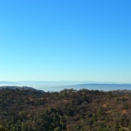
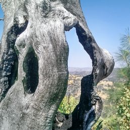
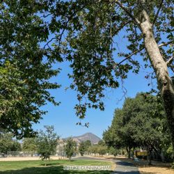
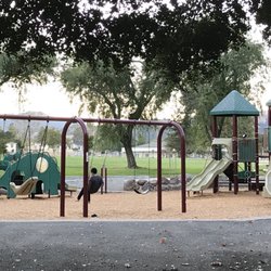
Henry W Coe State Park Photos


You might also consider
More like Henry W Coe State Park
Recommended Reviews - Henry W Coe State Park
Start your review...


1 month ago
Henry Coe has been in my "to hike" list for quite a while. It's the largest in the State Parks system and while, technically, in the South Bay, requires a long, windy drive once you're off the 101. It can seem overwhelming to pick a day hike, given the vastness of the park, so I'd recommend coepark.net. That site lists several day hikes and shares route maps. It was a huge help to me, when deciding to hike the trail to Frog Lake. Henry Coe is popular for backpacking but moderate day hikes can be found and the loop to Frog Lake and back was a wonderland of green hills, tiny wildflowers and vast views of the Diablo Range. It's more about the journey than the destination and I enjoyed hiking through various eco systems that included marsh-like trails, rolling green hills, woodland and a small lake. Parking is self-paid or via the CA State Parks pass. There's a nice visitor center with rangers helping to acclimate you to the park, along with flush toilets and a small gift shop. You feel like you're in the foothills, while really, just a 30 minute drive from Morgan Hill. Now that I've acclimated a bit to the park and its hikes, I'm finally going to add Henry Coe to my State Parks rotation read more


Wonderful start park with various options for different levels of outdoor enthusiasts. If you are looking to camp and hike, you can make a reservation for either the camping site or the backpacking site. For the camping site, all you need to is drive up to your reserved camping spot, and start unpacking, then you have access to water, bathrooms and many hiking trails. The backpacking site will require to hike in and then set up all your gear. Be sure to do your research so that you're not stuck out there without water. This state park affords to the visitor extremely beautiful sunsets and sunrises at the campsite and nearby viewpoints. Astronomy hobbyists will also enjoy the evening scenery, where many astronomical phenomena are visible. As a precaution avoid the yellow grass as ticks do make these areas their habitat! read more


What a hidden gem! I came here for a May backpacking trip and was floored by this park's vast beauty. This park is huge! And not nearly as crowded as other bay area trails. The wildflowers in late-May were incredible! I hiked to Wilson Peak, where the views were amazing. The trails are steep and there aren't many water sources, so be prepared! FYI, port-a-johns are the only restroom at the Hunting Hollow park entrance. read more


Henry Coe State park is the largest Cal State Park, it is huge, 87,000 acres. Much of the land is restricted to foot access so distance is limited. However, one weekend per year in the Spring, Henry Coe opens their Bell Station South gate entrance along Highway 152 to allow registered people to visit the East side of this big park. The event is called Coe Backcountry Weekend, sponsored by the Pine Ridge Association. It's great to be able to travel close to home to camp in such vast wilderness. Here are my highlights from this weekend. Fishing and caught plenty of Bass at Mississippi and Kingbird pond. Saw super blooms of wildflowers due to abundance and a long raining season. Drove off road in our little legendary Suzuki Samurai. I was in 1st and 2nd gear the whole time while in the park. Camped next to Pacheco Creek, lulled to sleep at night frog songs. The big downside was the mosquitoes at dusk. read more


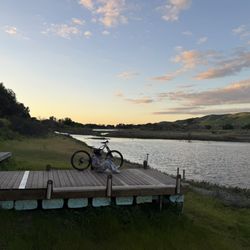
We hiked Sat 2/27/21 Hunting Hollow entrance. Parking fee $6, $5 for senior 62+, self pay. Bring exact cash for the envelope. Parking in large dirt parking lot, 3 pit toilets available. We hiked to Willson Peak, 2651 ft, strenuous hike, lots of Steep hills. Then we continued to Willson Camp and looked for Springs. Springs are mostly in Rubbermade tubs but that's ok. There's a cool Windmill and springs by it, the windmill works with strong winds. I even made a video. Worth going at least once. We hiked 10.5 miles, took all day. Can be lots of mountain bikers here. No dogs allowed. read more


3 years ago
This State park has 87,000 acres with hundreds of miles of fire roads and trails to explore. The park is vast, rustic, rugged and usually steep. Hardy souls will enjoy getting away from it all, and hiking or mountain biking here. There are over 150 (possible) water sources and springs inside this park ( see https://coepark.net/map/water.php ). It can get over 100 degrees in the summer. The highest I have seen on the weather stations ( https://coepark.net/ws ) was 115 or so. The best time to visit is anytime other than the summer months. For more information about the park see https://coepark.net read more


 - Parks Near Me - Morgan Hill, California")


Henry Coe is one of my favorite California State Parks! It is so vast and I love how remote it feels. There are great views to be seen everywhere. Parking is $8 and you pay at the Park Headquarters building after you park. The park rangers were very helpful in determining what trails we should try out based on our skill level and mileage we were looking to complete. There are lots of trails to explore from easy to more strenuous. My boyfriend and I did a lovely 5 mile loop here starting from the Corral Trail, to Flat Frog Trail, up to the Little Fork Coyote Creek. To get back to park headquarters, we took Hobb's Road all the way back. The Hobb's Road is no joke. At least a mile of the trail is a steep uphill trek. It was defiantly an awesome workout!! Next time, we will get all the way up to Frog Lake. If you come from the Bay Area, you would get off at Dunne Ave on 101 and then drive around 10 miles of windy narrow roads. There is a small section that is one way only where you have to stop and let other cars go in the other direction first. That part almost reminded me of the Road to Hana on Maui lol. This is probably one of the reasons that there isn't a lot of foot traffic through the park because it is quite the drive to get up there. I would also bring bug spray with you. The bugs at Henry Coe defiantly love to bother people! And be sure to bring tons of water as Henry Coe is really hot and dry in the spring and summer months. I cannot wait to come back and explore more! read more


9 years ago
Henry Coe State Park - a huge state park with dozens of trails to explore. I enter through the main park entrance/visitor center off E. Dunne Avenue in Morgan Hill. Parking is $8, although there are some spots you can park at outside the entrance too. Previously, I've hiked to Frog Lake, which was a easy, relatively short hike. Today, I attempted to hike down to China Hole (at the suggestion of the park ranger) - a refreshing swim hole sounded tantalizing in this heat. The total distance (round trip) was 10 miles, starting from the visitor's center. The way down wasn't bad, but unfortunately, when we followed the trail, we didn't see a swim hole, just a small creek and a trail with an almost straight vertical incline. So we turned around and followed the trail we came from. WARNING: Henry Coe is super hot in the summer. Heat exhaustion and dehydration will definitely happen if you don't come prepared. Alas, my friend and I were not. She didn't bring enough water and the heat almost defeated her. We attempted to ask a group of boy scouts to give us a lift back to the visitor center (2ish miles) but they declined but gave us water instead. The rangers couldn't pick us up either since they were on the other side of the park, 1.5 hours away. We slowly trudged our way back towards the visitor's center and we somehow made it. I was mostly relieved my friend didn't pass out and I'd have to drag her carcass back. The views of the valley were really nice and there was a variety of terrain, from wooded/shady trails to flat, dry ones. Not many people visit Henry Coe so it'll never be crowded and I find it rare to cross paths with another hiker since the park is so vast. All in all, if you're hiking Henry Coe in the summer, make sure you bring LOTS OF WATER. SO MUCH WATER. ALL THE WATER. You'll need it. Happy exploring friends. read more


11 years ago
Oh, I just love it when I'm the only camper at a State Park Campground!!! I had the ENTIRE campground to myself!! How awesome is THAT???!!! I liked the fact that the cellphone tower was so close by: Having the cellphone tower close by allowed using my cellphone with FULL BARS; unlike other campgrounds I have visited, I would be privileged obtaining one bar~HAH! The drawbacks about camping at this State Park are the following: Driving over ten miles on a windy road: The sheer remoteness left me awestruck photographing panoramic views. Dusty, bone-dry campsites Little to virtually NO shade No privacy No showers Overall, in order enjoying camping here for a couple of days, please make sure you bring a solar shower and shower tent; solar power battery pack and solar panels; 10 x 10 canopy, screen tent. FYI: Bring your H2O filter because I don't know if the ground H2O is clean or not. read more


5 years ago
I really enjoyed this park and the beautiful nature setting. You can choose to do a short trail or a long distance trail. There are a couple of benches to sit and have a snack on. read more


This was one of the most challenging and "cold" hike that I've done in San Jose area. Drove through the Gilroy outlet (girls, fight the urge to go shopping at this point. Close your eyes and step on the gas!), left on New Ave. and right on Roop Rd. and just keep going... you'll come across to a large parking lot for Hunting Hollow on the right. My fiance and I weren't sure which trail we were taking that morning, but as we start walking I saw a sign for "Wilson's Peak"... for some reasons it sounded interesting for me on this chilly, gray and foggy Sunday morning. So off we went, up and up.... we literary didn't see anything around us... instead all we saw was this thick ,side way wind/fog blowing through us, some green soft grasses and wild flowers. Every peak we came to, I'd ask to my fiance "is this it? Is THIS the peak?" and he'd point to another peak behind the hill. AGH!!! I was so pissed off but all I can do is to chewed on my energy bar and keep going. We continued that for several time and finally, we came to the Wilson's peak (elevation 2600 ft) - a total of 1800 ft climb from where we started!!!! Jeez! Thanks for a nice "easy" Sunday hike, honey! If it was a beautiful sunny day I bet we could have enjoyed a beautiful view of the valley and wilderness. Oh, one note for hikers/bikers... there are awfully a lot of wild "poops" on the trail - we came across with some elephant sized poo, which could be a hazard for a high speed downhill bikers :) Just a warning! read more

This park is huge. Actually it is the largest state park in Northern California. It is nice to have this park near the South Bay. I did overnight backpacking here in the first weekend of Feb. Started at Headquaters-Manzanita Point-China Hole-Narrows-Los Cruzeros-Willow Ridge-Mississippi Lake. There are three campsite along the lake. There are just a picnic table and a trash box. First-come first-served. However, threre are not many backpackers in this par, probably it is fine. One way is 14 miles. I enjoyed a variety of scenery. Green undurating hills, dry bald hills, Narrows, ranch. It was in winter, little water in Narrows but after the rainy season, I heard it's like Narrows in Zion (well not as much as there). I will come back in spring to see flowers! read more


Play hooky and go hiking now! On a weekday, this park feels like a secluded wilderness, even without venturing into the back country. During over 15 miles of hiking last Monday, we ran into only three other groups of hikers! Currently, the water is flowing, the hillsides are green, and there is plenty of wildlife on display, from the seemingly endless wildflowers to hawks, turkeys, frogs, and many other animals. Recommended hike: HQ - Monument - Hobbs Road - Frog Lake - Flat Frog - Springs - Manzanita Point Road - China Hole (out and back) - Manzanita Point Road - Springs - Corral - HQ If you are driving from Silicon Valley, you'll hit almost no traffic en route to the park on a weekday. If you're keen to do a long day hike, I would recommend starting early (~ 9AM). Make sure to carry plenty of water, because even on a relatively cool day the sun and elevation change can really make you work up a sweat! After covering a lot of ground in the park, I would recommend starting at the visitor center and taking the Monument Trail and Hobbs Road to Frog Lake. You'll get some nice views of Morgan Hill on the way, and the frogs and tadpoles at the lake are very fun to watch and hear. Loop back via the Flat Frog Trail to Manzanita Point Road. Then take the Spring Trail, which will deliver you to the Manzanita Point group campsites. I would stop for lunch under the shade of one of the big oak trees at the picnic benches there; the scenery is peaceful and perfect. There are also two cisterns for refilling your water and a couple of pit toilets if you need them. After lunch, take the China Hole Trail down to the intersection of two streams; the elevation change is substantial, but the grade of the switchbacks doesn't feel at all steep. We had great views of the tree-lined valleys on our way down. By the time you reach China Hole, you will have done about 10 miles of hiking, so you'll definitely feel like a swim! When you're done, retrace your steps to Manzanita Point Road, and take the Springs and Corral Trails back to the visitor center. read more


3 years ago
A lot of nice trails, plenty of trees, nice frog lake and cute streams. Not too crowded, parking is adequate. We followed the below loop based on rangers recommendations ~4.5 miles: Monument trail - Ponderosa trail - Hobbs road - Frog lake - Flat Frog trail - Corral Trail - back to Coe Ranch Headquarters read more


10 years ago
The main thing that won me over with this place is the big tank of potable water at the end of our 15 mile Mt Sizer loop hike, haha. The tank is near the intersection of Manzanita Point Rd and Corral Trail. This is about one mile from HQ, and about the point some of us ran out of water. FYI, used 4 liters for the hike and it was about 80 degrees that day. The hike is described in great detail here should it interest you, we took Dunne Rd to the park HQ and started there: https://trailhiker.wordpress.com/2013/11/07/henry-w-coe-state-park-mt-sizer-loop/ The loop we did is certainly not for those just getting into hiking. In fact some sites have described it as the most difficult loop in the bay area for it's 4000ft elevation gains, steep ascents/descents, and 15 mile distance. The trail intersections weren't always clearly marked in this park, and sometimes there was a trail marker where it wasn't needed, that is, where there wasn't even an intersection. The shortcut in the Mt Sizer loop is not as bad as they say, the only tough part being how overgrown it is there. This is quite a beautiful park and the Mt Sizer loop takes you through several different terrains: forest, dry overgrowth bushes, and grasslands. Poles recommended for this loop. Walking along the ridge from Mt Sizer offers amazing views of the surrounding area. You can see Lick Observatory quite clearly. We hiked on a Saturday and didn't see very many people at all, with the exception of a few bikes. read more


4 years ago
Jane Huber said it best: "Do you know Coe?" No, Yelp, apparently you don't. So I'll tell you. Henry Coe State Park is, quite simply, the largest area of open space in the greater Bay Area, clocking it at a whopping 87,000 acres. Some campsites in here (like Mississippi Lake) are a full 25-mile hike from the nearest road. That's a 4-day backpack to get in and out! I fly over this park every week and it looks like a blanket of green felt covered with fuzzy patches (the trees). Some people may find the endless series of rolling hills full of grass and oak uninspiring, and in particular, one might say that compared to the Sierras, for instance, it hardly feels like a wilderness at all. But if you spend some time getting lost in the backcountry here the charm of the place will surely grow on you. Ultimately, it's really the gentleness and relative hospitability of the terrain that makes the vast emptiness of it so powerful. After all, this is California, and if they *can* build a house somewhere, they do. Thus, a hike here (particularly an overnight) can really feel like a trip back in time. For day hiking, your best bet is to make for the park's main entrance, about 12 miles east from Morgan Hill on a narrow & windy road. Even doing a full day's loop from here is like seeing the tip of the iceberg; when you look at a map of the whole park, it seems you barely entered it at all. So if you only go backpacking once in the Bay Area, this is the place to do it. Season-wise, this is definitely a year-round park, but it will amaze you the most in the spring, when the grass is almost impossibly green and there are wildflowers everywhere. Ultimately, if you're a Bay Area hiker and you don't know Coe, you don't know what you're missing. read more


8 years ago
We visited Henry Coe SP again this winter and hiked to Frog Lake from the park headquarters as we've done in the past. However, this time we also walked the Ponderosa Trail, a short loop off the Monument Trail. What a pleasant surprise! It's a relatively flat trail that traverses the Pine Ridge with phenomenal views westward. There's even a picnic table up there. This would be a great trail for families with young kids or for anyone else not up for a more strenuous hike. It's about a two mile round trip hike from the visitor's center. read more


3 years ago
Did a night mountain bike ride last night there with some strong climbers (doing 2800 vertical) had me pulling up the rear Supposedly it's even legal (to night ride) Being my first time to this remote and vast place, was filled with a sense of awe and smallness Even tho the moon wasn't full, you could ride without lights and read a newspaper I was told it gets hella hot in the summer Thought it would be normal temps in the winter, wore shorts and light shell, we'll it was frikin' cold there and to boot, we did 3 deep stream crossings right from the get go, so now both my hand and feet were numb, was actually looking forward to the climbs to heat up, untill i realized that it was about 1000 on the first clip, had to walk and wanted to puke, (drooling and everything) Lots of random animal scat on the trails, they said it was coyote, why can't they do their thing off the trail?? do they like to have us run over it? do they not want to scratch their tushies? The only thing we saw, (by the reflections in their eyes) was a group of wild cattle who looked back at us like wtf are you doing here?, in the middle of the wilderness at night? To all the less than stellar reviewers: Dont like the twisty roads to get there? then LEAVE THE MINIVAN AT HOME OR BETTER YET TAKE A TRIP TO COSTCO AND BUY SOME MORE CORN SYRUP LADEN FOOD AND PLOP THE KIDS IN FRONT OF THE BOOB TUBE Those twisties we're hella fun to drive pre and post rides Be thankful that vast open spaces like this still exist so close to home, there is rumor it may close (in sfgate) Read Wes' , Mike E's and Gomerio G's reviews, they are spot on This place is huge, we didn't even scratch the surface read more

5 years ago
13 years ago
This place is magical. Seriously. Sunning vistas, wonderful hiking, a few close-to-the-trailhead walk-in sites, a few car camping sites, and many miles of open country for backpacking. And all just outside of San Jose. Rolling hills, beautiful oak forests, grasslands, hidden clear lakes, stocked with fish from decades ago, in the middle of the back-country, there's nothing not to love. Well, the hills. Oh man, the hills. My friends and I joke that Henry Coe is the only place that it actually *is* uphill both ways. Warning to first-time visitors: You will see poison oak; you will see tall grasses with burrs that get caught in your socks, and legs. You will see spiders, both in the huge and harmless (tarantulas, which are adorable), and black widows, which are anything but harmless. Just pay attention to your surroundings. read more

We started at the Hunting Hollow parking lot, which is of a substantial size, although this time it was mostly taken up with equestrians as they had some sort of park-sponsored event (the ranger was with them). Unlike (I presume) the main entrance, the maps you get here are double-sided photocopies, meaning that when you're finding your way while you happen to be right on the arbitrary border, you're gonna get confused! I recommend printing your map out ahead of time. Although we had a route (borrowed from everytrail.com) planned out ahead of time, we found navigation to be a bit challenging, as the signposts never indicated what trail we were turning on to (http://www.yelp.com/biz_photos/henry-w-coe-state-park-morgan-hill?select=61CBEQEFKWnC_kNNV9zIwQ#P6IaV_lUrxajKaFUAm58fw). Eventually I realized that this was because the trail names were supposed to be at the top of the posts, as they are in most state parks, but had been worn off! (I couldn't be sure if it was due to the passage of time or a deliberate act). At one point there is a junction in which you can't even tell which way to go, because both ultimately lead to the same end point! Certainly, the vistas are nice, with the usual rolling hills one gets in this area, although I would avoid it in summer (March was probably the last month you'd really wanna try it). And for whatever reason we did see more random small wildlife, with various birds, turtles, and squirrels. But this park does for some reason seem to bear more evidence of the hard times the whole system is undergoing now. Oh, and avoid the Steer Ridge Trail that takes you from Steer Ridge Road to the entrance, especially downhill! That tiny, windy, steep downhill trail almost killed my aging knees. :/ read more


19 years ago
Bombastic Hiking and Mtn Biking.... Ok for Camping, but not much room....and I am sure you have to book in advance... Serious hills, you can get lost in this place....and there are ticks all over the place....rattlesnakes and mountain lions too....but if you need to get away from the Silicon Valley drones and Zombies, you can do it here. read more

13 years ago
The most beautiful and peaceful state park that we can access in under 30 minutes! What a joy it is to work, live, and play in a wonderful city that has such beautiful landscape at an arms length. The drive up to the park is simply beautiful, rustic and covered in trees, it's a real fall-time pleasure to take. Passing by Anderson lake is an extra treat, you have an almost 360 view of the entire lake as you approach Cochrane bridge and it continues as you curve around the lake and continue up the hill. Now the park! The volunteer staff is great and the main Ranger in charge, John, is a very helpful and knowledgeable fellow who has the pleasure of living full time at the head quarters. The small campground is very well kept and accessible to kids and adults alike. If you wish to venture into the hills and trails please do speak with park staff you are new to the Park so you have knowledge of what's ahead. Water and proper attire is really important as the terrain and the weather can be very trying and strenuous. All in all it's a great perk to living in Morgan Hill! read more

15 years ago
Cool park ... and they got a reprieve on state park closures: They have secured funding for another 3 years, during which time they are hoping to set up an endowment. They have a brand new campground BUT it is not in use because it costs too much to keep it running. It is closed because of funding and they are not yet sure if they can open it soonish. The campground that is open is rustic: vault toilets, no showers, no campfires many months of the year (fire danger). This place is magical! It feels like you're in the "wild west". the hiking is gorgeous, the vistas are incredible. We saw a bobcat, a tarantula, rattlesnake, preying mantis.... The sunsets and sunrises up here are stunning./ (The park is about 2500 ft above the south bay. So close to civilization, and yet you feel so far away.) My favorite thing about this park: the rangers and volunteers. I had not met such a passionate, helpful group of people before. They love this park (CA's largest state park) and they are thrilled to share it and help you on your adventure. Bring plenty of water. It can get hot during the day, and chilly at night. Perhaps not the best place for small children because of the lack of plumbing and the extreme heat. read more


19 years ago
There are two entrances to this park, you should take advantage of the trails on the East Dunne entrance. We spent Earth Day 2007 here for trail clean-up on the Manzanita Trail to China Hole and back up Poverty Flat Road. The only reason I give this a 4/5 is due to the limited bathrooms, but with the parks being so underfunded, it's understandable. Dogs are not allowed on the trails I mentioned, but you can bring them to the park if you stay on the paved roads. read more


We love this place and was here for the first time for 4.7 miles hike. We came around 11 am so we have to park at the lower spot which is 0.5 miles walk to the visitor center. My suggestion is to come early so you can park near the visitor center and have lunch picnic after the hike. Spring is the best time I was told and indeed so many wild flowers and insects - Love it. With our 5 yrs old daughter, we hike the Springs Trail / Forest Trail Loop. It started with 0.6 miles on Corral Trail and then you decide either to take Springs Trail or Forest Trail to make a loop. We started with Springs Trail which is so scenic but it is 2.1 miles and open space. It was a long walk or almost 2 hrs and finally we reach the 1/2 way mark. We rested and then continue to Forest Trail which is 1.6 miles (1.5 hrs). They have reading cards with number so you can identify plants along the trail. Once you reached back to Corral Trail, it is 0.6 miles back to the visitor center. Total hiking distance: 5.4 miles for 5 hours which include the walk of 0.5 back to the car park. read more


9 years ago
9 years ago
Probably my favorite Bay Area Park. Took my third trip here today. I have totaled 45 miles and not overlapped once, barely even scratched the surface. Definitely some steep climbs to be found here. So far only day-tripped, looking forward to backpacking soon. read more

14 years ago
Coe reminds me a lot of Western Montana. Both are very sexy places, if you find lean curves, unpredictable conditions, and sharp edges attractive. It's not that they look the same (they don't). They FEEL the same, and that feeling of irresistible attraction runs deep. If you don't like to be challenged - mentally, physically, emotionally - then you might want to leave places like these to those who find solitude sensuous and who take satisfaction in such utterly unnecessary things as everyday adventure. At 87,000 acres, with a wilderness area beyond that, Coe can be a formidable place: remote, rustic, raw in its quiet intensity. It bakes in summer and freezes in winter and is exposed to extreme temperature and weather variations. Elevations rise and fall precipitously, leading you on paths that climb thousands of vertical feet in a matter of minutes and that will leave you soaking wet and sore if you are not careful. For much of the year, Coe shows its intimidating face to the surrounding world, perched high above Morgan Hill in a coating of gold and surrounded by shimmering heat. Gazed at from the green and cooling setting of the Santa Cruz Mountains, to the West, the Diablo Range is indeed a devilish place, one that requires you to pass through a traffic hell (the dreaded I-280/ US 101 interchange in the middle of San Jose) to get there. And that's before 12 miles of winding one lane roads from Morgan Hill to the park's main HQ at Pine Ridge. So people tend to leave Coe alone. But like all natural beauties, Coe shows a tender side from time to time. And that time is usually spring, after winter rains have softened her edges and covered her hills and ridges in thick and luscious coats of pure green, dotted by splashes of pure color. The smells are intoxicating, the sounds are alluring, and the air is like pure energy, driving you to do things you scarcely thought possible. You will drive yourself for hours on end up and down her sinuous pathways, exploring with wide-eyed and wild abandon. You'll scale her peaks and get lost in her valleys, you'll soak in her clear waters and sweat in full sun on her bare ridgelines, swallowing in great gulps the succulent scent of manzanitas in full bloom. When you are finished, after 15 miles and 4000 feet of elevation gain (and loss), you'll probably stumble back to where it all started, wandering past ancient oaks and expansive green fields, parched and panting, but smiling from one end of your mouth to the other. You will dream of Coe for days to come. You'll recall the times you almost gave up or nearly got lost. You'll close your eyes and see her curves stretched out for miles and miles across an impossibly distant horizon. You'll walk for days with stiff muscles and eat and drink with enhanced pleasure, savoring the simple pleasures of ordinary life. And, should you ever get jaded with life in Silicon Valley with all its false promises and superficial premises, should you desire the thrill of beauty in its raw and uninihbited form, you will need to seek out a place like this in which you can feel like a human being again, and know what it means to be alive. Coe. Courageous. Outrageous. Extreme. Hard to love, impossible to forget. Rugged beauty in the enchanted eye of the breathless beholder. read more


8 years ago
Pleasant hike in winter. Take water bottle. I went from hunting hollow entrance. Saw a hare like animal jumping to the bushes. Very quiet place outside the city. Some flies in the damp areas during winter. read more

Page 1 of 4
More info about Henry W Coe State Park
9000 E Dunne Ave
Morgan Hill, CA 95037
Directions
(408) 779-2728
Call Now
Visit Website
http://www.coepark.net
Hours
Indoor Amenities
Outdoor Amenities
Other Amenities
Ask the Community - Henry W Coe State Park
Review Highlights - Henry W Coe State Park
You might also consider


Why does Yelp recommend reviews?
Henry W Coe State Park - parks - Updated May 2026
Best of Morgan Hill
People found Henry W Coe State Park by searching for…
Water Parks in Morgan Hill, CA
Waterfalls and Swimming Holes in Morgan Hill, CA
Natural Hot Springs in Morgan Hill, CA
Swimming Lakes in Morgan Hill, CA
Fishing Spots in Morgan Hill, CA
Star Gazing in Morgan Hill, CA
River Swimming in Morgan Hill, CA
Campgrounds in Morgan Hill, CA
Scenic Night View in Morgan Hill, CA
Hiking Trails in Morgan Hill, CA
Fall Foliage in Morgan Hill, CA
Meteor Shower in Morgan Hill, CA
Great View Points for Sunset in Morgan Hill, CA
Sunrise View in Morgan Hill, CA
Flower Fields in Morgan Hill, CA
Redwood Trees in Morgan Hill, CA
Places to Take Pictures in Morgan Hill, CA
Trending Searches in Morgan Hill, CA
Baseball Fields near Henry W Coe State Park
Botanical Gardens near Henry W Coe State Park
Bounce House Rentals near Henry W Coe State Park
Campgrounds near Henry W Coe State Park
Cheap Plants near Henry W Coe State Park
Cherry Picking near Henry W Coe State Park
Cliff Jumping near Henry W Coe State Park
Flower Shop near Henry W Coe State Park
Garage Sales near Henry W Coe State Park
Garden Center near Henry W Coe State Park
Lakes near Henry W Coe State Park
Nurseries & Gardening near Henry W Coe State Park
Off Leash Dog Parks near Henry W Coe State Park
Outdoor Activities near Henry W Coe State Park
Outdoor Basketball Courts near Henry W Coe State Park
Outdoor Furniture Stores near Henry W Coe State Park
Parks For Parties near Henry W Coe State Park
Party Equipment Rentals near Henry W Coe State Park
Pedicure near Henry W Coe State Park
Photo Spots near Henry W Coe State Park
Picnic Areas near Henry W Coe State Park
Places To Take Pictures For Prom near Henry W Coe State Park
Public Beaches near Henry W Coe State Park
Public Running Track near Henry W Coe State Park
Rock Quarry near Henry W Coe State Park
Rv Rental near Henry W Coe State Park
Spray Tanning near Henry W Coe State Park
Swimming Holes near Henry W Coe State Park
Browse Nearby
Browse Brands
Related Searches in Morgan Hill, CA
Best Nature Trails for Hiking in Morgan Hill, California
Best Off Leash Dog Parks in Morgan Hill, California
Best Parks for Parties and Events in Morgan Hill, California
Best Water Parks for Kids in Morgan Hill, California
Check Out Great Playgrounds in Morgan Hill, California
Discover Baseball Fields Around Morgan Hill, California
Discover Beautiful Garden Spots in Morgan Hill, California
Discover Fun Toddler Parks in Morgan Hill, California for Your Little One
Discover Lakes & Ponds to Explore in Morgan Hill, California
Discover Popular Photo Spots in Morgan Hill, California
Discover Public Beaches to Visit in Morgan Hill, California
Discover Scenic Bike Paths in Morgan Hill, California
Discover Soccer Fields in Morgan Hill, California Near You
Discover Top Nature Parks to Visit in Morgan Hill, California
Discover Top State Parks to Visit in Morgan Hill, California
Discover Walking Parks in Morgan Hill, California Near You
Discover the Best Beaches in Morgan Hill, California
Discover the Best Kids Park Spots in Morgan Hill, California
Enjoy the Best Picnic Spots and Ideas in Morgan Hill, California
Enjoy the Best Walking Trails in Morgan Hill, California
Explore Family-Friendly Zoos and Wildlife in Morgan Hill, California
Explore Free Picnic Areas Around Morgan Hill, California
Explore Parks With Pull Up Bars in Morgan Hill, California
Explore Popular Campgrounds Near Morgan Hill, California
Explore Popular Picnic Areas Around Morgan Hill, California
Explore Popular RV Parks Around Morgan Hill, California
Explore Popular Recreation Centers Around Morgan Hill, California
Explore Scenic Lakes to Visit in Morgan Hill, California
Explore Top Dog Parks in Morgan Hill, California Near You
Explore Top Water Parks in Morgan Hill, California Today
Explore the Best Trail Options in Morgan Hill, California
Find Parks and Recreation Activities in Morgan Hill, California
Find Top Dog Friendly Parks to Visit in Morgan Hill, California
Find Top Skate Parks in Morgan Hill, California for All Skill Levels
Find a Park With BBQ Pits in Morgan Hill, California
Find the Best Parks BBQ Grills in Morgan Hill, California
Find the Best Parks for Picnics in Morgan Hill, California
Have Fun at a Splash Pad in Morgan Hill, California
Indoor Playgrounds to Explore in Morgan Hill, California
Locate Tennis Courts Around Morgan Hill, California
Parks With Basketball Courts for Games in Morgan Hill, California
Picnic Areas With BBQ Pits Available in Morgan Hill, California
Play at a Splash Pad Park in Morgan Hill, California
Popular Children Playgrounds to Visit in Morgan Hill, California
Top Dog Trails for Walking and Hiking in Morgan Hill, California
Top Hiking Trails to Explore in Morgan Hill, California
Top Running Trails to Explore in Morgan Hill, California
Top Swimming Lakes to Enjoy in Morgan Hill, California
Browse Articles
People who viewed Henry W Coe State Park also viewed
Rancho Cañada del Oro Open Space Preserve
20 reviews
Coyote Valley Open Space Preserve
28 reviews
Rancho San Vincente Open Space Preserve
7 reviews
Máyyan 'Ooyákma - Coyote Ridge Open Space Preserve
4 reviews
Uvas Canyon County Park
281 reviews
Pacheco State Park
18 reviews
Coyote Creek Trail and Bike Path
45 reviews
Harvey Bear County Park
31 reviews
Chitactac-Adams County Park
9 reviews
Uvas Reservoir
6 reviews