
Grinnell Lake Photos


More like Grinnell Lake
Recommended Reviews - Grinnell Lake
Start your review...

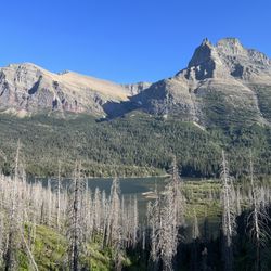
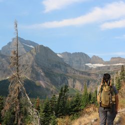
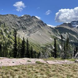
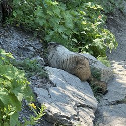
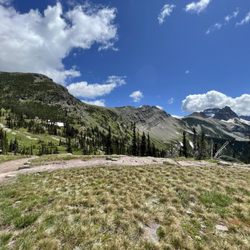
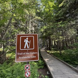
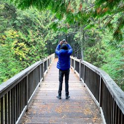
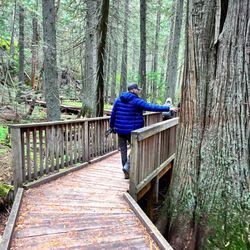
For me, Grinnell Lake gets 4.5 stars. The ONLY REASON why I didn't give it 5 stars is because when I visited in the afternoon, the magnificent backdrop was set against the sun....and admiring this setting against the sun prevented me from capturing the perfect photos. This was quite frustrating! I had read and heard wonderful reviews about this place...the lake and the hike to get here in general. Unfortunately, when I arrived about 3pm, you could pretty much say the sun was a huge obstacle and quite a hindrance on my memories from here. Ultimately, I had to wait for clouds and or move myself to different spots to avoid the sun's beams. Regardless.....everything about this hike was pretty good. Grinnell Lake is located in the more secluded section of the Many Glacier area of Glacier National Park. When I visited last month, I had to wait in a line of cars just to gain access to Many Glacier. Because this popular part of Glacier NP is quite small in circumference....park rangers were only permitting a limited amount of visitors. Wow, that was quite annoying. Fortunately for me, since I planned my itinerary ahead of time, I was spending the evening here in Many Glacier and told the park ranger that I was sleeping the night at the Swiftcurrent Motor Inn, (which was the actual truth)...so he allowed me to pass. The trail for Grinnell Lake starts right next door on the grounds of Many Glacier Hotel. You can park wherever...on the side of the streets or in the parking lot. If you have a free moment, absolutely venture inside Many Glacier Hotel and along the grounds as the hotel exudes a rustic/European style - Swiss chalet - certainly lending itself to the heart of this outdoorsy - natural - setting along Josephine Lake. For Grinnell Lake, look for signs for the Swiftcurrent Lake Loop Trail. Here is where you want to go. It's situated towards the rear of Many Glacier Hotel. Ask someone inside the lodge if you need assistance finding the trailhead. From the Swiftcurrent Foot Trail, Grinnell Lake is 3.4 miles EACH WAY! Yes...that's almost 7 miles round trip! And, you could venture further towards Grinnell Glacier....another fantastically recommended trail, but....to Grinnell Glacier, it's 5.9 miles EACH WAY, - and for me....this was too far and took too much time out of the day. Also, it's mentioned in your park's map guide that Grinnell Glacier is a STRENUOUS TRAIL....where - as just hiking to Grinnell Lake is a moderately navigated passageway. Upon trekking beside Josephine Lake making my way towards Grinnell Lake, there were plenty of photo opportunities as the lake was quite picturesque, especially when the sun was at my back. Past Josephine Lake, the surroundings were just alright. Please understand though, this trail is great for those looking to get away and immerse themselves in the back country woods. You can find an easier way to arrive at Grinnell Lake by taking a boat towards the other end of Josephine Lake, getting out and then trekking the remaining distance on. For me, I was okay simply hiking as I didn't want to pay a fee and then wait for a boat to launch. Finally coming upon Grinnell Lake, yes...the hike was worth it. The calm waters here were immaculate. Absolutely perfect....colorful blue/green and turquoise. Along with the majestic and scenic background....you're confronted with a lush green mountain carved away with a running waterfall centered in the heart of it all. This spot and panoramic view was worth it all! All the time spent hiking and traversing my way, coming here made for witnessing this grand view. I was totally impressed! Yeah...leisurely, unobtrusively sitting down and appreciating this landscape is the reason why you come here. I spent a good 45 minutes just relaxing, taking photos and reflecting on how beautiful this place was. And like I mentioned earlier, had it not been for the sun in my way, Grinnell Lake absolutely would have been 5 stars. Lol....so when all is said and done....I HAVE TO RECOMMEND TO ANYONE WHO READS THIS....HIKE TO GRINNELL LAKE IN THE MORNING!!! And although from here, it's only a couple more miles along towards Grinnell Glacier (which was highly recommended), I was satisfied that I had explored enough and ventured back towards the Many Glacier Lodge. In all, I spent about 4 - 5 hours hiking over to Grinnell Lake. If you're spending time in this Many Glacier section of Glacier National Park, Grinnell Lake is quite the highlight and should not be missed. read more


More info about Grinnell Lake
1 Rte 3
Babb, MT 59411
Directions
Hours
Outdoor Amenities


Grinnell Lake - hiking - Updated July 2026
Best of Babb
People found Grinnell Lake by searching for…
Trending Searches in Babb, MT
Browse Articles
Browse Nearby
Browse Brands
Related Searches in Babb, MT
Best Fishing Locations and Guides in Babb, Montana
Best Lookout Points to Visit in Babb, Montana
Best Nature Trails for Hiking in Babb, Montana
Best Places for Horseback Riding in Babb, Montana
Best Waterfalls and Swimming Holes in Babb, Montana
Check Out Off Road Trails in Babb, Montana
Discover Popular Bike Trails in Babb, Montana
Discover Popular Photo Spots in Babb, Montana
Discover Top Nature Parks to Visit in Babb, Montana
Discover a Hiking Trail in Babb, Montana
Discover the Best Night Hike Trails in Babb, Montana
Dog-Friendly Hikes With Dogs in Babb, Montana
Enjoy Camping Adventures Around Babb, Montana
Enjoy Off Leash Dog Hikes in Babb, Montana
Enjoy Scenic Night View Experiences in Babb, Montana
Enjoy Tent Camping Spots Around Babb, Montana
Enjoy the Best Night View Spots in Babb, Montana
Enjoy the Best Walking Trails in Babb, Montana
Experience Stunning Sunset Views in Babb, Montana
Explore Bike Rentals Throughout Babb, Montana
Explore Easy Hikes Perfect for All in Babb, Montana
Explore Popular Campgrounds Near Babb, Montana
Explore Popular RV Parks Around Babb, Montana
Explore Popular Scenic Overlook Points in Babb, Montana
Explore Popular Scenic Views Near Babb, Montana
Explore Popular State Park Destinations in Babb, Montana
Explore Popular View Points Around Babb, Montana
Explore Scenic Lakes to Visit in Babb, Montana
Explore Secret Spots Worth Visiting in Babb, Montana
Explore the Best Boating Spots in Babb, Montana
Family Friendly Hiking With Kids in Babb, Montana
Find Beautiful Views in Babb, Montana
Find Cozy Camping Cabins in Babb, Montana
Find Exciting Tours to Take in Babb, Montana
Find Fun Kids Activities Outdoor in Babb, Montana
Find Top-Rated Waterfalls in Babb, Montana Now
Find the Best Scenic View Locations in Babb, Montana
Hiking Trails With Waterfalls in Babb, Montana
Perfect Spots to Watch Sunset in Babb, Montana
Plan a Scenic Drive Route Near Babb, Montana
Popular Fishing Spots to Explore in Babb, Montana
Popular Kids Activities in Babb, Montana
Popular Places to Walk Around in Babb, Montana
Popular Things to Do in Babb, Montana
Safe River Swimming Areas in Babb, Montana
Top Hiking Trails to Explore in Babb, Montana
Top Running Trails to Explore in Babb, Montana