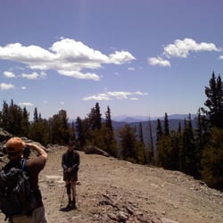
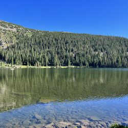
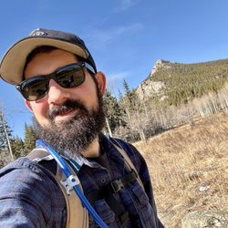
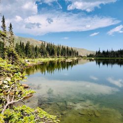
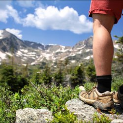
Gray's Peak Photos


You might also consider
More like Gray's Peak
Recommended Reviews - Gray's Peak
Start your review...

Reviews With Photos

Activity Type: Hiking Nearby City: Georgetown Length: 9 total miles Elevation Gain: 3,640 feet Trail Type: Out-and-back Skill Level: Generally well marked and easy to follow. Duration: 7 hours Season: Midsummer through mid-fall. The higher parts of the trail are usually covered with snow from November through mid-July Local Contacts:Mount Evans Wilderness Area, Arapaho National Forest Grays and Torreys Peaks are the two highest points on the Continental Divide. Torreys at 14,270 was named after John Torrey, an early nineteenth-century botanist who is best remembered for his work in classifying North American flora. Grays Peak at 14,270 was named in recognition of Asa Gray, also a well known botanist in the mid 1800s, whose research on variations in plant species provided important evidence in support of Charles Darwin's Theory of Evolution. The Grays Peak Trail has recently been designated as a National Recreational Trail, and it is one of the best maintained of any of the fourteener trails. The trail approaches the peak through a gorgeous glacial valley. The valley ends at the foot of the Continental Divide below the saddle connecting Grays Peak with Torreys. We started with Grays which is to the left on your way up. I have seen people with different levels of hiking capability. Most people made it half way. It is a relentless uphill climb. In hindsight I would've done Torreys first although I was advised otherwise. Just because Torreys to me is definitely a bit more than its neighbor Grays. To be recognized as having submitted a peak you must do a 3000 climb or ascend. This climb puts you at 3,640 total ascend. A well maintained trail doesn't mean a walk in the park. It is rocky. Steep and rocky is equals to a problem downhill. Not sure footed? Your friendly hiking pole should come with you. A few areas to stop and take pictures of these two is definitely a must. On the day we came we took our time. Check NOAA before you leave home. Its the best source for weather prediction. I knew a storm wouldn't be coming in at all. The top is a different story. Howling wind and not much of a space when crowded with people pushed us to stay a few minutes only. Enough to get over to Torreys and down. At the bottom where the trail starts you will see a bathroom. Unfortunately I can say this is the worst bathroom I've seen. AND I have seen a lot in the wilderness. Parking. Early bird gets the worms. Figure it out. Happy trails and on to more 14ers for me!

This review is for both Grays and Torreys Peaks. I heard so many people talking about these 14ers and if it weren't for the floods last fall then I would have already done these. Alas, I finally had the chance to try to conquer these. Last week, a park ranger told us there is no such thing as an easy 14er. It's an accomplishment to ascend one in a day but two is really amazing to do! Unlike other reviews, I absolutely wouldn't recommend this one for a first 14er. Go to Bierstadt for that. Several people were on their first ascent and getting their butt kicked. We were there on our way to the trail head at 6:30AM and it still took us nearly 45 minutes to get there because parking was taken and/or the road was only accessible by 4x4 beyond a certain point. We opted to hit Grays Peak first. The ascent was not too bad and the views were absolutely spectacular. I could see why some first timers would attempt this peak. The challenge came with Torreys Peak. It isn't that is was super hard but I think that just getting to Grays Peak takes a lot of out you that you really start feeling it at some point. Again, the views were great but Grays takes the prize out of these two. This hike is 8.35 miles for both peaks and ascends 3,366 feet. It took us exactly 7 hours to the minute trailhead to trailhead. From our car, it was 8 hours 24 minutes. In my opinion, for a first timer, I would definitely do Bierstadt first. That is amazing hike with great views and I think it's a bit easier than either of these and definitely easier than trying to do both of these in a single day.

The trail was nice, well kept, clean, and it was nice. There was snow and beautiful wild flower and a few animals. This was my first 14er but we hike and are in good shape and my group has been on a few. The trail to Grays Peak took us 2-1/2 hours and we took our time. This trail has an option to do two peaks (for new people means you hike up 1/2 then you see two paths one to Grays and one to Torreys Peak and it makes sense to do both you can make it a loop). We would not bring kids this was a challenge. Took an 1-1/2 hours to get down. One thing to know is you need an experienced driver to get to the base in the summer. You will not make it up if you do not have an all wheeled but should have a jeep, 4wd truck or atv. The drive is hard and scary!! Parking is limited we got there on a Friday morning during the summer at 5:30 and the parking was 75% full. We did it in middle of July and it was 50 degrees when we started 6am it was cool, we wore yoga pants, hiking boots with two pairs of sock (my sister wore her military boots and was great). We had on a tank top, long sleeve shirt, wind breaker, cotton gloves, ear warmer and we were a little cold and we wore the long sleeved shirt the whole trip. It got cold at the top and whenever the wind was up it got chilly (it was a high of 92 in Denver). Worth the hike the view was pretty.

Gray's Peak has been one of my favorite hikes since moving to Colorado. Accessibility wise, this is one of the more tough 14ers to get to simply because of the road condition and lack of parking up top. I highly recommend a vehicle with a decent amount of clearance, think SUV/pick-up/Jeep. I did see a few sedans make it up but it was definitely tricky and nerve wracking to watch. We camped out on a Friday night, plenty of free spots available, and woke up at 1:30am so that we could begin the hike and get to the peak in time for sunrise. The views were stunning! I didn't have it in me to continue to Torrey's Peak, so I'll have to return some day to complete that one as well. If you ever get the chance, definitely do this 14er at sunrise! You will not regret it!

Ok, so I'm being a little bit of a copy-cat here (gasp...I know!) and copying Dan W. in reviewing a 14er. But I had to. I just had to. Gray's was my first fourteener of the summer and a fabulous way to start. I would recommend this mountain to anyone who is a 14er "virgin" and looking for their first mountain to climb. It has a wide and very well-worn trail much of the way to the top, so much so that E refers to it as the "I-70 of 14er trails." It gains about 3000 feet of elevation in 3 and 1/2 miles, pretty standard for a 14er trail, and very doable even if you aren't even remotely in shape (like I was) and do okay with the elevation. It was the second 14er out of three total that I've summitted - it was by far my favorite hike, although I have to say that the view from Yale has yet to be surpassed, even by Gray's. Still, the view from the top is beyond words. It made me cry...no seriously, it made me cry. After hours of hiking (being out-of-shape, it took me longer than I would have liked) in bad weather, the rewarding view was enough to stir up my volatile woman hormones and open the flood gates. It made E a little uncomfortable... This is an awesome trail for doggies who are up to the task...both Champ and Aspen took part in this summit, and there were MANY other dogs on the trail, kind of like a nomadic dog park. Aspen delighted in sniffing and stalking pikas (little rodents that sound like squeaky toys so OBVIOUSLY he's interested) and rolling in the snow fields that were hanging on even in August. He got lots of compliments on his dog booties too, which prevent him from rubbing his feet raw. A great hike. A beautiful view. And another 14er you can cross off your list. Isn't life in Colorado grand?


5 years ago
Friday 8-6-2021 The 3 mile dirt road from the parking lot off i70 up to the trailhead is ROUGH. If you do not have a higher clearance vehicle i would not try this. I have a honda pilot and it did okay but i will definitely not be driving it again. It was really rough on the car. Lots of ruts, wash outs and rocks sticking out. Road is narrow would not be a fan of seeing what happens if vehicles are wanting to go both up and down at same time. There is no parking along the 3 mile road stretch. There are signs along the road on trees. Please obey the signage! At 6 am, we did find parking near the trailhead. There is a bathroom at the trailhead. There is no trash. So please plan on packing out what you take with you. Dogs are allowed but if you are going to bring them please make sure they are on a leash or under GREAT voice command. Was watching some wildlife and somebody and their dog came chased them off. It was really quite sad. The elusive white tailed ptarmigan, they had very little regard for the wildlife. have seen this happen on other trails with the mountain goats as well. so please only bring your dog if you are going to control the dog. The trail is well marked and easy to follow. The wildflowers are absolutely amazing right now! wow a sea of yellows, red, purple, pink. It was so pretty!!! It is also very green right now. You feel like you are surrounded by a sea of giant towering mountains. The incline up to gray was definitely mentally challenging. We got to the top and it was pretty cold and windy. Could not find the geological markers for either of the peaks. Neither could anyone else. Not sure where they disappeared to. Going from Grays to Torreys. The rocks were slick. This was an area i wish i had hiking poles for. From here, the hike up to torreys was shorter but steep. It was quite lovely though. I think i loved the view from Torreys best if i had to pick. Gray clouds were rolling in at 11 am. We were on our way down but lots of people were just on their way up. Be sure you be aware of the weather conditions if you are going to do this peak. Thunderstorms on the peak are definitely not a joke. read more


Great hike for first 14er! Still a challenging hike and gets crowded. The parking area does get full and the road is pretty bumpy and has a few big potholes. Be prepared to walk up the road some unless you get there crazy early and are able to park in the lot. Incredible views. If you're up for it you can also do Torreys Peak on the same day. We did them on two different days. read more

Activity Type: Hiking Nearby City: Georgetown Length: 9 total miles Elevation Gain: 3,640 feet Trail Type: Out-and-back Skill Level: Generally well marked and easy to follow. Duration: 7 hours Season: Midsummer through mid-fall. The higher parts of the trail are usually covered with snow from November through mid-July Local Contacts:Mount Evans Wilderness Area, Arapaho National Forest Grays and Torreys Peaks are the two highest points on the Continental Divide. Torreys at 14,270 was named after John Torrey, an early nineteenth-century botanist who is best remembered for his work in classifying North American flora. Grays Peak at 14,270 was named in recognition of Asa Gray, also a well known botanist in the mid 1800s, whose research on variations in plant species provided important evidence in support of Charles Darwin's Theory of Evolution. The Grays Peak Trail has recently been designated as a National Recreational Trail, and it is one of the best maintained of any of the fourteener trails. The trail approaches the peak through a gorgeous glacial valley. The valley ends at the foot of the Continental Divide below the saddle connecting Grays Peak with Torreys. We started with Grays which is to the left on your way up. I have seen people with different levels of hiking capability. Most people made it half way. It is a relentless uphill climb. In hindsight I would've done Torreys first although I was advised otherwise. Just because Torreys to me is definitely a bit more than its neighbor Grays. To be recognized as having submitted a peak you must do a 3000 climb or ascend. This climb puts you at 3,640 total ascend. A well maintained trail doesn't mean a walk in the park. It is rocky. Steep and rocky is equals to a problem downhill. Not sure footed? Your friendly hiking pole should come with you. A few areas to stop and take pictures of these two is definitely a must. On the day we came we took our time. Check NOAA before you leave home. Its the best source for weather prediction. I knew a storm wouldn't be coming in at all. The top is a different story. Howling wind and not much of a space when crowded with people pushed us to stay a few minutes only. Enough to get over to Torreys and down. At the bottom where the trail starts you will see a bathroom. Unfortunately I can say this is the worst bathroom I've seen. AND I have seen a lot in the wilderness. Parking. Early bird gets the worms. Figure it out. Happy trails and on to more 14ers for me! read more


12 years ago
This review is for both Grays and Torreys Peaks. I heard so many people talking about these 14ers and if it weren't for the floods last fall then I would have already done these. Alas, I finally had the chance to try to conquer these. Last week, a park ranger told us there is no such thing as an easy 14er. It's an accomplishment to ascend one in a day but two is really amazing to do! Unlike other reviews, I absolutely wouldn't recommend this one for a first 14er. Go to Bierstadt for that. Several people were on their first ascent and getting their butt kicked. We were there on our way to the trail head at 6:30AM and it still took us nearly 45 minutes to get there because parking was taken and/or the road was only accessible by 4x4 beyond a certain point. We opted to hit Grays Peak first. The ascent was not too bad and the views were absolutely spectacular. I could see why some first timers would attempt this peak. The challenge came with Torreys Peak. It isn't that is was super hard but I think that just getting to Grays Peak takes a lot of out you that you really start feeling it at some point. Again, the views were great but Grays takes the prize out of these two. This hike is 8.35 miles for both peaks and ascends 3,366 feet. It took us exactly 7 hours to the minute trailhead to trailhead. From our car, it was 8 hours 24 minutes. In my opinion, for a first timer, I would definitely do Bierstadt first. That is amazing hike with great views and I think it's a bit easier than either of these and definitely easier than trying to do both of these in a single day. read more

8 years ago
9 years ago
The trail was nice, well kept, clean, and it was nice. There was snow and beautiful wild flower and a few animals. This was my first 14er but we hike and are in good shape and my group has been on a few. The trail to Grays Peak took us 2-1/2 hours and we took our time. This trail has an option to do two peaks (for new people means you hike up 1/2 then you see two paths one to Grays and one to Torreys Peak and it makes sense to do both you can make it a loop). We would not bring kids this was a challenge. Took an 1-1/2 hours to get down. One thing to know is you need an experienced driver to get to the base in the summer. You will not make it up if you do not have an all wheeled but should have a jeep, 4wd truck or atv. The drive is hard and scary!! Parking is limited we got there on a Friday morning during the summer at 5:30 and the parking was 75% full. We did it in middle of July and it was 50 degrees when we started 6am it was cool, we wore yoga pants, hiking boots with two pairs of sock (my sister wore her military boots and was great). We had on a tank top, long sleeve shirt, wind breaker, cotton gloves, ear warmer and we were a little cold and we wore the long sleeved shirt the whole trip. It got cold at the top and whenever the wind was up it got chilly (it was a high of 92 in Denver). Worth the hike the view was pretty. read more

Gray's Peak has been one of my favorite hikes since moving to Colorado. Accessibility wise, this is one of the more tough 14ers to get to simply because of the road condition and lack of parking up top. I highly recommend a vehicle with a decent amount of clearance, think SUV/pick-up/Jeep. I did see a few sedans make it up but it was definitely tricky and nerve wracking to watch. We camped out on a Friday night, plenty of free spots available, and woke up at 1:30am so that we could begin the hike and get to the peak in time for sunrise. The views were stunning! I didn't have it in me to continue to Torrey's Peak, so I'll have to return some day to complete that one as well. If you ever get the chance, definitely do this 14er at sunrise! You will not regret it! read more


Ok, so I'm being a little bit of a copy-cat here (gasp...I know!) and copying Dan W. in reviewing a 14er. But I had to. I just had to. Gray's was my first fourteener of the summer and a fabulous way to start. I would recommend this mountain to anyone who is a 14er "virgin" and looking for their first mountain to climb. It has a wide and very well-worn trail much of the way to the top, so much so that E refers to it as the "I-70 of 14er trails." It gains about 3000 feet of elevation in 3 and 1/2 miles, pretty standard for a 14er trail, and very doable even if you aren't even remotely in shape (like I was) and do okay with the elevation. It was the second 14er out of three total that I've summitted - it was by far my favorite hike, although I have to say that the view from Yale has yet to be surpassed, even by Gray's. Still, the view from the top is beyond words. It made me cry...no seriously, it made me cry. After hours of hiking (being out-of-shape, it took me longer than I would have liked) in bad weather, the rewarding view was enough to stir up my volatile woman hormones and open the flood gates. It made E a little uncomfortable... This is an awesome trail for doggies who are up to the task...both Champ and Aspen took part in this summit, and there were MANY other dogs on the trail, kind of like a nomadic dog park. Aspen delighted in sniffing and stalking pikas (little rodents that sound like squeaky toys so OBVIOUSLY he's interested) and rolling in the snow fields that were hanging on even in August. He got lots of compliments on his dog booties too, which prevent him from rubbing his feet raw. A great hike. A beautiful view. And another 14er you can cross off your list. Isn't life in Colorado grand? read more

9 years ago
Absolutely stunning. On a visit from Florida I thought it'd be a great idea to tag along with some friends who live in Colorado to hike a 14er. HAH! It was a long bumpy small road to get to the parking area, which was quaint with restrooms. We started the hike up to the top and got to about 11,000 feet before we had to turn back because of the snow and ice. Would love to come back during season because the views from even 11k feet were just beautiful. read more


13 years ago
More info about Gray's Peak
Arapaho National Forest
Idaho Springs, CO 80452
Directions
Visit Website
http://www.14ers.com
Hours
Indoor Amenities
Outdoor Amenities
Ask the Community - Gray's Peak
Review Highlights - Gray's Peak


Why does Yelp recommend reviews?
1 review that is not currently recommended
The reviews below are not factored into the business's overall star rating.
13 years ago
Gray's Peak - hiking - Updated May 2026
Best of Idaho Springs
People found Gray's Peak by searching for…
Things to Do in Idaho Springs, Colorado
Parks in Idaho Springs, Colorado
Flower Fields in Idaho Springs, Colorado
Sunrise View in Idaho Springs, Colorado
Hiking Trails in Idaho Springs, Colorado
Beautiful Views in Idaho Springs, Colorado
Scenic View in Idaho Springs, Colorado
Dog Friendly Hiking Trails in Idaho Springs, Colorado
Scenic Overlook in Idaho Springs, Colorado
Off Leash Dog Hiking Trails in Idaho Springs, Colorado
Off Road Trails in Idaho Springs, Colorado
Dog Friendly Parks in Idaho Springs, Colorado
Night Hike in Idaho Springs, Colorado
Easy Hikes in Idaho Springs, Colorado
Walking Trails in Idaho Springs, Colorado
Hikes With Dogs in Idaho Springs, Colorado
Things to Do on a Rainy Day in Idaho Springs, Colorado
Night View in Idaho Springs, Colorado
Hiking Groups in Idaho Springs, Colorado
Waterfalls in Idaho Springs, Colorado
Stair Climbing in Idaho Springs, Colorado
Running Trails in Idaho Springs, Colorado
Trending Searches in Idaho Springs, CO
Botanical Gardens near Gray's Peak
Bounce House Rentals near Gray's Peak
Cherry Picking near Gray's Peak
Cliff Jumping near Gray's Peak
Dog Friendly Things To Do near Gray's Peak
Flower Fields near Gray's Peak
Lakes & Ponds near Gray's Peak
Nurseries & Gardening near Gray's Peak
Outdoor Activities near Gray's Peak
Outdoor Furniture Stores near Gray's Peak
Party Equipment Rentals near Gray's Peak
Pick Your Own Farms near Gray's Peak
Places To Take Pictures near Gray's Peak
Plant Nursery near Gray's Peak
Running Trails near Gray's Peak
Strawberry Picking near Gray's Peak
Browse Articles
Browse Nearby
Browse Brands
Related Searches in Idaho Springs, CO
Affordable Kayak Rental Services in Idaho Springs, Colorado
Best Fishing Locations and Guides in Idaho Springs, Colorado
Best Places for Horseback Riding in Idaho Springs, Colorado
Best Sledding Spots and Fun in Idaho Springs, Colorado
Check Out Off Road Trails in Idaho Springs, Colorado
Discover Dog Friendly Trails to Explore in Idaho Springs, Colorado
Discover Kid Friendly Hiking Trails in Idaho Springs, Colorado
Discover Scenic Waterfall Spots in Idaho Springs, Colorado
Discover Top Scenic Spots to Visit in Idaho Springs, Colorado
Discover a Hiking Trail in Idaho Springs, Colorado
Discover the Best Night Hike Trails in Idaho Springs, Colorado
Dog-Friendly Hikes With Dogs in Idaho Springs, Colorado
Enjoy Camping Adventures Around Idaho Springs, Colorado
Enjoy Exciting Mountain Biking Adventures in Idaho Springs, Colorado
Enjoy Kayaking Adventures in Idaho Springs, Colorado
Enjoy River Tubing Adventures in Idaho Springs, Colorado
Enjoy Tent Camping Spots Around Idaho Springs, Colorado
Enjoy Water Activities and Fun in Idaho Springs, Colorado
Enjoy a Beautiful Waterfall Hike in Idaho Springs, Colorado
Enjoy the Best Tubing Experiences in Idaho Springs, Colorado
Enjoy the Best Walking Trails in Idaho Springs, Colorado
Exciting Cliff Jumping Spots in Idaho Springs, Colorado
Experience Thrilling White Water Rafting in Idaho Springs, Colorado
Explore Beautiful Parks and Green Spaces in Idaho Springs, Colorado
Explore Easy Hikes Perfect for All in Idaho Springs, Colorado
Explore Fun Activities to Do in Idaho Springs, Colorado
Explore Popular Campgrounds Near Idaho Springs, Colorado
Explore Scenic Lakes to Visit in Idaho Springs, Colorado
Explore the Best Beach Spots in Idaho Springs, Colorado
Explore the Best Boating Spots in Idaho Springs, Colorado
Explore the Best Swimming Holes Around Idaho Springs, Colorado
Family Friendly Hiking With Kids in Idaho Springs, Colorado
Find Popular Ziplining Spots Around Idaho Springs, Colorado
Find the Best Playgrounds to Visit in Idaho Springs, Colorado
Find the Best Scenic View Locations in Idaho Springs, Colorado
Hiking Trails With Waterfalls in Idaho Springs, Colorado
Off Leash Dog Hiking Trails in Idaho Springs, Colorado
Plan a Scenic Drive Route Near Idaho Springs, Colorado
Popular Fishing Spots to Explore in Idaho Springs, Colorado
Popular Outdoor Activities to Try in Idaho Springs, Colorado
Popular Picnic Spots to Visit in Idaho Springs, Colorado
Popular Things to Do in Idaho Springs, Colorado
Safe River Swimming Areas in Idaho Springs, Colorado
Safe and Fun Parks for Kids in Idaho Springs, Colorado
Top Climbing Spots and Gyms in Idaho Springs, Colorado
Top Playgrounds for Kids to Enjoy in Idaho Springs, Colorado
Top Running Trails to Explore in Idaho Springs, Colorado
Top Swimming Lakes to Enjoy in Idaho Springs, Colorado
People who viewed Gray's Peak also viewed
Herman Gulch Trail Head
11 reviews
Kenosha Pass
18 reviews
Mayflower Gulch Trail
7 reviews
Blue Lakes Trail Breckenridge
8 reviews
Berthoud Pass Trailhead
5 reviews
Squaw Mountain
4 reviews
Chihuahua Lake
2 reviews
Maryland Mountain Hidden Treasure Trailhead
4 reviews
Meyer Ranch Park
11 reviews
Reynolds Park Open Space
6 reviews