Fumee Falls Photos


More like Fumee Falls
Recommended Reviews - Fumee Falls
Start your review...

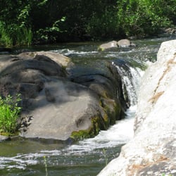
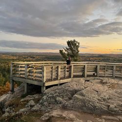
Pretty little set of 3 waterfalls on the north side of Hwy 2 in Quinnesec. There is a bridge over the stream coming from the lower falls which makes for a pretty photograph. Off to the right is a short path that leads to a staircase. At the top of the staircase is a short walkway that takes you to another set of stairs that lead down to the viewing platform. Two more small waterfalls can be seen from up here. A sweet, scenic photo of. 22/2025 read more


More info about Fumee Falls
US-2
Quinnesec, MI 49876
Directions
Hours
Outdoor Amenities


Fumee Falls - parks - Updated July 2026
Best of Quinnesec
People found Fumee Falls by searching for…
Things to Do in Quinnesec, Michigan
Attractions in Quinnesec, Michigan
Hiking Trails in Quinnesec, Michigan
Picnic Areas in Quinnesec, Michigan
Walking Trails in Quinnesec, Michigan
Running Trails in Quinnesec, Michigan
Things to See in Quinnesec, Michigan
Playgrounds in Quinnesec, Michigan
Scenic Overlook in Quinnesec, Michigan
Photo Spots in Quinnesec, Michigan
Tourist Attractions in Quinnesec, Michigan
State Parks in Quinnesec, Michigan
Bike Paths in Quinnesec, Michigan
Places to Take Pictures in Quinnesec, Michigan
Beautiful Views in Quinnesec, Michigan
What to Do in Quinnesec, Michigan
Scenic View in Quinnesec, Michigan
Fishing Lake in Quinnesec, Michigan
Waterfalls in Quinnesec, Michigan
Swimming Lakes in Quinnesec, Michigan
Trending Searches in Quinnesec, MI
Browse Articles
Browse Nearby
Browse Brands
Related Searches in Quinnesec, MI
Best Nature Trails for Hiking in Quinnesec, Michigan
Best Places for Stunning Views in Quinnesec, Michigan
Best Waterfalls and Swimming Holes in Quinnesec, Michigan
Check Out Great Playgrounds in Quinnesec, Michigan
Check Out Off Road Trails in Quinnesec, Michigan
Discover Free Parking Options in Quinnesec, Michigan
Discover Popular Bike Trails in Quinnesec, Michigan
Discover Top Nature Parks to Visit in Quinnesec, Michigan
Discover the Best Fishing Lake in Quinnesec, Michigan
Discover the Best Night Hike Trails in Quinnesec, Michigan
Dog-Friendly Hikes With Dogs in Quinnesec, Michigan
Enjoy River Tubing Adventures in Quinnesec, Michigan
Enjoy the Best Family Activities in Quinnesec, Michigan
Enjoy the Best Night View Spots in Quinnesec, Michigan
Enjoy the Best Picnic Spots and Ideas in Quinnesec, Michigan
Enjoy the Best Tubing Experiences in Quinnesec, Michigan
Enjoy the Best Walking Trails in Quinnesec, Michigan
Explore Easy Hikes Perfect for All in Quinnesec, Michigan
Explore Family-Friendly Zoos and Wildlife in Quinnesec, Michigan
Explore Landmarks & Historical Buildings in Quinnesec, Michigan
Explore Nature Spots Around Quinnesec, Michigan
Explore Popular Scenic Overlook Points in Quinnesec, Michigan
Explore Popular Scenic Views Near Quinnesec, Michigan
Explore Popular View Points Around Quinnesec, Michigan
Explore Top Gyms in Quinnesec, Michigan Now
Explore the Best Trail Options in Quinnesec, Michigan
Family Friendly Hiking With Kids in Quinnesec, Michigan
Find Beautiful Views in Quinnesec, Michigan
Find Parks and Recreation Activities in Quinnesec, Michigan
Find Picnic Tables for Outdoor Fun in Quinnesec, Michigan
Find Top Dog Swimming Spots in Quinnesec, Michigan
Find Top-Rated Waterfalls in Quinnesec, Michigan Now
Fun Indoor Activities to Try in Quinnesec, Michigan
Great Places to Swim in Quinnesec, Michigan
Must-See Tourist Attractions Around Quinnesec, Michigan
Plan a Scenic Drive Route Near Quinnesec, Michigan
Popular Outdoor Activities to Try in Quinnesec, Michigan
Popular Places to Take Pictures in Quinnesec, Michigan
Popular Things to Do in Quinnesec, Michigan
Relax at Natural Hot Springs Near Quinnesec, Michigan
Top Hiking Trails to Explore in Quinnesec, Michigan
Top Running Trails to Explore in Quinnesec, Michigan
Top Swimming Lakes to Enjoy in Quinnesec, Michigan
Top Things to Do With Kids in Quinnesec, Michigan
Top-Rated Boat Rental Services in Quinnesec, Michigan
People who viewed Fumee Falls also viewed
Diamond Point Park
4 reviews
Lake Bemidji State Park
12 reviews
Paul Bunyan Park
2 reviews
Sandtrap Golf Course
2 reviews
Alton Heights Lookout Tower
2 reviews
Castle Highlands Golf Course
3 reviews
Northern Cycle
3 reviews
Turtle River Township Community Center
1 review
Knockout Fit Club
1 review
Camp Kamaji
3 reviews