Friendship park Parks Photos


You might also consider
More like Friendship park
Recommended Reviews - Friendship park
Start your review...

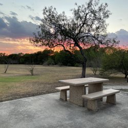
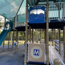
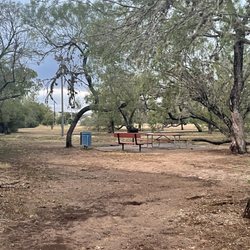
Available restrooms and water fountains, basketball court and playground. They even added benches to sit down on. Maybe if they were to keep up with broken items and replacing damaged things. Nice fun park and there's even a path to walk or jog. Pet friendly! read more


5 years ago
15 years ago
They have zumba at the park every Monday & Wednesday evenings at 7-8pm Info from instructor: Zumba every Monday and Wednesday evening from 7:00 to 8:00 pm in Friendship Park under the Pavilion. Your first class is free, and then the fee is $2 for drop ins, or you can buy a 10 class punchcard for $15 or a 20 class punchcard for $25. It is hot, but we are totally shaded and have a good breeze and drink lots of water. The fresh air is great! Wear tennis shoes (no Toner type) and bring cold water. read more
7 years ago
7 years ago
More info about Friendship park
5745 Binz Engleman
Kirby, TX 78244
Directions
Hours
Outdoor Amenities
Friendship park Reviews in Other Languages
Ask the Community - Friendship park
You might also consider


Friendship park - parks - Updated May 2026
Best of Kirby
People found Friendship park by searching for…
Basketball Courts in Kirby, TX
Free Things to Do in Kirby, TX
Playgrounds for Kids in Kirby, TX
Places to Take Pictures in Kirby, TX
Lighted Outdoor Basketball Courts in Kirby, TX
Public Tennis Courts in Kirby, TX
Running Tracks Open to the Public in Kirby, TX
Open Indoor Basketball Courts in Kirby, TX
Trending Searches in Kirby, TX
Browse Articles
Browse Nearby
BEST of Kirby, Texas Things to Do near Friendship park
BEST of Kirby, Texas Coffee near Friendship park
BEST of Kirby, Texas Splash Pad near Friendship park
BEST of Kirby, Texas Restaurants near Friendship park
BEST of Kirby, Texas Hiking near Friendship park
Browse Brands
Related Searches in Kirby, TX
Best Fishing Locations and Guides in Kirby, Texas
Best Fun Things to Do in Kirby, Texas
Best Nature Trails for Hiking in Kirby, Texas
Best Off Leash Dog Parks in Kirby, Texas
Best Parks for Parties and Events in Kirby, Texas
Best Places for Horseback Riding in Kirby, Texas
Best Water Parks for Kids in Kirby, Texas
Check Out Great Playgrounds in Kirby, Texas
Discover Baseball Fields Around Kirby, Texas
Discover Beautiful Garden Spots in Kirby, Texas
Discover Free Parking Options in Kirby, Texas
Discover Fun Activities to Do in Kirby, Texas
Discover Fun Toddler Parks in Kirby, Texas for Your Little One
Discover Popular Photo Spots in Kirby, Texas
Discover Soccer Fields in Kirby, Texas Near You
Discover Top Nature Parks to Visit in Kirby, Texas
Enjoy the Best Picnic Spots and Ideas in Kirby, Texas
Enjoy the Best Walking Trails in Kirby, Texas
Explore Beautiful Botanical Gardens in Kirby, Texas
Explore Free Picnic Areas Around Kirby, Texas
Explore Free Things to Do Around Kirby, Texas
Explore Kid Friendly Places and Events in Kirby, Texas
Explore Landmarks & Historical Buildings in Kirby, Texas
Explore Parks With Pull Up Bars in Kirby, Texas
Explore Popular Picnic Areas Around Kirby, Texas
Explore Popular RV Parks Around Kirby, Texas
Explore Scenic Lakes to Visit in Kirby, Texas
Explore Top Gyms in Kirby, Texas Now
Explore Top Water Parks in Kirby, Texas Today
Find Beautiful Views in Kirby, Texas
Find Parks and Recreation Activities in Kirby, Texas
Find Top Dog Friendly Parks to Visit in Kirby, Texas
Find Top Skate Parks in Kirby, Texas for All Skill Levels
Find Top-Rated Waterfalls in Kirby, Texas Now
Find a Park With BBQ Pits in Kirby, Texas
Find the Best Parks BBQ Grills in Kirby, Texas
Find the Best Parks for Picnics in Kirby, Texas
Find the Best Swimming Pools in Kirby, Texas Today
Have Fun at a Splash Pad in Kirby, Texas
Must-See Tourist Attractions Around Kirby, Texas
Parks With Basketball Courts for Games in Kirby, Texas
Picnic Areas With BBQ Pits Available in Kirby, Texas
Popular Kids Activities in Kirby, Texas
Popular Things to Do in Kirby, Texas
See Top Fireworks Events in Kirby, Texas
Top Hiking Trails to Explore in Kirby, Texas
Top Things to Do With Kids in Kirby, Texas
Top-Rated Hikes in Kirby, Texas to Explore