Fort Barton Photos


You might also consider
More like Fort Barton
Recommended Reviews - Fort Barton
Start your review...

Reviews With Photos - Fort Barton

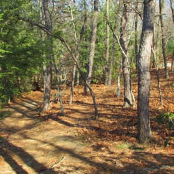
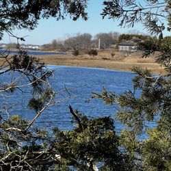
This is a fun place to visit, located just minutes from our home. It starts off with a short, but strenuous uphill walk from the street parking area to the observation tower that you can climb for a panoramic view of Narragansett Bay. The trail head for Fort Barton Woods is to the rear, beginning with steep descending steps, then an upward climb onto the trail leading into Fort Barton Woods. Fort Barton Woods is 83-acres, with 3.5 miles of trails that take you along the crystal clear Sin and Flesh Brook. While on the trail you will come across many bridges, brooks, steps, steep climbs, birds, cool rocks, lovely flowers, animal habitats, snakes and gunfire... Yes.. GUNFIRE. lol (there is a shooting range nearby so do NOT be alarmed when you start to hear BANG, BANG, BANG) lol I was born and raised here in Tiverton and have heard many stories regarding Sin and Flesh Brook, where a massacre took place centuries ago and many people have seen and are still seeing ghostly apparitions. So be sure to keep your eyes open!! ;) I do suggest you stay on the trails and recommend that you are in descent physical shape because there are some sections that could be very strenuous/exhausting to some.
So many paths, so little time! What a picturesque, clean and well kept park! I decided that the weather is warm enough and, to be honest, I needed to get the teenagers out of the house to burn off some energy. They loved it! The trails were difficult enough to get your heart pounding and your glutes burning, but not so difficult that we had to stop. Although, if we did, I'm pretty sure we would have enjoyed our beautiful surroundings even more! We will definitely be back to discover more!
Just went for a ride with my daughter & pup stumbled apon this little hide away! Never hiked ever, it's not that bad very easy (I know there is harder trails out there). Just needed to get out with the pup from being stuck in the house for days due to all the rain! Very breath taken, would do it again

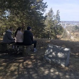
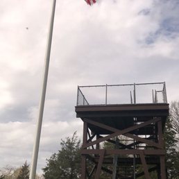
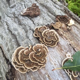
History haunted streams pudding stones and of course lots of dead people Fort Barton and the contiguous Barton Woods are some of the most interesting and fun places in all of Rhode Island. The Fort dates back to the Revolutionary War and is named in honor of Colonel William Barton. Barton was the leader of one of the most incredible and daring raids of the war. Through spies he found out that the British General Prescott usually spent the night at a friends house rather than the usual military barracks. Various accounts differ about exactly how intimate this friendship was but when Barton heard that Prescott slept virtually unguarded he got some brave men, rowed across Narragansett Bay and captured the general. Quite a morale boost for the Americans and embarrassment for the British. The fort is now only a few earthen mounds but it does have a cool observation tower that gives beautiful views of the bay. From the fort you can follow the trails right into the hilly, rocky and spooky Barton Woods. Easy to get lost, but the woods aren't really that large so you will probably eventually get back to the fort. Lots of cool rocks, trees and mud with little bridges and steep climbs to kill yourself on. One particular stone that is found here is called Puddingstone and is a conglomerate that has lots of smaller stones mixed in it. It looks like a form of cement but is natural stone that is very unusual and bizarre looking. It gets it's name because someone apparently thought it looks like pudding. The entire area is hobnobbed with brooks and streams, some with rather creative and descriptive names. Sin and Flesh Brook is where a massacre took place centuries ago and people supposedly still find pieces of flesh from the victims in the water and see ghostly apparitions lugubriously walking around. However doubtful these particular stories may be, the woods are dark and murky and of course the usually diminutive and ancient graveyards with the worn tombstones are present. Unfortunately not much parking is available but then this place never seems to get very crowded. Perhaps it's just too hilly, too muddy, too rocky or too spooky for most people. That's too bad because the dead and the ghosts don't seem to mind the company.

Need to kill a few hours wandering down revolutionary era trails? Then come to Fort Barton and be fulfilled. While little remains of the old fort - some steep hills I wouldn't want to ascend in battle - the area is a veritable gold mine for lovers of trails and history enthusiasts alike. Paths chocked full of stones and gnarled roots that have been weathered flat over time lead hikers into the same woods where a murder occurred in 1676. A Quaker was traveling from Dartmouth to Newport and was killed by 6 Native Americans. A fairly routine happening for the time, right? Maybe so, but in this incident, the body was left to rot near a stream. Once the decomposing corpse was discovered, the Sin and Flesh Brook was aptly named. The views from atop the structure built on the original fort are nothing short of breathtaking. A plaque on the ground identifies all the communities visible from the summit. If I was involved, I would have placed it at the top of the observation station because, well, you know...that's where the view is. Follow the red path for what seems to be easy hiking. The blue trail seems to be given less attention and traverses more difficult terrain. It's easy to get lost in these woods, but you're never too far from civilization, so relax and get off the beaten track. My advice: Follow the streams for views the trails cannot afford. Oh, and bring lots of bug spray.
This place was amazing. Challenging but not deadly. So much to see. So many bridges and brooks. Found a toad, my favoritest thing ever. Sorry snake I stepped on but damn I didn't see him because I was looking at the cool bench I was walking up on. Lots of hills and steep steps and just fun things to see. In the beginning there was a lookout the military used back in the day. The town of Tiverton made it safe to climb up. There was a tiny old cemetery as well. If anyone else has read my prior reviews, then you know my favoritest thing to have is a trail map in my hand and clearly marked trails. We had a winner here, folks!!! We picked the red trail as it was the longest although they all intertwine and you could make it as long as you wanted. It was perfect for my son who is six. Bridges bridges and more bridges. Steps galore all over the place. Streams that I'm sure in springtime will be overflowing but since we haven't had much rain lately they weren't huge. It didn't take away from the beauty of the place though. It is a dog friendly place. They leave "doggie bags" for you to take at the entrance. We encountered a small handful of people but mostly in the beginning/end. So it was quite peaceful. However, in regards to peaceful, I'll warn you now; I'm assuming there is a shooting range nearby because at the back of the loop we got the crap scared out of us with sudden gunshots. I watch too many horror movies and my first thought went in that direction until I thought about it for a second. Once I realized we must be near a range I lost my urge to trample my people and beat feet leaving them to fend for themselves. The red trail was an approximate 3 mile loop and my six year old kicked its ass. I was proud. And we absolutely loved this adventure. I suggest you go and see for yourself.

For 30 years we've been coming here and although the terrain hardly changes at all, everything else IS ever changing-moving-growing-rotting-flourishing-living it's never a disappointment. Taking pictures is all consuming you may need a spare battery or an extra storage card on your camera. We have spent up to 3 hrs entertaining ourselves, going back to the car for a snack or to regroup. Rhode Island takes exemplary care of this park, as the stairs and bridges are solid and the property is as pristine as the laws of state and nature would allow. Walking around the paths with surprise passes with dogs of all breeds, all in harmony, all on leash and so far all love a scratch behind the ears. Maybe a quick chat with fellow walkers as everyone respectful and courteous. As far as the Tiverton Gun Club in front of it, yes, it can be exhilarating hearing the guns going off during target practice. But not frightening or scary be assured they are shooting away from you, it is what it is.. decades of harmony between the two properties. No one is shooting at you. Save The watch tower for last, as tired as you'll be, you MUST finish here. The heights bring breath taking views like no other and I guarantee you will sleep tonight after a few hours of stairs, roots, rocks, bridges, fallen trees, hills and valleys ...oh yes and FRESH AIR.. zzzzzzz ps: kids should be in a sturdy shoe no flip-flops, just saying..

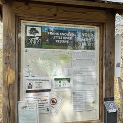
I made the mistake of going for a hike on the Red Trail loop on a Saturday the end of May. What no sign or map of the park tells you is that there is a rifle range literally adjacent to the trails. What would have been a pleasant, tranquil stroll made me think I was back in Southeast Asia. At 2:30 in the afternoon I counted shots going off at the rate of one every few seconds. Not knowing the range even existed I hiked wondering if we were behind or in front of the shooters. It made for an interesting hike. So... 1. This could be a nice tranquil hike through the woods and vernal pools and streams... but _stay away during spring/summer weekends._ Unless you want flashbacks to your favorite war zone. 2. If you're a local you already know all of this. 3. However, if you're a first time visitor the city of Tiverton has a great trail map http://www.tiverton.ri.gov/documents/recreation/FtB_TrailGuide.pdf - with one glaring omission - it has no mention of the shooting range. Leaving out any mention of bullets flying is disingenuous to say the least,. 4. To be useful for visitors, all it would take is to annotate the map with a note saying the gunfire is normal and shots are being fired away from the trails.
")
Hiked this yesterday and can't wait to go back again to see the amazing sunset from the top. I parked in front of the town hall. There were a few spots open there just not sure if there are any more. I'll update when I go back. Absolutely beautiful view at the top. Got my heart rate up and my legs are a little sore today. This will be a go to hike for me since I'm so close. Highly recommend especially for that view! read more


A nice trail overall with a great view of the waterfront if you climb the tower near the beginning of the trail. Small parking lot that can be a little tricky to back out of. Trail is across from Tiverton Town Hall. Plenty of ups and downs and a generally fun trail to hike. Unfortunately, a damper was put on the day, by an off leash dog that came charging at me ahead of their owner that I had to pepper spray. And to have owner blame me, even though she was the one ignorant of the leash law. Please if you hike/walk these trails be mindful and respectful of your fellow walkers/hikers and follow the law. read more


6 years ago
A very nice walking trail with a scenic overlook at the top. The path takes you through wooded areas with marshes, hills, and other beautiful scenic surroundings. It is definitely a good place to go for a walk in the early spring when everything is starting to come to life. read more


9 years ago
This is a fun place to visit, located just minutes from our home. It starts off with a short, but strenuous uphill walk from the street parking area to the observation tower that you can climb for a panoramic view of Narragansett Bay. The trail head for Fort Barton Woods is to the rear, beginning with steep descending steps, then an upward climb onto the trail leading into Fort Barton Woods. Fort Barton Woods is 83-acres, with 3.5 miles of trails that take you along the crystal clear Sin and Flesh Brook. While on the trail you will come across many bridges, brooks, steps, steep climbs, birds, cool rocks, lovely flowers, animal habitats, snakes and gunfire... Yes.. GUNFIRE. lol (there is a shooting range nearby so do NOT be alarmed when you start to hear BANG, BANG, BANG) lol I was born and raised here in Tiverton and have heard many stories regarding Sin and Flesh Brook, where a massacre took place centuries ago and many people have seen and are still seeing ghostly apparitions. So be sure to keep your eyes open!! ;) I do suggest you stay on the trails and recommend that you are in descent physical shape because there are some sections that could be very strenuous/exhausting to some. read more


7 years ago
So many paths, so little time! What a picturesque, clean and well kept park! I decided that the weather is warm enough and, to be honest, I needed to get the teenagers out of the house to burn off some energy. They loved it! The trails were difficult enough to get your heart pounding and your glutes burning, but not so difficult that we had to stop. Although, if we did, I'm pretty sure we would have enjoyed our beautiful surroundings even more! We will definitely be back to discover more! read more


7 years ago
Just went for a ride with my daughter & pup stumbled apon this little hide away! Never hiked ever, it's not that bad very easy (I know there is harder trails out there). Just needed to get out with the pup from being stuck in the house for days due to all the rain! Very breath taken, would do it again read more


16 years ago
History haunted streams pudding stones and of course lots of dead people Fort Barton and the contiguous Barton Woods are some of the most interesting and fun places in all of Rhode Island. The Fort dates back to the Revolutionary War and is named in honor of Colonel William Barton. Barton was the leader of one of the most incredible and daring raids of the war. Through spies he found out that the British General Prescott usually spent the night at a friends house rather than the usual military barracks. Various accounts differ about exactly how intimate this friendship was but when Barton heard that Prescott slept virtually unguarded he got some brave men, rowed across Narragansett Bay and captured the general. Quite a morale boost for the Americans and embarrassment for the British. The fort is now only a few earthen mounds but it does have a cool observation tower that gives beautiful views of the bay. From the fort you can follow the trails right into the hilly, rocky and spooky Barton Woods. Easy to get lost, but the woods aren't really that large so you will probably eventually get back to the fort. Lots of cool rocks, trees and mud with little bridges and steep climbs to kill yourself on. One particular stone that is found here is called Puddingstone and is a conglomerate that has lots of smaller stones mixed in it. It looks like a form of cement but is natural stone that is very unusual and bizarre looking. It gets it's name because someone apparently thought it looks like pudding. The entire area is hobnobbed with brooks and streams, some with rather creative and descriptive names. Sin and Flesh Brook is where a massacre took place centuries ago and people supposedly still find pieces of flesh from the victims in the water and see ghostly apparitions lugubriously walking around. However doubtful these particular stories may be, the woods are dark and murky and of course the usually diminutive and ancient graveyards with the worn tombstones are present. Unfortunately not much parking is available but then this place never seems to get very crowded. Perhaps it's just too hilly, too muddy, too rocky or too spooky for most people. That's too bad because the dead and the ghosts don't seem to mind the company. read more


15 years ago
Need to kill a few hours wandering down revolutionary era trails? Then come to Fort Barton and be fulfilled. While little remains of the old fort - some steep hills I wouldn't want to ascend in battle - the area is a veritable gold mine for lovers of trails and history enthusiasts alike. Paths chocked full of stones and gnarled roots that have been weathered flat over time lead hikers into the same woods where a murder occurred in 1676. A Quaker was traveling from Dartmouth to Newport and was killed by 6 Native Americans. A fairly routine happening for the time, right? Maybe so, but in this incident, the body was left to rot near a stream. Once the decomposing corpse was discovered, the Sin and Flesh Brook was aptly named. The views from atop the structure built on the original fort are nothing short of breathtaking. A plaque on the ground identifies all the communities visible from the summit. If I was involved, I would have placed it at the top of the observation station because, well, you know...that's where the view is. Follow the red path for what seems to be easy hiking. The blue trail seems to be given less attention and traverses more difficult terrain. It's easy to get lost in these woods, but you're never too far from civilization, so relax and get off the beaten track. My advice: Follow the streams for views the trails cannot afford. Oh, and bring lots of bug spray. read more


This place was amazing. Challenging but not deadly. So much to see. So many bridges and brooks. Found a toad, my favoritest thing ever. Sorry snake I stepped on but damn I didn't see him because I was looking at the cool bench I was walking up on. Lots of hills and steep steps and just fun things to see. In the beginning there was a lookout the military used back in the day. The town of Tiverton made it safe to climb up. There was a tiny old cemetery as well. If anyone else has read my prior reviews, then you know my favoritest thing to have is a trail map in my hand and clearly marked trails. We had a winner here, folks!!! We picked the red trail as it was the longest although they all intertwine and you could make it as long as you wanted. It was perfect for my son who is six. Bridges bridges and more bridges. Steps galore all over the place. Streams that I'm sure in springtime will be overflowing but since we haven't had much rain lately they weren't huge. It didn't take away from the beauty of the place though. It is a dog friendly place. They leave "doggie bags" for you to take at the entrance. We encountered a small handful of people but mostly in the beginning/end. So it was quite peaceful. However, in regards to peaceful, I'll warn you now; I'm assuming there is a shooting range nearby because at the back of the loop we got the crap scared out of us with sudden gunshots. I watch too many horror movies and my first thought went in that direction until I thought about it for a second. Once I realized we must be near a range I lost my urge to trample my people and beat feet leaving them to fend for themselves. The red trail was an approximate 3 mile loop and my six year old kicked its ass. I was proud. And we absolutely loved this adventure. I suggest you go and see for yourself. read more


9 years ago
For 30 years we've been coming here and although the terrain hardly changes at all, everything else IS ever changing-moving-growing-rotting-flourishing-living it's never a disappointment. Taking pictures is all consuming you may need a spare battery or an extra storage card on your camera. We have spent up to 3 hrs entertaining ourselves, going back to the car for a snack or to regroup. Rhode Island takes exemplary care of this park, as the stairs and bridges are solid and the property is as pristine as the laws of state and nature would allow. Walking around the paths with surprise passes with dogs of all breeds, all in harmony, all on leash and so far all love a scratch behind the ears. Maybe a quick chat with fellow walkers as everyone respectful and courteous. As far as the Tiverton Gun Club in front of it, yes, it can be exhilarating hearing the guns going off during target practice. But not frightening or scary be assured they are shooting away from you, it is what it is.. decades of harmony between the two properties. No one is shooting at you. Save The watch tower for last, as tired as you'll be, you MUST finish here. The heights bring breath taking views like no other and I guarantee you will sleep tonight after a few hours of stairs, roots, rocks, bridges, fallen trees, hills and valleys ...oh yes and FRESH AIR.. zzzzzzz ps: kids should be in a sturdy shoe no flip-flops, just saying.. read more


14 years ago
11 years ago
I made the mistake of going for a hike on the Red Trail loop on a Saturday the end of May. What no sign or map of the park tells you is that there is a rifle range literally adjacent to the trails. What would have been a pleasant, tranquil stroll made me think I was back in Southeast Asia. At 2:30 in the afternoon I counted shots going off at the rate of one every few seconds. Not knowing the range even existed I hiked wondering if we were behind or in front of the shooters. It made for an interesting hike. So... 1. This could be a nice tranquil hike through the woods and vernal pools and streams... but _stay away during spring/summer weekends._ Unless you want flashbacks to your favorite war zone. 2. If you're a local you already know all of this. 3. However, if you're a first time visitor the city of Tiverton has a great trail map http://www.tiverton.ri.gov/documents/recreation/FtB_TrailGuide.pdf - with one glaring omission - it has no mention of the shooting range. Leaving out any mention of bullets flying is disingenuous to say the least,. 4. To be useful for visitors, all it would take is to annotate the map with a note saying the gunfire is normal and shots are being fired away from the trails. read more

15 years ago
11 years ago
For someone who is by far a beginner with the world of hiking, Fort Barton met all of our needs with grace. Easy to find, helpful maps, small amount of parking, well marked, beautiful streams and not a simple walk but not a mountain either...All in all...a perfect pick for the day. Felt refreshed and peaceful at the end of it. We passed a few people and some friendly dogs but 95% of the time, felt completely alone with nature. We read about the nearby gun range and could only hear it loudly at the end of the Red Trail loop (in total a 3 mile hike) so probably about the 1.5 mark, it was loud. But almost predictable and rhythmic if you let it be. Absolutely a solid choice for a beginners challenge! read more
 - Hiking Near Me - Tiverton, Rhode Island")


9 years ago
9 years ago
10 years ago
10 years ago
More info about Fort Barton
Ask the Community - Fort Barton
Review Highlights - Fort Barton


Fort Barton - hiking - Updated July 2026
Best of Tiverton
People found Fort Barton by searching for…
Things to Do in Tiverton, Rhode Island
Places to Take Pictures in Tiverton, Rhode Island
Parks in Tiverton, Rhode Island
Walking Trails in Tiverton, Rhode Island
Hiking Trails in Tiverton, Rhode Island
Sunset View in Tiverton, Rhode Island
Dog Friendly Trails in Tiverton, Rhode Island
Photo Spots in Tiverton, Rhode Island
Scenic Views in Tiverton, Rhode Island
Lookout Points in Tiverton, Rhode Island
Scenic Overlook in Tiverton, Rhode Island
Night Hike in Tiverton, Rhode Island
Running Trails in Tiverton, Rhode Island
Beautiful Views in Tiverton, Rhode Island
Secret Spots in Tiverton, Rhode Island
Waterfall Hike in Tiverton, Rhode Island
Watch Sunset in Tiverton, Rhode Island
Picnic Areas in Tiverton, Rhode Island
Off Leash Dog Hikes in Tiverton, Rhode Island
Free Parking in Tiverton, Rhode Island
Stair Climbing in Tiverton, Rhode Island
Lakes & Ponds in Tiverton, Rhode Island
Browse Articles
Browse Nearby
BEST of Tiverton, Rhode Island Restaurants near Fort Barton
BEST of Tiverton, Rhode Island Walking Trails near Fort Barton
BEST of Tiverton, Rhode Island Coffee near Fort Barton
BEST of Tiverton, Rhode Island Things to Do near Fort Barton
BEST of Tiverton, Rhode Island Parks near Fort Barton
BEST of Tiverton, Rhode Island Campgrounds near Fort Barton
BEST of Tiverton, Rhode Island Breakfast near Fort Barton
Browse Brands
Trending Searches in Tiverton, RI
4th Of July Fireworks in Tiverton, RI
Black Owned Nail Salons in Tiverton, RI
Jet Ski Rental in Tiverton, RI
Off Road Trails in Tiverton, RI
Outdoor Activities in Tiverton, RI
Places To Walk Around in Tiverton, RI
River Swimming in Tiverton, RI
Running Trails in Tiverton, RI
Scenic Night View in Tiverton, RI
Scenic Overlook in Tiverton, RI
Secluded Spots in Tiverton, RI
Strawberry Picking in Tiverton, RI
Swimming Holes in Tiverton, RI
People who viewed Fort Barton also viewed
Trott-Perry Land Preserve
1 review
Roger Williams Park
78 reviews
South Elmwood
Fort Wetherill State Park
31 reviews
Davis Memorial Wildlife Refuge
3 reviews
Brenton Point State Park
84 reviews
Fort Adams State Park
99 reviews
Waterplace Park
29 reviews
Downtown
Wickaboxet Wildlife Management Area
3 reviews
Prudence Island Hiking Trails
1 review
Trestle Trail
5 reviews