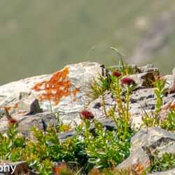
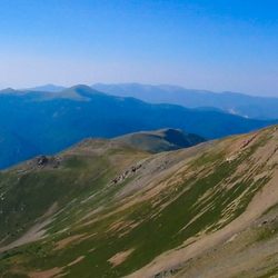
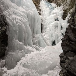
Cancel

    Open app

    Search

    Culebra Peak

    5.0 (1 review)

    Culebra Peak Photos

    Recommended Reviews - Culebra Peak

    Your trust is our priority, so businesses can't pay to alter or remove their reviews. Learn more about reviews.
    Yelp app icon
    Browse more easily on the app
    Review Feed Illustration

    2 years ago

    Helpful 1
    Thanks 0
    Love this 0
    Oh no 0

    Verify this business for free

    Get access to customer & competitor insights.

    Verify this business

    Wheeler Peak - Marmot on the trail.

    Wheeler Peak

    4.7(7 reviews)
    71.6 km

    Unless you're traversing the Continental Divide Trail, this is the ultimate in New Mexico popular…read morehiking. The 16 mile roundtrip takes you in a looping ascent from Taos Ski Valley to the summit and back. Having spent plenty of time on 14ers, I've crossed paths with my share of marmots. This tip top rock had more than I've ever seen, perhaps 50 along the way. Of course, the views are majestic. While not a 14er, New Mexico does not offer any, at 13,167' it is still an exquisite outing. This state high point is a must for anyone on the 50 state quest. If you're looking for your share of 14ers, dear western traveler, you need not worry. Colorado boasts 58 of the nation's soaring peaks and is just a short trip away. Call it 53 14ers, if you're an alpine purist.

    I spent a summer in the New Mexico high country years ago, and while I did my fair share of hiking…read morethat summer, I never took on Wheeler Peak, the highest point in New Mexico at just over 13,100 feet. I always figured I'd return to the area at some point, and maybe do the hike. Well, "some point" finally arrived, and I decided that I was going to make a serious effort at hiking this rather daunting-looking rocky, steep mountain. I gave myself permission to fail - while over the years I've probably spent far more time at altitude than 99.9% of South Floridians, the fact remains that I have spent most of my life at oxygen-rich sea level. I didn't practice for this. My existing fitness would either allow me to make it, or fail me. There are two main ways to get up the mountain, a longer, less steep 8 mile trail, and a shorter but steeper trail at just over 4 miles, known as the Williams Lake trail. I chose Williams Lake. The trailhead starts near the famous Bavarian restaurant within the Taos ski area. You basically take the road to the ski area, drive past it and find a dirt road. 2 miles up this dirt road and you'll find the trailhead parking lot. You can't miss it. I started my hike around 7:45AM. It is highly recommended to start early, as the weather above tree line is unpredictable and can change on a dime. You do NOT want to be stuck up there as an afternoon thunderstorm builds up in a matter of minutes. It is an exposed high alpine summit, subject to all the same potential extreme weather conditions of most high exposed summits. To me this hike can be broken down into 3 sections: 1) base at the Bavarian restaurant through the woods up to Williams Lake, about 2 miles, 2) Williams Lake up through ever sparser trees to tree line, about three-quarters of a mile, and 3) tree line to summit, traversing several rocky scree/talus slopes on the way, about a mile and a half. The first section up to Williams Lake is a nice hike in itself, and a popular day hike for families. It is a steady climb and not easy, and will be a challenge to inexperienced hikers, but most should be able to make it if they persevere. The payoff is a pretty high alpine lake situated in a picturesque bowl at about 11,000 feet with higher peaks on all sides. From there, part 2 gets you through sparse trees up to tree line. While not much more difficult than the first part, it was here when it became pretty apparent that every step was taking me to less oxygen. I was still strong at this point, but when you emerge in the meadows above tree line, you can see the peak and it looks way up there. In practical terms, from here you still have to climb a little higher than the Empire State Building, over the course of a mile and a half. At altitude. Above tree line. This is where it gets steeper, and rockier, as you traverse some loose talus slopes. It starts out fairly mild but ramps up fast. At this point, every step was difficult....I felt like Frodo taking the Ring to Mount Doom. It would have been very easy to quit. Some people did. It can be done though. One step at a time, keep drinking your water and you'll eventually make it. Keep an eye out for some fat marmots and bighorn sheep! Eventually you come to a staggeringly high saddle/ridgeline. From here, make a right and continue up the steep rocky slope....the payoff is only a few minutes away. Such amazing views, Wheeler Peak feels like the top of the world. What a feeling, to have walked and earned this view on the strength of your two legs. Now, after the adrenaline rush of reaching the summit, you have to descend. Pay attention. Cardio isn't a problem going down, but everything else is. Thighs burn like crazy. Lots of loose rock to slip on and hurt yourself. This was the most stunning hike I've ever done. If you think you can deal with a tough high altitude hike, I highly recommend it.

    Photos
    Wheeler Peak - Some of the wildlife along the trail.

    Some of the wildlife along the trail.

    Wheeler Peak - Panorama View from the Peak.

    Panorama View from the Peak.

    Wheeler Peak

    See all

    La Ventana Natural Arch - Archway

    La Ventana Natural Arch

    4.5(2 reviews)
    97.6 km

    During Lunch on Day 1 of my recent Earthwatch Adventure we stopped at the base of the La Ventana…read more(Window) Natural Arch. It's more of a scramble than a hike to get up to the Arch itself and it's well worth the effort, even though I hadn't yet acclimated to the altitude. The last vertical steps are also a bit tricky and left me wondering if there were a safer way down via the other side. The payoff is to experience a stunning view of the San Luis Valley and observe a hundred+ year old pinon pine. The Natural Arch was formed by the action of wind, rain and weather on a volcanic dome. This eventually carved a large hole through the rock forming a complete circle. This place really reminds me of the old Star Trek (TOS) episode called "City on the Edge of Forever". I half expected that if I jumped through the portal that I would go back in time and meet Edith Keeler. In any event, it was certainly windy enough to blow me somewhere else within the space-time continuum. Yet on the other side, was rolling green landscape and a nice place to enjoy a sack lunch. And at the end of my stay here (and unlike Mr. James Tiberius Kirk), I was in no hurry to "Get the Hell Out of Here".

    This isn't a business. It's a very beautiful natural feature from the largest volcano ever to…read morehappen, well, on earth. Go see it.

    Photos
    La Ventana Natural Arch - Person looking back through the archway

    Person looking back through the archway

    La Ventana Natural Arch - View just before reaching the Arch

    View just before reaching the Arch

    La Ventana Natural Arch - View to the other side from the arch

    See all

    View to the other side from the arch

    Culebra Peak - hiking - Updated June 2026

    Loading...
    Loading...
    Loading...