Cibecue Creek Trail Photos


You might also consider
More like Cibecue Creek Trail
Recommended Reviews - Cibecue Creek Trail
Start your review...

Reviews With Photos

The hike to the fall wasn't my absolute favorite, but the destination was well worth it! The falls are so beautiful and it's worth it just to get in the water and admire the waterfall for a little bit before heading back. You can choose to hike right up the middle in the water the entire way, or choose to hike on either the left or right side where a little bit of the trail is already paved. A few tips: wear water shoes! Your feet will get wet and it's worth it to be comfortable on your way there and back. I would park your car before the small little creek. It's possible to cross over with your car but it's just easier to find a spot before and walk the rest of the way. Make sure you go to to the RIGHT once you cross the little creek. It's confused and the signing isn't really clear and we started to walk toward the left for a few minutes before we realized we were totally going in the wrong direction. In fact, we talked to a bunch of people and they said they walked as much as three miles in the wrong direction and it took up Their whole day! Bring cash! You have to pay for your permit to be in the reservation for the day. Lastly, have fun and take lots of pictures!

One Of The Nicest Hikes In Arizona! Nice cool water weaving its way through amazing task cliffs in this beautiful canyon hidden away in a spot you would never find if not looking for it! A couple nice swimming spots to dip in and deep water with a good cliff to jump from at the waterfall! Follow the creek about 2 miles each way for around 4 miles total hike... It should take an hour to an hour and a half each way not rushing at all. This is one of the nicest hikes I have seen in the whole state of Arizona. PS: the water is a bit chilly in May but by July it should be nice! Still good for a swim now but will wake you up!

A hike to a waterfall, can't go wrong right?! Well apparently I did not read the directions online very well.. We arrived to Cibecue creek at noon, we drove down the trail in a Honda Accord which was pretty rough.. We didn't know we could drive all the way down the trail 4 miles and hike the rest of the way to the falls. We parked at campground #2 and hiked our way in hopping on the rocks in the river and swam in the river in a few spots, it was pretty sketchy! There was no turning back at that point.. We got to the end and saw 4 cars park at the big parking area. So we went to ask a guy we saw where the falls were and he directed us the way.. I was thinking how to people do this?! Swimming through river rapids and crazy deep spots. When we got to the real trail head then I realized this is a piece of cake compared to what we just did! Now we know to park down the trail 4 miles and just hike in! Which would of only been 2 miles.. It was a great hike over all, but I hate slippery rock! I have weak ankles and been hiking all week too. Apparently there are more waterfalls to explore called upper canyon.. Gear is needed and a guide from the tribe. We met someone who is in the tribe and he told us about it. Next time we will bring our climbing gear to check out the rest. Make sure to wear water shoes, we wore Keens that worked great..

Wow! Just wow. So, to begin ... the permit DOES cost $30/person which includes hiking, camping, fishing, etc in the area. I found it to be pricy but I did have a great experience and therefore worth it. I went in the summer - early July - like 106*F, brought lots of water and was totally fine doing the hike. I started the hike around 3pm and I took less than 3 hours I think - we did take our time. It's amazing how even though it's REALLY hot outside by crossing the creek through the trail cools you off perfectly. This is a gem in the dessert. Awesome waterfall!

10 years ago
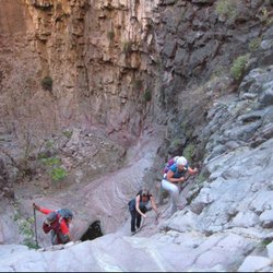
There are 2 extremes to this hike. You can choose to explore the lower canyon to a beautiful waterfall at the end surrounded by cliffs and call it a day for a total of 3 miles out and back OR you can hire a guide and canyoneer the upper canyon and spend around 5-7 hours while rappelling, climbing, and wading through endless pools and more waterfalls for a total of over 5 miles. On this adventure, my hiking group decided to take the easy route and enjoy the lower canyon. It kind of reminded me of West Fork hike in Sedona, because you cross the creek bed repeatedly, and you cannot help but stop and stare in awe of how beautiful the surroundings are. The hike is peaceful and you feel kid-like once more since you are forced to climb over small boulders, get knee deep or sometimes even waist deep in water, and brush past tree branches of various foliage. The life is teeming with so many different plant species present and with the Salt River connecting nearby, you just know the place is great for fishing as well. Permits are $15 per person for day hikes. Cibecue is on sacred land so remember to enjoy the hike in all its glory but be respectful and pack out everything you bring in. read more


One of my favorite hikes in AZ! How can you beat stunning canyon views, creek crossings, and a beautiful waterfall at the end!? Not to mention it's in the middle of nowhere away from all civilization--a great day trip getaway to relieve yourself after a stressful workweek! A few things to note before trekking out here: -You're going to want to be driving a 4x4 or high clearance vehicle as the road from the 60 turnoff is nothing but dirt and rocks. I've seen a Prius do it but it looked painful and damaging lol. -Permits are now $30 per person and you pay with cash into a box so come prepared. I'm not a huge fan of the price hike *no pun intended* but I can see why the reservation did it reduces the crowd. -Bring sturdy water shoes or prepare to get your hiking shoes wet/muddy. I have some pretty flimsy Walmart water shoes so I opted for the latter. There are multiple creek crossings and it's not like Seven Falls or Oak Creek--there are not enough stones to hop across and you will need to walk in the water.By the end of the day, my hiking shoes were completely soaked with muddy water. They will need some deep cleaning. -Piggy-backing off the point above, if you go following a monsoon storm, expect the creek and falls to be saturated with thick mud. Grand Falls style. -PLEASE pack in what you pack out. Do not litter or leave anything behind in this beautiful place. read more


9 years ago
One of the best hikes I've ever been on. It's so beautiful and tranquil. If you want to go to the Falls the fastest take the trail the entire way. But my friends and I went through the creek which proved to be challenging at parts but it was exhilarating. Well worth the $30 per person. Important things for people to know -if you don't have a 4x4 BE CAREFUL!!! I drove my Kia Forte sedan through the unpaved road and it was bumpy for the most part and I parked at campground #2 so we could just walk to the trail. But once we got back I realized that a rock punctured my gas tank . BE CAREFUL -You will get wet -Whatever you bring in bring out, I saw some trash at places -It gets slippery in places but take it slow and enjoy the beauty of Cibecue Falls read more


The hike to the fall wasn't my absolute favorite, but the destination was well worth it! The falls are so beautiful and it's worth it just to get in the water and admire the waterfall for a little bit before heading back. You can choose to hike right up the middle in the water the entire way, or choose to hike on either the left or right side where a little bit of the trail is already paved. A few tips: wear water shoes! Your feet will get wet and it's worth it to be comfortable on your way there and back. I would park your car before the small little creek. It's possible to cross over with your car but it's just easier to find a spot before and walk the rest of the way. Make sure you go to to the RIGHT once you cross the little creek. It's confused and the signing isn't really clear and we started to walk toward the left for a few minutes before we realized we were totally going in the wrong direction. In fact, we talked to a bunch of people and they said they walked as much as three miles in the wrong direction and it took up Their whole day! Bring cash! You have to pay for your permit to be in the reservation for the day. Lastly, have fun and take lots of pictures! read more


10 years ago
One Of The Nicest Hikes In Arizona! Nice cool water weaving its way through amazing task cliffs in this beautiful canyon hidden away in a spot you would never find if not looking for it! A couple nice swimming spots to dip in and deep water with a good cliff to jump from at the waterfall! Follow the creek about 2 miles each way for around 4 miles total hike... It should take an hour to an hour and a half each way not rushing at all. This is one of the nicest hikes I have seen in the whole state of Arizona. PS: the water is a bit chilly in May but by July it should be nice! Still good for a swim now but will wake you up! read more


A hike to a waterfall, can't go wrong right?! Well apparently I did not read the directions online very well.. We arrived to Cibecue creek at noon, we drove down the trail in a Honda Accord which was pretty rough.. We didn't know we could drive all the way down the trail 4 miles and hike the rest of the way to the falls. We parked at campground #2 and hiked our way in hopping on the rocks in the river and swam in the river in a few spots, it was pretty sketchy! There was no turning back at that point.. We got to the end and saw 4 cars park at the big parking area. So we went to ask a guy we saw where the falls were and he directed us the way.. I was thinking how to people do this?! Swimming through river rapids and crazy deep spots. When we got to the real trail head then I realized this is a piece of cake compared to what we just did! Now we know to park down the trail 4 miles and just hike in! Which would of only been 2 miles.. It was a great hike over all, but I hate slippery rock! I have weak ankles and been hiking all week too. Apparently there are more waterfalls to explore called upper canyon.. Gear is needed and a guide from the tribe. We met someone who is in the tribe and he told us about it. Next time we will bring our climbing gear to check out the rest. Make sure to wear water shoes, we wore Keens that worked great.. read more


9 years ago
9 years ago
Wow! Just wow. So, to begin ... the permit DOES cost $30/person which includes hiking, camping, fishing, etc in the area. I found it to be pricy but I did have a great experience and therefore worth it. I went in the summer - early July - like 106*F, brought lots of water and was totally fine doing the hike. I started the hike around 3pm and I took less than 3 hours I think - we did take our time. It's amazing how even though it's REALLY hot outside by crossing the creek through the trail cools you off perfectly. This is a gem in the dessert. Awesome waterfall! read more

9 years ago
My new favorite trail!!! I'm visiting AZ and since I'm a waterfall chaser, I had to do this one. When we first got there before driving down to the creek there's this brown Ramada looking thing. That's where you pay the $15 for your permit. Some ppl missed it and had to make the drive back up when ranger asked for it. You fill out the paper and drop the $ in the box. I don't know how they verify you actually paid though? I didn't run into a ranger luckilly cause we left permit in the dash of our vehicle not realizing we had to carry it on us because we didn't read! However, people were telling us rangers were stopping them for permits. So buy your permit! The road down was very bumpy and narrow. Hard to fit vehicles in both directions. You can park before the creek if you do not have 4 wheel drive or you can cross the creek with vehicle and many park there. Regardless where you park kust know you WILL be crossing creeks. It's unavoidable. So wear water shoes. The trail is weird. You are on one, then it ends. You have no choice but to cross creek to get back on a trail. Then that will end again and so you have to cross the creek again. It's a zig zag! I can't even count how many times we crossed. You will be climbing some bolder rocks. It's not too hard. Just make sure your shoes have grip. The waterfall area is absolutely stunning and worth it! The water gets deep and of course freezing where deep. Someone brought a raft- wish we thought of that! I'd consider this a moderate hike. No real incline. I think about 4 miles. We were there 1pm-5pm but that included play time. Absolutely NO cell service. So tell anyone that would worry about you that you will be unreachable for many hours . I lost service an hour before we got there. read more


8 years ago
9 years ago
10 years ago
10 years ago
10 years ago
More info about Cibecue Creek Trail
Cibecue, AZ 85911
Directions
Hours
Outdoor Amenities