Chiricahua National Monument Photos


More like Chiricahua National Monument
Recommended Reviews - Chiricahua National Monument
Start your review...

Reviews With Photos

Definitely a local hidden treasure. I can't believe I have lived in this area 25+ years and never visited. Don't let this be you. It's totally a car trip. Take some time to explore the visitors center and get a slight education before you venture out. Take lots of pictures and only leave some footprints on a trail. We are fortunate to have this in our backyard.

Stunning National Park of hoodoos and balancing rocks, reminded me of a mini Bryce Canyon. We enjoyed it here, you can drive to the end, hike, camp, and there's a visitor center and gift shop with park rangers who were very nice and helpful. We got a map from them and drove to Massai Point which was beautiful, the drive and the view point.
Great day trip! We had a wonderful day at the Chiricahua National Monument. I was able to take lots of pics. My husband prepared our little lunch when we got to the top and our dogs had so much fun during this trip. Overall this was a very lovely trip!! The drive from Tucson was about 2 hours and the park was not very busy on this Saturday. Wonderful place to see!

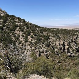
This is my favorite national monument by far! It's truly otherworldly - I've never seen anything like it. In some ways, it's even more impressive than the Grand Canyon. It's also AZ's best kept secret which means no crowds. It is more primitive than a national park. There is running water at the visitor center and a handful of snacks. However, no real food or drink available. It's about 30 miles to the nearest restaurant - so it's a bring your own food and water type of trip. There is virtually no cell reception in our surrounding the monument. This means that you need to know directions to get there and for leaving as you will not have reception to map your way in/out for a few miles. We hiked the Echo Canyon Loop. This hike is appropriately rated moderate and is 3.2 miles with a 557ft gain. Going counter clockwise is a must. You hike steeply into the canyon through the hoodoos and grottos. It feels like an alien planet. Once you've reached the bottom, the ascent is not as steep. It takes most people 1.5 hours, but we took our time and completed it in 2 hours and 45 minutes. This is my new favorite hike and I can't wait to go back!!

National Parks and Monuments invariably garner five stars from me. Chiricahua is no exception. - Wonderful park full of hoodoos. Very cool. - Nice visitor center. - If you're not able to hike, there's a good road taking you to the top where you'll be afforded great views of the park and surrounding area.

Chiricahua National Monument is a hidden gem as it is absolutely gorgeous, but didn't seem to have many visitors. Essentially, there was a volcanic eruption and with time and erosion, there are many cool-looking natural rock spires and formations. The Echo Canyon Loop (3.2mi) allows you to get up close and personal with the spires. It took us 1.5 hrs to hike this. If you go counter-clockwise you see the spires first, and then go to the less scenic area at the end to the parking lot. There was a fair amount of shade, but make sure to bring water! Massai Point Overlook is an area that you can drive to, park, and look around without much hiking needed. There is a small trail to an elevated area and covered shelter with some exhibits, but the view from the parking lot is plenty. The visitor center gives more information about the natural features of the area as well as the fauna and flora.


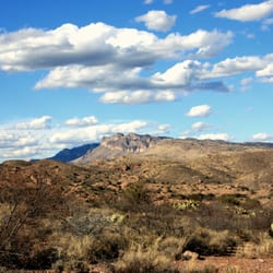
I can't believe this place exists in Arizona. What a cool hidden gem! Chiricahua National Monument is located around 30 miles southeast of Willcox. The whole area is a result of a volcanic eruption that happened millions of years ago. Chiricahua is known for its many stone columns called hoodoos. A hoodoo is a tall, thin spire of rock formed by erosion. These are the same rock formations that you see in Bryce Canyon Park in Utah. Once you enter the monument and pass the visitor center, the main road is about an 8 mile drive and ends at Massai Point. Along this scenic drive are many pullouts you can stop at and a number of hiking trails. I highly suggest grabbing a paper map at the visitor center as there is hardly any Wi-Fi in the area. I also suggest driving all the way to Massai Point. The views are amazing and worth the drive over. If you want to camp, Bonita Canyon Campground is near the entrance. It has 25 sites. For hiking, there are some easy nature trails near the visitor center. I did the Echo Canyon Trailhead at Massai Point. The hike itself is easy to moderate and the views are incredible. If you want to do more longer and difficult hikes, the Ed Riggs / Mushroom Rock / Balanced Rock trails to either Inspiration Point or Heart of Rocks is a good one. Or do Lower Rhyolite Canyon / Sarah Deming trails to Heart of Rocks from the visitor center. Both will get you deep into the canyon and close to some cool rock formations. A bill was just recently passed to make Chiricahua Arizona's fourth National Park.


Arizona's best kept secret! Came here on a Monday morning. Hiked for 5 1/2 hours and only saw 3 other people the whole time. This place has stunning views, lots of wildlife, and is very peaceful. We started at the echo canyon parking, went down Ed Riggs trail to mushroom rock trail, inspiration point, big balanced rock, heart of loops and then back the same way to the car. The entire hike was about 8 miles. There are bathrooms at the trailheads throughout the park. The trails are well maintained and obvious where the trail is. The trails are also well marked although I don't think the miles listed on them are super accurate (unless my phone isn't). A little out of the way, but definitely worth the drive!

I arrived early in the morning and there was no one there. It was a quiet drive to the end of the curvy road that takes you to the top of Chiricahua for a dramatic view of the organ pipe rock formations. At this time of year, turkey vultures fly in groups overhead looking down for the next meal. Fortunately, Chiricahua still doesn't seem to have been ruined by Instagram crowds. I'm sure it's just a matter of time. For now, enjoy.
One of my favorite places to hike. Breath taking views at every corner. Enter a world that could be used as a back drop for a Starwars film with all the amazing Hoodoos and rock formations. We hiked 9 miles including the Heart of rocks Trail. Make sure to do the short loop at the top which takes you through the hoodoos. Recommend walking poles, extra water on this hike. Also it does reach elevations of more than 7000 feet with a number of steps up and down. We drove in from Tucson and well worth the drive.

Fee free park! Beautiful scenic drive, reminiscent of Bryce Canyon and the red hoodoos they have there. I'm insane and did the Big Loop (~13.5 miles, ~4.5hrs). Also camped at Bonita Campground. When I visited, they have a shuttle on Saturdays and Sundays (~9am departure) to so you can do a point to point (one way) decline hike back to your car. Rangers very friendly! read more


I've been here twice and each time I have visited, it is mesmerizing and I don't want to leave! This place is famous for their hoodoos and amazing rock formations that will leave you speechless and in awe! And while this place is a national monument, one thing our government could do instead of all the other nonsense going on is to upgrade this place to a national park. We stopped in here after spending time at Kartchner Caverns and today the scenic drive beyond the campground was closed because of the rain and snow that came down steadily last night. And because of this and due to the amount of time we had, we did a shorter walk along the Silver Spur Meadow. This trail is very easy, well shaded and what a beautiful place to view birds! I think may have seen 15 or more species in just the short walk we did here today. I was also here about 2 years ago and did the Echo Canyon Trail to the Grotto and that was such a lovely easy hike with all sorts of cool rock formations and I enjoyed climbing around. Id like to come back and do a more strenuous hike and when I get a chance, will come back and do the Heart of the Rocks trail! Visitor center is very cool with a really nice gift shop, museum, bathrooms and very informative rangers. Parking lot can be a bit tight but more parking available down the road. I was able to get a fun stuffed sandhill crane! I could spend a lot more time here and just love this place! Great place to get a dose of nature and love how the air feels at close to 5500 feet! read more


Hidden gem. Way in the southeast corner of Arizona, south of Wilcox, we dropped in to the secluded national monument, a mountain island, in a desert ocean. We dropped by the visitor center and the kids were able to work with NP Volunteer Eric V., who was amazing. Eric was enthusiastic, and such a motivator with the kiddos. He swore in the Ruiz kids with their Chiricahua Junior Ranger badges, and helped us with a late afternoon idea to get the most out of the park. We drove up to Massai Point and enjoyed the drive up looking at roadside views of rock formations, like Sea Captain and Organ Pipes. When we got to the top, the kids were excited about the leftover snow...yes, snow. We got out to walk around the top of Massai Point and the Nature Trail. The top of Massai allows for a good panoramic view of the park and it's peaks. After a good 20minutes of awesome views we dropped into Echo Valley to see some of the rock formations up close. It's crazy how through millions of years of erosion left the hillsides full of balanced rocks, mushroom rock formations, and trails to see all of them up close. Literally, a playground of rocks in the mountains. Being in the mountains even at this elevation is different than the surrounding flats below. Temperature is different, flora, and fauna...all distinct up in the Chiricahua. Another cool thing is that the monument is the 104th dark skies destination. When it's dark, you can see stars for days. Stars the limit here. Looking forward to the next visit...and maybe an overnight stay. read more


Definitely a local hidden treasure. I can't believe I have lived in this area 25+ years and never visited. Don't let this be you. It's totally a car trip. Take some time to explore the visitors center and get a slight education before you venture out. Take lots of pictures and only leave some footprints on a trail. We are fortunate to have this in our backyard. read more


10 months ago
Stunning National Park of hoodoos and balancing rocks, reminded me of a mini Bryce Canyon. We enjoyed it here, you can drive to the end, hike, camp, and there's a visitor center and gift shop with park rangers who were very nice and helpful. We got a map from them and drove to Massai Point which was beautiful, the drive and the view point. read more


Great day trip! We had a wonderful day at the Chiricahua National Monument. I was able to take lots of pics. My husband prepared our little lunch when we got to the top and our dogs had so much fun during this trip. Overall this was a very lovely trip!! The drive from Tucson was about 2 hours and the park was not very busy on this Saturday. Wonderful place to see! read more


2 years ago
This is my favorite national monument by far! It's truly otherworldly - I've never seen anything like it. In some ways, it's even more impressive than the Grand Canyon. It's also AZ's best kept secret which means no crowds. It is more primitive than a national park. There is running water at the visitor center and a handful of snacks. However, no real food or drink available. It's about 30 miles to the nearest restaurant - so it's a bring your own food and water type of trip. There is virtually no cell reception in our surrounding the monument. This means that you need to know directions to get there and for leaving as you will not have reception to map your way in/out for a few miles. We hiked the Echo Canyon Loop. This hike is appropriately rated moderate and is 3.2 miles with a 557ft gain. Going counter clockwise is a must. You hike steeply into the canyon through the hoodoos and grottos. It feels like an alien planet. Once you've reached the bottom, the ascent is not as steep. It takes most people 1.5 hours, but we took our time and completed it in 2 hours and 45 minutes. This is my new favorite hike and I can't wait to go back!! read more


National Parks and Monuments invariably garner five stars from me. Chiricahua is no exception. - Wonderful park full of hoodoos. Very cool. - Nice visitor center. - If you're not able to hike, there's a good road taking you to the top where you'll be afforded great views of the park and surrounding area. read more


Chiricahua National Monument is a hidden gem as it is absolutely gorgeous, but didn't seem to have many visitors. Essentially, there was a volcanic eruption and with time and erosion, there are many cool-looking natural rock spires and formations. The Echo Canyon Loop (3.2mi) allows you to get up close and personal with the spires. It took us 1.5 hrs to hike this. If you go counter-clockwise you see the spires first, and then go to the less scenic area at the end to the parking lot. There was a fair amount of shade, but make sure to bring water! Massai Point Overlook is an area that you can drive to, park, and look around without much hiking needed. There is a small trail to an elevated area and covered shelter with some exhibits, but the view from the parking lot is plenty. The visitor center gives more information about the natural features of the area as well as the fauna and flora. read more


This review is for Echo Canyon Loop which was a ~3.2 miles round trip that took ~2 hours to complete. Extremely cold and windy! Rocky with some inclines. Stunning rock formations from beginning to end! Short video of the hike for those interested! https://youtu.be/EwHjPu2PLpw read more


1 year ago
Amazing hidden gem in Arizona! Lots of great hikes to choose from. The weather in the Southwest is fantastic at this national monument. read more


I can't believe this place exists in Arizona. What a cool hidden gem! Chiricahua National Monument is located around 30 miles southeast of Willcox. The whole area is a result of a volcanic eruption that happened millions of years ago. Chiricahua is known for its many stone columns called hoodoos. A hoodoo is a tall, thin spire of rock formed by erosion. These are the same rock formations that you see in Bryce Canyon Park in Utah. Once you enter the monument and pass the visitor center, the main road is about an 8 mile drive and ends at Massai Point. Along this scenic drive are many pullouts you can stop at and a number of hiking trails. I highly suggest grabbing a paper map at the visitor center as there is hardly any Wi-Fi in the area. I also suggest driving all the way to Massai Point. The views are amazing and worth the drive over. If you want to camp, Bonita Canyon Campground is near the entrance. It has 25 sites. For hiking, there are some easy nature trails near the visitor center. I did the Echo Canyon Trailhead at Massai Point. The hike itself is easy to moderate and the views are incredible. If you want to do more longer and difficult hikes, the Ed Riggs / Mushroom Rock / Balanced Rock trails to either Inspiration Point or Heart of Rocks is a good one. Or do Lower Rhyolite Canyon / Sarah Deming trails to Heart of Rocks from the visitor center. Both will get you deep into the canyon and close to some cool rock formations. A bill was just recently passed to make Chiricahua Arizona's fourth National Park. read more


This is one of my favorite places in the world. The sights are breathtaking. The hiking is fantastic. If you get a chance, ride the bus to the top and hike back down to the visitor center. The best thing about Chiricahua is that there are no crowds. The staff is super friendly too. read more


Arizona's best kept secret! Came here on a Monday morning. Hiked for 5 1/2 hours and only saw 3 other people the whole time. This place has stunning views, lots of wildlife, and is very peaceful. We started at the echo canyon parking, went down Ed Riggs trail to mushroom rock trail, inspiration point, big balanced rock, heart of loops and then back the same way to the car. The entire hike was about 8 miles. There are bathrooms at the trailheads throughout the park. The trails are well maintained and obvious where the trail is. The trails are also well marked although I don't think the miles listed on them are super accurate (unless my phone isn't). A little out of the way, but definitely worth the drive! read more


I arrived early in the morning and there was no one there. It was a quiet drive to the end of the curvy road that takes you to the top of Chiricahua for a dramatic view of the organ pipe rock formations. At this time of year, turkey vultures fly in groups overhead looking down for the next meal. Fortunately, Chiricahua still doesn't seem to have been ruined by Instagram crowds. I'm sure it's just a matter of time. For now, enjoy. read more


One of my favorite places to hike. Breath taking views at every corner. Enter a world that could be used as a back drop for a Starwars film with all the amazing Hoodoos and rock formations. We hiked 9 miles including the Heart of rocks Trail. Make sure to do the short loop at the top which takes you through the hoodoos. Recommend walking poles, extra water on this hike. Also it does reach elevations of more than 7000 feet with a number of steps up and down. We drove in from Tucson and well worth the drive. read more


4 years ago
This is a must see if you're in the Tucson area. It's definitely worth the drive! The rock formations can only be described as other worldly. Was very impressed with the well marked hiking trails. Also enjoyed that the trails weren't packed, even on a weekend. Would definitely recommend going in either the spring or the fall because I imagine it gets really hot in the summertime. Mid March was perfect! read more


We love this monument! There are so many hiking trails for all levels. The views are incredible!! There is a wonderful visitors center and so many points of interest! We love coming here and highly recommend it to all of our friends!! read more

This place has the coolest natural rock formations I've ever seen in person. I took the echo canyon loop that was about three and a half miles. Unfortunately, I only had the afternoon and couldn't stay longer, but this place has tons of trails that I would imagine are just as cool Remember to bring some sunscreen, some water, and a camera for all the great views. You know that it's going to be your new profile pic! I also wouldn't expect to make any personal time records hiking here since you spend so much time looking around in awe. I would definitely plan on my next trip here for 2 days at a minimum and look into camping and the organ pipe trails. read more


3 years ago
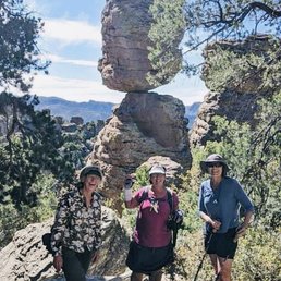
You've seen the photos. You've wondered how the heck that balancing rock stays balanced. You've noticed how far away it is from civilization... If that's not enough to convince you to head out to Chiricahua, I don't know what is. Being able to witness it firsthand will leave you absolutely awestruck! I did the Heart of Rocks loop hike, a fairly easy 7-mi roundtrip hike that takes you up to the amazing rock formations and provides plenty of opportunities for some great photos. There are so many smaller boulders on which you can climb and get some excellent shots of the scenery. Just be careful getting up/down and don't try something unless you know you can handle it! Overall, give yourself about 5 hours to complete this hike. You may be laughing now, but after stopping for snacks/photos multiple spots along the way, you'll see the time easily adds up. Get out into nature and explore the land where the laws of physics rarely apply! read more


2 years ago
This is one impressive beautiful park. We hiked the Echo canyon, the Hailstone and the Ed Riggs trails today. The Rhyolite stone formations are like none I've ever seen and it's certainly work taking the time to hike about and see them. The Rhyolite stone is from volcanic activity millions of years ago then carved over time by weathering. Not only will I be back, we plan to do more hiking here tomorrow. read more


What a beautiful hidden jewel! Spectacular scenery and views. When you first drive in at bottom of canyon there are pretty trees and close magnificent rock formations called Organ Pipe and Sea Captain. Continue on and up the mountain for a few more miles and see the unbelievable sights of Gods art at Sugar Loaf and Maasai Point! read more


9 years ago
Where have I been my entire life? How have I lived in the neighboring state to the north, known plenty of Arizona citizens, been a huge fan of the National Park System, and never once before this trip heard of Chiricahua? I'm supposed to be an outdoorsy kind of guy. I'm supposed to know this stuff. Yet there I was, in a restaurant, and the waiter was telling us we should go there. And then after hearing the name, the next day I learn that it's actually a national monument. I can only say that it's an embarrassment that it took this long to discover it. On the other hand, though, I can very honestly say that I had no expectations going in. I mean, I had no idea what it was known for. It could have been a volcano, an arch, cave, or giant hole in the ground, and I would have been equally surprised. So what is it known for and why is it a national monument? Best I tell you through story: I had just spent the night in Organ Pipe Cactus National Monument and decided, upon the advice of that friendly waiter, to check out Chiricahua next. Our day had gotten away from us a little and we rolled into Willcox a little after dark. We made the turn south on the 186 in total darkness, the kind that fires up your imagination with what might be outside of either window. Canyon walls? Flat fields of cactus? Too dark to know. We followed the signs and turned up the road into the monument, entered the trees, found the campground, turned in, and shined headlights on our site while we set up tents. We knew there were trees, we knew it smelled damper than the dry desert, and we slept. In the morning, I was last to wake up. I heard excited noises and an invitation to get out of my tent and see the "Bryce Canyon" like place. I put on my shoes, wiggled out of the tent, and had to adjust my eyes. Indeed, we were covered in trees, but through them the morning sun had set the canyon wall ablaze with color. Rock pillars and sheer canyon sheets plunged down and disappeared into the treeline. After the kind staff at the visitor's center gave us all the hiking info and maps we'd need, we drove the rest of the way into the park, climbing to the tippy top of the Massai Point Overlook. And there's why you see what this place is all about and why it's a national monument. It's a massive canyon of rocks; a series of walls with foothill hoodoos and rock formations, like little gray, green, and orange soldiers lined up amongst the trees. It had been raining, so the lichen was vibrant and the colors deep and contours in high contrast. The big, white, puffy clouds were pushed by a pleasant but brisk breeze. It's a garden of rock gnomes, some several stories high. Skinny spires and squatty blocks that excite the imagination and beg to be explored. We set off from Massai Point, down the Ed Riggs Trail, then at the sign, hit the switchback down to the river on the Mushroom Rock Trail. The namesake formation is well-marked. From there, we continued into Hunt Canyon and finally started to ascend. We skipped the Inspiration Point spur, but continued on the Big Balance Rock Trail towards the Heart Of Rocks Loop. About the time you get to Big Balanced Rock, your head is going to explode. You've just walked along a lovely forest stream, then risen to an exposed landscape with amazing views, and then entered the rock wonderland. The loop has lots of named formations, but the most breathtaking part for me was the northwestern corner where the view opens up to a whole other section (Hailstone/Echo Canyon Trails, a separate trailhead) and you see just how vast an area the formations span. I could go on about the hike, for sure. The campground is an instant classic. Clean restrooms, safe boxes for your food, ample water sources, and inexpensive. Each site has a BBQ stand, picnic table, a pad with enough room for a few small tents, or one large one. It's covered with shade, which probably comes in mighty handy in summer. Sites can be reserved ahead of time, but in our mid-week, offseason trip there were plenty of openings for walkup. Watch out for Mexican Jays; their natural tendency to scavenge for pickings from predators has morphed into an army that appears when wrappers start crinkling. And there are skunks. We saw them. It's a special place. It merits more exploration. And if you're touring around Arizona, it's unlike anything else. It's not Saguaro, it's not the Grand Canyon, it's not Organ Pipe. It's a unique, beautiful, magic place. I may not have heard of it before, but surely now I'll never be able to forget it. read more


Rock wonderland! Chiricahua national monument is a part of national park service but not admission fees, free to enter! They have several different trails, perfect for different fitness level. I did Echo Canyon trail on the day I visited. It was about 2-3 hours, just perfect as a first time visitor. I carried just two bottles of small water, one energy bar, that was enough for three hours of nice trail walk. There are a lot of photo opps along the way, I took time taking pictures and enjoyed the amazing rock formations. I would love to come back when I am more prepared and go check out the balancing rock. It would be about 6-7 hours of hike, but from a picture I saw, this place will go on my bucket list. Staff at the visitor center was very friendly, kindly took time to explain about different trails and some view points. Nice gift shops, I purchased my magnet to add to my collection for my fridge at home. There are several view points accessible by cars, suitable for any fitness levels, highly recommend visiting this rock wonderland. Cheers to the beautiful earth! read more


A friend and I hiked the major loop around Chiricahua this past weekend. We also did the smaller loop inside the park (I think it was called the Heart of Rocks trail?), so altogether it was about 10 miles. We started at noon and finished around 6:30, taking many rests and picture breaks in between. Surprisingly, we encountered very few other people on the trail! We parked our car at Massai Point and there were quite a few people there and even a whole class on a field trip, but once we started out on the trail I would say we only encountered ten other people. It was really nice to feel so remote and alone in the wilderness. As luck would have it, we happened to hike through the grotto at sunset. It was beautiful and amazing! I only wish we had seen some wildlife. All we saw were some Mexican blue jays. I'm not in the greatest shape (max I can run is like 1.75 miles without wanting to die) and I didn't think the hike was all that difficult. The hardest bit was a half mile ascent up the canyon on the Echo Loop Trail. if you can make it up Camelback in Phoenix, you can do this hike with no problem. The camping facilities were nice and pretty much what you would expect. The campgrounds do have flushing toilets, a sink, hand dryer, and mirror in the bathroom. No complaints about anything except for some campers in nearby campsites who made a LOT of noise when they woke up at 5 am. Camping is $12/night. Park entrance fees are $5/person. If you like camping, you have to make a trip out here some time! Oh! one recommendation for a stop (which I'm not sure is entirely legal) is that on the drive into the park we passed a small cemetery on the 186 about 5-10 miles outside the park entrance. on our way home, my friend and I decided to stop in to take a look, even though it said "Private Property No Trespassing" the gate was open and we only stopped in for 5 min. anyway, it turned out to be the Riggs family cemetery (from which the Edward Riggs Trail is named). it was very cool to see Ed Riggs's tombstone and to read the inscription. read more


Wowwwww. This is known as the Wonderland of Rocks! If you live in Tucson, this national monument park is practically in your back yard. Just shy of 2 hours of driving, you hit Wilcox then go south, then boom! You see all those incredible rocks! Campsites are so nice and the bathrooms are clean AF. Go up to the Echo Canyon and go down on Massai Point trail. It's a 4 mile loop hike. You'll get to see the BEST parts in the end of the loop which are the Grottos! Be sure to bring plenty of water and lunch with you as you stop half way and take in the scenic views! The trail is easy to follow! Other friends asked me if I could take them down to see it-- I would do it over and over because this place will continue to revitalize my soul every time! read more


Stunning views! I'm not an avid hiker, so I was a little intimidated to do a 7 mile trial, Rhyolite, but I survived and it was so worthwhile! We went in mid June and it was a little rainy. The cloud coverage, patches of sunlight, light humidity and breeze made it enjoyable. The weather was perfect. It took us exactly 4 hours to do the whole trail (the ranger and signage estimates 4-7 hours) starting at the monument building. It was awesome to view the various rock formations. I liked the camel's head, Thor's hammer, and kissing rocks :) Make sure to bring plenty of water and salty snacks. read more


Beautiful park. Rob had never been here before. We hiked the Grotto trail. Fabulous! The views are amazing. Photos don't do it justice. Very well maintained trails. Kids could walk in the trails with ease. Still recommend appropriate hiking shoes. I will go back here every time I'm in the area. read more


First of all, the National Parks and National Monuments and Rangers are what makes America Great, they tell a story of a nation that fights to protect the earth and it's diversity, and they tell their millions of visitors facts (not alternative ones, actual ones - and if you haven't read the statement by their former director than you absolutely should: https://www.facebook.com/parkrangers/photos/a.453853098428.247613.92474223428/10154671974088429/?type=3&theater ) to protect us from the dangers of forgetting history. Anyway, I'm emotional today and to be honest most days about the thunderous beauty of the world and how delicate it is and how lucky we are that parks (and rangers) exist both to protect and share it. Chiricahua wasn't even on our radar. We heard about it from a waiter at an awesome brunch spot (review to come, I see you Welcome Diner!) and so after camping out in Cactus Pipe (I'll review this too!) we drove through the desert and into the night to set up camp here. We set up in the dark and had no idea what we were in for. The campground spaces are awesome, you are in green woods surrounded by cliff walls that light up in the sun. There are trees between the spacious sites and, in January anyway, it's cool and there are lots of spots to choose from. The bathrooms are clean and have running water. There are fat sarcastic "Mexican Bluejays" who come visit when you make distinctive food prep sounds, but then pretend to act all casual. There are blind skunks with puffy white tails bumbling about at night who bolt off awkwardly when they hear you. The women at the visitor center opened a few minutes early for us and laughed with us and enjoyed our eagerness. They gave us good advice on driving and hiking for the day, and wondered with us at the magical mystery green smell haunting the valley. Something about recovering from wildfires maybe. Anyway, the actual best smell ever. We did the Big Loop hike from Massai Point. When we drove up to the starting point our jaws dropped. A canyon full of insane rock structures, wildly balanced on each other, enormous but delicate, glowing with new green moss, a gold halo in the distance from the sulfur flats. Completely magic. Like the green grey soulmate of Bryce Canyon in Utah, if that makes sense... and if it does, because you've got to witness both these places, than you and I are equally blessed and I wish we could share this epic resonance with every sad, needy, greedy soul out there who needs a little perspective. read more


5 years ago
Page 1 of 2
More info about Chiricahua National Monument
12856 E Rhyolite Creek Rd
Willcox, AZ 85643
Directions
(520) 824-3560
Call Now
Visit Website
http://www.nps.gov/chir
Hours
Indoor Amenities
Outdoor Amenities
Ask the Community - Chiricahua National Monument
Any recommendations for a camp site location?
Is there a lookout platform near or by a parking lot @ Massai Point to see the hoodoo rock wonders (especially the balancing one)? Will have our 2 fur babies in the car with us is why. Otherwise, we'd do the hike. Thanks!
Yes! No hike necessary! Drive to the top and enjoy!
Are dogs allowed in the Park?
Yes, leashed and are restricted on some trails, Echo Canyon doesn't allow dogs on it but daogs are allowed and many people hike with theirs
Review Highlights - Chiricahua National Monument


Why does Yelp recommend reviews?
Chiricahua National Monument - hiking - Updated May 2026
Best of Willcox
People found Chiricahua National Monument by searching for…
Trending Searches in Willcox, AZ
Browse Articles
Browse Nearby
Browse Brands
Related Searches in Willcox, AZ
Best Fishing Locations and Guides in Willcox, Arizona
Best Parks for Parties and Events in Willcox, Arizona
Best Places for Horseback Riding in Willcox, Arizona
Best Spots for Star Gazing in Willcox, Arizona
Best Waterfalls and Swimming Holes in Willcox, Arizona
Discover Baseball Fields Around Willcox, Arizona
Discover Fun Toddler Parks in Willcox, Arizona for Your Little One
Discover Popular Bike Trails in Willcox, Arizona
Discover Top Nature Parks to Visit in Willcox, Arizona
Discover the Best Beaches in Willcox, Arizona
Discover the Best Night Hike Trails in Willcox, Arizona
Dog-Friendly Hikes With Dogs in Willcox, Arizona
Enjoy Scenic Night View Experiences in Willcox, Arizona
Enjoy Tent Camping Spots Around Willcox, Arizona
Enjoy the Best Night View Spots in Willcox, Arizona
Enjoy the Best Picnic Spots and Ideas in Willcox, Arizona
Enjoy the Best Walking Trails in Willcox, Arizona
Explore Beautiful Parks and Green Spaces in Willcox, Arizona
Explore Free Things to Do Around Willcox, Arizona
Explore Landmarks & Historical Buildings in Willcox, Arizona
Explore Nature Spots Around Willcox, Arizona
Explore Parks With Pull Up Bars in Willcox, Arizona
Explore Popular Campgrounds Near Willcox, Arizona
Explore Popular Picnic Areas Around Willcox, Arizona
Explore Popular RV Parks Around Willcox, Arizona
Explore Scenic Lakes to Visit in Willcox, Arizona
Explore Secret Spots Worth Visiting in Willcox, Arizona
Explore Top Dog Parks in Willcox, Arizona Near You
Explore Top Gyms in Willcox, Arizona Now
Family Friendly Hiking With Kids in Willcox, Arizona
Find Cozy Camping Cabins in Willcox, Arizona
Find Parks and Recreation Activities in Willcox, Arizona
Find Picnic Tables for Outdoor Fun in Willcox, Arizona
Find Top Dog Swimming Spots in Willcox, Arizona
Find Top-Rated Waterfalls in Willcox, Arizona Now
Find a Public Running Track in Willcox, Arizona
Find the Best Parks BBQ Grills in Willcox, Arizona
Find the Best Scenic View Locations in Willcox, Arizona
Find the Best Swimming Pools in Willcox, Arizona Today
Fun Indoor Activities to Try in Willcox, Arizona
Great Places to Swim in Willcox, Arizona
Have Fun at a Splash Pad in Willcox, Arizona
Hiking Trails With Waterfalls in Willcox, Arizona
Must-See Tourist Attractions Around Willcox, Arizona
Parks With Basketball Courts for Games in Willcox, Arizona
Perfect Spots to Watch Sunset in Willcox, Arizona
Picnic Areas With BBQ Pits Available in Willcox, Arizona
Plan Nature Center Visits in Willcox, Arizona