Chasm View Nature Trail Photos
 - Hiking Near Me - Crawford, Colorado")
More like Chasm View Nature Trail
Recommended Reviews - Chasm View Nature Trail
Start your review...

10 months ago
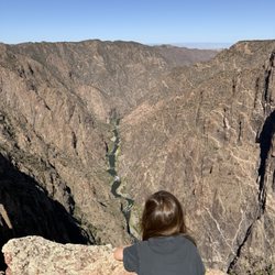
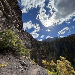
This is a nice, SUPER short walk - it's not a hike. You can circle the whole trail and be back where you started in 10 mins if you walk fast, but you should def go to the lookout point and get pics of the painted wall cause it's cool! When I went, some folks were shouting across the canyon from the other side (south rim painted wall view) and you could hear them pretty clearly - it was cool! You can also hear the rushing river from the lookout point of this trail. It's very easy and accessible for an excellent view! read more


More info about Chasm View Nature Trail
G74 Rd
Crawford, CO 81415
Directions
Hours
Outdoor Amenities


Chasm View Nature Trail - hiking - Updated July 2026
Best of Crawford
People found Chasm View Nature Trail by searching for…
Scenic Overlook in Crawford, Colorado
Hiking Trails in Crawford, Colorado
Free Things to Do in Crawford, Colorado
Easy Hikes in Crawford, Colorado
Waterfalls in Crawford, Colorado
Walking Trails in Crawford, Colorado
Canyoneering in Crawford, Colorado
Running Trails in Crawford, Colorado
Off Leash Dog Hikes in Crawford, Colorado
Scenic Views in Crawford, Colorado
Things to Do at Night in Crawford, Colorado
Outdoor Pool in Crawford, Colorado
Splash Pad in Crawford, Colorado
Dog Friendly Trails in Crawford, Colorado
Secret Spots in Crawford, Colorado
Tent Camping in Crawford, Colorado
Sunset View in Crawford, Colorado
Lookout Points in Crawford, Colorado
Browse Nearby
Browse Brands
Related Searches in Crawford, CO
Best Fishing Locations and Guides in Crawford, Colorado
Best Places for Horseback Riding in Crawford, Colorado
Explore Popular RV Parks Around Crawford, Colorado
Explore Scenic Lakes to Visit in Crawford, Colorado
Popular Kids Activities in Crawford, Colorado
Popular Things to Do in Crawford, Colorado
Browse Articles
People who viewed Chasm View Nature Trail also viewed
Tomichi Point
1 review
Dave Wood Interpretive Trail
1 review
Gunnison Gorge Wilderness
1 review
Electric Hills Trail System
2 reviews
Dave Wood Winter Recreation Area
1 review
North Rim Ranger Station
2 reviews
Divide Road Nordic Ski Trail
1 review
Buzzard Gulch Trail System
3 reviews
Homestead Ranch
1 review
Arrowhead Mountain Adventures
2 reviews