Buford Dam Photos


More like Buford Dam
Recommended Reviews - Buford Dam
Start your review...

Reviews With Photos

I love taking a ride around the Buford Dam right before sunset. It is so pretty and shows nature at its finest hour. There is plenty of areas to park around the dam. I wouldn't recommend going for a hike as there are much nicer areas to take a nice walk. The area is currently being cleaned from a previous storm so the camp sites are closed, but there are typically lots of people camping and picnicking by the waters.


A nice quiet place to go to get away for hustle and bustle. It's not too far out of the city so you can stop in any day of the week. There are picnic tables, swings, trails and benches scattered all around the lake area. I was near the dam and it still wouldn't let me check in, but I left my review none the less. Peaceful place to visit during sunset especially during fall or early spring when there aren't a lot of people around. They have a beach area also to have fun with your family. We saw ducks near the dam.

It was a nice experience to see this beautiful park/Lake Lanier when we visited Georgia. Beautiful scenic view with lots of things to do like walk in the trail, bike ride, there's a place to bank a fish, picnic tables and a beach to play in. A great spot for photo shoot. A quiet relaxing place to visit whenever you are in Georgia. Parking is only $5.00/day. Definitely recommended.


3 months ago


What would you pay to get up close and personal with a concrete and earthen structure, well five bucks per vehicle may seem reasonable, this ticket also gets you toilet privileges, bbq grills, and a picnic pavilion and some other intangibles. Dams are structures built to primarily obstruct the flow of water usually built across a stream or river constructed by man or beavers, yes there are many type of dams and in some cases provide a life-sustaining resource to people although some seem to obstruct the life of some - it's been rumored that salmon hate dams as do those that work to promote to protect the swimming right of fish. I guess one would have to weigh the pros and cons to pick a side being millions of each species are affected since humans eat fish the fish usually lose. Dams are an extremely important part of this nation's infrastructure--equal in importance to bridges, roads, airports, and other major elements of the infrastructure. They can serve several functions at once, including water supply for domestic, agricultural, industrial, and community use; flood control; recreation; and clean, renewable energy through hydropower. It's nice to know this dam has a revenue stream beside my five buck so the return on the investment is shortened. I came here at the right time on the right day - the generating stations were operating so the lower river was filled and the water was racing to its next destination so probably not the best time to float on a tube or kayak. I was somewhat surprised or maybe amused to see signage on the bank of this river that's designates the shoreline as a life-preserver zone, thankfully the government is providing this knowledge or we might have some people from the gene-pool wondering in to this massive deadly volume of rapidly flowing water, it seems the wildlife in the area understands the danger without barriers or communications. I wish I could of gotten closer to the structure so I could see the water boil from beneath the discharge of the generators but I was happy to see they do have a walk bridge a little downstream of the dam that allows you to cross over and experience the power of the release up close without a life preserver and only requires a little common sense sometimes a "danger sign" isn't needed for the obvious threat. I'm a fan of dams and understand I'm screwed if the dam burst during my visit even though I am parked in a designated paved parking lot far below the water level on the other side of this massive structure even though there is no signage inform me of this fact... read more


6 months ago
3 years ago
I love taking a ride around the Buford Dam right before sunset. It is so pretty and shows nature at its finest hour. There is plenty of areas to park around the dam. I wouldn't recommend going for a hike as there are much nicer areas to take a nice walk. The area is currently being cleaned from a previous storm so the camp sites are closed, but there are typically lots of people camping and picnicking by the waters. read more


So beautiful, so so soooo foggy . This was one of the places I'd been meaning to see for a while now. It's nothing to write home about but it's a great fishing spot and just completely beautiful to see. I believe there's also a trail that ties into this place. read more


A nice quiet place to go to get away for hustle and bustle. It's not too far out of the city so you can stop in any day of the week. There are picnic tables, swings, trails and benches scattered all around the lake area. I was near the dam and it still wouldn't let me check in, but I left my review none the less. Peaceful place to visit during sunset especially during fall or early spring when there aren't a lot of people around. They have a beach area also to have fun with your family. We saw ducks near the dam. read more


It was a nice experience to see this beautiful park/Lake Lanier when we visited Georgia. Beautiful scenic view with lots of things to do like walk in the trail, bike ride, there's a place to bank a fish, picnic tables and a beach to play in. A great spot for photo shoot. A quiet relaxing place to visit whenever you are in Georgia. Parking is only $5.00/day. Definitely recommended. read more


3 years ago
It's a very relaxing place for a small picnic, fishing and playing. The relaxing atmosphere of the river flow and calm sense makes you peaceful read more


6 years ago
This area is pretty, but has lots of near by traffic. For people accustomed to the city, the noise may not be an issue. For those suburban types, the noise may detract from the experience. There are places for fishing, hiking, and picnicking away from some of the noise. You just have to be willing to get out and walk to those areas. The park has various parking areas along the road and as of April 1st, 2018, there are credit card machines that issue parking permits. The current daily rate for parking in the area is $5 per normal, family type vehicle. read more


7 years ago
More info about Buford Dam
Ask the Community - Buford Dam
Review Highlights - Buford Dam


Why does Yelp recommend reviews?
1 review that is not currently recommended
The reviews below are not factored into the business's overall star rating.
2 years ago
Buford Dam - landmarks - Updated June 2026
Best of Buford
People found Buford Dam by searching for…
Things to Do in Buford, Georgia
Fishing Spots in Buford, Georgia
Places to Take Pictures in Buford, Georgia
Hiking Trails With Waterfalls in Buford, Georgia
Scenic View in Buford, Georgia
Scenic Drive in Buford, Georgia
Photo Spots in Buford, Georgia
Picnic Areas in Buford, Georgia
Scenic Overlook in Buford, Georgia
Walking Trails in Buford, Georgia
Fun Date Ideas in Buford, Georgia
Sunset View in Buford, Georgia
Beautiful Views in Buford, Georgia
Secret Spots in Buford, Georgia
Watch Sunset in Buford, Georgia
Picnic Spots in Buford, Georgia
Lookout Points in Buford, Georgia
Fun Things to Do at Night in Buford, Georgia
Study Spots in Buford, Georgia
Places to Study in Buford, Georgia
Trending Searches in Buford, GA
Black Owned Nail Salons near Buford Dam
Historical Sites near Buford Dam
Jet Ski Rental near Buford Dam
Landmarks & Historical Buildings near Buford Dam
Places To Visit near Buford Dam
Places To Walk Around near Buford Dam
River Swimming near Buford Dam
Scenic Restaurants near Buford Dam
Secluded Spots near Buford Dam
Strawberry Picking near Buford Dam
Swimming Holes near Buford Dam
Swimming Lakes near Buford Dam
Browse Articles
Browse Nearby
BEST of Buford, Georgia Restaurants near Buford Dam
BEST of Buford, Georgia Coffee near Buford Dam
BEST of Buford, Georgia Things to Do near Buford Dam
BEST of Buford, Georgia Parks near Buford Dam
BEST of Buford, Georgia Hiking near Buford Dam
BEST of Buford, Georgia Breakfast near Buford Dam
Browse Brands
Related Searches in Buford, GA
Best Fun Things to Do in Buford, Georgia
Best Lookout Points to Visit in Buford, Georgia
Best Places for Stunning Views in Buford, Georgia
Best Waterfalls and Swimming Holes in Buford, Georgia
Book Engaging Historical Tours in Buford, Georgia
Discover Charming Historic Homes in Buford, Georgia
Discover Historic Sites and Places in Buford, Georgia
Discover Popular Landmarks in Buford, Georgia
Discover Popular Photo Spots in Buford, Georgia
Discover Stunning Skyline View Spots in Buford, Georgia
Discover Top Nature Parks to Visit in Buford, Georgia
Discover Top State Parks to Visit in Buford, Georgia
Discover the Best Interactive Museum in Buford, Georgia
Enjoy the Best Walking Trails in Buford, Georgia
Explore Beautiful Botanical Gardens in Buford, Georgia
Explore Beautiful Castles and Landmarks in Buford, Georgia
Explore Beautiful Parks and Green Spaces in Buford, Georgia
Explore Children's Museums Near Buford, Georgia
Explore Easy Hikes Perfect for All in Buford, Georgia
Explore Free Things to Do Around Buford, Georgia
Explore Fun Field Trips in Buford, Georgia
Explore Popular Scenic Overlook Points in Buford, Georgia
Explore Popular Scenic Views Near Buford, Georgia
Explore Secret Spots Worth Visiting in Buford, Georgia
Explore Top Art Galleries Located in Buford, Georgia
Explore Top History Museums in Buford, Georgia
Explore Venues & Event Spaces in Buford, Georgia
Explore the Best Trail Options in Buford, Georgia
Find Beautiful Views in Buford, Georgia
Find Top Art Museums in Buford, Georgia
Find Top Libraries to Visit in Buford, Georgia
Find the Best Bridge Spots in Buford, Georgia
Find the Best Playgrounds to Visit in Buford, Georgia
Must-See Tourist Attractions Around Buford, Georgia
Popular Picnic Spots to Visit in Buford, Georgia
Popular Places to Go in Buford, Georgia
Popular Places to Take Pictures in Buford, Georgia
Popular Things to Do in Buford, Georgia
Popular Things to See in Buford, Georgia
Top Hiking Trails to Explore in Buford, Georgia
Top Historic Restaurants to Try in Buford, Georgia
Top Places to Visit in Buford, Georgia for Sightseeing
Top-Rated Plantation Tours Near Buford, Georgia
Tour Famous Lighthouses Located in Buford, Georgia
Tour Popular Historical Sites in Buford, Georgia
Visit Beautiful Gardens in Buford, Georgia
Visit Popular Museums in Buford, Georgia Now
Visit a Free Museum Near You in Buford, Georgia
People who viewed Buford Dam also viewed
Sawnee Mountain Preserve
106 reviews
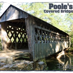
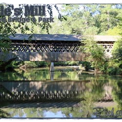
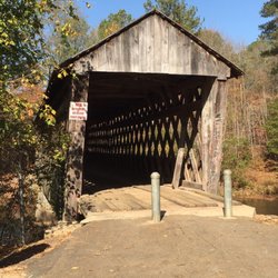
Poole's Mill Covered Bridge
6 reviews
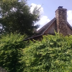
Chief White Path's Cabin
3 reviews
Mansell House & Gardens
4 reviews
Hall County Public Library
4 reviews
Gwinnett Chamber of Commerce
2 reviews
Engine 209 Park
1 review
The Roswell City Hall
3 reviews
City of Duluth- City Hall
6 reviews
Braselton Library
4 reviews