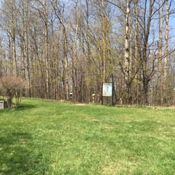
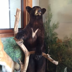
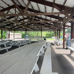
Brunet Island State Park Photos


More like Brunet Island State Park
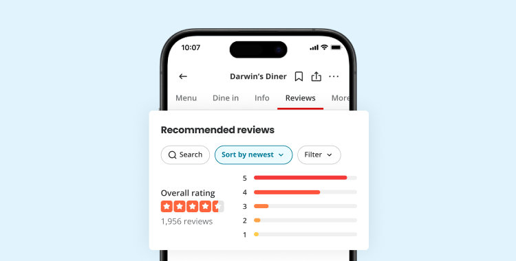
Recommended Reviews - Brunet Island State Park
Start your review...

Reviews With Photos

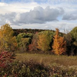
Loved, loved, loved this campsite. This despite finding out when we arrived that the showers were closed for the season and there was only a vault bathroom (aka hole in the group with no running water). The beautiful scenery and spot on the water were just perfect for fall camping. Lots of deer and squirrels on site and we enjoyed easy hiking around the island.

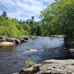
Our previous visit here was in 2003 during our tent camping days and it was a disaster. Our car broke down during an outing and we had to get it towed to Chippewa Falls for repairs. Things were much different this time and we left wondering why it took so long to return. Site 11 was the best site in the park - at the end of the loop with no neighbor on one side giving us a view of nothing but forest. The park itself is located next to a sleepy small town with no major highways nearby. Our only noise problem was our neighbor who mistook their site for a bar and stayed up drinking until 2 am. We had seen park rangers throughout the day, but there was obviously nobody on duty at night. The electrical service is 30 amp. The park has a large beach and picnic area, and canoes and kayaks are available for rent. The road that circles the island has a dedicated bike/pedestrian lane and there are plenty of trails in addition to that. There are a few geocaches in the park and dozens within 5 miles of the park. It's been a long time since we explored northwestern Wisconsin, but we have resolved to make a tour of it next year and Brunet Island will be one of our stops.

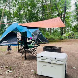
Such a cool state park! The campsites almost all have water access so you can canoe or kayak right to your site! If you don't bring canoes or kayaks, you can rent some from the park office for a minimal fee. Highly recommend exploring the island from the water. Way cool. The campsites are all pretty flat (perfect for pitching tents) and all have fire pits with good moveable cooking grates. Both nights we were there had a good breeze so the bugs were non-existent which was amazing considering we camped right next to the water. The park also has several short well-maintained trails to explore . Will definitely be returning. read more
Loved, loved, loved this campsite. This despite finding out when we arrived that the showers were closed for the season and there was only a vault bathroom (aka hole in the group with no running water). The beautiful scenery and spot on the water were just perfect for fall camping. Lots of deer and squirrels on site and we enjoyed easy hiking around the island. read more


6 years ago
Our previous visit here was in 2003 during our tent camping days and it was a disaster. Our car broke down during an outing and we had to get it towed to Chippewa Falls for repairs. Things were much different this time and we left wondering why it took so long to return. Site 11 was the best site in the park - at the end of the loop with no neighbor on one side giving us a view of nothing but forest. The park itself is located next to a sleepy small town with no major highways nearby. Our only noise problem was our neighbor who mistook their site for a bar and stayed up drinking until 2 am. We had seen park rangers throughout the day, but there was obviously nobody on duty at night. The electrical service is 30 amp. The park has a large beach and picnic area, and canoes and kayaks are available for rent. The road that circles the island has a dedicated bike/pedestrian lane and there are plenty of trails in addition to that. There are a few geocaches in the park and dozens within 5 miles of the park. It's been a long time since we explored northwestern Wisconsin, but we have resolved to make a tour of it next year and Brunet Island will be one of our stops. read more


4 years ago
15 years ago
10 years ago
We stayed at this campground July 2016. This is a very nice campground with easy access to Highway 29 across Wisconsin. It is a typical State Park campground, although slightly different in that the full hook up sites are not particularly private. Regardless, there is a play area, beach, kayak rentals and plenty of fishing opportunities. There are a number of hiking trails, as well as extensive tent sites. If you are into biking, I would suggest bringing your bikes along as there is a fairly lengthy loop around the park. There is a Boatlanding just inside the park that is quite adequate. Shower house was average. Firewood can be purchased at the host location for five dollars a bundle however, it is primarily softwoods. Many of the park trees are Maples and I would imagine would be quite beautiful in October. Definitely a must visit location and a beautiful park. read more


5 years ago
12 years ago
12 years ago
More info about Brunet Island State Park
Ask the Community - Brunet Island State Park
Review Highlights - Brunet Island State Park


Brunet Island State Park - parks - Updated August 2026
Best of Cornell
People found Brunet Island State Park by searching for…
Trending Searches in Cornell, WI
Browse Articles
Browse Nearby
Browse Brands
Related Searches in Cornell, WI
Best Fishing Locations and Guides in Cornell, Wisconsin
Best Nature Trails for Hiking in Cornell, Wisconsin
Best Water Parks for Kids in Cornell, Wisconsin
Best Waterfalls and Swimming Holes in Cornell, Wisconsin
Check Out Great Playgrounds in Cornell, Wisconsin
Check Out Off Road Trails in Cornell, Wisconsin
Discover Lakes & Ponds to Explore in Cornell, Wisconsin
Discover Popular Bike Trails in Cornell, Wisconsin
Discover Popular Photo Spots in Cornell, Wisconsin
Discover Top Nature Parks to Visit in Cornell, Wisconsin
Discover the Best Fishing Lake in Cornell, Wisconsin
Enjoy Arts & Entertainment in Cornell, Wisconsin
Enjoy Hiking Adventures in Cornell, Wisconsin
Enjoy the Best Picnic Spots and Ideas in Cornell, Wisconsin
Enjoy the Best Walking Trails in Cornell, Wisconsin
Experience Stunning Sunset Views in Cornell, Wisconsin
Explore Landmarks & Historical Buildings in Cornell, Wisconsin
Explore Picnic Parks Near Cornell, Wisconsin
Explore Popular Campgrounds Near Cornell, Wisconsin
Explore Popular Picnic Areas Around Cornell, Wisconsin
Explore Popular Scenic Views Near Cornell, Wisconsin
Explore Popular View Points Around Cornell, Wisconsin
Explore Secret Spots Worth Visiting in Cornell, Wisconsin
Explore Top Gyms in Cornell, Wisconsin Now
Explore Venues & Event Spaces in Cornell, Wisconsin
Find Beautiful Views in Cornell, Wisconsin
Find Fun Kids Activities Outdoor in Cornell, Wisconsin
Find Picnic Tables for Outdoor Fun in Cornell, Wisconsin
Find Top-Rated Waterfalls in Cornell, Wisconsin Now
Find the Best Parks for Picnics in Cornell, Wisconsin
Find the Best Playgrounds to Visit in Cornell, Wisconsin
Great Places to Swim in Cornell, Wisconsin
Must-See Tourist Attractions Around Cornell, Wisconsin
Perfect Spots to Watch Sunset in Cornell, Wisconsin
Picnic Areas With BBQ Pits Available in Cornell, Wisconsin
Popular Fishing Spots to Explore in Cornell, Wisconsin
Popular Picnic Spots to Visit in Cornell, Wisconsin
Popular Places to Take Pictures in Cornell, Wisconsin
Popular Places to Walk Around in Cornell, Wisconsin
Popular Things to Do in Cornell, Wisconsin
Popular Things to See in Cornell, Wisconsin
Safe and Fun Parks for Kids in Cornell, Wisconsin
Top Dog Friendly Things to Do in Cornell, Wisconsin
Top Hiking Trails to Explore in Cornell, Wisconsin
Top Places to Visit in Cornell, Wisconsin for Sightseeing
Top Playgrounds for Kids to Enjoy in Cornell, Wisconsin
Top Running Trails to Explore in Cornell, Wisconsin


