Boulder Canyon Trail - Superstition Mountain Photos


You might also consider
More like Boulder Canyon Trail - Superstition Mountain
Recommended Reviews - Boulder Canyon Trail - Superstition Mountain
Start your review...

Reviews With Photos

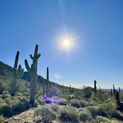
I came here to do Superstition Mountain on a Sunday, and the overflow parking lot was pretty full when I arrived. I managed to snag a spot though and started the hike around 9:50AM. Going up, we got extremely lost and had to bushwhack our way back to the right trail which was unpleasant due to all the prickly plants, but eventually we got onto the right path and got up to Superstition Mountain. The scenery from above was quite good, especially the back side facing the canyon. The hike back down was alright too although there were some parts that went slightly up. All in all a pretty good hike with views; no shade though so bring plenty of water!

My little dude and I headed up here after a night at a hotel where he decided he was going to sleep for a total of 2 hours. My better half and I took turns trying to convince him that was a bad decision and come about 5:30 it was time for mom to get a little shut eye. Enter Yelp and a search for sunrise spots! We started driving East from Mesa and about 60 minutes later and 15 miles up a very dusty, but very well kept road, my little guy and I had one of those stories that I'll remember for a long time! The road weaves up into the hills for about 10 miles and is quite a fun drive, even in a rented Chevy Impala. We came as the sun was starting to come up and it made for some great pictures of the desert and the rock wall that greets you from the parking lot of the trail head. It was actually very reminiscent of the sun rising and setting at Uluru (Ayers Rock) in Australia. We didn't go hiking, though we did look at the map which looked very impressive. Additionally, we had some guy time in the car pushing buttons, because that's what's cool to an 18 month old, so obviously I was down! Make sure to bring a coat as you're up a surprising amount at the trail head and when the sun was coming up, it was chilly. Regardless of your circumstances, this is a great place to go watch the sun come up and get away from things for a bit, without having to go too far.

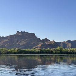
Up until recently, my only experience hiking the Supes has been up Flatiron at Lost Dutchman State Park. I knew there was more out there to explore but wasn't sure if my sedan could handle the roads. When I heard that the 88 (at least out to Tortilla Flat) was indeed paved, I planned my adventure and headed out to Boulder Canyon! The trailhead is across the street from the Canyon Lake marina area and does not require a Tonto Pass to park there! Once you hit the trail, you are met with an initial gradual uphill climb to nice views of Four Peaks, Canyon Lake, and Weaver's Needle off in the distance. If you're in the mood for a less strenuous and quick hike, this is the point where you stop, admire the scenery, and head back down. For the serious hikers, you then make a sharp descent into LaBarge Canyon. You hop over LaBarge Creek and it's cool waters and proceed onto Boulder Canyon/Creek. If you continue along this trail beyond Boulder, you apparently will reach Battleship Mountain (didn't venture that far but a few others I saw on the way were heading out to it). All in all, it's a great hike for getting out into nature with no civilization around whatsoever, and for working out all those lower body muscles! Remember, you will need them at the end to climb BACK OUT of the canyons to the vantage point described earlier in this review. A few final notes: *Bring plenty of water!!! This is a pretty lengthy hike and especially if you are hiking in warmer weather, the uphill/downhill shifts will leave you thirstier than usual. *PLEASE pack in what you pack out. Nobody wants to find trash on the trail. *You will likely find old artifacts and remnants of old adobe structures on the hike. Please leave everything as you found it to preserve for future hikers like yourself to enjoy. *Again, parking is in the lot for the marina. Swing left after going over the bridge and you'll find yourself in it. Enjoy!

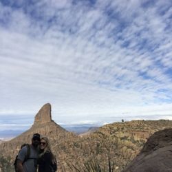
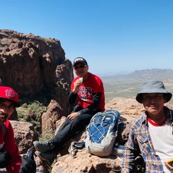
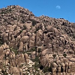
Awestruck. That is how I felt sitting on an overhang just off of the Boulder Canyon trail, taking in the most magnificent view I have seen since moving to Arizona. Enjoying the pleasant warmth of the sun and the light breeze, it was one of those rare moments where I wouldn't change, well, anything. The Boulder Canyon trail was my first venture into the Superstition Mountains/Tonto National Forest. What a great introduction! I am happy to know that something so enjoyable is less than an hour from my front door. First, the winding section of AZ88 to/from Canyon Lake Marina (parking for the trail) is an experience in itself. Definitely a take the convertible, drop the top, wind in the hair type of drive. Woo! Twists, turns, breathtaking views of the lake and rock formations, plus a couple of one-way bridges thrown in just to keep things interesting. The trail itself begins on the south side of AZ88, right across from the Marina, and immediately starts climbing into the hills. Parts of the trail are a little challenging, with loose rock and a couple of fallen saguaro to maneuver around/over, and a few areas with somewhat steep incline. Take it at your own pace, you will get there! (hint: if your friend is much faster than you and disappears into the distance, take solace in knowing you have the car keys... haha!) There is a lot to see along the way - cool rocks, huge cholla and saguaro that look like something out of a Dr. Seuss illustration. Due to the recent rain, everything was much greener than I expected too. The reward at the peak is more than worth the effort - a panoramic view of Weaver's Needle, Battleship Mountain, La Barge Canyon/creek and the Superstition ridgeline. Truly spectacular. If you haven't been here, add it to your to-do list. Now. In a couple of weeks, there should be wildflowers...

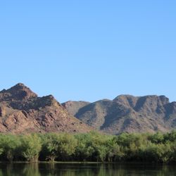
This is a beautiful trail about 60 minutes east of Tempe. The trip up the mountain is great in itself, but the trail is breathtaking. Great views of the Superstitions and Canyon lake, by far my most favorite lake. The hike is moderate I would say, and it runs 12 miles one way, although I've never done more than 3 miles in.

This review is for Boulder Canyon Trail to Boulder Canyon Viewpoint which was a ~5 miles round trip that took ~3 hours to complete. Extremely rocky with some inclines! Stunning views throughout the hike! Parking was located across the street at the Canyon Lake Marina (10 designated parking). Short video of the hike for those interested! https://youtu.be/V575RGhFAKQ read more


An amazing hike with views as of you are hiding up in the mountains. Here's the facts: 7-8 miles total round trip to first site of water Moderate to difficult trail depending if you go down into the Canyon (very steep uphill back) 30-45 mins to first overlook with stunning views 1-1.5 hours to "top" before descending down into canyon Bring tons of water and snacks AND electrolytes! Tip: I always wear gloves b/c trail is so rocky it's easy to fall and cactus are everywhere! read more


I came here to do Superstition Mountain on a Sunday, and the overflow parking lot was pretty full when I arrived. I managed to snag a spot though and started the hike around 9:50AM. Going up, we got extremely lost and had to bushwhack our way back to the right trail which was unpleasant due to all the prickly plants, but eventually we got onto the right path and got up to Superstition Mountain. The scenery from above was quite good, especially the back side facing the canyon. The hike back down was alright too although there were some parts that went slightly up. All in all a pretty good hike with views; no shade though so bring plenty of water! read more

My little dude and I headed up here after a night at a hotel where he decided he was going to sleep for a total of 2 hours. My better half and I took turns trying to convince him that was a bad decision and come about 5:30 it was time for mom to get a little shut eye. Enter Yelp and a search for sunrise spots! We started driving East from Mesa and about 60 minutes later and 15 miles up a very dusty, but very well kept road, my little guy and I had one of those stories that I'll remember for a long time! The road weaves up into the hills for about 10 miles and is quite a fun drive, even in a rented Chevy Impala. We came as the sun was starting to come up and it made for some great pictures of the desert and the rock wall that greets you from the parking lot of the trail head. It was actually very reminiscent of the sun rising and setting at Uluru (Ayers Rock) in Australia. We didn't go hiking, though we did look at the map which looked very impressive. Additionally, we had some guy time in the car pushing buttons, because that's what's cool to an 18 month old, so obviously I was down! Make sure to bring a coat as you're up a surprising amount at the trail head and when the sun was coming up, it was chilly. Regardless of your circumstances, this is a great place to go watch the sun come up and get away from things for a bit, without having to go too far. read more


Up until recently, my only experience hiking the Supes has been up Flatiron at Lost Dutchman State Park. I knew there was more out there to explore but wasn't sure if my sedan could handle the roads. When I heard that the 88 (at least out to Tortilla Flat) was indeed paved, I planned my adventure and headed out to Boulder Canyon! The trailhead is across the street from the Canyon Lake marina area and does not require a Tonto Pass to park there! Once you hit the trail, you are met with an initial gradual uphill climb to nice views of Four Peaks, Canyon Lake, and Weaver's Needle off in the distance. If you're in the mood for a less strenuous and quick hike, this is the point where you stop, admire the scenery, and head back down. For the serious hikers, you then make a sharp descent into LaBarge Canyon. You hop over LaBarge Creek and it's cool waters and proceed onto Boulder Canyon/Creek. If you continue along this trail beyond Boulder, you apparently will reach Battleship Mountain (didn't venture that far but a few others I saw on the way were heading out to it). All in all, it's a great hike for getting out into nature with no civilization around whatsoever, and for working out all those lower body muscles! Remember, you will need them at the end to climb BACK OUT of the canyons to the vantage point described earlier in this review. A few final notes: *Bring plenty of water!!! This is a pretty lengthy hike and especially if you are hiking in warmer weather, the uphill/downhill shifts will leave you thirstier than usual. *PLEASE pack in what you pack out. Nobody wants to find trash on the trail. *You will likely find old artifacts and remnants of old adobe structures on the hike. Please leave everything as you found it to preserve for future hikers like yourself to enjoy. *Again, parking is in the lot for the marina. Swing left after going over the bridge and you'll find yourself in it. Enjoy! read more


16 years ago
Awestruck. That is how I felt sitting on an overhang just off of the Boulder Canyon trail, taking in the most magnificent view I have seen since moving to Arizona. Enjoying the pleasant warmth of the sun and the light breeze, it was one of those rare moments where I wouldn't change, well, anything. The Boulder Canyon trail was my first venture into the Superstition Mountains/Tonto National Forest. What a great introduction! I am happy to know that something so enjoyable is less than an hour from my front door. First, the winding section of AZ88 to/from Canyon Lake Marina (parking for the trail) is an experience in itself. Definitely a take the convertible, drop the top, wind in the hair type of drive. Woo! Twists, turns, breathtaking views of the lake and rock formations, plus a couple of one-way bridges thrown in just to keep things interesting. The trail itself begins on the south side of AZ88, right across from the Marina, and immediately starts climbing into the hills. Parts of the trail are a little challenging, with loose rock and a couple of fallen saguaro to maneuver around/over, and a few areas with somewhat steep incline. Take it at your own pace, you will get there! (hint: if your friend is much faster than you and disappears into the distance, take solace in knowing you have the car keys... haha!) There is a lot to see along the way - cool rocks, huge cholla and saguaro that look like something out of a Dr. Seuss illustration. Due to the recent rain, everything was much greener than I expected too. The reward at the peak is more than worth the effort - a panoramic view of Weaver's Needle, Battleship Mountain, La Barge Canyon/creek and the Superstition ridgeline. Truly spectacular. If you haven't been here, add it to your to-do list. Now. In a couple of weeks, there should be wildflowers... read more


11 years ago
This is a beautiful trail about 60 minutes east of Tempe. The trip up the mountain is great in itself, but the trail is breathtaking. Great views of the Superstitions and Canyon lake, by far my most favorite lake. The hike is moderate I would say, and it runs 12 miles one way, although I've never done more than 3 miles in. read more

The five stars is not only for this trail but for the Superstition Mounntains and all her beauty. I more or less just wanted to add some photos of mine that I took on this trail. If I remember correctly, this trail is fairly easy in comparison to other trails into these mountains. I might be mistaken but from this trail you cannot see weavers needle, maybe the tip of it, but no matter there are other majestic views to observe. Like any hike you do, you will want to bring plenty of water. Enough for the entire trip cause there is no place to refill your water on this hike. Unless you have a backpacking water purifier. I did it as an overnight hike, which I believe the only way to hike the Superstitions. And unlike the other review I read, when I hiked this trail the stream flowed with water. This was also years ago and it might be a different story nowadays. This is not a hike for the family or unprepared, this is wilderness your entering and one must be careful. read more


16 years ago
14 years ago
16 years ago
13 years ago
More info about Boulder Canyon Trail - Superstition Mountain
16802 NE Hwy 88
Tortilla Flat, AZ 85219
Directions
Hours
Outdoor Amenities
Ask the Community - Boulder Canyon Trail - Superstition Mountain
Review Highlights - Boulder Canyon Trail - Superstition Mountain


Boulder Canyon Trail - Superstition Mountain - hiking - Updated May 2026
Best of Tortilla Flat
People found Boulder Canyon Trail - Superstition Mountain by searching for…
Places to Take Pictures in Tortilla Flat, Arizona
Photo Spots in Tortilla Flat, Arizona
Watch Sunset in Tortilla Flat, Arizona
Off Road Trails in Tortilla Flat, Arizona
Sunrise Hike in Tortilla Flat, Arizona
Walking Paths in Tortilla Flat, Arizona
Hiking Trails in Tortilla Flat, Arizona
Public Shower in Tortilla Flat, Arizona
Natural Hot Springs in Tortilla Flat, Arizona
Night Hike in Tortilla Flat, Arizona
Things to Do in Tortilla Flat, Arizona
Beautiful Views in Tortilla Flat, Arizona
Easy Hikes in Tortilla Flat, Arizona
Creeks in Tortilla Flat, Arizona
Scenic Overlook in Tortilla Flat, Arizona
Stroller Friendly Hikes in Tortilla Flat, Arizona
Waterfall Hike in Tortilla Flat, Arizona
Night View in Tortilla Flat, Arizona
Canyoneering in Tortilla Flat, Arizona
Cruising Spots in Tortilla Flat, Arizona
Hiking With Kids in Tortilla Flat, Arizona
Nature Parks in Tortilla Flat, Arizona
Browse Nearby
BEST of Tortilla Flat, Arizona Restaurants near Boulder Canyon Trail - Superstition Mountain
BEST of Tortilla Flat, Arizona Things to Do near Boulder Canyon Trail - Superstition Mountain
BEST of Tortilla Flat, Arizona Coffee near Boulder Canyon Trail - Superstition Mountain
BEST of Tortilla Flat, Arizona Campgrounds near Boulder Canyon Trail - Superstition Mountain
BEST of Tortilla Flat, Arizona Breakfast near Boulder Canyon Trail - Superstition Mountain
BEST of Tortilla Flat, Arizona Wineries near Boulder Canyon Trail - Superstition Mountain
BEST of Tortilla Flat, Arizona Lakes near Boulder Canyon Trail - Superstition Mountain
BEST of Tortilla Flat, Arizona Hotels near Boulder Canyon Trail - Superstition Mountain
Browse Brands
Browse Articles
People who viewed Boulder Canyon Trail - Superstition Mountain also viewed
Wave Cave
56 reviews
Wind Cave Trail
68 reviews
Hieroglyphic Trail Hoa
65 reviews
Silly Mountain Park
28 reviews
Lost Dutchman State Park
181 reviews
Spook Hill Mountain Preserve
17 reviews
Granite Reef Recreation Site
10 reviews
Fish Creek Trail 60
1 review
Siphon Draw Trail inc. Flatiron, Superstition Mountain
89 reviews
Blevins Trail
1 review