Blowing Cave Mill Photos


More like Blowing Cave Mill
Recommended Reviews - Blowing Cave Mill
Start your review...

12 days ago
Neat place! Takes you a little back in time. Nice gem to visit and buy candy, baked goods, and other odds and ends. read more


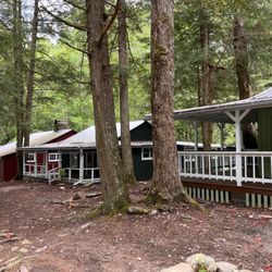
The Blowing Cave Mill is now open! They are closed on Sundays but you can stop by Monday-Saturday, 9:30am-6:00pm. They have lots of unique candies, breads, and drinks for sale. You can take a mill tour for $10 and it is well worth it (Jan was a fantastic guide). Stop by and sit on the front porch and rock your troubles away. read more

9 months ago
This place is a gem and must stop and check out. They have all sorts of different things to buy of course including candy jams,and baked goods, but the must do is the mill to with Gary. It is awesome and you will not regret it and yes it is open. read more


3 years ago
More info about Blowing Cave Mill


Blowing Cave Mill - landmarks - Updated June 2026
Best of Sevierville
People found Blowing Cave Mill by searching for…
Things to Do in Sevierville, Tennessee
Caves in Sevierville, Tennessee
Places to Take Pictures in Sevierville, Tennessee
Scenic View in Sevierville, Tennessee
Scenic Overlook in Sevierville, Tennessee
Tourist Attractions in Sevierville, Tennessee
Waterfall in Sevierville, Tennessee
Public Services & Government in Sevierville, Tennessee
Attractions in Sevierville, Tennessee
Photo Spots in Sevierville, Tennessee
Parking in Sevierville, Tennessee
Plantation Tours in Sevierville, Tennessee
Historical Tours in Sevierville, Tennessee
View Points in Sevierville, Tennessee
Field Trips in Sevierville, Tennessee
Historical Sites in Sevierville, Tennessee
Things to See in Sevierville, Tennessee
Chapel in Sevierville, Tennessee
Scenic Drive in Sevierville, Tennessee
Landmarks in Sevierville, Tennessee
Hiking Trails With Waterfalls in Sevierville, Tennessee
Stuff to Do in Sevierville, Tennessee
Trending Searches in Sevierville, TN
Boat Rental near Blowing Cave Mill
Cliff Jumping near Blowing Cave Mill
Day Trips near Blowing Cave Mill
Fishing Spots near Blowing Cave Mill
Hidden Gems near Blowing Cave Mill
Historical Sites near Blowing Cave Mill
Jet Ski Rental near Blowing Cave Mill
Kayak Rental near Blowing Cave Mill
Landmarks & Historical Buildings near Blowing Cave Mill
Lookout Points near Blowing Cave Mill
Places To Visit near Blowing Cave Mill
Public Art near Blowing Cave Mill
Public Pools near Blowing Cave Mill
River Swimming near Blowing Cave Mill
River Walk near Blowing Cave Mill
Scenic Restaurants near Blowing Cave Mill
Secluded Spots near Blowing Cave Mill
Sightseeing near Blowing Cave Mill
Soccer Store near Blowing Cave Mill
Splash Pad near Blowing Cave Mill
Strawberry Picking near Blowing Cave Mill
Swimming Holes near Blowing Cave Mill
Swimming Lakes near Blowing Cave Mill
Things To See near Blowing Cave Mill
U Pick Farms near Blowing Cave Mill
Browse Articles
Browse Nearby
BEST of Sevierville, Tennessee Restaurants near Blowing Cave Mill
BEST of Sevierville, Tennessee Coffee near Blowing Cave Mill
BEST of Sevierville, Tennessee Attractions near Blowing Cave Mill
BEST of Sevierville, Tennessee Things to Do near Blowing Cave Mill
BEST of Sevierville, Tennessee Shopping near Blowing Cave Mill
BEST of Sevierville, Tennessee Breakfast near Blowing Cave Mill
Browse Brands
Related Searches in Sevierville, TN
Best Fun Things to Do in Sevierville, Tennessee
Best Lookout Points to Visit in Sevierville, Tennessee
Best Nature Trails for Hiking in Sevierville, Tennessee
Best Waterfalls and Swimming Holes in Sevierville, Tennessee
Book Engaging Historical Tours in Sevierville, Tennessee
Discover Charming Historic Homes in Sevierville, Tennessee
Discover Famous Monuments in Sevierville, Tennessee
Discover Historic Sites and Places in Sevierville, Tennessee
Discover Popular Landmarks in Sevierville, Tennessee
Discover Popular Photo Spots in Sevierville, Tennessee
Discover Stunning Skyline View Spots in Sevierville, Tennessee
Enjoy Arts & Entertainment in Sevierville, Tennessee
Enjoy the Best Walking Trails in Sevierville, Tennessee
Explore Beautiful Botanical Gardens in Sevierville, Tennessee
Explore Beautiful Castles and Landmarks in Sevierville, Tennessee
Explore Beautiful Parks and Green Spaces in Sevierville, Tennessee
Explore Easy Hikes Perfect for All in Sevierville, Tennessee
Explore Free Things to Do Around Sevierville, Tennessee
Explore Fun Activities to Do in Sevierville, Tennessee
Explore Fun Field Trips in Sevierville, Tennessee
Explore Popular Scenic Overlook Points in Sevierville, Tennessee
Explore Popular Scenic Views Near Sevierville, Tennessee
Explore Secret Spots Worth Visiting in Sevierville, Tennessee
Explore Top Art Galleries Located in Sevierville, Tennessee
Explore Top Haunted Places Near Sevierville, Tennessee
Explore Venues & Event Spaces in Sevierville, Tennessee
Explore the Top Car Museum in Sevierville, Tennessee
Explore the Wax Museum Attractions in Sevierville, Tennessee
Find Beautiful Views in Sevierville, Tennessee
Find Exciting Tours to Take in Sevierville, Tennessee
Find Top Art Museums in Sevierville, Tennessee
Find Top Libraries to Visit in Sevierville, Tennessee
Find Top-Rated Waterfalls in Sevierville, Tennessee Now
Find Visitor Centers to Explore in Sevierville, Tennessee
Find the Best Bridge Spots in Sevierville, Tennessee
Find the Best Playgrounds to Visit in Sevierville, Tennessee
Great Things to See and Do in Sevierville, Tennessee
Must-See Tourist Attractions Around Sevierville, Tennessee
Popular Picnic Spots to Visit in Sevierville, Tennessee
Popular Places to Take Pictures in Sevierville, Tennessee
Popular Things to Do in Sevierville, Tennessee
Popular Things to See in Sevierville, Tennessee
Top Hiking Trails to Explore in Sevierville, Tennessee
Top Historic Restaurants to Try in Sevierville, Tennessee
Top Things to Do With Kids in Sevierville, Tennessee
Top-Rated Plantation Tours Near Sevierville, Tennessee
Tour Popular Historical Sites in Sevierville, Tennessee
Visit Beautiful Gardens in Sevierville, Tennessee