Black Canyon Campground Photos


You might also consider
More like Black Canyon Campground
Recommended Reviews - Black Canyon Campground
Start your review...

8 months ago
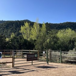
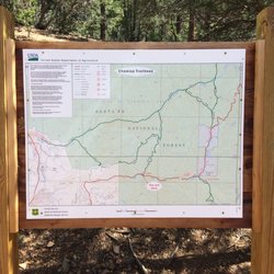
Nice hike for us fairly fit seniors is the loop trail. Park at the lodge or just before it st the campground where sign indicates black canyon trail. Walk past the lodge and look for sign with trail map. We thought we'd try the waterfall trail but no signage made us stop after crossing the stream several times and ending at a memorial cross. Someone said you need to scramble with large rock/cliff to the left and keep going. The lodge was closed when we went in mid September. Lovely cool day for a 9:00 am hike. read more


9 years ago
16 years ago
10 years ago
9 years ago
12 years ago
More info about Black Canyon Campground
Santa Fe National Forest
NM 475
Santa Fe, NM 87508
Directions
Hours
Outdoor Amenities
Ask the Community - Black Canyon Campground


Black Canyon Campground - hiking - Updated May 2026
Best of Santa Fe
People found Black Canyon Campground by searching for…
Campgrounds in Santa Fe, New Mexico
Things to Do at Night in Santa Fe, New Mexico
Hiking Trails in Santa Fe, New Mexico
Off Road Trails in Santa Fe, New Mexico
Walking Trails in Santa Fe, New Mexico
Things to Do in Santa Fe, New Mexico
Easy Hikes in Santa Fe, New Mexico
Camping Sites in Santa Fe, New Mexico
Running Trails in Santa Fe, New Mexico
Canyoneering in Santa Fe, New Mexico
Sunset View in Santa Fe, New Mexico
Camping Cabins in Santa Fe, New Mexico
Scenic Night View in Santa Fe, New Mexico
Waterfalls in Santa Fe, New Mexico
What to Do in Santa Fe, New Mexico
Off Leash Dog Hikes in Santa Fe, New Mexico
Trails in Santa Fe, New Mexico
Sunday Fun Things to Do in Santa Fe, New Mexico
Night Hike in Santa Fe, New Mexico
Trending Searches in Santa Fe, NM
Botanical Gardens near Black Canyon Campground
Bounce House Rentals near Black Canyon Campground
Dress Shops near Black Canyon Campground
Garage Sales near Black Canyon Campground
Garden Center near Black Canyon Campground
Golf Driving Range near Black Canyon Campground
Golf Lessons near Black Canyon Campground
Lakes & Ponds near Black Canyon Campground
Limos near Black Canyon Campground
Nurseries & Gardening near Black Canyon Campground
Outdoor Activities near Black Canyon Campground
Outdoor Furniture Stores near Black Canyon Campground
Parks near Black Canyon Campground
Pedicure near Black Canyon Campground
Photo Spots near Black Canyon Campground
Places To Take Pictures near Black Canyon Campground
Plant Nursery near Black Canyon Campground
Scenic Drive near Black Canyon Campground
Sunrise View near Black Canyon Campground
Swimming Holes near Black Canyon Campground
Table And Chair Rentals near Black Canyon Campground
Browse Articles
Browse Nearby
BEST of Santa Fe, New Mexico Restaurants near Black Canyon Campground
BEST of Santa Fe, New Mexico Coffee near Black Canyon Campground
BEST of Santa Fe, New Mexico Things to Do near Black Canyon Campground
BEST of Santa Fe, New Mexico Parks near Black Canyon Campground
BEST of Santa Fe, New Mexico Hotels near Black Canyon Campground
BEST of Santa Fe, New Mexico Breakfast near Black Canyon Campground
BEST of Santa Fe, New Mexico Shopping near Black Canyon Campground
Browse Brands
Related Searches in Santa Fe, NM
Best Fishing Locations and Guides in Santa Fe, New Mexico
Best Fun Things to Do in Santa Fe, New Mexico
Best Places for Horseback Riding in Santa Fe, New Mexico
Best Sledding Spots and Fun in Santa Fe, New Mexico
Best Spots for Star Gazing in Santa Fe, New Mexico
Check Out Off Road Trails in Santa Fe, New Mexico
Discover Dog Friendly Trails to Explore in Santa Fe, New Mexico
Discover a Hiking Trail in Santa Fe, New Mexico
Discover the Best Night Hike Trails in Santa Fe, New Mexico
Discover the Best Running Track in Santa Fe, New Mexico
Dog-Friendly Hikes With Dogs in Santa Fe, New Mexico
Enjoy Camping Adventures Around Santa Fe, New Mexico
Enjoy Exciting Mountain Biking Adventures in Santa Fe, New Mexico
Enjoy Tent Camping Spots Around Santa Fe, New Mexico
Enjoy Water Activities and Fun in Santa Fe, New Mexico
Enjoy the Best Family Activities in Santa Fe, New Mexico
Enjoy the Best Picnic Spots and Ideas in Santa Fe, New Mexico
Enjoy the Best Walking Trails in Santa Fe, New Mexico
Experience Stunning Sunset Views in Santa Fe, New Mexico
Experience Thrilling White Water Rafting in Santa Fe, New Mexico
Explore Beautiful Parks and Green Spaces in Santa Fe, New Mexico
Explore Easy Hikes Perfect for All in Santa Fe, New Mexico
Explore Fun Activities to Do in Santa Fe, New Mexico
Explore Nature Spots Around Santa Fe, New Mexico
Explore Popular Campgrounds Near Santa Fe, New Mexico
Explore Scenic Lakes to Visit in Santa Fe, New Mexico
Explore Secret Spots Worth Visiting in Santa Fe, New Mexico
Explore Top Dog Parks in Santa Fe, New Mexico Near You
Explore the Best Trail Options in Santa Fe, New Mexico
Family Friendly Hiking With Kids in Santa Fe, New Mexico
Find Beautiful Views in Santa Fe, New Mexico
Find the Best Parks for Picnics in Santa Fe, New Mexico
Find the Best Playgrounds to Visit in Santa Fe, New Mexico
Find the Best Scenic View Locations in Santa Fe, New Mexico
Hiking Trails With Waterfalls in Santa Fe, New Mexico
Off Leash Dog Hiking Trails in Santa Fe, New Mexico
Perfect Spots to Watch Sunset in Santa Fe, New Mexico
Popular Fishing Spots to Explore in Santa Fe, New Mexico
Popular Outdoor Activities to Try in Santa Fe, New Mexico
Popular Things to Do in Santa Fe, New Mexico
Popular Things to See in Santa Fe, New Mexico
Safe River Swimming Areas in Santa Fe, New Mexico
Safe and Fun Parks for Kids in Santa Fe, New Mexico
Top Climbing Spots and Gyms in Santa Fe, New Mexico
Top Paddleboarding Activities in Santa Fe, New Mexico
Top Running Trails to Explore in Santa Fe, New Mexico
Top Swimming Lakes to Enjoy in Santa Fe, New Mexico
Top Swimming Spots and Pools in Santa Fe, New Mexico
People who viewed Black Canyon Campground also viewed
Kasha-Katuwe Tent Rocks National Monument
178 reviews
Dorothy Stewart Trail
2 reviews
Atalaya Trail
15 reviews
La Cieneguillia Petroglyph site
4 reviews
Randall Davey Cntr Audubon Society
6 reviews
Santa Fe Canyon Interpretive Loop
2 reviews
Borrego Trail Head
1 review
Ragle Park
4 reviews
Yogihiker
24 reviews
Arroyo Hondo Open Space
2 reviews